

History
The Ortelsburg Castle was built before 1360, when the pfleger of the Teutonic Order (“Heinrich Murer pfleger zu Ortelspurg”) was recorded for the first time in documents, managing the southern part of the Elbląg commandry. The initiator of its construction was the oberstspittler and commander of Elbląg, Ortulf von Trier, from whose name the German-speaking name of the castle comes from. Soon, settlers started coming to the villages at the castle, mainly from nearby Mazovia. They started to call Ortelsburg as Szczytno, making a name from the Latin names of the nearby lakes Sciten Maior and Sciten Minor. The then castle was probably still a timber building, which was destroyed by Lithuanians in 1370.
At the end of the 14th century, a brick castle was built on the site of the destroyed building. It was captured already in 1410, when the local knights took advantage of the Teutonic Order’s defeat at Grunwald battlefield. King Władysław Jagiełło granted Szczytno and Działdowo as a fief to Prince Ziemowit of Mazovia, but before the end of the year the castle was recaptured by the Teutonic Knights. In the following years Szczytno was well-equipped, as the castle surveys recorded a grain warehouse, cellars, a kitchen, a malt house, a powder magazine, meat warehouses in the attic, a cattle farm and an ordinary farm next to the castle, pantries and a woodcarving house. In addition a chapel and a bathhouse functioned in the castle, and the armory contained 26 crossbows, over 10,000 bolts and 43 firearms.
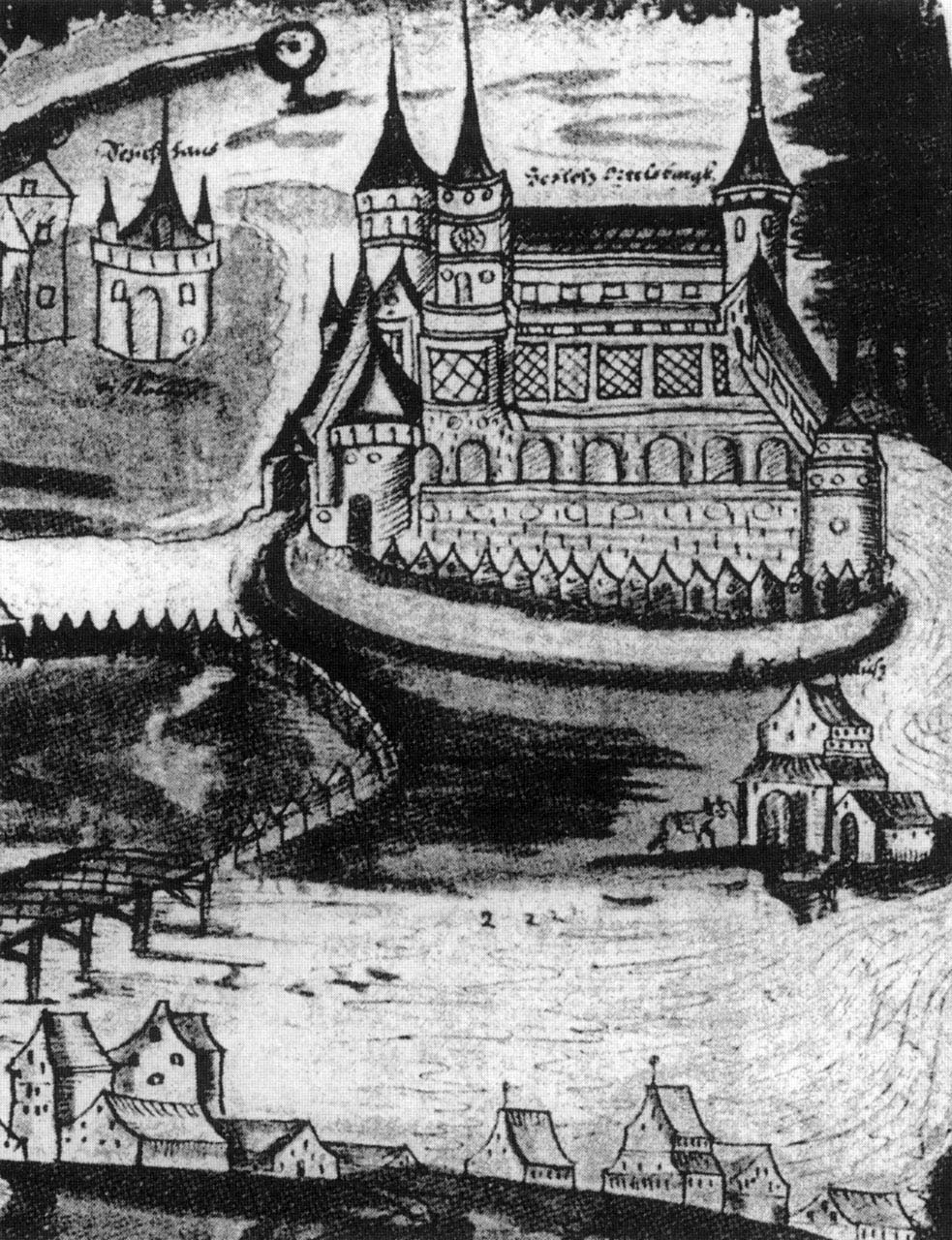
During the Thirteen Years’ War, after the capture of the Szczytno in 1454 by the Prussian Confederation, for almost a year and a half, the Polish garrison was stationed there. Later, they had to surrender the stronghold to the overwhelming Teutonic forces. After the Second Peace of Toruń from 1466, the castle remained within the borders of the Teutonic Knights state, and after secularization in 1525, the seat of the princely starosts was established in it. Due to the proximity of the wild forest, it began to play the role of a hunting residence. The renovation of the castle was commissioned in 1579-1581 by the prince of Prussia, Margrave George Frederick Ansbach. These works transformed the stronghold into an early modern residence, the representative interiors were covered with wall paintings and valuable furnishings. Due to the border location, important diplomatic meetings took place there.
In the 17th century, during the Swedish wars, the castle deteriorated and at the end of that century it was abandoned. In the 18th century, the eastern wing and external fortifications were demolished, in order to obtain building material for the local population. At the end of the eighteenth century, the main tower and the southern wing were also destroyed. The dismantling was continued unfortunately in the next century. The outer ward was destroyed during the construction of a new town hall in the 1930s. The first archaeological research began in 1924, when the outline of the castle’s complex from early modern times was unveiled and partly reconstructed.

Architecture
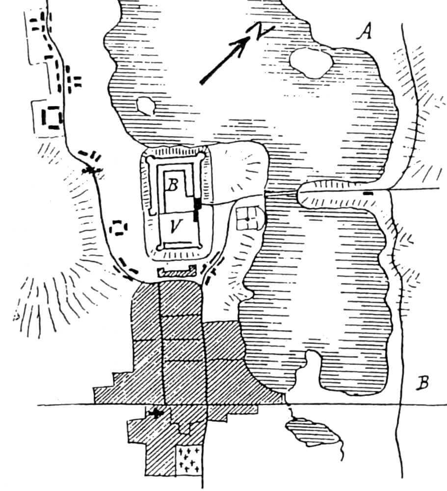
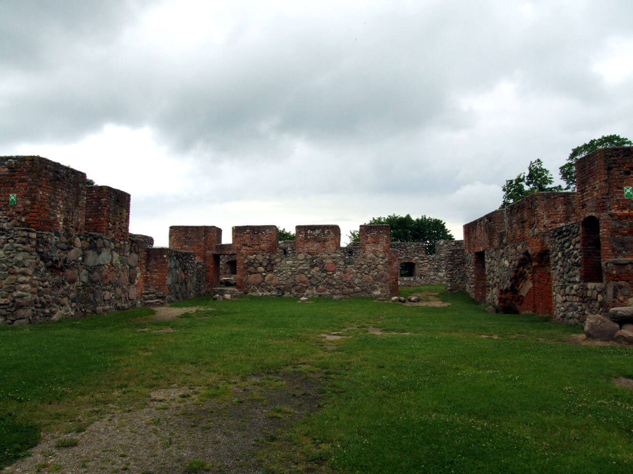
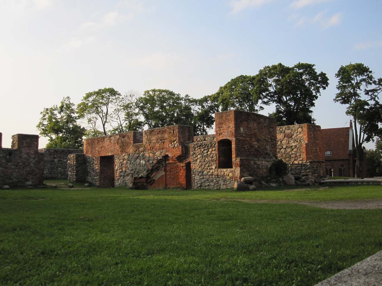
Ortelsburg Castle was located in the southern part of the isthmus between two lakes (Domowe Duże and Domowe Małe). It was built of bricks with a Wendish and Flemish bond, on a very high plinth made of erratic stones, with the lowest layer of foundations consisting of loose stones, not bonded with mortar. The northern part (actually the north-west if we do not use the simplification), closer to the shore of Lake Domowe Duże, was occupied by the main part of the castle. From the south, there was an economic outer bailey with the entrance from the east, facing the narrowing between the lakes. The whole was surrounded by a wide, irrigated moat, which did not include the settlement on the south-eastern side of the castle.
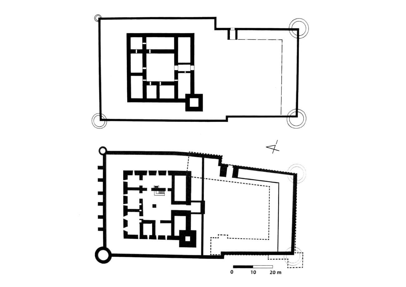
The upper ward was a regular structure, on a square plan with a side length of 38.5 meters. It consisted of four, probably three-story wings, 11 meters wide, with wooden cloisters around a courtyard measuring 15.7 x 15.7 meters. The northern and southern wings probably had the entire length of the side, while the western and eastern wings were shorter by the width of the former. In the south-west corner there was a four-sided main tower on a square plan measuring 9.8 x 9.8 meters, protruding in front of the face of the walls of the adjacent wings. Its height is not known, only that it was placed on a massive stone plinth. The core of the castle was surrounded by an outer wall, but probably only on three sides, because in the south the outer wall turned into the bailey wall. On the northern side, in front of the outer wall, there was a dansker tower, connected to the upper ward by a suspended passage. The second dansker could have been located on the eastern side, but it had a simpler form of a porch on the wall’s crown. The north-east corner was protected by a small cylindrical turret.

The original layout of the castle’s rooms probably followed the typical medieval division, where the basement and ground floor were intended for utility and storage chambers, while the upper floors housed representative and residential chambers. Attics could be used for storage and defense purposes (galleries along the walls). It is known that in the southern wing there was a gate on the ground floor, 9.6 meters long and 3.5 meters wide. It was flanked by two rooms, of which the western one had a brick floor and a stove. It is possible that on the first floor there was a classic division into a chapel with a chancel oriented to the east, an intermediate room and a chapter house, or rather a refectory. The northern wing, measuring 39 x 11.4 meters, had a basement and a porch leading from it to the dansker tower. The plan of the ground floor rooms of this wing was similar to the layout of other main houses in the Teutonic pfleger’s castles, e.g. in nearby Nidzica, also the main houses were often located opposite the entrances. It can therefore be assumed that the northern wing was the main building of the castle in Szczytno, where the most important chambers were perhaps located: a refectory connected to latrines and the pfleger’s chambers.
The buildings of the outer bailey were attached to the walls on the eastern and southern sides. It probably housed the utility rooms recorded in documents (stables, brewery, kitchen, woodcarving house etc.). In the eastern curtain there was also a gate, probably in the form of a tower, equipped with a portcullis uniquely hidden behind the portal and not in an external open recess. In the southern corners of the outer bailey wall there were two cylindrical, quite massive towers. Perhaps it were built as a result of late medieval expansion, as part of adapting defense to the use of firearms.
Current state
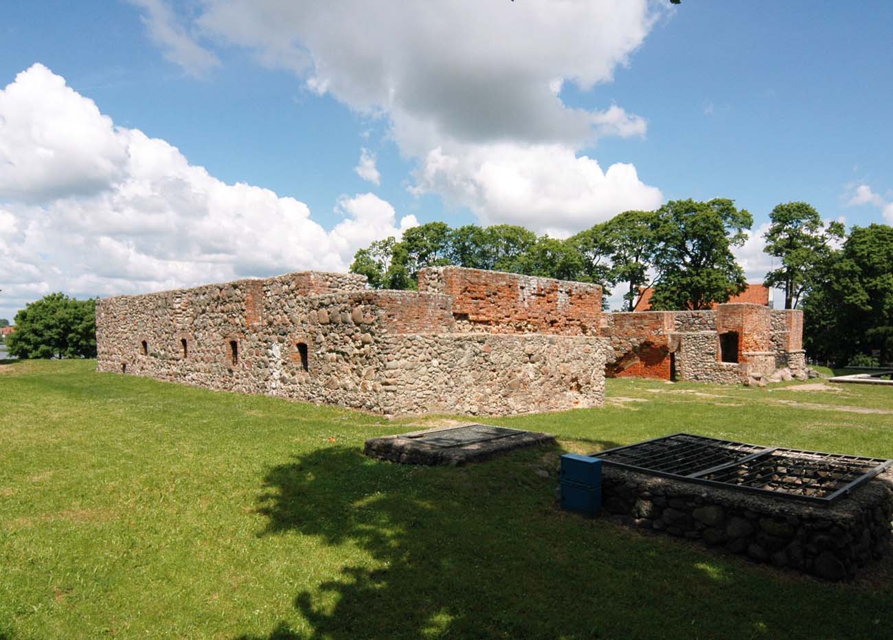
To this day, the walls of the ground floor of three wings of the upper ward have been preserved, with a height of up to 5 meters, together with part of the inner divisions and pillars. However, this is the outline of the building after the transformations from early modern times. Only weakly legible relics left of the southern wing and the main tower. On the site of the outer bailey, there is a town hall from the interwar period.
bibliography:
Garniec M., Garniec-Jackiewicz M., Zamki państwa krzyżackiego w dawnych Prusach, Olsztyn 2006.
Herrmann C., Mittelalterliche Architektur im Preussenland, Petersberg 2007.
Leksykon zamków w Polsce, red. L.Kajzer, Warszawa 2003.
Torbus T., Zamki konwentualne państwa krzyżackiego w Prusach, część II, katalog, Gdańsk 2023.
Wagner A., Murowane budowle obronne w Polsce X – XVII wieku, tom 2, Warszawa 2019.