
History
Tinkinswood chambered cairn also called Castell Carreg, Llech-y-Filiast or Maes-y-Filiast, was built during the Neolithic period, around 4000 BC. It was a collective burial place of the early agricultural community. More than 920 human bones were deposited there, i.e. about 40-50 people of all ages and genders. The bodies were probably exposed to weather conditions before being moved to the burial chamber, which could suggest some form of pre-burial rituals. Pottery items from the Neolithic period and the later Bell Beaker culture were also found, indicating that the tomb was probably used by the community for a long time, perhaps until the Early Bronze Age, around 2000-1500 BC. Moreover, in the Iron Age and the Middle Ages, the burial chamber could be used as a temporary shelter, where boredom was relieved by playing dice and drinking.
Architecture
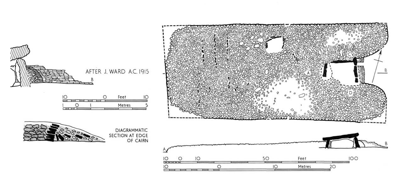
Tinkinswood was built on a low hill, on gently sloping terrain, descending towards the Waycock River flowing to the southwest. It was orientated with its longer axis east-west, with the entrance facing the rising sun, as well as the nearby Maesyfelin tomb near St Lythans, which had similar in form. At Tinkinswood the latitudinal orientation was slightly less accurate, with a slight tilt of the cairn face towards the north.
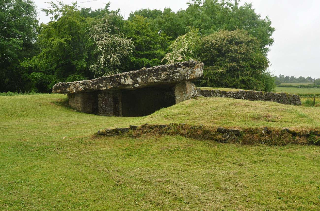
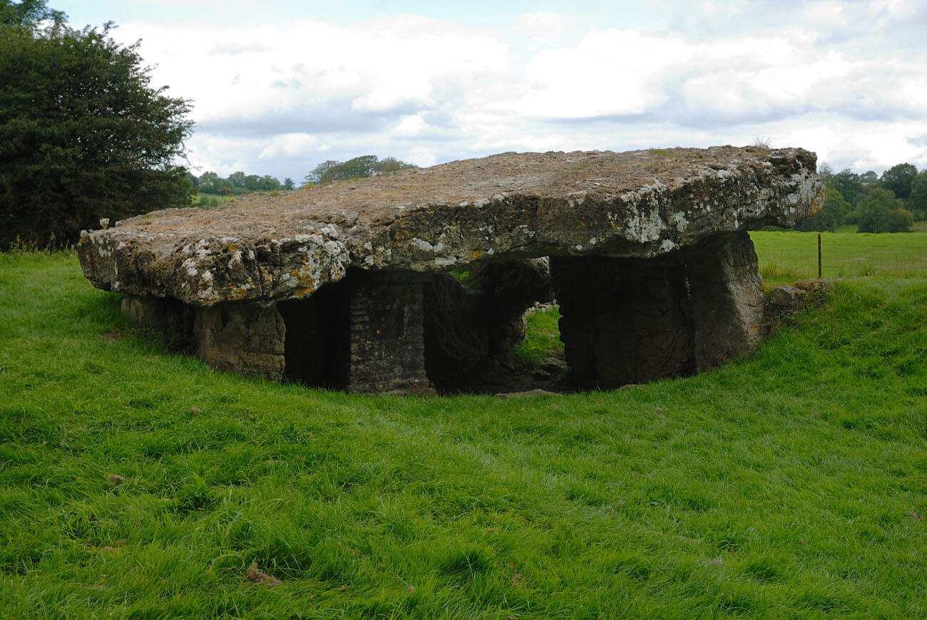
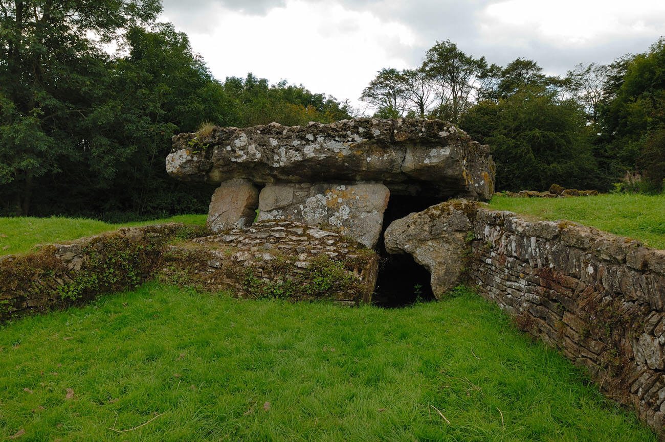
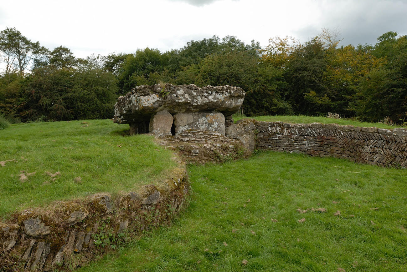
The burial chamber had a trapezoidal shape with dimensions of 5 x 3.5 meters and a height from the ground level of about 1.5 meters. It consisted of several flat, vertically placed stones forming the walls and a large stone on the top, acted as the ceiling. For this function, a boulder weighing approximately 40 tons and measuring 7.3 x 4.3 meters was chosen. The gaps between the side stones were originally filled with walls made of smaller eratic stones laid without mortar. Only the eastern entrance side was covered with a rubble embankment about 0.6 meters thick at the base. The entrance was a gap only 0.8 meters wide, left in the northern part of the eastern wall. Stone slabs were placed in the passage opening, selected to the appropriate size so that they could act as a lintel and a door. The latter were cut to an oblong shape measuring 0.94 by 0.76 meters, in order to be placed in a gap between two paving stones.
Originally, the chamber was completely covered with earth and small stones, forming a mound (cairn) of an oblong shape, about 40 meters long and about 16-18 meters wide. The longitudinal walls of the mound ran more or less parallel. On the eastern side, it had the form of a wedge with two rounded bulges that surrounded a small courtyard ranging from 8 to 4.3 meters wide. This area may have been used for pre-burial ceremonies, because it was located right in front of the entrance to the chamber.
The outer edges of the cairn were faced with a wall of stones laid without mortar, originally 1 to 3 meters high and 1.5 meters thick. Its task was to maintain the compactness of the mound. Moreover, the interior of the mound was divided in the western part by a series of transverse lines, made of stones about 0.6 meters thick and 0.8 meters high. It divided the core of the mound into rubble-filled compartments about 2 meters wide. The rubble was probably covered with clayey soil on the level top.
In the northern part of the cairn, more or less in its middle part (about 2 meters from the external façade), there was a burial chest (cist) formed from a set of narrow stones, in the shape of a square with a side of about 2.9 meters. It may have been an earlier or later burial than the main tomb, but this is difficult to determine because no remains were preserved inside.
Current state
The cairn, despite having its edges lined, was mostly dispersed and leveled over time. Currently, the outline of mainly its eastern part is visible, where the restored wall at the edges of the wedge reaches a maximum of 0.9 meters in height. In the center there is a preserved burial chamber, the huge capstone of which is considered to be the largest in Great Britain. Due to its weight and size, it must be supported now at the rear by a modern pillar. The chamber no longer has its southern wall, looted at an unknown period.
bibliography:
Castleden R., Neolithic Britain: New Stone Age sites of England, Scotland and Wales, London 1992.
The Royal Commission on Ancient and Historical Monuments in Wales, An Inventory of the Ancient Monuments in Glamorgan, Volume I: Pre-Norman, Part I, The Stone and Bronze Ages, London 1976.