
History
The construction of Morlais Castle, named after the nearby river, whose name in Celtic was derived from mawr (great) and glais (stream), was started around 1288 by the Earl of Gloucester, founder of the magnificent Caerphilly Castle, Gilbert II de Clare. He founded Morlais on the northernmost limits of his Glamorgan lordship in order to extend the influence of the de Clare family into the territory of his neighbor, Humphrey de Bohun, Earl of Hereford. The motivation for the construction of the castle could also be the not yet suppressed resistance of the Welshmen, especially the rebellion of Rhys ap Maredudd in 1287.
Building of the Morlais shortly after commencing of the works led to tensions with Humphrey de Bohun. As early as 1289, regent Edmund of Cornwall ordered Gilbert to suspend work on the castle until the king returned from Gascony. In addition, he opposed the great military force Gilbert had garrisoned in Morlais and which Humphrey had complained about. Gilbert ignored the regent’s order, and his resistance continued even after the king’s return in September 1289. At the beginning of 1290, Edward summoned the earl to him, but the earl rejected. The king then issued a proclamation banning private warfare to resolve this local but potentially destabilizing conflict, although also this time Gilbert ignored the ruler by making at least three raids on Humphrey’s lands. He probably believed that the wedding with the royal daughter, which took place in 1290, would protect him from the anger of the ruler. In 1291, Edward I convened a royal commission to consider the matter at Ystradfellte, then summoned the earls to Abergavenny. Meanwhile, Humphrey de Bohun finally lost his patience and organized retaliatory expeditions. In Abergavenny, the king found both earls guilty, they were imprisoned and spent a short period in the Tower of London. Gilbert was fined a larger fine of 10,000 marks for building the castle (Humphrey had to pay only 1,000 marks). Morlais was not recorded than, but it is known that the castle was still in the possession of Gilbert two years later.
The intervention of the king could cause the work on the castle to be suspended and it is uncertain when or if they were resumed. Certainly, however, the stronghold remained in use, because it was conquered by the Welsh during the revolt of Madog ap Llywelyn in 1294 (Llantrisant, Kenfig and Llangynwyd castles also were captured then). After the rebellion was suppressed, Morlais returned to the hands of the de Clare family, but the death of Gilbert de Clare in 1295 caused the castle to abandon and fall into ruin. Morlais was for the last time recorded in documents in mid-1295, when Edward I visited the castle on his way to Brecon. It was probably so badly damaged during the fights with the Welshmen, that the king set up a longer camp in nearby Merthyr, and Morlais only briefly visited.
Architecture
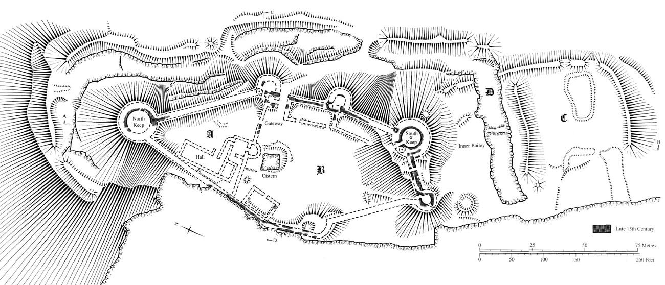
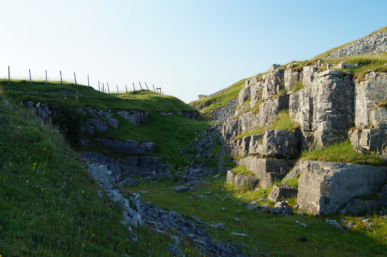
The castle occupied the top of a limestone hill overlooking the Taf Fechan River flowing in a deep ravine on the north and west sides. Its slopes were particularly inaccessible on the west side, also from the north and south, the natural conditions of the terrain were difficult for any attackers. The most vulnerable section was the eastern direction with minimal natural protection from the modest hollow and the view obstructed by the uneven surface behind it. The site was an Iron Age stronghold, and the earlier earthen fortifications were reinforced and incorporated into the new castle, giving it an unusual configuration.
The fortifications had the shape of a pentagon, which in the northern part was divided by an internal, transverse wall 1.5 meters thick, in order to separate the upper ward. The perimeter defensive walls were much more massive, from 2.8 meters up to 3.4 meters thick, with the exception of the safer western curtains. On the north, south and east sides, the castle was additionally surrounded by a rock-cut, 11-15 meters wide ditch, about 3-5 meters deep, located approximately 12-18 meters from the castle’s curtains. To the west, it was unnecessary because of the steep slopes of the hill.
The upper ward had a triangular layout with sides about 45 meters long and was dominated by a large round tower, protruding far beyond the perimeter in the corner on the north side. Its diameter was at least 18 meters, and probably even about 21 meters, with the walls 3.5 meters above the battered plinth, which would indicate that it served as a keep (the room in the ground floor was 11 meters in diameter). This role was also favored by the location of the tower on the northern edge of the upper ward, where it dominated the rest of the buildings and the Taf Fechan valley. The south side of the upper ward was guarded by a horseshoe tower, placed in the center of the inner curtain of the wall, and another horseshoe tower, about 10 meters in diameter, was located on the between the upper and lower ward, on the eastern side. It protected both the gate between the two parts of the castle and the main outer gate. The buildings in the courtyard of the upper ward were an oblong wing measuring 25 x 9 meters, probably housing a representative hall and a small private chamber in the southern part. It were adjacent to a smaller wing, probably of a residential character, added perpendicularly in the southern part of the courtyard and integrated with the transverse wall of the castle. The side wing housed two interconnected small rooms, one of which was accessible from the hall by a passage added from the north and connected with a horseshoe tower. The hall was situated in the courtyard quite unusual, with a certain deviation from the western curtain of the castle. This slant was needed to accommodate a large, 3.3 by 4.6 meter, oval oven positioned at an angle formed with the transverse wall.
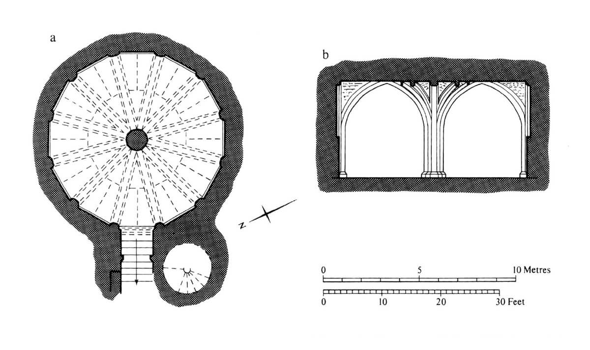
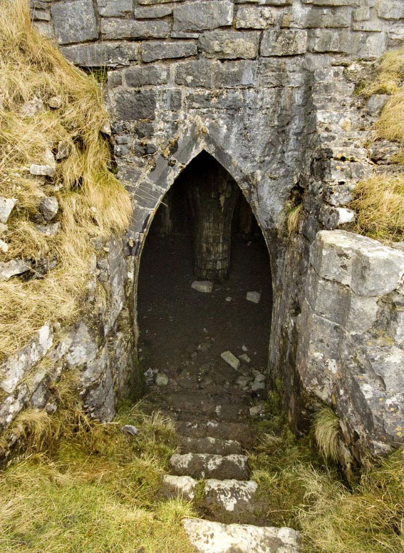
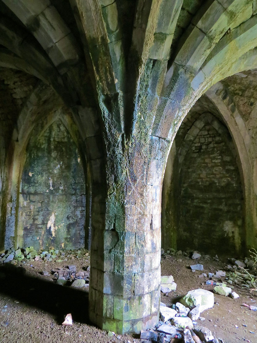
The fortifications of the lower ward of the castle separated a vast courtyard about 60 x 80 meters. Quite unusually, the lower ward also had a large cylindrical tower, probably of the keep type, located on the south-eastern side. It had a diameter of as much as 19 meters, with very massive walls 5 meters thick at the base (thinner above the battered plinth). There was a passage closed with a portcullis, about 5 meters long and 1.6 meters wide, with eight steps leading down, and an ogival entrance portal, opened to a twelve-sided ground floor with a diameter of 9 meters. This chamber was topped with a rib vault supported by a single, massive, polygonal pillar and pilasters placed in the corners. The vault’s ribs were led out without the use of corbels or capitals, although the whole had an elegant decor. Despite the associations with sacral rooms, mainly chapter houses, the ground floor chamber of the keep probably had the function of a storehouse or pantry, because it was not illuminated by a single window. The upper floors were accessible via a spiral staircase, most likely reached from the entrance passage. The room on the first floor was to be heated by a fireplace and equipped with a small chamber with a latrine in the wall thickness, it was also to have passage to the eastern wall-walk. It cannot be ruled out that, as in other keeps (eg Coity), the first floor was also vaulted on the central pillar.

In addition to the massive south-eastern tower, the lower ward was strengthened by another three or four towers, one of which was to be extended far in front of the perimeter of the defensive walls to the south, in order to flank the nearby gate. However, it could very well be a low bastion, not necessarily tower-like, or a completely non-military structure, such as a lime kiln. The south gate itself was only a small postern, 4.5 meters from the keep, located above the level of the courtyard of the lower ward, so wooden stairs or a ladder had to lead to it. In addition to the keep, its protection was provided by a smaller, southern cylindrical tower with an outer diameter of 9 meters (the round room, heated by a fireplace in its basement was 4.2 meters in diameter).
The main gate was on the eastern side, near the north-eastern corner and one of the horseshoe towers. The passage was placed in a four-sided building fully pulled into the interior of the courtyard. The vaulted passage with the pointed portal was the southern part of its ground floor, and in the northern part there was a guard’s room, connected to the passage and attached to the horseshoe tower, but not directly connected to it (the entrance to the tower led from the courtyard of the upper ward). The gate passage was closed with a portcullis, which was most likely raised to the room on the first floor, where a mechanism with a turnstile was operated. The entrance was flanked by the aforementioned horseshoe tower, while another one, situated on the southern side, dominated the causeway falling towards the ditch and the bridge that had to be located right in front of it. Both horseshoe towers were extended in front of the adjacent curtains of the defensive wall, and their storeys were connected by a spiral staircase embedded in the wall thickness. They were very similar to each other, only the tower in front of the causeway differed in the lack of an entrance from the courtyard level.
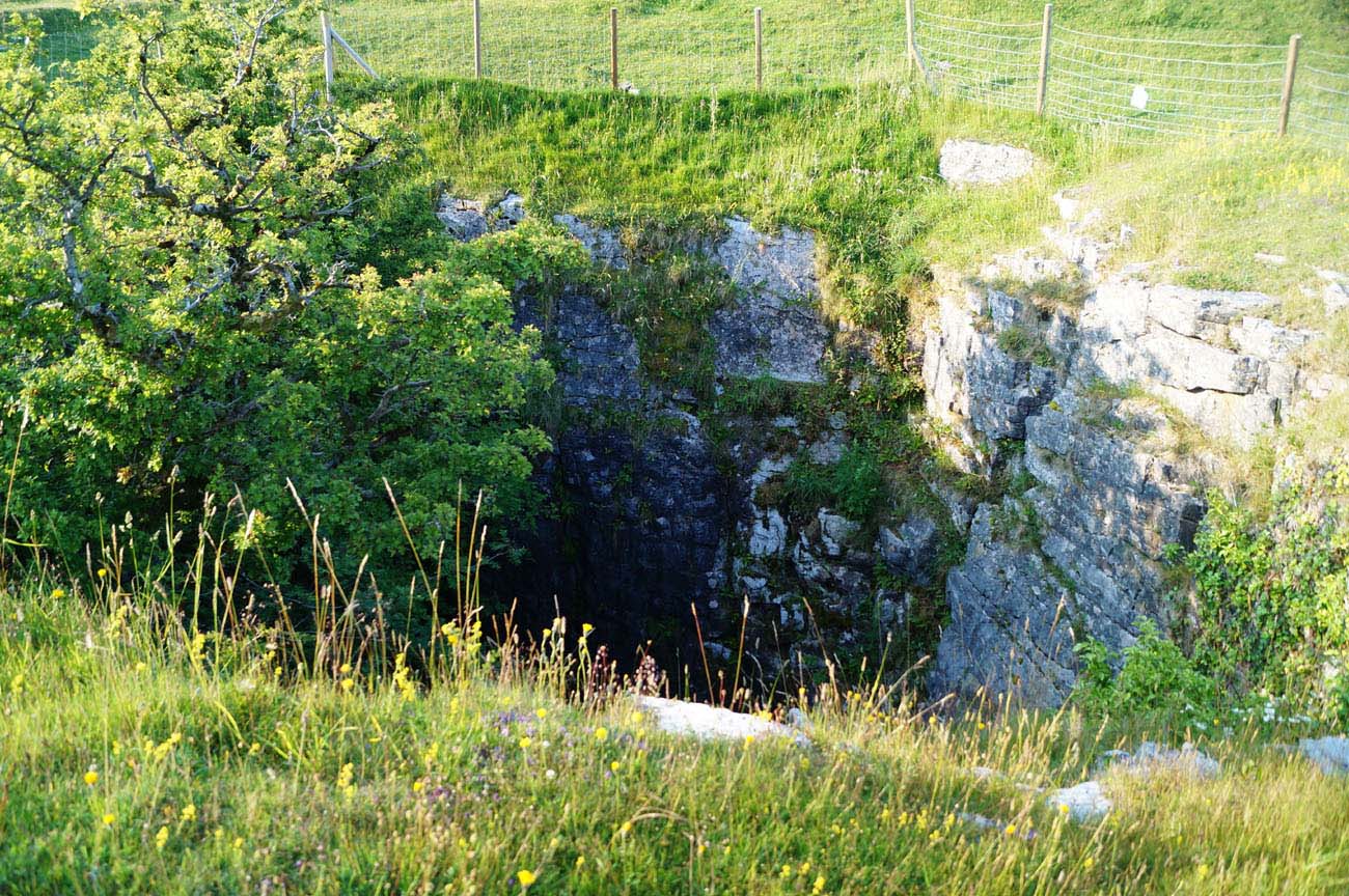
In the courtyard of the lower ward, next to the inner faces of the defensive walls, economic and auxiliary buildings were erected. The wing with thick walls on the eastern side, over 20 meters long, stood out in particular. It consisted of two buildings erected in one line at the curtain of the defensive wall, with northern wall being at the same time the side of the passage of the main gate. Due to location, these buildings served as stables or garrison rooms. In the middle of the courtyard there was a large rainwater tank carved in the rock base. Roughly square, with sides 8 meters long, it lay opposite the eastern gate and next to the horseshoe tower of the transverse wall. It was supposed to be up to 21 meters deep (currently only 11 meters, but the bottom is covered with rubble). In the western part of the courtyard there was another building, 15 x 10 meters, accessible through a door in the middle of the eastern wall, as well as by stairs leading down to the basement.
On the south-eastern side of the castle, an outer bailey was created, perhaps intended only for grazing cattle and livestock, and certainly without stone buildings. It was protected by an earth rampart about 12 meters wide and about 1 meter high, and a ditch covering an area of about 57 x 70 meters. The ramparts of the outer bailey were probably created already in the Iron Age and were reused in the Middle Ages, when they were topped with a palisade.
Current state
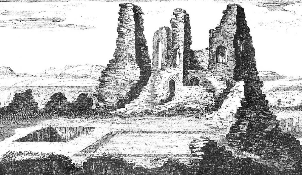
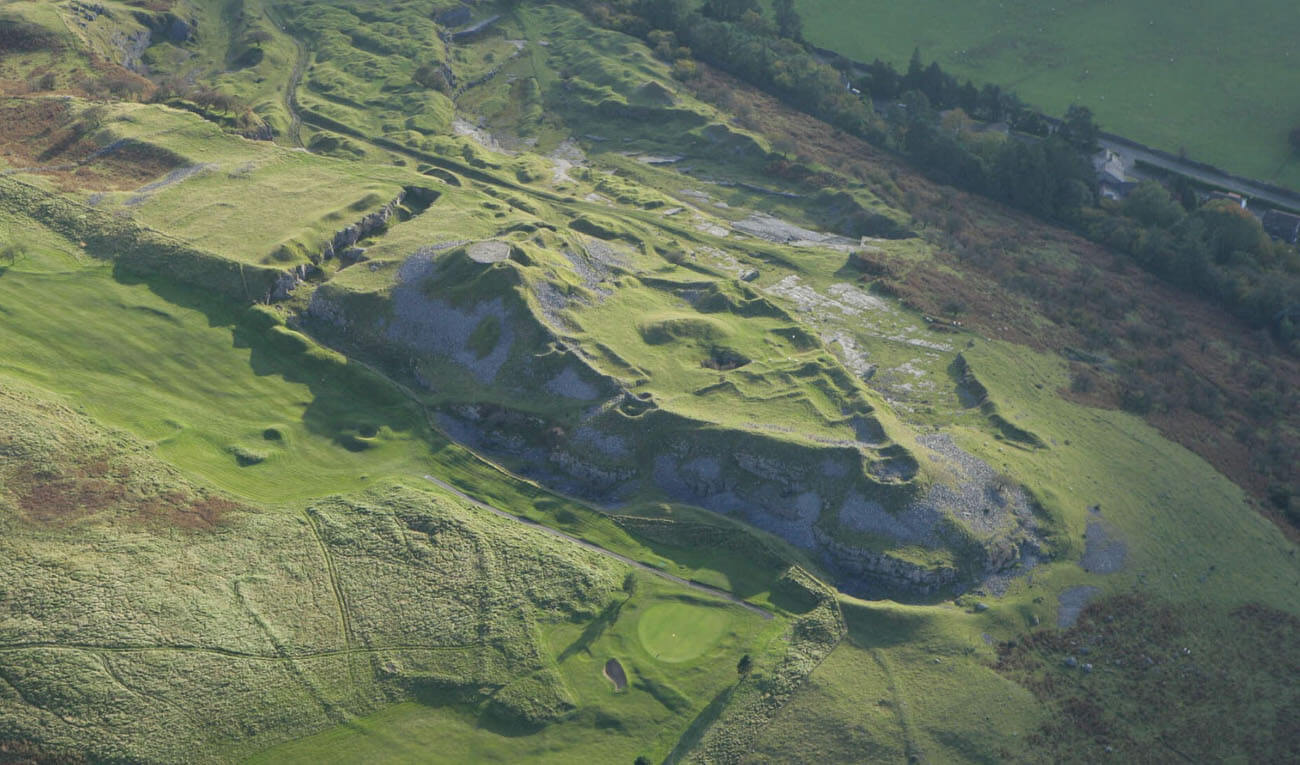
The castle has not survived to modern times. Its layout is best seen from aerial view, only the remains of a dry moat, a water reservoir at the outer ward and small fragments of walls are visible on the ground. The most interesting element is the surviving chamber of a cylindrical keep with a preserved central pillar, vaults and an ogival entrance portal. Entrance to the castle area is free.
bibliography:
Davis P.R., Forgotten Castles of Wales and the Marches, Eardisley 2021.
Kenyon J., The medieval castles of Wales, Cardiff 2010.
Salter M., The castles of Gwent, Glamorgan & Gower, Malvern 2002.
The Royal Commission on Ancient and Historical Monuments of Wales, Glamorgan Later Castles, London 2000.