

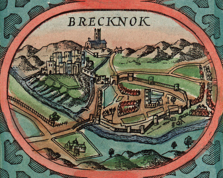
History
Brecon Castle (according to tradition named after the Welsh chieftain Brychan) was built by the Anglo-Norman Lord Bernard de Neufmarché, after he defeated the Welsh ruler Rhys Ap Tewdwer at the Battle of Brecon in 1093. The Anglo-Normans then invaded all of South Wales, defeating the local Celtic rulers and conquering the kingdom of Brycheiniog. Bernard was than awarded the title of Lord of Brecon in recognition of his services. He built the castle in a naturally defensible location at the confluence of the Usk and Honddu rivers, where it could guard the crossings and profit from the watermills. It also served as the administrative caput of the Brecon Lordship, from where the subordinate estates were governed.
Already in 1094, the castle was besieged by the Welsh, but the crew got relief brought by Roger de Newburgh. Bernard died in 1125 leaving Brecon secured and developing. It became the property of Miles of Gloucester, the first Earl of Hereford, who married Bernard’s daughter, Sybil, and then to his son Roger Fitzmiles, the second Earl of Hereford. In the second half of the 12th century, the castle passed into the hands of the de Braose family, as a result of further marital affinities. When they rebelled against the English king John, he conquered the castle in 1207. The de Braose family, specifically the brothers Giles and Reginald de Braose, captured the castle during the First Barons’ War in 1215. Brecon soon became the target of attacks by the Welsh of Llywelyn ap Iorwerth, who raided the castle and town in 1217, 1231 and 1233. During the latter, the town was burnt, but the castle managed to defend itself.
In 1241, Brecon was took over by the Bohun family, as a result of the marriage of Humphrey de Bohun, Earl of Hereford, with the heir of the Braose family, Eleanor. The new owner gave Brecon under the management of Roger Mortimer and contributed to the significant expansion of the castle, especially the fortification of the outer bailey. Despite this, in the second half of the 13th century, Brecon was repeatedly attacked by the Welsh of Llywelyn ap Gruffydd, who for a short period managed to capture the castle in 1263 (the garrison surrendered). Two years later, the castle was recaptured by prince Edward, but in the same 1265 it was again conquered by the Welsh. They also caused severe damages in the attacks of 1273 and 1295. A calmer period for Brecon did not come until the 14th century. Thanks to this, at the beginning of the century, Humphrey VII de Bohun was able to enlarge the castle by adding a great hall.
In 1322, the castle was taken over by King Edward II, after the death of Humphrey VII de Bohun at the Battle of Boroughbridge, during internal fights on the side of Thomas, Earl of Lancaster and the rebel barons. It later returned to the de Bohun family, and then became the property of Henry, Duke of Lancaster, married to Mary, heiress of Humphrey X de Bohun, who died in 1372. Henry of Lancaster in 1399 took the English throne as Henry IV, and entrusted Brecon to Sir Thomas Berkeley at that time. He managed the repairs and expansion of the castle in the early 15th century, preparing Brecon for defense against the rebellious Welsh of Owain Glyndŵr. In 1404, 100 man-at-arms and 11 horse archers were to be sent to the castle, but in the end no attempt was made to capture it.
In the later 15th century, Brecon passed to the Dukes of Stafford of Buckingham. The last of them were executed during the reign of Henry VIII Tudor, and the castle complex began to fall into ruin from that moment. The castle was besieged for the last time by Rowland Laugharne, commander of Parliament’s troops during the English Civil War in 1645. Later, it was largely dismantled. The first repair works began in the 19th century, thanks to which the castle was transformed into a hotel.


Architecture
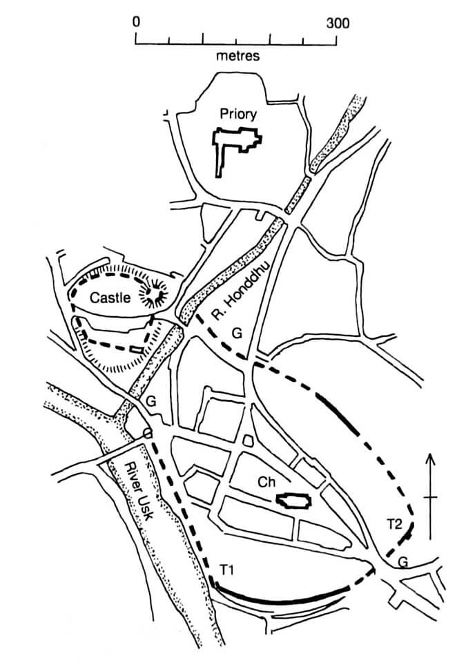
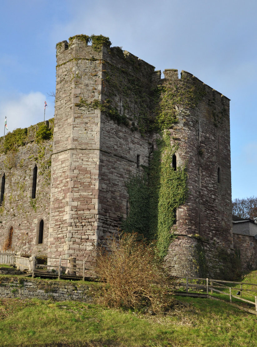
The castle was erected on a high hill, the slopes of which fell in the east towards the Honddu River, flowing into the larger Usk River on the south side of the stronghold. Initially, it took the form of a motte and bailey. It consisted of a huge 15-meter high earth mound on which a wooden keep was erected, surrounded at the beginning of the 13th century by a polygonal stone perimeter wall (shell keep), the material for which was taken from the Roman ruins of the town of Caer Badden. The defensive wall was 1.7 meters thick, and it surrounded a courtyard about 15 meters in diameter. In 1233, a stone wall was also built to protect the outer bailey located in the south-west. This wall replaced an earlier earth rampart and a ditch, and the entire castle was than shaped like a triangle measuring 90 x 120 meters, squeezed between the Honddu and Usk rivers.
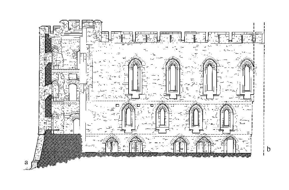
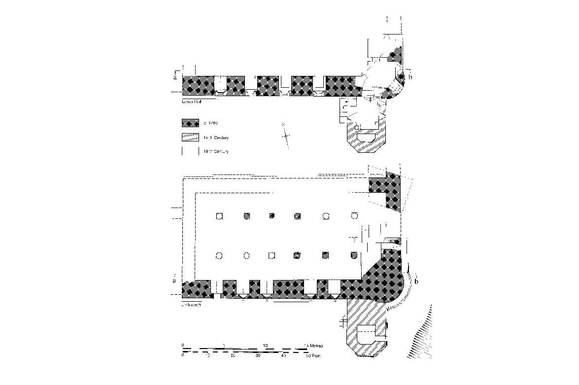
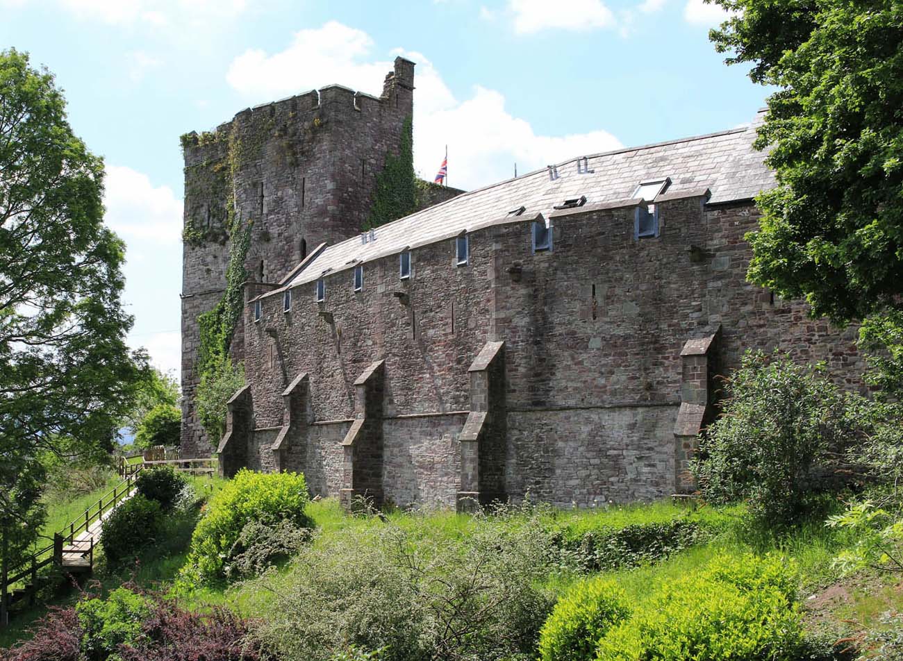
At the turn of the thirteenth and fourteenth centuries, in the southern part of the outer bailey, a great hall was built, to which at the beginning of the fourteenth century a polygonal, south-facing Ely Tower (named after the bishop of Ely, imprisoned there in 1483) was added. It partially covered the earlier corner, cylindrical and shallow turret of the great hall building. Rooms equipped with latrines were placed in the new tower. The hall building itself was about 21 meters long and the walls were 2.4 meters thick. It contained three stories, two of which were separated by a flat wooden ceiling: the middle story, lit by narrow, pointed windows, and the upper story, lit by narrow but tall pointed windows with trefoil heads. The lowest story, intended for economic functions and defense, was lit only by narrow slits. Its interior was divided into three aisles by two rows of octagonal pillars supporting the vault. The building was topped with battlements, with arrowslits pierced in the merlons.
The main castle gate was directed to the north-west and reinforced by two semicircular towers, a portcullis and a drawbridge. It was connected with a defensive wall surrounding the entire castle with a shape similar to a triangle. Inside there was the aforementioned three-story building of the great hall with the Ely Tower, and next to the private living quarters of the castle lord. Medieval documents contain references to other rooms and buildings: the chambers of the constable and the tax collector, the chapel, the treasury, the kitchen, and the stables. The well was described as being 9 meters deep.
The original settlement may have been located on the northern side of the castle, between its fortifications and the Benedictine priory to the northeast. However, around the turn of the 12th and 13th centuries, settlement moved to the other side of the river, where topographical conditions were more favorable for development. The town fortifications extended there for a distance of approximately 600 meters, on a plan roughly resembling an elongated oval. They consisted of a defensive wall reinforced with ten towers, most probably built on a circular plan. The four-sided towers were protruding 3 meters in front of the face of the wall, with sides about 6 meters long. Four gates led to the Brecon: north, west, south-west and east one. Two of them, west and south-west, were located close to each other and facing the bridges over the rivers Usk and Honddu. The north gate (Struet Gate) led towards the priory and the east gate (Watton Gate) towards Crickhowell and Abergavenny.
Current state
Currently in Brecon you can see a mound with relics of the oldest part of the castle, located in the gardens of the bishop’s palace. In the area of the contemporary hotel there is a fragment of a great hall with a tower standing next to it and a section of the defensive wall constituting the outer wall of the building. The castle itself can be visited independently of the hotel. The town fortifications have only been partially preserved in the southern part of the former circuit, together with the relics of two towers.

bibliography:
Haslam R., The buildings of Wales. Powys (Montgomeryshire, Radnorshire, Breconshire), London 1979.
Lindsay E., The castles of Wales, London 1998.
Morgan D.R., Towards a topography of early Brecon, “Brycheiniog”, 23/1989.
Pettifer A., Welsh castles, Woodbridge 2000.
Salter M., Medieval walled towns, Malvern 2013.
Salter M., The castles of Mid Wales, Malvern 2001.