
History
In the Middle Ages, documents did not produce any information about the Žakýl castle (Hungarian: Brezó), or it did not survive later centuries. Based on archaeological finds, it is only known that it was built in the second half of the 13th century. Together with several other castles in the Štiavnickie Mountains (Zvolen, Sklené Teplice) it formed a network with visual communication. Žakýl probably protected the old route, known as the Via Magna, which since Roman times ran from the south through Kremnica, Turec and Orava to Poland. In the late Middle Ages, the route lost its importance, but silver from Kremnica was still transported there.
The name of the nearby village, written in the 14th century as “Zekel”, would indicate the connection of the castle or its subordinate estates with the Szekler ethnic group (Hungarian: Székely) or possibly with the Piechenegs. In the middle of the 14th century, the Žakýl estate was to be taken over by the royal administration, and then incorporated into the Šášov estate. However, in 1352, Louis I of Hungary issued a document in which ordered the castellan of Šášov castle to return the villages of Kopanice, Karling, Sigelsberg, Banská Belá, Banský Studenec and Žakýl (“Sekken”) to the town of Banská Štiavnica, due to their alleged illegal takeover by the earlier castellan of Šášov , Master Vesszős. This would indicate that the castle and the village of Žakýl were owned in the first half of the 14th century by the townspeople of Banská Štiavnica.
The Žakýl castle probably functioned until the 15th century, until the period of turmoil during the internal struggles for the Hungarian crown and clashes with the post-Hussite units, or a little later, until the time of chaos after the death of King Matthias Corvinus. The only direct record of it was made only in 1560, when it was already abandoned and presumably ruined. At that time, the border between the settlement of Horné Opatovce and Teplá was drawn, which was to run by the well under the “old castle” and near the hill called Kráľov Stôl (Royal Table).
Architecture
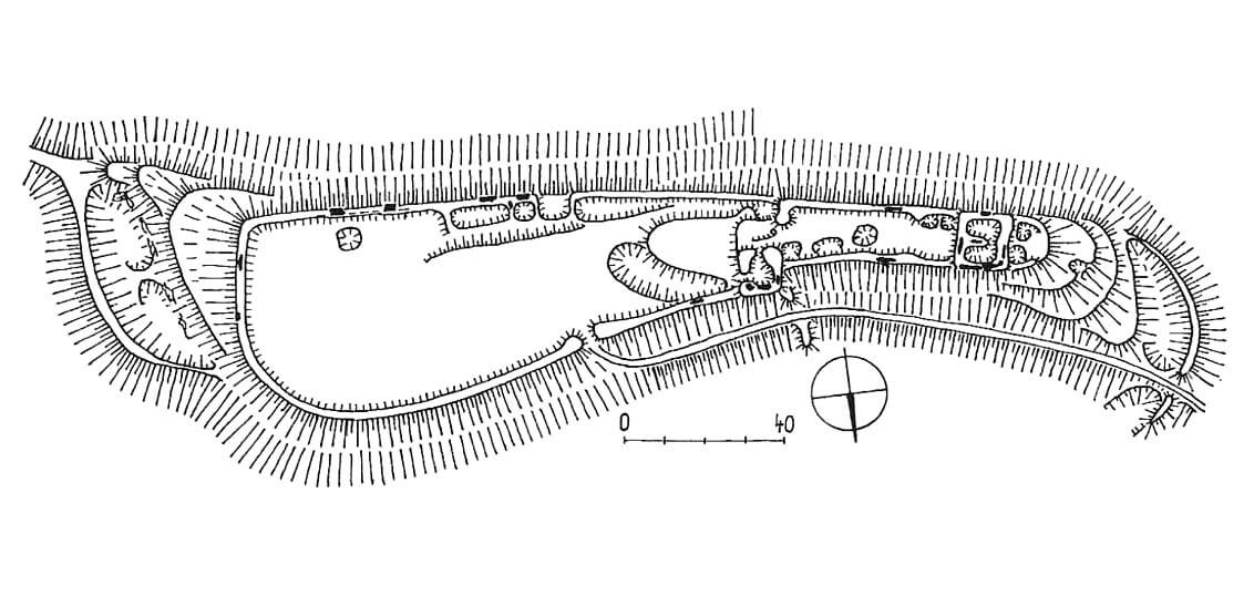
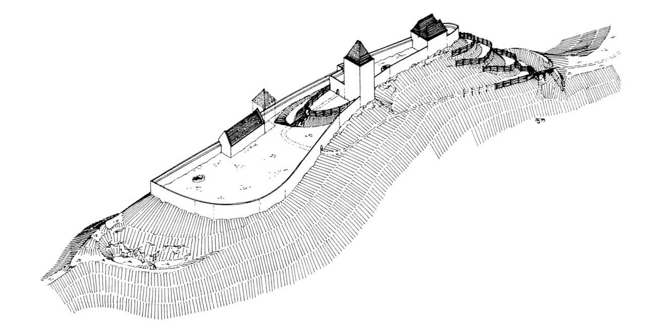
The castle was erected on an elongated mountain ridge with a height of 812 meters above sea level, near the route running in the valley on the western side. The dimensions of the upper ward, occupying the western part of the hill, were approximately 80 x 16-25 meters, placing it among the larger medieval strongholds in the region. The outer bailey was even larger, measuring 120 x 40-60 meters, located in the eastern part of the ridge. The whole, due to adaptation to the natural conditions of the terrain, had a strongly elongated shape with an east-west axis.
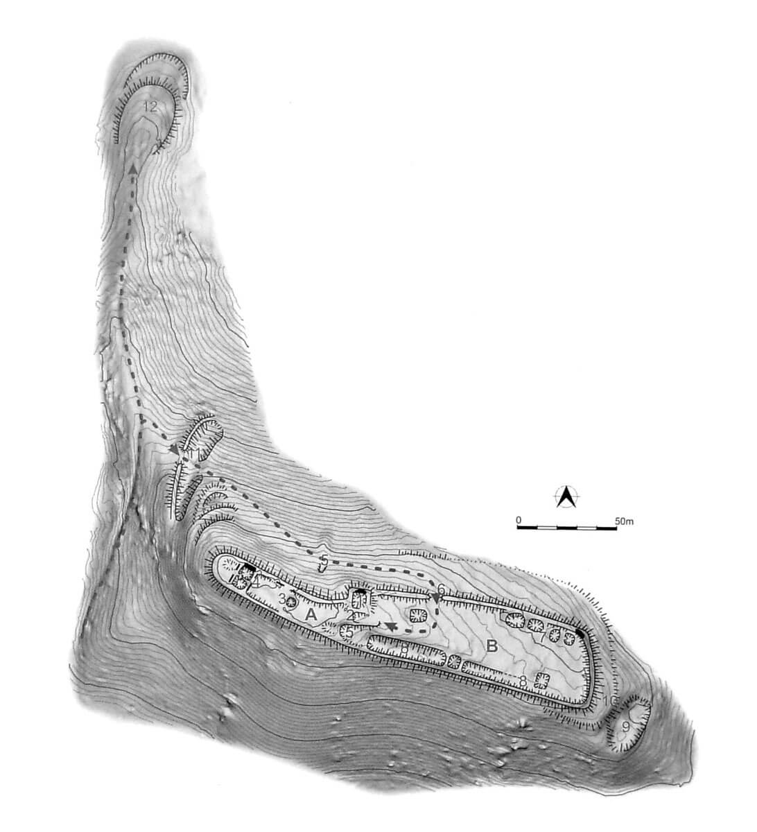
The entrance to the castle was placed in the northern part of the outer bailey, then, after turning west, the road led along the slope of the hill along the upper ward. Several dozen meters further, on the north-western side of the castle, the access road was protected by a transverse ditch and an earth rampart, behind which the hill formed a slightly lower, 140-meter-long ridge, directed north-west. At its end, oval fortifications were erected, extended far into the foreground, protected by a moat and an earth rampart. These advanced fortifications occupied an area of about 38 x 26 meters.
The upper ward was surrounded by a stone defensive wall and secured by earth ramparts created on the western, most endangered slope, formed to the shape of descending terraces. In the highest part of the area, there was a large, square tower, approximately 10 x 10 meters in size, and a residential house, approximately 12 x 14 meters in size. Situated in the north-eastern corner of the courtyard, at the junction with the outer bailey, the tower flanked the nearby entrance gate from the outer bailey, as well as the access road to the castle. The residential building, on the other hand, was located in the western, narrowest part of the ridge, with the western edge probably left empty in order to separate a small courtyard in front of the wall. In the center of the main part of the courtyard was a rainwater tank. Two passages of undetermined purpose were carved in the rocks under the castle. The first was about 20 meters long, and the second about 5 meters.
From the east, the upper ward was separated from the outer bailey by a ditch up to 10 meters deep. Also, the outer bailey on the eastern side was secured with a dry moat 20 meters wide and 10 meters deep. The main defensive role was played by a stone wall 1.8 meters thick, led along the edge of the slopes. In the spacious courtyard of the outer bailey, there were buildings of unknown, but probably economic purpose. They were located mainly at the southern part of the defensive wall.
Current state
The elongated shape of the castle is visible in the heavily forested area only in the form of earth ramparts, which in places hide stone foundations. In the middle of the former upper ward there is a pit covered with leaves, the remains of a water tank. Access to the castle grounds is possible via the blue tourist route from the hamlet Žakýl, part of the village of Podhorie. It leads along the western slope of the hill, turns east at the crossroads and after about 30 meters ends at the protruding embankment of the upper ward. Taking the northern path at the crossroads will lead to a 160-meter-long ridge, at the end of which there are relics of fortifications advanced into the foreground.
bibliography:
Bóna M., Stredoveké hrady na strednom Pohroní, Nitra 2021.
Bóna M., Plaček M., Encyklopedie slovenských hradů, Praha 2007.
Wasielewski A., Zamki i zamczyska Słowacji, Białystok 2008.