
History
Teplica Castle was probably built in the second half of the 13th century. At that time, it guarded the road from the Hron valley to Banská Štiavnica. For the first time as “Teplicze Castle” it was recorded in documents in 1456. At that time, Jan Jiskra of Brandýs, a mercenary in the service of Queen Elizabeth, and then Ladislaus the Posthumous in the fights for the Hungarian crown with Vladislaus Jagiellon, confirmed the receipt of a significant sum of 400 guilders from nearby mining towns to cover the costs of urgent repairs at the castle. The connection of the castle with mining towns was confirmed again in 1463, when Andreas Modrer, administrator of the Kremnica mining chamber and commander of the Teplica castle garrison (“capitaneus castri Thyplicz”), leased a mill near the town of Pukanec from a Benedictine abbot.
At the end of the third quarter of the fifteenth century, the owner of the castle was the archbishop of Esztergom. When in 1471 Archbishop Jan Vitéz organized a conspiracy to overthrow the power of King Matthias Corvinus, the castles subordinate to him passed to the side of the Polish prince Casimir Jagiellon, son of King Casimir IV. Vitéz’s schemes were quickly discovered and suppressed, and Matthias Corvinus handed over the castle to his ally, the bishop of Eger, Jan Beckensloer. This formal act, however, did not change the fact that the Teplica castle garrison under the command of Stanislav of Košec remained loyal to the Polish side. Only after the death of Jan Vitéz in 1472 and the end of the conflict, Teplica together with the castles of Breznica and Revište surrendered to the Hungarian ruler.
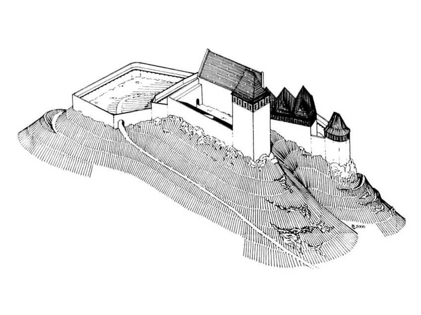
In the 70s of the 15th century, King Matthias Corvinus gave the castle to his wife Beatrice of Aragon, who incorporated the settlement below the castle into the Šášov estate. Then, in 1489, she donated the manor in the village to her courtier and zupan of Zvolen named Perott. The new owner, during the unrest after the death of Matthias Corvinus, supervised the repair of the dilapidated castle and the appropriate equipment of the rebuilt stronghold (“noviter constructum”), which Beatrice financed from the royal chamber’s income. Construction works were completed before 1494, when the state of the castle was presented by the then castellan Ferdinand. However, after the annulment of Beatrice’s marriage to Louis II, she lost interest in Hungarian goods, as did Perott, who in 1500 sold the manor in Sklené. The castle probably fell into decline again soon after or was even abandoned.
The defeat at Mohács in 1526 and the Turkish threat made the town of Banska Štiavnica finance the maintenance of watchtower at the Teplica castle. A few decades later, due to the renewed threat of Turkish invasion, it was again used to a limited extent to control the surrounding roads. According to a document from 1564, the guard in the old castle above the village of Sklené was supposed to give fire alarm signals in case of danger. In the 17th century, the building was completely abandoned, which gave it the name Empty Castle. In the 19th century, it began to be dismantled in order to obtain building materials for the nearby church and houses in Sklené.

Architecture
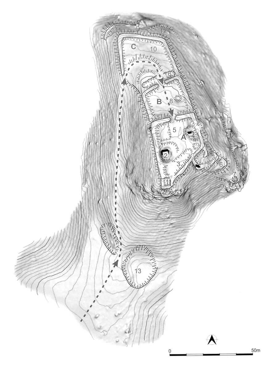
The castle was built on a hill 629 meters above sea level, on the western side of the Sklené Teplice settlement located in the valley, and aon the southern and western side of the mountain road from the Hron River valley to Banská Štiavnica. The high hill provided control over the area and visual contact with the nearby castles of Revište and Žakýl. The road to it led through a pass connecting two hills on the south side, through the advanced fortification, a transverse ditch created about 50 meters in front of the castle and further along the western slope of the castle hill, where it reached the outer bailey.
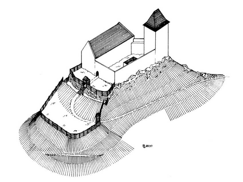
The core of the castle occupied the southern, flattened part of the trapezoidal, rocky hill measuring 25 x 22 to 40 meters. It consisted of a defensive wall connected to a four-sided tower placed in the southern corner of the courtyard and the eastern residential house on the plan of an elongated quadrangle. Perhaps another building or a wing of the main palace at the diagonal curtain of the wall was connected to the tower. In the courtyard, in the vicinity of the tower towering over the access road, there was a water tank carved in the rock. It had dimensions of 5.1 x 3.9 meters, with the interior covered with carefully laid lime plaster, protecting rainwater from soaking into the ground.
From the north, the upper ward was adjacent to the wooden and earth, lower outer bailey, divided into two separate areas. The part closer to the upper ward occupied a rectangular area measuring 26 x 20 meters, while the northern part of the outer bailey was about 30 x 28 meters and had irregular shape. Both parts were separated from each other by a transverse ditch about 5 meters wide, carved in the rock. Through both parts led the access road to the core of the castle, which in the outer part, just before the ditch, took a sharp turn. From the north and west, the outer bailey could be protected by earth ramparts. In the fifteenth century, from the south-eastern side, a second bailey was built, protruding about 26 meters from the core of the castle. On the rocky promontory constituting the edge of the courtyard, it was probably protected with a round tower, and higher on the slope, near the wall of the upper ward, it could have housed a residential building.
The advanced fortifications mentioned above were probably built during the castle expansion from the second half of the 15th century. Located about 450 meters south of the castle, it had the shape of an oval measuring 45 x 30 meters, surrounded by an earth rampart and a ditch, which separated an area of about 27 x 15 meters. Located on a rocky ridge, the fortifications controlled the road to the castle running below from the east. It is also possible that the fortifications were the remains of a fortified camp of troops besieging the castle, which in this way isolated the local garrison.
Current state
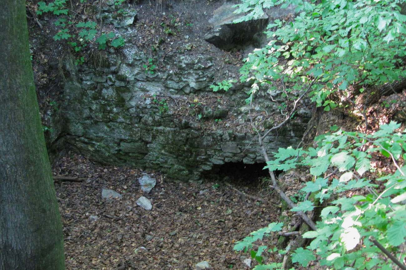
The castle has not survived to modern times. Only earth embankments and fragments of brick foundations of a residential building are visible, as well as the remains of a rainwater tank. Admission to the forested area of the former castle is free. It can be reached via the yellow tourist trail from the town of Sklené Teplice, which after about 1 kilometer on the eastern slope of the hill joins the green trail and turns north to the original access road to the castle. Taking the southern road will provide access to the old advanced earth fortifications, protruding into the castle foreground.
bibliography:
Bóna M., Stredoveké hrady na strednom Pohroní, Nitra 2021.
Bóna M., Plaček M., Encyklopedie slovenských hradů, Praha 2007.
Wasielewski A., Zamki i zamczyska Słowacji, Białystok 2008.