

History
Šebeš Castle (Sebeswar) was probably built in the last quarter of the 13th century. In 1285, King Ladislaus IV of Hungary gave a man named Buda a property called Holloudzalas (House of the Raven), and the Zupan Vavrinec confirmed that the borders of his estates were properly measured. Ladislaus IV managed to confirm the ownership of the land to the sons of Buda: Petr, Ladislav, Imrich and Donč, but his successor, Andrew III, in 1300 gave the local property to the knight Kvet. After the death of Andrew III, the Šariš region was controlled by the oligarch Omodej Aba, who gave the knight Sinka, son of Tomáš, half of a large meadow in exchange for war merits in the campaigns of King Andrew III. This meadow was said to lie between Solivar Castle and the unnamed castle of Sinka. In 1307, a settlement outside the castle was recorded in the documents for the first time, mentioned during the exchange of property made by Omodej Aba and the Sinka, while in 1315 King Charles Robert confirmed his estate together with the Šebeš castle, which was the first record of it in the documents.
In the Middle Ages, the Šebeš estate, which included the villages of Vyšná and Nižná Šebastová together with the parts of Severná, Podhradík and Okružná, was almost always owned by the descendants and heirs of the knight Sinka. In the second half of the 14th century, Petr and Pavol sided with the opponents of Sigismund of Luxembourg, which resulted in the loss of the castle and property. Only when in 1396 Sibos Šebeš fell in battle with the Turks, the king showed mercy and returned the family seat in 1404. After the death of King Matthias Corvinus, the owners of the castle once again opted for the wrong side and supported the Polish candidate to throne, Jan Olbracht. During this period, Polish troops preparing to march to nearby Prešov camped in the castle. For this reason, after Olbracht’s defeat, the new Hungarian king, Ladislaus II, transferred Šebeš to the town of Košice in 1491, but soon after the property returned to the original owners.
The functioning of the castle in the Middle Ages was affected by disputes between its owners and the Solivar estate and the town of Prešov. Initially, they were arranged correctly, but in 1363 the owners of Šebeš took part of the land of the Solivar manor. Similar land disputes were also conducted with Prešov, after part of the townspeople’s possessions were taken away, which, however, had to be returned in 1394 as a result of complaints. Continuation of disputes took place in 1475, when representatives of the town and the owner of the Sebeš estate were summoned to the royal court. Disagreements apparently remained, because in 1528, the inhabitants of Prešov captured the lands of Helena, the widow of Ján Sebessy, together with the castle. This state of affairs did not last long, as soon after the goods were returned to their original owners. The culmination of the conflict was the capture of the castle by armed men led by mayor Imrich Fontanus in 1550 (or possibly in 1537). When the last owner of the castle, František Sebessy, asked for reconciliation, the people of Prešov took advantage of the invitation to the castle and attacked. The owner of the castle together with the castellan Mikláš Gergelaky were hanged at the gate and the castle was plundered to such an extent that it was uninhabitable. The king punished the townspeople, but the castle was never rebuilt and fell into ruin, because the Sebessy family had a more comfortable court in Nižné Šebastová.
Architecture
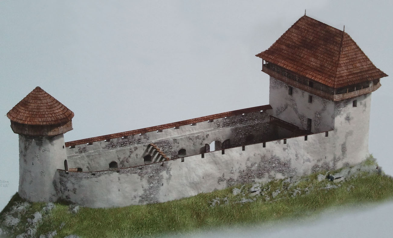
The castle was erected on an elongated and very narrow, rocky ridge with a height of 529 meters above sea level, protruding like promontory from the massif of Slanské Vrchy. From the south, the slopes descended steeply to the mouth of the Šebastovka stream valley, while from the west and north it descended to the relatively even areas of the Košice Basin. In the east, the castle hill was connected by a saddle with the mountain massif, which made the slopes in this section less high and steep. The rocky ridge provided very good defensive conditions, but did not leave much space for buildings and complicated the access road to the castle.
On the eastern side, the ridge was cut by a wide ditch carved in the rock, from 5.5 to as much as 13 meters deep, in front of which the economic facilities of the castle were probably located. The main part of the castle was built on an oval plan, about 40 meters long and 7-8 meters wide. In the western, safest part, there was a four-sided residential building measuring 9 x 7 meters, and on the eastern side a round tower with a diameter of 5 meters and walls about 1.5 meters thick. Both of these parts were connected by a massive defensive wall 2.2 meters thick, running along the edge of the slopes of the hill, separating a small, narrow courtyard. The castle courtyard was inclined towards the south, with the difference in height between the northern and southern edges exceeding 1.5 meters. From the outside, the wall had a diagonal plinth, turning into a more or less vertical face. The entrance to the castle was possible from the south, after a slight bulge of the area, from where a narrow path between the wall and the escarpment reached a ditch over which a wooden bridge was placed.
The main residential building, with a plan similar to a rectangle, was built into the western part of the courtyard in such a way that it probably occupied its entire width. The ground floor consisted of a northern room measuring 4.5-5.4 x 4 meters with a floor made of mortar and clay, and plastered walls. The entrance to it from the side of the courtyard was in the south-eastern corner, and the threshold of the portal was about 75 cm above the level of the courtyard. In addition, in the ground floor there was a smaller, side room, accessible from the courtyard through a separate entrance. The entire lower part of the building probably served storage and economic purposes and was not connected to the upper floor, which probably had a separate entrance. One or two upper floors had to perform representative and residential functions. Some of the chambers there were heated with tiled stoves.
Current state
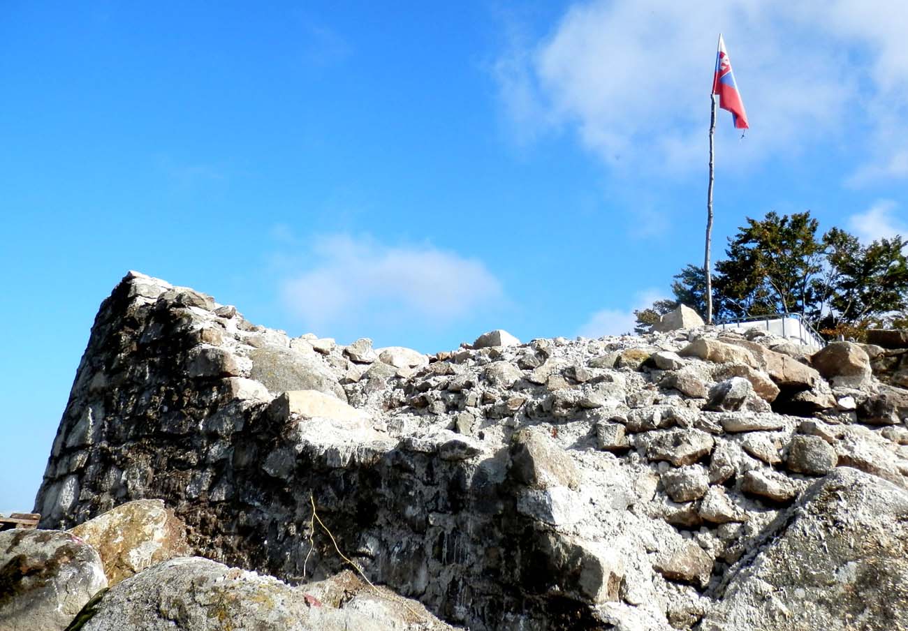
The castle has not survived to modern times, only small relics of the walls are visible, on which a viewpoint was arranged in the western part. The eastern wall of the main residential building has been preserved to a height of 1.8 meters above the ground, while the western one, equally degraded, is almost 9 meters long. Fragments of the perimeter wall around the courtyard are also slightly visible. Among the architectural details, only a fragment of the portal from the ground floor of the residential building was found. In addition, stove tiles and a few militaria were excavated from the rubble. It takes about 15 to 20 minutes to get to the top of the hill from the village of Podhradík.
bibliography:
Bóna M., Plaček M., Encyklopedie slovenských hradů, Praha 2007.
Petráško T., Šimčík P., Šimkovic M., Švaňa K., Štyri sezóny výskumu hradu Šebeš, „Východoslovenský pravek”, 11/2018.
Stredoveké hrady na Slovensku. Život, kultúra, spoločnosť, red. D.Dvořáková, Bratislava 2017.
Wasielewski A., Zamki i zamczyska Słowacji, Białystok 2008.