

History
The estates of Revište (“terra Ryvchka”) were recorded for the first time in 1228, when passed to the zupan (comes) Leustach and his brother Borš. Perhaps his descendants after the mid-thirteenth century had a seat in these estates, but the stone castle was erected only at the beginning of the fourteenth century, during the period of arbitrariness of the nobility, caused by the weakening of royal power after the end of the Arpad dynasty. Perhaps the founder of the castle was Máté Csák (Matúš Čák), a magnate sovereignly ruling over the northern part of the Hungarian kingdom, who in 1311 took over the nearby castle in Breznica. The builder of the castle could also be Peter of Vozokany, a descendant of Borš, but after Csák’s death in 1321, Revište became a royal estate. The castle, together with the nearby Šašov, protected the road running along Hron and defended access to the gold-bearing areas of the Štiavnické Mountains.
In documents the castle was first recorded in 1331 (“Reuisce”). It was in royal hands than, handed over by Robert I to the former ban of Dalmatia, Jan of the Babonič family, although on behalf of Jan the castle was looked after by comes Michal. In 1340, the castle was again recorded in documents (“Ryuche”), when it was in the hands of the royal castellan, magister John. Probably in his time, the first major repairs and expansion of the castle were carried out, the structure of which could have been affected by problems with static. In 1388 Revište (“Ryche”) became the property of magister Frank, and in 1391 King Sigismund of Luxembourg donated the castle to zupan Ladislav from the Šárovec family, the ancestor of the Levickis, for whom the castle estates grew to 11 villages. At the beginning of the 15th century, the castle often changed owners, as did the variation of the name, recorded in 1415 as “Rywysthe”.
In 1427, Petr Čech became the owner of the castle, after whom it was taken over by his son Ladislav. In 1443, Revište passed into the hands of Kremnica captain Jan Oškrd, together with Jan Jiskra fighting for the rights to the throne of Ladislaus the Posthumous. It is true that in 1447 a campaign against the castles of Jiskra was carried out by Jan Hunyady, but Revište was apparently not captured. The post-Hussite garrison of Jiskra was removed from the castle only by captain Petr Kolár, who was supposed to own Revište together with Šašov in 1449 and 1456, although the rightful owner, Ladislav Čech, still claimed his property. In 1466, king Matthias Corvinus took the castle from Kolár and entrusted it to the archbishop of Esztergom Jan Vitéz, and then in 1479, in exchange for a loan, gave it to the royal treasurer Urban of Veľká Lúca. After the death of Matthias Corvinus at the end of the 15th century, the widow Beatrice of Aragon gave the Revište castle to the Dóczy family, who ruled it and the nearby Šašov until 1647.
In the 16th and 17th centuries, although the castle lost the status of the owners’ residence, its military importance was maintained in the era of the Turkish threat. In 1647, there was even a Turkish attack on the castle, but it was neither captured nor damaged. After dying of Dóczy family, it became imperial property, managed by the Mining Chamber in Banská Štiavnica. Unlike Šašov, Revište was renovated even in the second half of the 17th century and for some time it housed the apartments of mining officials. The anti-Habsburg uprising of Thókóly in 1677 and the uprising of Rákóczi in the early 18th century did not lead to the destruction of the castle, although soon after, due to the loss of its importance, it was abandoned by the imperial garrison. In 1742, the castle buildings were not roofed, and at the end of the century the castle was in ruin.
Architecture
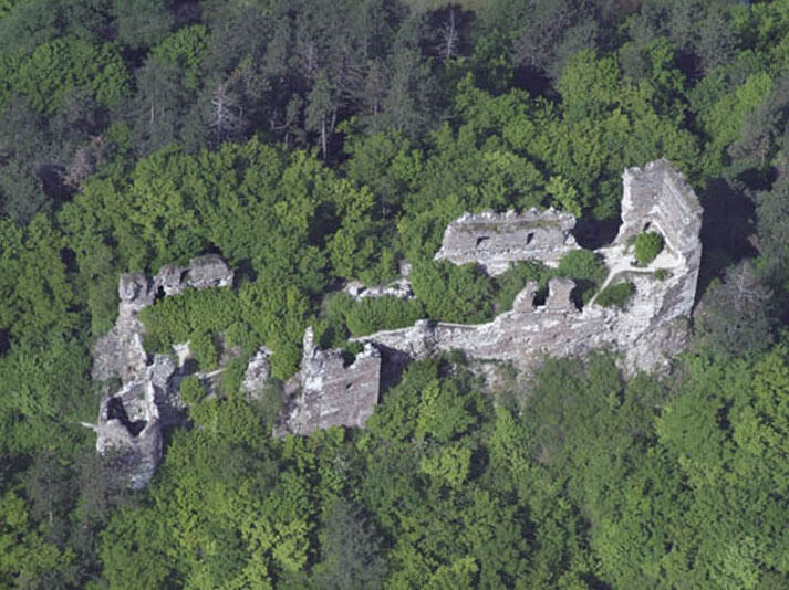
The castle was erected on an elongated rocky ridge lying between the Hron River in the east and a small stream flowing in a gorge in the west. Elongated roughly along the north-south line, the hill was characterized by rocky steep slopes, reaching 314 meters above sea level in the highest places. The slopes protected the building from three sides, only from the north, where the ridge was connected with the rest of the mountain massif, the slope of the terrain was lower. For this reason, a ditch was additionally dig on this short section. The castle garrison could be in visual contact with the watchtowers placed on the hills on the opposite side of Hron.
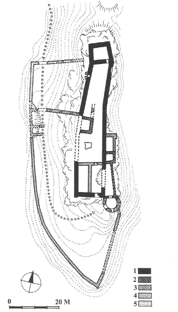
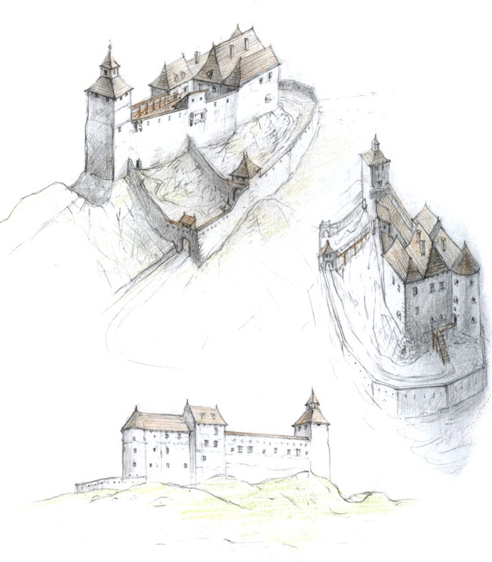
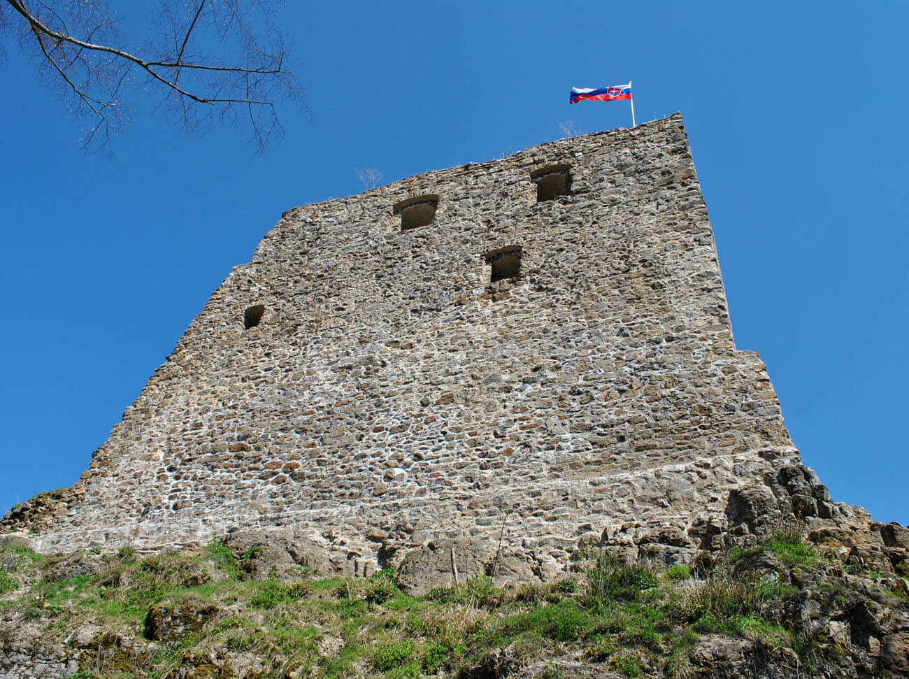
Initially, the castle consisted of a tower, located in the northern, highest part of the hill, and a small and narrow courtyard marked out by defensive walls, about 50 meters long, connected to the southern corners of the tower. The tower was erected on a quadrilateral plan measuring 8.5 x 9 meters, and the entire complex was about 60 meters long and 9 to 12 meters wide. The tower was initially not very high, only two-story, so it was not much higher than the crown of the adjacent walls, although it could have a wooden superstructure. The walls, built of unworked andesite, were about 1.5 meters thick and 8 meters high. On the offset, it had a wall-walk, secured with a parapet with crenellation, which 1.6 meter wide merlons were spaced approximately every 0.6 – 0.7 meters. The entrance to the castle led from the south, where it turned and at the foot of the rock ridge, and flanked by the walls of the long side of the castle, led north towards the gentler slopes. In the courtyard, a rainwater tank carved in the rock has functioned from the very beginning.
At the turn of the 30s and 40s of the 14th century, the four-sided tower was raised by one floor. Due to the insufficient living space inside, the southern part of the castle courtyard was filled with a three-story palace building, and due to its construction, the gate passage was moved to a better protected east side. In addition, the walls of the castle were strengthened and raised, especially the eastern curtain in the central part of the complex, at which a wooden porch was added to the outer façade, probably connected to the new residential buildings. The porch could not only have a defensive role as a hoarding, but it probably played a representative role with a view of the river, as the more endangered western curtain had only an open wall-walk with crenellation. During the expansion of the upper ward, a fortified outer bailey probably developed, located in front of the gate, on the south side of the castle. Due to the small amount of space in the narrow courtyard of the upper ward, the economic facilities of the castle had to be located there.
In the second half of the fourteenth century and at the beginning of the fifteenth century, the defense of the entrance to the upper ward was improved. The gate, moved to the eastern wall, was preceded by a small foregate, 12 meters long and 3 meters wide. This narrow passage led to a new, small, four-sided gatehouse, added to the outer, eastern façade of the castle on the edge of a rock slope, where it was hidden from enemy fire and difficult to capture due to the narrow foregate, dominated by the high walls of the upper ward palace. Then, in the next stage, the front, southern part of the foregate was equipped with a second four-sided gatehouse, facing directly to the outer bailey, while the older gatehouse was raised by two vaulted floors to a height of about 17 meters (thanks to which it surpassed the adjacent palace). The last stage of the late-Gothic extension of the gate was the addition of a short foregate to the southern gatehouse and the roofing of the entire gate passage.
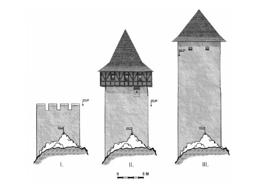
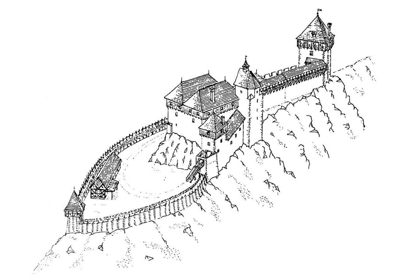
In the courtyard, the late-Gothic rebuilding led to the creation of an elongated, vaulted room in the vicinity of the water tank, added to the western curtain of the perimeter wall of the castle. There were probably more floors above this room, giving the building a tower-like form. In the late Gothic period, the northern main tower was once again raised, on which a latrine projection was placed on the additional floor from the north. After raising, the tower could again be crowned with a wooden or half-timbered floor with an extended defensive porch, covered with a tall pyramidal helmet.
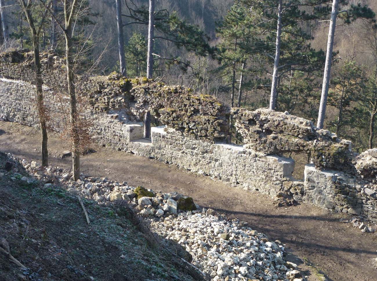
In the second quarter of the 16th century, due to the Turkish threat, a cylindrical, initially two-story tower was built, protecting the entrance from the outer bailey to the upper ward. It was adapted to the use of firearms, and its gate portal was set high enough that it could be equipped with a drawbridge accessible via a wooden ramp. The tower was crowned with a timber porch surrounding the upper storey. In the same period, a defensive wall of the outer bailey was also erected, connected to a cylindrical tower, ended in the south with an acute angle, and on the west side equipped with a corner gatehouse with a passage. The outer bailey wall surrounded the area with maximum dimensions of 71 x 30 meters. It was equipped in the ground floor with arrowslits, embedded in recesses splayed from the inside.
In the third quarter of the 16th century, a thorough reconstruction of the southern palace in the upper ward was carried out. New internal divisions were created, another storey was added, and the whole, together with the entrance part (original foregate), was roofed with three gable roofs, resulting in a two-wing L-shaped building. The facades of the building were pierced with large, late-Gothic windows with side seats and had latrine projections. To the north of the palace there was still a narrow, elongated courtyard, of defensive walls approached each other and ended with an early Gothic residential tower. During the extension from the 16th century, this narrow part of the courtyard was additionally reduced by rooms added to the northern wall of the tower-like building from the turn of the 14th and 15th centuries. It reached as far as the main tower, and from the west were equipped with a large bay window. On the south side, between this building and the main palace, there was a reduced courtyard measuring 12 x 9 meters.
Current state
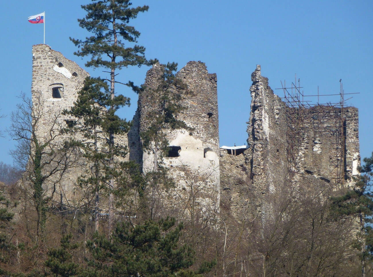
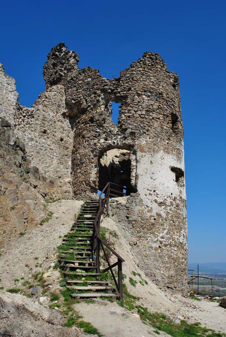
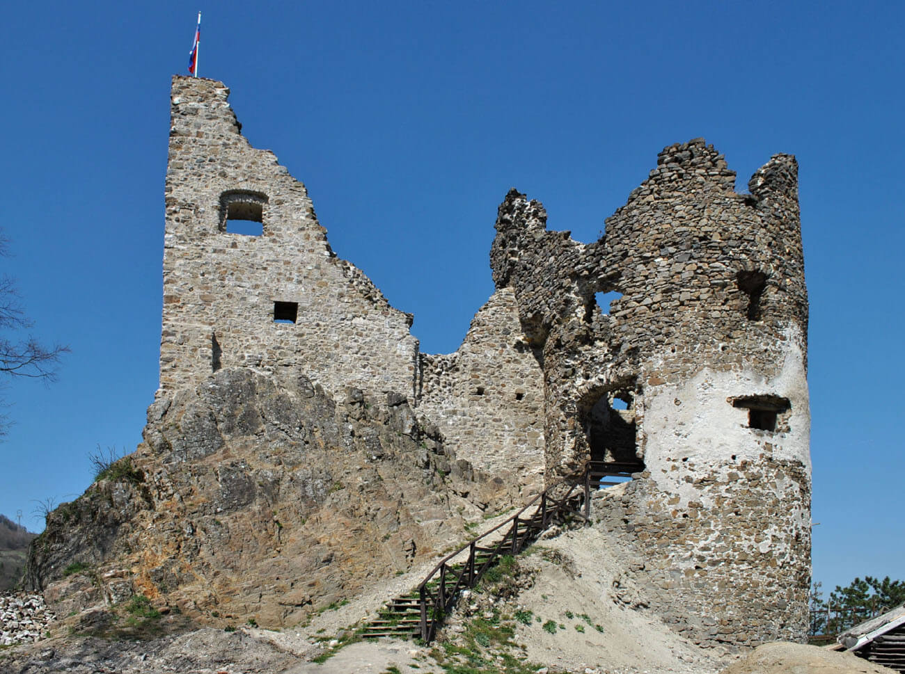
Today, the remains of the outer bailey are limited to relatively high defensive walls. The perimeter walls of the main residential house are visible in the upper ward, and the cylindrical tower is quite well preserved, with its highest storey dating back to the 17th century, as are the highest preserved parts of the walls of the main tower and the northern part of the eastern wing of the main palace (on the extension of the former foregate). The effect of early modern works are also the upper parts of the outer bailey walls with the upper row of loop holes, which were pierced after the older ones were bricked up in the ground floor, and the entire northern outer bailey. The early Gothic north tower and sections of the walls near it are the largest fragment of the ruins, and because they are in the highest place of the outcrop, they are also best visible from a distance. Unfortunately, in the 20th century, due to long-term neglect, significant sections of the walls collapsed. Not only parts from the early Renaissance period, but also late Gothic parts have been lost. Further degradation was stopped by the recent renovation and reconstruction works. Admission to the castle ruin is free.

bibliography:
Bóna M., Hrad Revište, Bratislava 2015.
Bóna M., Stredoveké hrady na strednom Pohroní, Nitra 2021.
Bóna M., Plaček M., Encyklopedie slovenských hradů, Praha 2007.
Stredoveké hrady na Slovensku. Život, kultúra, spoločnosť, red. D.Dvořáková, Bratislava 2017.
Wasielewski A., Zamki i zamczyska Słowacji, Białystok 2008.