
History
The town Podolínec was formed until 1296, when the Czech and Polish king Wenceslaus II granted it numerous privileges, including the right to build fortifications. In the fourteenth century, Podolínec additionally obtained the status of a free royal town with market and staple right, which favored the development of the town and the rapid enrichment of its inhabitants. Therefore, before 1382, the original timber and earth fortifications were rebuilt into stone defensive walls.
In 1409, the chancellor of Sigismund of Luxembourg, Imre Perényi, received a royal permission to build a castle in Podolínec. A small, stone castle stood very quickly, and a few dozen years later, the town and the castle successfully repulsed the attack of the Hussites. In 1412, Podolínec together with a dozen or so other towns of northern Spiš was included in the pledge of the Spiš and for 360 years belonged to Poland.
In the 90s of the 16th century, the castle was renovated under the command of the Spiš starost, Sebastian Lubomirski. It was not expanded and lost its military significance over time. After 1765, part of its defensive walls were dismantled. The main castle building was rebuilt at the end of the 16th or 17th century and it looked like a small palace. In the 19th century, most of the town walls were demolished.
Architecture
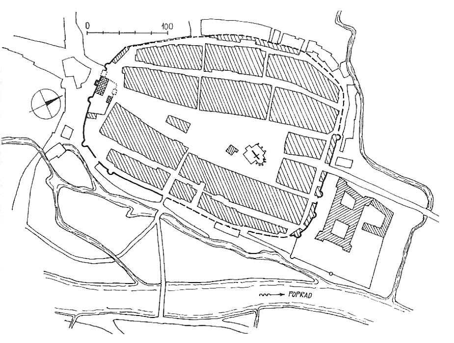
The town and the castle were founded on the northern bank of the Poprad River, with a mill channel under the fortifications, serving as a moat in the southern part of the circuit. The second, small watercourse flowing into the river encircled the castle and the town from the east and north-east sides.
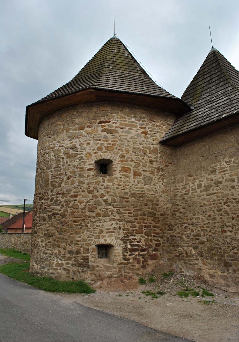
The town defensive walls were erected on a plan similar to an oval with a cut west corner. The wall was less than 10 meters high and was crowned with a defensive walkway covered with a breastwork in the form of a battlement. From the mid-sixteenth century, it was strengthened by several small, half-round, open from the inside towers. The outer defense zone was a moat fed with water from Poprad. Two gates led to the town: Upper and Lower, located on the extension of the main communication route running through the town on the north-south line. In addition, there were two smaller wicket gates.
The castle was incorporated on the south-eastern side into the town fortifications circuit. Its walls were added to the perimeter walls within the town, creating a trapezoidal shape in the plan. From the west, they were adjacent to one of the town gates. A large residential building stood inside them, and several other smaller buildings were added to the inner face of the walls. The residential building was two-story and had three rooms on the ground floor level. A four-sided tower, protruding from the perimeter towards the moat, was connected to the building from the outside (south side). It housed a staircase. The castle walls were 10 meters high, while their length was 263 meters. The entrance to the interior led through a four-sided, massive gate tower.
Current state
Currently, the castle which has lost all the medieval features, houses the town office. Out of its external defensive walls, only two sections have survived on both sides of the main building with a semicircular tower. The longest fragment of defensive walls has survived in the southern part of the town. Another preserved fragment of the town fortifications can be seen on the north-east side of the former circuit.

bibliography:
Bóna M., Plaček M., Encyklopedie slovenských hradů, Praha 2007.
Lexikon stredovekých miest na Slovensku, red. Štefánik M., Lukačka J., Bratislava 2010.
Mencl V., Stredoveka mesta na Slovensku, Bratislava 1938.
Wasielewski A., Zamki i zamczyska Słowacji, Białystok 2008.