

History
Kysak Castle was also called Somos and Drienov from the seat of the lords of Drienov from the powerful Aba family, who at the end of the 13th century owned the surrounding lands. In 1283, Petr of Drienov divided the property between his five sons, the eldest of whom George (Juraj) received the village of Kysak. He fought in the 80s of the thirteenth century against the Cumans and Tatars, and perhaps due to the desire to secure the lands against invaders, at the turn of the thirteenth and fourteenth centuries, with the help of his brothers Nicholas and Michael, erected the castle.
From 1304, Kysak was owned only by George’s sons, but often passed from hand to hand and was used by many members of the family, which often led to conflicts and further agreements, including regulating the division of buildings and property, issuing guards at the castle, or access to a water tank. Around 1368 the castle was renovated and rebuilt, which was mentioned in connection with the agreement between two branches of the Drienov family, while in 1378 there was a meeting in the castle with the lords of Brezovice regarding the distribution of ownership of the surrounding property.
Already in the first half of the fifteenth century, the branch of the descendants of George’s family died away, and the property was taken over by the neighbors from Žehna. Kysak was on the border of their estate, so they did not look after it, and eventually at the beginning of the 16th century the castle was abandoned.
Architecture
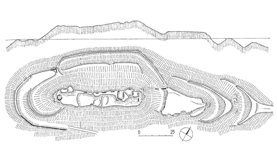
The castle was built on the top of a high hill, situated in the bend of the Hornad River, which surrounded it from the west and north, and at a slightly greater distance also from the east. There, steep slopes descended towards the valley, but they were even less accessible on the southern side, where a narrow and deep gorge separated the castle mountain from the next lower hill. Nature formed the mountain greatly elongating its shape on the east-west axis, which contributed to the characteristic form of the castle.
Kysak was up to 62 meters long. The width of the castle ranged only between 9 and 12.5 meters. It was protected by two transverse ditches, the larger, north-eastern one of which was 18 meters wide and had a rocky bottom at a depth of 10 meters from the edge of the castle hill. The second ditch with an earthen embankment surrounded the western part of the castle.
On the western edge a cylindrical tower (bergfried) with a diameter of 7.5 meters was erected, more or less in the central part a small building with a basement and another building and four-sided tower in the eastern part of the castle. Tower flanked the nearby gate, to which a timber bridge was led, over the ditch. All of the above buildings were connected by a stone defensive wall, which led along the edge of the slopes, separating a narrow and elongated courtyard, perhaps divided by transverse walls into smaller wards, inhabited due to the complex property situation of the castle by various branches of the family.
The western part of the castle was surrounded by a defensive wall, running along the entrance road, which surrounded the stronghold under the control of the cylindrical tower from the south to the northeast, where there had to be an entrance to the outer ward. It had a shape similar to a triangle, was protected by a ditch and separated from the castle core by the aforementioned transverse ditch, over which a wooden bridge was placed. The defensive walls of the outer ward were connected to the fortifications of the upper castle and, at the same time closed access to the ditch protecting it from both sides.
Current state
The castle has not survived to modern times. Traces of it are limited to the relics of the wall of a residential building and the hollow where the cylindrical tower was. You can reach the top of the hill with an unmarked, forest road from the village in about 30-40 minutes.
bibliography:
Bóna M., Plaček M., Encyklopedie slovenských hradů, Praha 2007.
Stredoveké hrady na Slovensku. Život, kultúra, spoločnosť, red. D.Dvořáková, Bratislava 2017.
Wasielewski A., Zamki i zamczyska Słowacji, Białystok 2008.