
History
Kežmarok received town rights (charter) along with the market and court privilege as early as 1269 from King Bela IV, and in an unknown period of the 14th century it was transformed into a free royal town. It was located close to the border, on the important trade route “Via Magna”, which connected the territory of Poland with Spiš region, therefore the construction of its fortifications was an important matter. The building of the defensive walls probably began in the second half of the fourteenth century, because the first reference to them appeared in 1368, in connection with the construction of the monastery building at the church of St. Elizabeth.
In 1404 king Sigismund of Luxembourg had to exempt the townspeople from taxes for 12 years due to damages caused by the fire, with the reservation that the income from six years would be used to build and renovate the fortifications. In 1433, the town walls did not provide protection against the Hussites who captured Kežmarok. After their departure, the fortifications were modernized, although initially the townspeople planned to completely dismantle the damaged walls, so that it do not become a place of support for other enemies. This was prevented by the intervention of king Sigismund of Luxemburg, who ordered the town to be fortified and secured again. At that time, the outer line of the lower wall and numerous towers were added.
In 1441, Kežmarok was occupied by the troops of Jan Jiskra, who fought in the service of Elizabeth, the widow of Albrecht Habsburg. His troops remained in the town until 1462, when an agreement was signed under which Jiskra gave Kežmarok to king Matthias Corvinus, who soon handed it over to the powerful Zápolya family. A few years later, they began the construction of a castle connected to the town fortifications, which entailed the need to demolish the church of St. Elizabeth.
In the 17th century, the medieval fortifications were already heavily dilapidated, and the last time they were used during the battles of the imperial army with kurucs rebels in 1709. In the following years of the eighteenth century, destroyed by fires and unrepaired, they were left until the demolition works in the nineteenth century.
Architecture
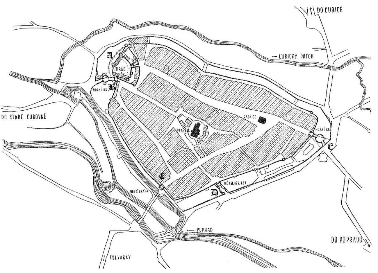
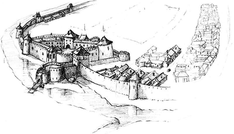
Kežmarok had a shape similar to a triangle with the northern corner occupied by the castle since the mid-15th century, and earlier by the church of St. Elizabeth. It enclosed an area of about 20.5 ha. The town was situated in the fork of the Poprad river flowing on the west side (spilled into three branches) and the smaller Lubicky stream which connected with it in the north and surrounded the town from the east. Stream supplied waters to the town moat, created in the eastern, southern and south-western sections.
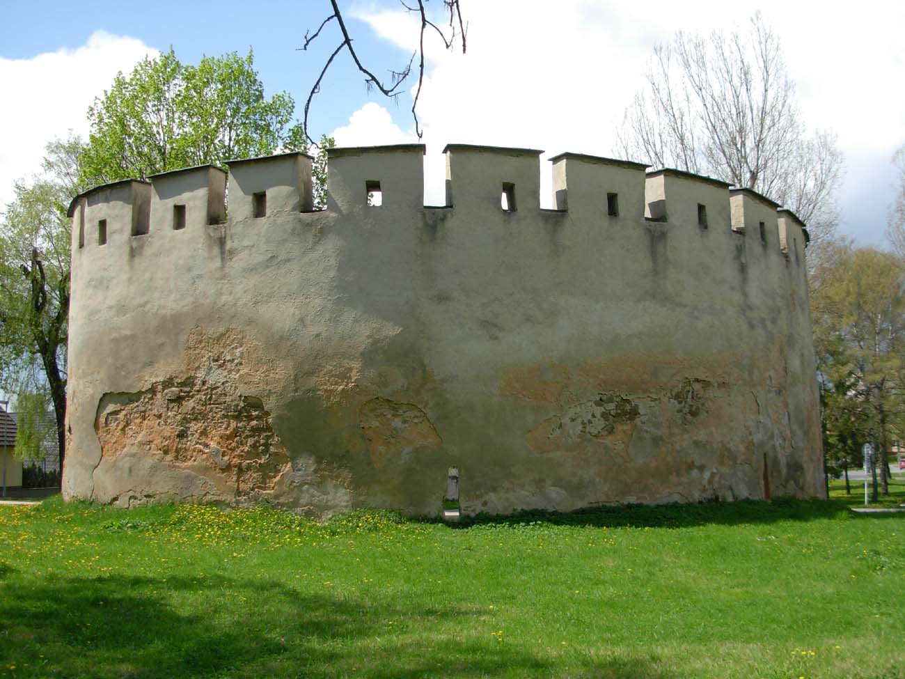
The defensive walls were built of erratic stones. Their length was about 2,000 meters, about 5 meters high and 1.5 to 2 meters thick. They had slits, and from the town side there was a guards wall-walk. In the fifteenth century, they were strengthened with towers: about ten semicircular towers of various sizes, open from the town side, and four full four-sided ones located in the southern and south-western part of the circuit. In addition, a lower external wall was also erected, which, however, did not cover the entire town, but only the most endangered south and east side, surrounding the castle in the north. It was also not a typical zwinger wall, as it was on the outer side of the moat, 20-25 meters wide, securing the approach to it. The town walls were coupled with the fortifications of the Kieżmark castle.
An important role in the defense of Kežmarok was also played by the stone burgher houses built in the 13th century, before the defensive walls, in the form of residential towers houses. The most massive ones were located along the oldest road leading from the Upper Gate to the ford, while the slightly smaller tower structures were located in the Old Market Square, where before the town’s foundation there was a fishermen’s settlement, and later the oldest center of the medieval town with the parish church of Holy Cross.
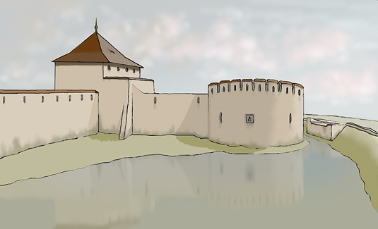
Three gates led to the town: Furriers Gate in the south-west, High Gate (Upper Gate) on the south and Lower Gate, also called Polish Gate, in the northern part of the town, right next to the fortifications of the castle. In addition, in the north-west part, a less important, pentagonal New Gate was built, facing the Poprad, but it was not the original one, but was rebuilt from a town tower. In had the gate passage, and it also housed a prison. The main gates at the end of the Middle Ages were reinforced with front foregates and barbicans.
The Furriers Gate complex finally reached a length of about 60 meters, consisting of the gate tower and the foregate building connected to it, which was preceded by a neck ending with a round barbican with a drawbridge. The Upper Gate was placed in a four-sided tower, about 17 meters long, with a passage in the ground floor, connected by a neck with a circular barbican, entirely located in the center of the moat. The entrance to it was placed at an angle and provided with a drawbridge. In the gate tower, there was to be a weapons and ammunition warehouse, located, among others, in a vaulted cellar measuring 12.5 x 6.5 meters. The Lower Gate also consisted of a four-sided tower with a passage, connected on one side with the curtain of the town wall, and on the opposite side with the castle wall and the wall of its zwinger. From the front side, a neck ran out of the tower, connected to a circular barbican, located, similarly to the two previous gate complexes, in the middle of the moat and equipped with an entrance at an angle that facilitates defense. The barbican of the Lower Gate has a diameter of 22 meters and a drawbridge, originally of wooden construction.
Current state
Only a part of the barbican of the old Lower Gate and modest fragments of fortifications have survived to the present day, mainly in the southern part of the city at Bastova street and a tower in the south-eastern part of the circuit.
bibliography:
Lexikon stredovekých miest na Slovensku, red. Štefánik M., Lukačka J., Bratislava 2010.
Mencl V., Stredoveka mesta na Slovensku, Bratislava 1938.
Sypek A., Sypek.R., Zamki i obiekty warowne Słowacji Wschodniej, Warszawa 2005.
Website kezmarok-sk.szm.com, 0pevnenie mesta Kežmarku.