
History
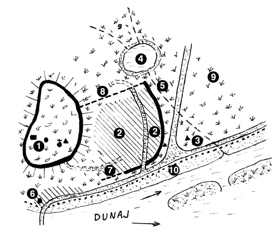
The beginnings of Bratislava fortifications can be associated with the 4th century BC, when the Celtic Boi tribe settled here. They built a defensive settlement (the so-called oppidum) with an area of about 100 ha, connected with a smaller economic settlement about 600 meters away and another center in Devín. The latter took over the function of the Bratislava oppidum after its destruction by the Daks around 55-54 BC. In the Roman period, legions were stationed only on the later castle hill, forming part of the fortifications of the empire border, Limes Romanus. Re-colonization of the area of the later town took place in the 7th century by the Slavic population, from the end of the 8th century being part of the Duchy of Nitra, and then in the 9th century the Great Moravian state, when a settlement developed, dependent on the vast Slavic hillfort located on the castle hill.
Bratislava (“Brezalauspurc”) was first recorded in 907, during the decay of the Great Moravian state, on the occasion of the battle between Bavaria and Hungary. At the turn of 10th and 11th century it was already a Hungarian border, castle and craft settlement. The first market was recorded in 1115 during the rule of Stephen I, and soon after the collection of customs duties was mentioned for the first time. The defense of the settlement at that time was most likely provided by wood and earth fortifications. From the end of the 12th century, it developed quickly, among others due to colonists from the Bavarian area, with a short slowdown after 1241, associated with the great Mongol invasion. However the castle fortifications and the settlement had to be strong enough, that neither the borough or the stronghold on the hill were captured. Their strength was also demonstrated by the transfer of the chapter from the castle area to the settlement in 1221, as this translocation would not have been carried out if the Bratislava fortifications were considered too weak.
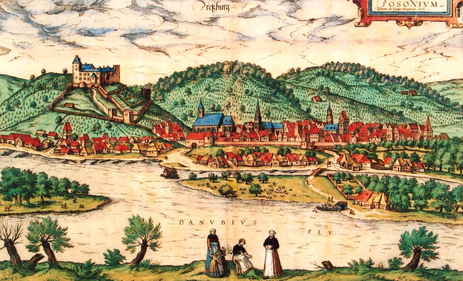
In the first half of the 13th century Bratislava (then known under the Slavic name Prešpork, German Pressburg and Hungarian Pozsóny) received a foundation privilege. At that time it was already an developed early Gothic organism with the features of the town, which it was decided to provide with stronger fortifications. This decision was also probably influenced by the Mongol invasion and fear of subsequent attacks, against which the Hungarian ruler Bela IV wanted to better secure his kingdom. Therefore, at the beginning of the second half of the thirteenth century, stone defensive walls were built, but they did not yet surround the entire town, but defended the most vulnerable north and north-east side. They were destroyed quite quickly, because during the battles of the King Ottokar II of Bohemia with Austrian Albrecht. In the 1270s, the town and the castle were conquered twice, in 1286 Prešpork took the rebel palatine Mikuláš from Kysak, and then the Austrian Albrecht, which in 1291 was banished by the Trenčín zupan, Matthew III Csák.
After normalizing the situation, in 1291 new opportunities for development gave the town the privilege of the Hungarian king Andrew III. In the sphere of defense, this contributed to the rebuilding of the town walls. At the same time, a north-west section was erected towards Vydricá, and at the beginning of the 14th century the southern wall from the Danube side. In 1314 towers were mentioned for the first time in written sources, when the knight James financed the construction of two of them. Their construction was probably associated with increasing the town’s defenses during internal conflicts between the new Anjou dynasty rulers, Charles Robert, and the rebellious oligarchs (especially Matthew Csák). At the end of the fourteenth century, the fortifications were reinforced with the second perimeter of the lower, outer wall.

In 1421 and 1423 the town experienced the invasion of the Hussites, but before the first attack the fortifications were strengthened, among others by creating earth fortifications and palisades in the suburbs. Despite the fact that the invasions were not successful, and in 1424 Jan Žižka, a great leader and strategist of Taborites died, the Hussite threat did not decrease in subsequent years. That is why in 1427 King Sigismund of Luxembourg ordered the repairs and strengthening of the town and castle fortifications, and called the nobility of the Prešpork County to help the townspeople during fortifications. These actions were taken on time, because in 1429 the Hussites, led by Prokop the Great, approached the town, burned the suburbs, but did not capture the main fortifications. Another attempt to conquere was made in 1432 by the Hussites from nearby Trnava, who, together with the inhabitants of Prešpork supporting Hussism, were to take the gate of Laurentius and let in enemy troops at night. However, this conspiracy revealed, and its participants were imprisoned and executed.
When Sigismund of Luxembourg died in 1437, the fight for the crown began in Hungary, and there were numerous plunderers and post-Hussite bands in the country. For this reason, the townspeople again renovated the fortifications (especially ditches), and erected barbicans in front of the gates of Michael and Laurentius. New towers adapted to the use of firearms were also built (e.g. Bakery, Shoemaker). In 1455, the Vydricá Gate was rebuilt, then a massive Powder Tower was erected by the end of the 15th century.
In 1526, the Turks defeated the Hungarian army near Mohacz, in 1529 they captured Buda and moved the borders north. This mobilized the townspeople of Prešpork to renovate fortifications, especially the moats filled with waste and debris, and to further modernize the fortifications by adapting them to the changing war technique (bricking up the battlement, piercing the loop holes for firearms, and the Fisherman’s Gate was walled, despite the narrow pedestrian wicket gate). These works were carried out on time, as in 1529 the Turks undertook the unsuccessful siege of the town. Despite effective resistance, in 1530 the state authorities ordered the demolition of the churches of St. Michael, St. Laurentius, St. Nicholas and two hospitals, to prevent opponents from fortified in it. The town was also strengthened by a numerous garrison, which in 1532 repelled another Turkish siege.
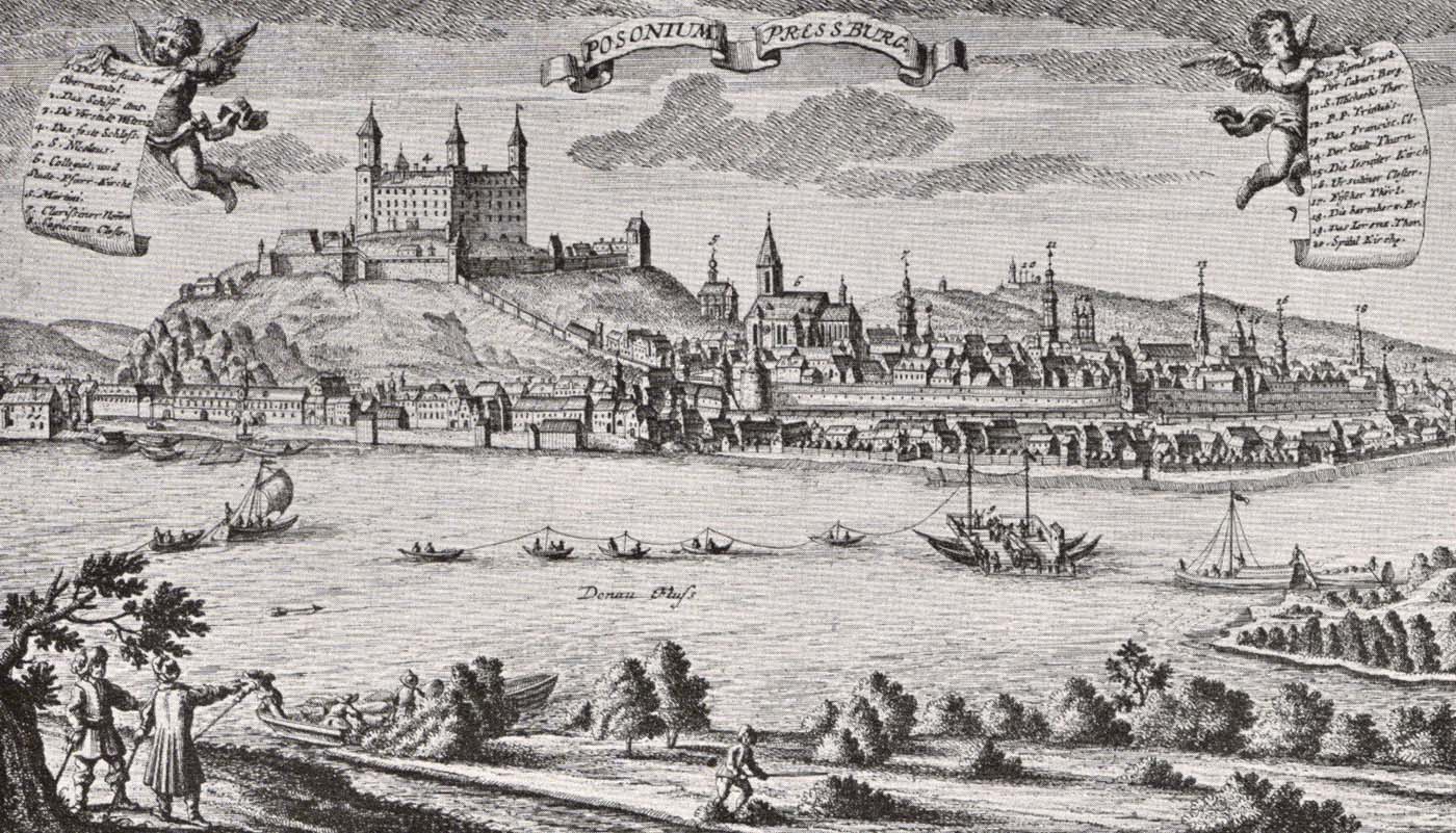
From 1563, Prešpork (Bratislava) became the crown town of the Hungarian Kingdom ruled by the Habsburgs, to which numerous offices and institutions were transferred. The town also became barracks for numerous soldiers quartering around the houses of the burghers and the suburbs. A strong garrison, despite the weakening of the Turkish threat at the end of the 16th century, was maintained for a long time, because in the next century Hungary entered the period of numerous anti-Habsburg uprisings and internal fighting. During them, the town changed from hands to hand. In 1606, it was occupied by Stefan Bocskay’s troops, in 1619 by the army of Gábor Bethlen, and a year later by the imperial army. The devastation was completed by two town fires: from 1642 and 1647. In the second half of the 18th century, the medieval fortifications destroyed by fighting and natural disasters lost their importance, therefore, due to the renewed increase of the Turkish threat, the construction of early modern bastion fortifications began at that time. In 1704 Bratislava defended itself against the insurgents of Francis Rákóczi, but several dozen years later the old fortifications were considered too archaic and did not meet the requirements of the then martial art. Maria Theresa allowed their demolition, which began after 1770.
Architecture
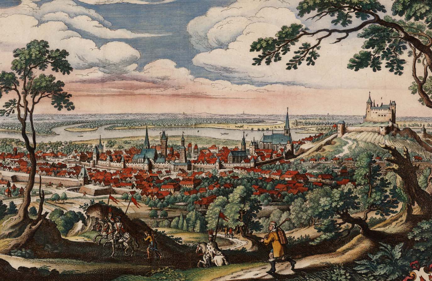
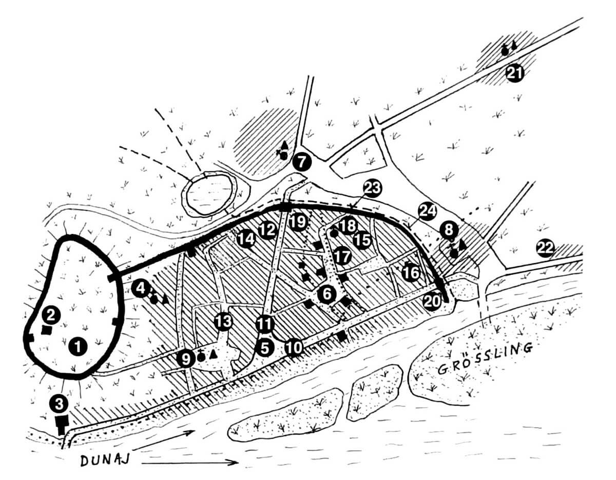
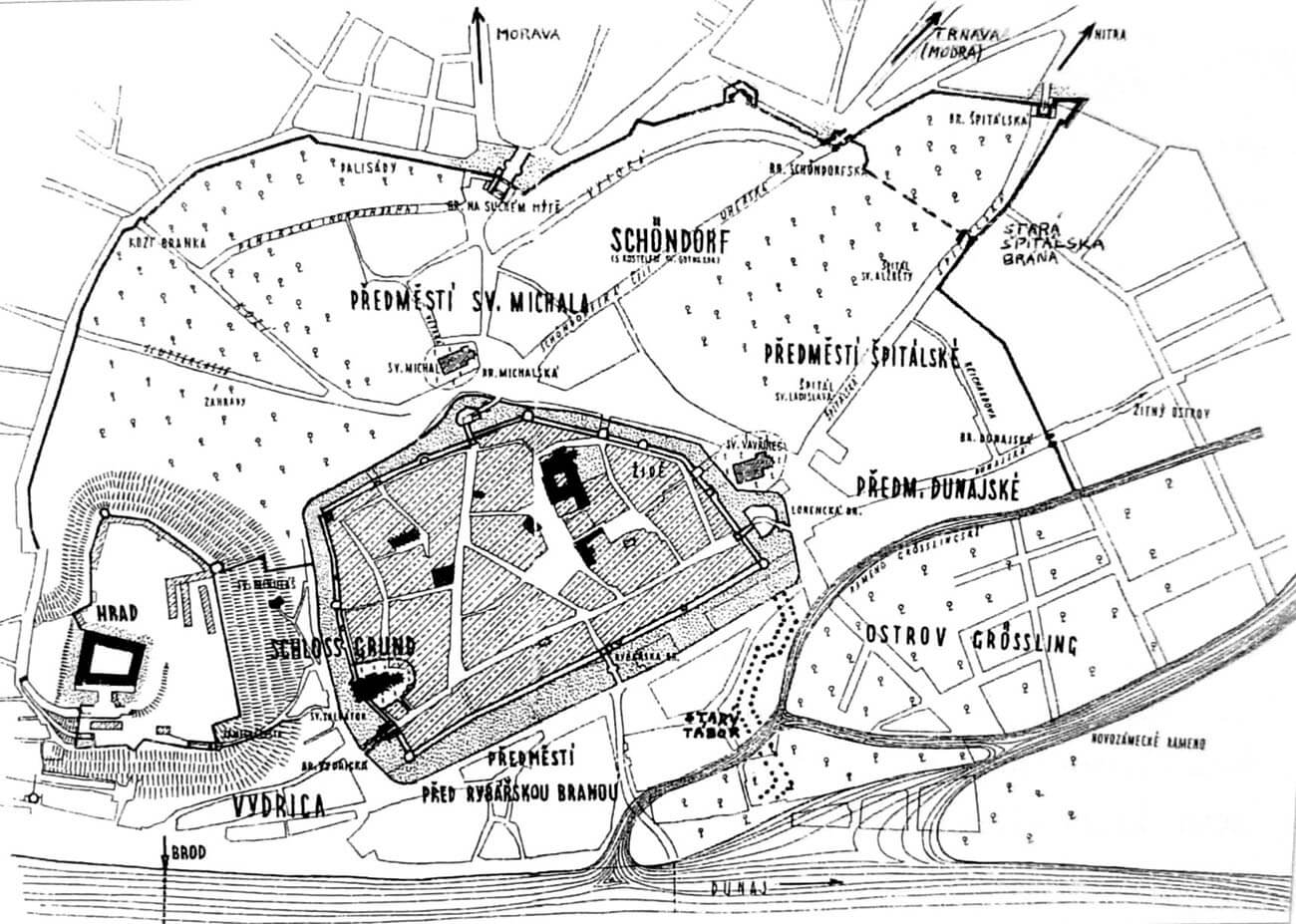
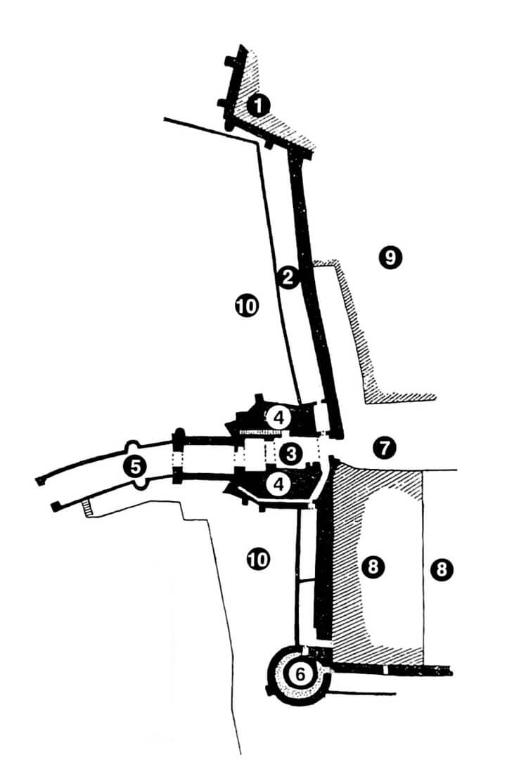
The fortifications of Bratislava were built on an elongated polygon plan with the longest, straight curtain located parallel to the Danube River. From the west, the town bordered the castle hill, while from the east with wetlands and islets formed by the arms of the Danube. Therefore, in the second half of the 13th century, the northern and north-eastern parts of the town were the first to be secured by a single line of the wall, running from the castle to the east to the Michael’s Gate, from where they turned the arch towards the river.
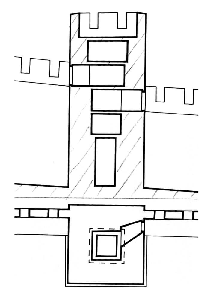
The wall from the 13th century was built of unworked erratic stones bound with lime mortar. Its height and thickness are not known, but it was probably similar in dimensions to the castle wall from that period and topped with a battlement protecting the wall-walk for defenders. There were several towers along the line of the wall, probably located within the effective range of the archery shot. The shape and size of most of the towers is unknown, but the only one which relics survived was in the shape of a square with dimensions 6.3 x 6.3 meters. The entrance to it led from the height of the defensive wall at the level of the second floor. This tower exceeded the wall by two storeys, and its floors were separated by timber, flat ceilings. The top of the tower was in the form of a battlement.
In the mid-thirteenth century, the town did not have its own fortifications from the west, it was protected in this direction only by the fortifications of the castle hill and by the so-called Water Tower located below it, at Danube ford. It served as a watchtower at the toll point and the western town gate. In 1252 it was expanded to form a stronghold with a massive octagonal tower in the southern part of the perimeter wall.
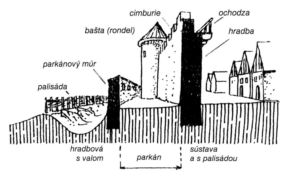
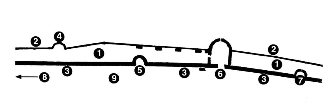
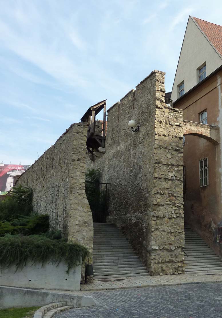
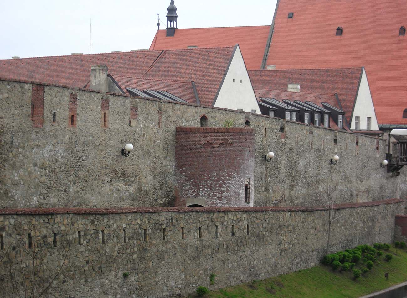
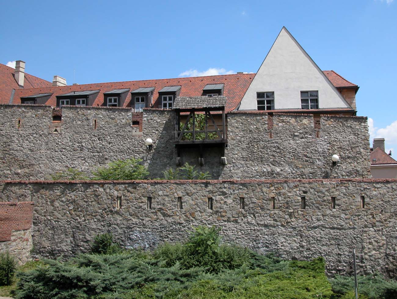
The defensive walls after the reconstruction at the turn of the thirteenth and fourteenth century already surrounded the entire town. They were 2 meters thick in the ground floor, while they narrowed to about 1.3 – 1.6 meters in upper parts. Like the older fortifications, they were built of medium-sized unworked stones, perfectly matched and combined with mortar. The height of the wall from the town side was above 6 meters, while the maximum height of the wall from the field side reached about 8-10 meters. As the wall in the upper part narrowed considerably, the defenders’ wall-walk was extended by a wooden porch supported by stone corbels. Initially, the porch was open, but later during the development of firearms it gained a roof to protect against the weather. As you can see in the old vedutas, this process was slow and the exchange of the crowning of the walls proceeded in stages. At the end of the 16th century, long sections had a battlement instead of loop holes adapted for the use of firearms. Corbels were also placed on the external façades of the wall, but here they supported box machicolations, small projections enabling fire down, at the base, while protecting against enemy fire. Such projections, when adjacent to the moat, could also be used as latrines.
From the field side, the fortifications were preceded by a ditch, while from the side of the town, a circumferential street ran around the perimeter of the walls, enabling quick movement of defenders and sending supplies, ammunition, weapons, etc. However, often the rear parts of houses almost came into contact with fortifications, sometimes allowing the transition from the roof to the crown of walls. The owners of such tenement houses were obliged to inspect and take care of nearby fragments of fortifications, and all damages, especially of impermanent wooden parts (porches, stairs, box machicolations) had to be reported to town officials.
The wall of the outer perimeter, erected at the end of the 14th century, was half the height and slightly thinner than the main ring of fortifications. Its thickness was 1 meter in the groun foor and from 0.6 to 0.8 meters in higher parts. The height oscillated around 5 meters, but like the main wall it was initially crowned with a battlement. It created a zwinger (inter-wall) area about 3.5 meters wide between the older wall. In front of it, however, a new moat was dug 6 meters deep and an earth rampart was built.
The towers of the main perimeter of the fortifications had various forms since the 14th century: initially they were small semi-circular, open from the town side, then also cylindrical and quadrilateral with a closed form, and the latest were large horseshoe towers covering the entire zwinger space and protruding even in front of the outer wall. The towers were fairly evenly distributed around the perimeter, except for the safest south side facing the Danube. The distances between the towers had to be close enough to allow effective fire from crossbows and later from the first handguns. Initially, the towers were crowned with a battlement to protect against arrows and belts, later on from the 15th century battlements were walled up and loop holes adapted for guns were created, and roofing was erected.
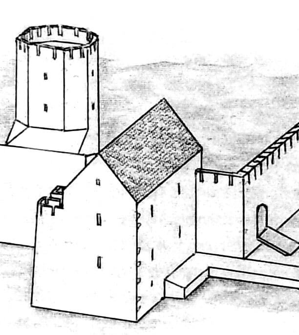
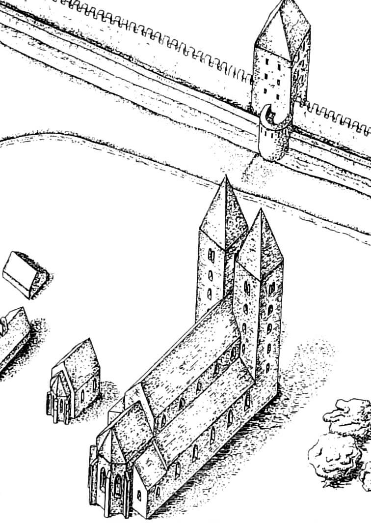
Tower of the cathedral of St. Martin also served as a defensive tower. It was added around the mid-fourteenth century, and from the beginning it was intended for defensive purposes. The church was erected towards the ditch by the west facade. In 1445, for better protection, an additional defensive timber work was built in front of it.
In the 15th century, north of the cathedral, there was a tower of the outer defensive wall called Ungerfeind or School Tower, because it was located near the chapter school. It had a semi-circular form and was open from the inside. Next it was the half-round tower of the main wall called Luginsland (one of the castle towers had the same name), erected shortly before 1440. The most massive tower of the western section of the perimeter was, however, the horseshoe Birds Tower, attached to the face of the main wall but protruding up in front of the outer wall. It was built in the fourteenth century, but in 1373 and again in the fifteenth century was rebuilt to adapt to the use of firearms. The entrance to it led through wooden stairs from the side of the underwall street, two portals from the crown of the main defensive wall and another gate from the zwinger area. After the reconstruction, it had three floors above the defensive walls, and on the field side, facing the ditch, additional wooden and earth fortifications called Hell were created. Behind the Bird Tower there was another half-tower, while in the north-west corner of the fortifications the abovementioned four-sided tower was built in the mid-thirteenth century.
The northern section of the fortifications was reinforced with a small half-tower At the Wide Stairs and a tower next to it called At the Upper Baths. The section behind the Michael’s Gate running a slight arch to the south-east was protected by a massive Powder Tower of a similar construction as the Bird Tower. Behind it was the half-tower Behind the Monastery, first mentioned in 1498. A little earlier, in 1450 Jewish Tower was mentioned, in the form of a large building adapted for the use of firearms. The next was a half-tower of the outer wall called the New Tower, mentioned for the first time in 1473, while the last tower of the eastern fragment was the Butcher’s Tower of a square-shaped form. The southern part of the town was much less protected by towers due to neighboring with the Danube. There were only two corner towers. Bakery Tower flanked the Laurentius Gate. It was cylindrical, and to improve defense, wooden and earth fortifications called Old Tabor were built in front of it. In the western corner the Shoemaker’s Tower was flanking the nearby Vydricá Gate. It had a cylindrical shape and was preceded by fortifications called Vydricá Tabor.
Four gates led to the town, three of them overlooking the main trade routes and towards the ford on the Danube, while the fourth, less important was facing south, towards the Danube and its branches. The Michael’s Gate (Michalská) from the 13th century was located from the north, the 13th-century Laurentius Gate (Laurinská) was located on the east side, and the Vydrická Gate was erected from the west in the 14th century. In the fifteenth century, the southern Fisherman’s Gate (Rybárska), mentioned less important, leading towards the river, was built.
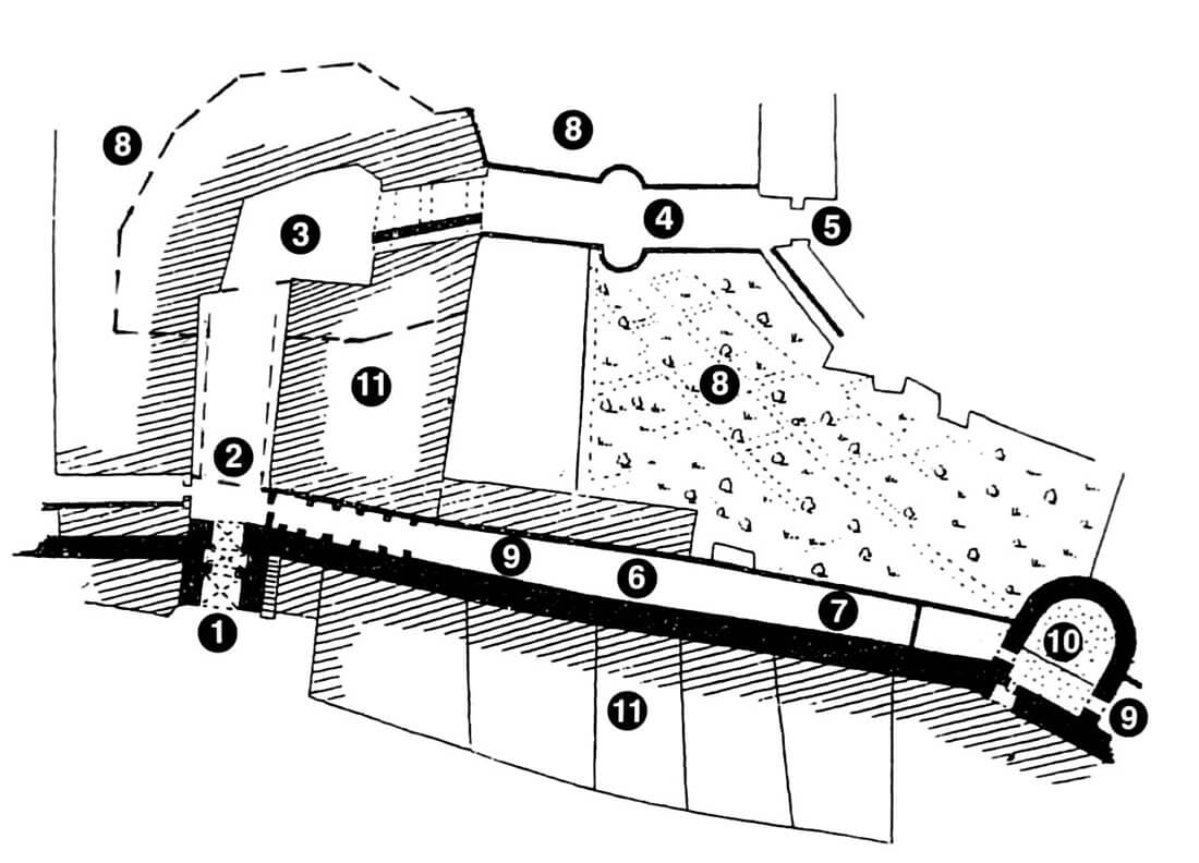
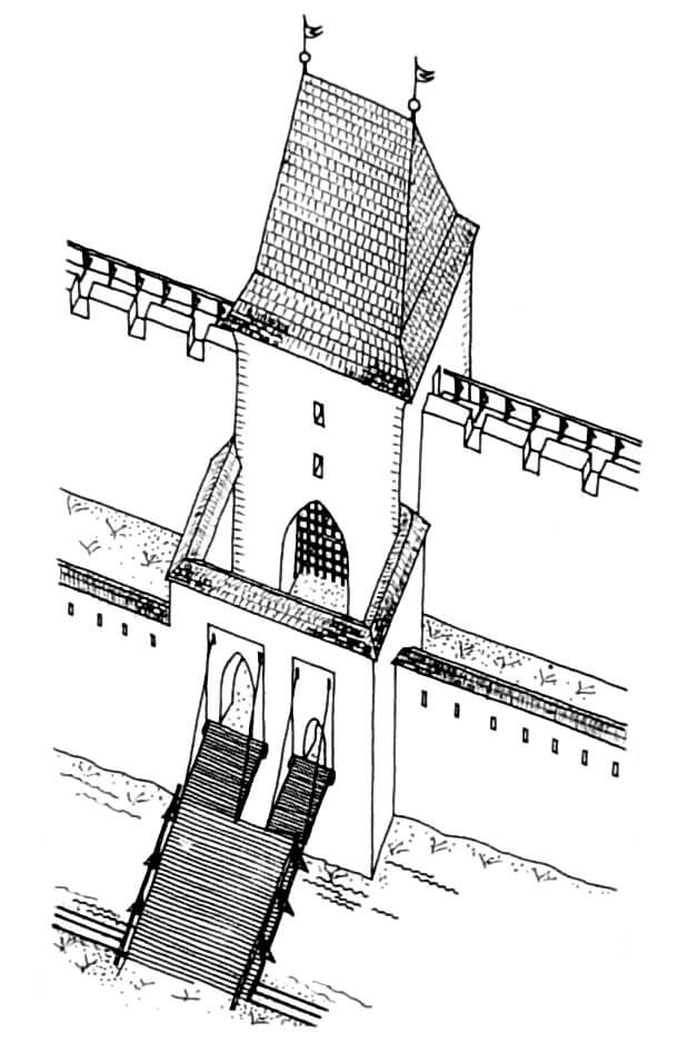
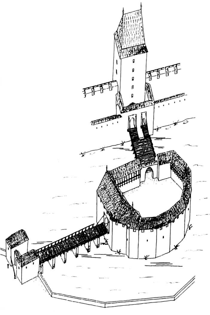
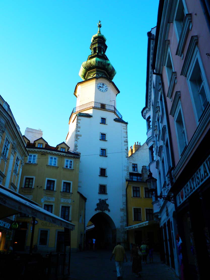
The Michael’s Gate was named after the nearby church of St. Michael. Originally, it was a gatehouse on a quadrangle plan, only one storey higher than the crown of the defensive wall and topped with a hip ridge roof (the tower was raised three floors in 1530). In the ground floor there was a vaulted gateway with an ogival portal closed with a portcullis and a drawbridge. Behind the it an additional protection was a wooden gate with iron fittings. The entrance to the tower led through the portal on the first floor on the east side. You could also enter from the porch in the crown of the walls, from both sides of the gate tower, which means that it was transitive. At the end of the fourteenth century, when the outer ring of the wall was erected, the gate was extended by a straight foregate with a larger opening for horse riders and a smaller pedestrian gate. Both were preceded by drawbridges over the new ditch. In the mid-15th century a barbican was built in front of the foregate – a polygonal defensive work erected from large stone blocks bonded with lime mortar and bricks in the upper parts. Its walls were 2.6 meters thick in the ground floor and about 1 meter thick at the height of the first floor. As the barbican was located in a former ditch, its height was only equal to the defensive walls. Above it was topped with a roofed defensive walkway. The outer gate was situated at a right angle to the inner gate, i.e. parallel to the curtain of the defensive wall, from which side fire could be shoot to entering attackers. The latter was additionally preceded by a drawbridge.
The eastern Laurentius Gate also owed its name to the church, located outside the town walls. Initially, it had the form of a four-sided gatehouse, similar in appearance to the Michael’s Gate. In the mid-15th century, it was also preceded by a barbican with a drawbridge and a slanting entrance. At the turn of the 15th and 16th centuries, it was raised by installing an additional storey with a stone defensive gallery and four bartizans in the corners. At the time, the lower storey contained ammunition, gunpowder and cannon balls, as well as a room for the guard, while the basement chamber was to contain a heavy municipal prison. Apparently, due to a slightly lower location than other gates, the Laurentius Gate was often surrounded by piles of mud.
The Vydricá Gate was directed to the ford of the Danube and the settlement of Vydricá, to which it owed its name. Initially, it was a four-sided gatehouse with a passage in the ground floor. In 1455 it was rebuilt: the facades were decorated with squares, and on the sides were placed two towers, named after the founders: Himmelreich and Leonfelder. The gate’s passage was also extended by the foregate’s neck, which meant that its interior became very dark and the gate received the additional name of Dark or Black Tower.
The youngest, smallest and least important Fisherman’s Gate owed its name to the road leading to the coastal areas of the Danube, initially rarely built up only by fishermen’s huts, and then by settlements of tanners and butchers. Originally it was an ordinary gate in the wall, transformed into a four-sided gatehouse at the beginning of the 15th century, and then preceded by a foregate. Both parts were equipped with drawbridges, and the gate tower was additionally equipped with a portcullis. In the mid-15th century, the outer corners of the foregate were equipped with two semi-circular small towers with a diameter of 1.8 meters.

The outer zone of the town’s defense were always ditches and moats. Since the end of the fourteenth century, the ditch had a depth of about 6 meters with slopes forming a 45-degree angle, lined with wood and reinforced by stone retaining walls. Its bottom was rounded, about 15 meters wide. Some of the ditches were dry, while some formed irrigated moats. The latter were located on the southern side of the perimeter, from where they were fed with river waters. On the north side, the ditch was dry (survived references to its use as a shooting range), although it is believed that it was periodically filled with water from an artificial lake or nearby streams. On some sections, the ditches were preceded by clay – earth ramparts, 2-3 meters high.
The period of the Hussite wars and military changes that occurred at that time, related in particular to the development of firearms, forced the burghers to quickly build some makeshift fortifications in the foreground of stone fortifications. They were around the three southern gates: Vydricá, Fisherman’s Gate and Laurentius Gate, due to the retraction of the Danube shoreline and drainage of riverside areas in the 15th century, which were considered too poorly protected. South of the Bakery Tower, around 1439, the so-called Old Tabor was created, on the southern side of the Fisherman’s Gate, Lower or New Tabor was erected before 1434, and at the Shoemaker‘s Tower and the Vydricá Gate the so-called White Tabor, recorded in 1440. Each consisted of a ditch, an earth rampart and a timber palisade mounted on it. The ramparts were reinforced with wood, sometimes with stones, bricks or clay. A little later (the first mention in 1442), Tabor Behind the Tannery was created, protecting the Danube bank south of the Shoemaker‘sTower. Its fortifications were equipped with a drawbridge leading to the fishing village of New Settlement, while a pedestrian bridge led to Vydricá.
Current state
Up to the present day have survived the Michael’s Gate and a fragment of fortifications near the cathedral of St. Martin, discovered among modern buildings after 1960. A short fragment of the wall embedded in the modern buildings can be seen on Nedbalova Street, you can also find a fragment of the Vydricá Gate wall. At the Michael’s Gate there is now a Museum of Weapons and Defensive Walls.
bibliography:
Baxa P., Ferus V., Bratislava mešťana Wocha, Bratislava 1991.
Hanak J., Kopuncova B., Prešporské opevnenia, Bratislava 2017.
Mencl V., Stredoveka mesta na Slovensku, Bratislava 1938.