
History
Svätý Jur Castle (Hungarian: Szentgyögy), later known as Biely Kameň, was owned by a powerful family from Svätý Jur and Pezinok until their extinction in 1543. In 1209, King Andrew II granted the settlement of Svätý Jur to a certain Sebeš of the Hont-Poznan (Hungarian: Hont-Pázmány) family, who founded the first modest residential and defensive seat nearby. When he was killed in 1241 in a battle with the Mongols on the Slana River, his only son Abraham inherited the village and its surrounding estates. The original residence may have survived the Mongol invasion, but by the second half of the 13th century, it no longer met the requirements for effective defense. The reconstruction into a stone castle became necessary, especially due to its border location in the southern part of the Little Carpathians, at the border of the Kingdom of Hungary with Austria and Bohemia. Abraham decided to build his new residence around the 1260s. Construction work likely began after 1262, as at that time Abraham had already pledged his estate with the settlement of Svätý Jur as collateral for a property agreement. This document does not mention the castle, and it is unlikely that Abraham began construction of his residence on the pledged property.
“Castrum Sancti Georgii” was first recorded in 1271, in connection with the war against King Přemysl Otakar II. He invaded Hungarian lands with a Czech army, reinforced by Austrians, Moravians, and Brandenburgers. He crossed the Morava River, captured Bratislava, and then, during his march on Trnava and Nitra, captured Pezinok Castle, Červený Kameň, and Biely Kameň. The Czech garrisons held out for only six to seven weeks, but Biely Kameň was captured again in 1273. This time, it was occupied by forces from Vienna and the New Town of Vienna, during the chaos that erupted after another invasion of Hungary by Přemysl Otakar II. The castle was besieged once again in 1287, when it was captured by the forces of the Austrian Prince Albrecht I Habsburg, under the pretext of providing neighborly aid and strengthening the western border of the Kingdom of Hungary. Albrecht withdrew from Hungarian territory only in the summer of 1291, after signing the Treaty of Hainburg. The lords of Svätý Jur managed to reclaim their residences somewhat earlier, thanks to the actions of Ladislav of Čeklís, who received the Dolný Štál estate from Count Pavol II of Pezinok for his military achievements.
Biely Kameň was not frequently recorded in the 14th century. From 1324 to 1328, the castle’s castellan was Ján of Šulian, a close relative of Count Petr I of Svätý Jur. Following the division of the estate between the brothers Sebeš II and Petr in 1343, the Svätý Jur estate, along with Biely Kameň, ultimately passed to the younger Petr. Count Petr, and at the latest his sons, Ján, Petr, and Tomáš, rebuilt their residence in the second half of the 14th century, particularly expanding the upper ward. Perhaps thanks to these transformations, Biely Kameň was described in 1361 as “castrum satis pulchrum est constructum.” During the struggle for the throne that followed the extinction of the Anjou dynasty, the forces of the Moravian margraves Prokop and Jošt captured the territory almost to the Váh River in the summer and autumn of 1385, on behalf of the new candidate for the Hungarian throne, Sigismund of Luxembourg. According to the chronicler Eberhard Windecke, Svätý Jur and Pezinok were among the castles occupied at that time. Their rightful owners regained them around 1390, after the military occupation ended and a ransom was paid.
At the beginning of the 15th century, the castle’s owners split into two branches: those of Svätý Jur and of Pezinok. As a result, the oldest castle survey was created in 1412 to address property disputes. This inventory indicated that the upper ward already had buildings on at least the northern and southern sides of the courtyard, a gate tower, and a main residential tower. The fortifications were strong enough that during the turbulent period of the Hussite Wars and subsequent power struggles of the 1440s, the castle apparently escaped capture. This was despite the fact that the town below Svätý Jur was captured in 1428, 1434, and 1441. In 1446, the Biely Kameň passed to Count Juraj III of Pezinok, who likely led construction work on the castle until his death in 1467. These may have been related to the modernization of the fortifications, as firearms were first recorded in it in 1466.
In the second half of the 15th century, Biely Kameň began to decline in importance, partly due to the transfer of the family’s main seat to Óvár Castle after 1441. In 1543, the Counts of Svätý Jur and Pezinok died out. Their estate was seized by the King, who sold it to the Upper Hungarian captain, Gašpar I of Seredna. The new owner did not use the castle as his permanent residence but lived in a more comfortable manor house in Svätý Jur. The unrenovated structure began to fall into disrepair, as noted in a 1554 report by the Commissioner of the Hungarian Chamber. The only restored part of the castle at that time was the chapel, while one of the towers was in danger of collapse, several ceilings had collapsed, the walls required buttresses, and many of the other buildings were in poor condition. The castle’s next owner, Gašpar II, did nothing to improve its condition. In 1560, the castle was taken over by the Hungarian Chamber, which estimated the cost of all necessary repairs at at least 2,000 zlotys. Despite its poor condition, the later owners planned to use Biely Kameň as an anti-Turkish fortress, although significant expansion never took place. At the beginning of the 17th century, the castle passed into the hands of the Pálffy family, for whom it primarily served as a warehouse for wine, food, and various tools. In 1663, the structure was ravaged by Tatar-Turkish forces and subsequently abandoned.
Architecture
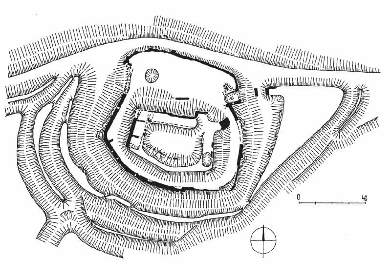
The castle occupied the summit of a hill 290 meters above sea level, dominating the valley, which opened to the southeast onto the lowland settlement of Svätý Jur and to the northwest cut deep into the Little Carpathians. Steep, high slopes protected the castle primarily from the valley side, that is along the entire northern section. However, the location was not the most advantageous from a defensive perspective, as the terrain on the other sides was not as steep. The easiest approach was from the southwest, where the castle hill connected to the rest of the mountain range, and it was also accessible from the settlement to the east.
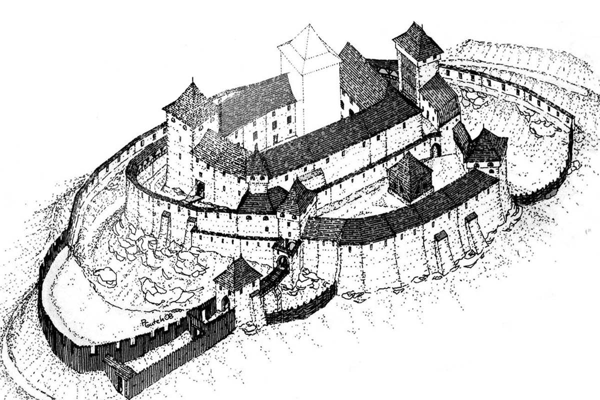
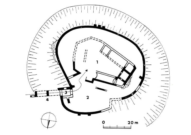
The castle had an elliptical plan, measuring 60 x 70 meters, with the upper ward occupying approximately 55 x 35 meters. The terrain ensured protection particularly from the north, which is why only in that direction was a ditch not dug and an earth rampart not built. In contrast, the most vulnerable southwestern part of the castle was preceded by no fewer than three ditches and two earth ramparts placed between them. Their considerable width allowed for the additional timber fortifications and a walkway on the crown. A stone wall was built on the inner rampart in the late Middle Ages, enclosing the castle in a semicircle from the west to the foregate in the east.
The access road to the castle led from the east, from the settlement, through the ditch to a triangular flattened area, likely a small outer bailey or foregate with wood and earth ramparts. In its northwest corner was a stone gatehouse, leading to a wooden bridge supported by a stone pillar, connecting with the northern lower ward. The defensive wall of the lower ward, likely built in the 15th century, also surrounded the entire upper ward, creating a zwinger on three sides. In the northern part, buildings for economic purposes were added to the inner face of the wall, while the eastern part was protected by a quadrangular gate tower. In the western part of the lower ward courtyard, a large water reservoir carved into the rock was located, to which ceramic pipes were supposedly fed from mountain streams. This may have been topped by a freestanding tower, known in records as the Water Tower. The lower ward also housed a bakery and stables.
In the upper ward, the southeast corner was occupied by a quadrangular tower, approximately 10 meters long on each side, serving both defensive and residential purposes. It is possible that another quadrangular tower was located in the southwest part of the courtyard. The main residential wing was likely the building in the northern section, which in the 15th century housed, among others, the castle owners’ living quarters and a chapel, as well as utility rooms on the ground floor. The later western range had three rooms on the ground floor. The southern wing was slightly angled in plan, due to the course of the defensive wall to which it was adapted. Entrance to the upper ward was likely from the east via a drawbridge spanning a ditch.
Current state
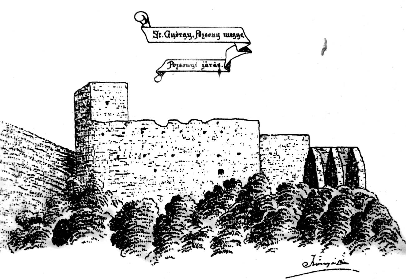
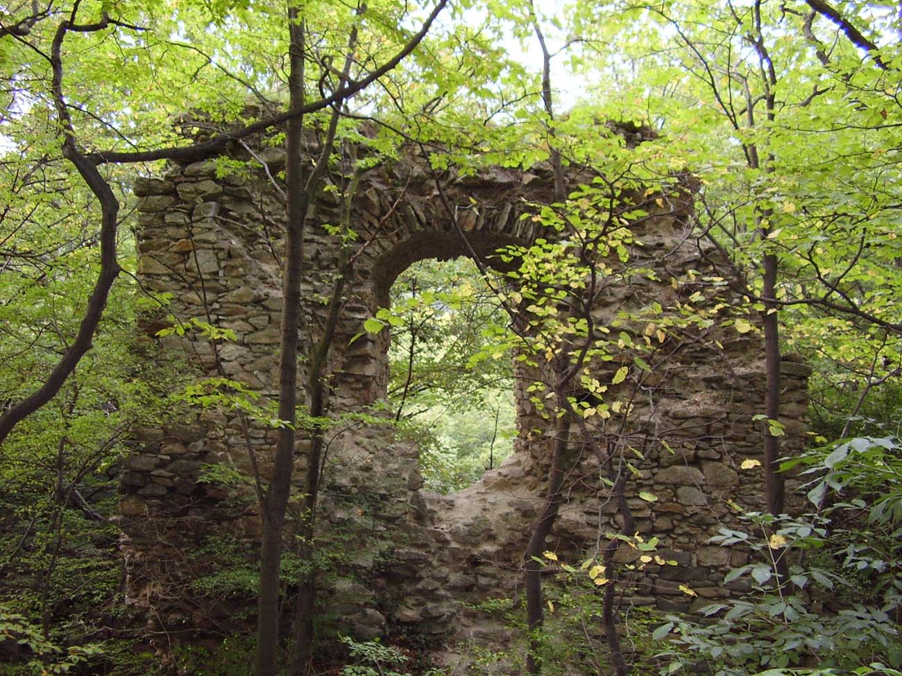
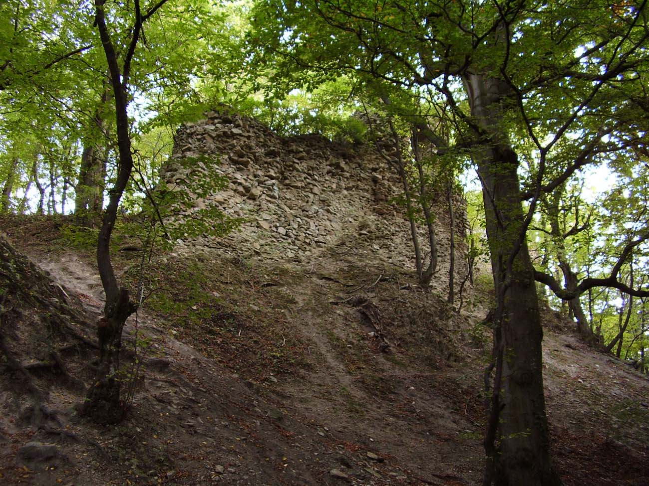
Today, only modest remnants of buildings and fortifications are visible on the forested hill. Of the upper ward relics of the main tower, fragments of ground-floor rooms on the western side of the courtyard, and the ruined vaulted cellars of the northern wing have survived. Of the lower ward, remnants of the gatehouse and large sections of the perimeter wall have survived, particularly on the southwest side, where it formed the outer wall of the upper ward. A large depression visible in the terrain is the remains of a water tank.
bibliography:
Bóna M., Plaček M., Encyklopedie slovenských hradů, Praha 2007.
Gahér D., Svätojurský hrad (Biely Kameň) z pohľadu archívnych prameňov, „Monument revue”, ročník 9, číslo 1, 2020.
Wasielewski A., Zamki i zamczyska Słowacji, Białystok 2008.