
History
The origin of the town was a hillfort and a settlement, located near the later erected castle, indirectly recorded for the first time already in 1007, when the Żary land was mentioned (“pagus Zara”), associated with a small Lusatian tribe. At the end of the 12th century, the borough, probably of a market function, was moved closer to the trade route called the Low Tract. In the new place there was a rapid development of the settlement, which in 1207 already had a church. The further development of Żary was ensured by the spatial reform of the settlement probably carried out by prince Henry the Bearded and the fact that Albrecht Dewin granted Magdeburg law in 1260.
The construction of fortifications began in the second half of the 13th century, when the town was managed by the Dewin family. Żary (German: Sorau) received the privilege of erecting fortifications together with the above-mentioned town foundation act in 1260. Initially wood and earth fortifications were erected, but from the end of the 13th century it were gradually replaced with a stone defensive wall. Most likely in the first half of the 15th century, due to the spread of firearms and artillery and the threat from the Hussite army, the fortifications were strengthened.
Written sources recorded one threat to the town, in the mid-15th century, during the invasion of the Hussite army. The defensive walls then played a rather deterrent role, because the attackers left with the ransom without taking up a fight. Then, at the end of the 15th century, a second, much lower belt of fortifications was made, running around the town from the south in the section between the gates, and the town gates itself were extended with foregates.
In the eighteenth century walls ceased to fulfill their original function, and, unrepaired, began to fall into neglect and disrepair. At the beginning of the 19th century, they turned out to be an obstacle to the further development of the Żary. Therefore, in 1820, after a fire in the town, their comprehensive demolition began. The damaged Upper Gate was then slighted, in 1827 the Lower Gate was demolished, although the adjacent tower was left. Demolition works and incorporation fragments of walls into modern buildings continued as late as the 1830s.
Architecture
The town was situated on the southern side of the Żarka River, in a hollow widening of its narrow valley, on a relatively flat area (the level difference between the eastern and western gates was about 4 meters). From the south-west, the town was bordered by a stream called Stara Żarka, connecting with the river, and in the south-east by a series of ponds connected by a nameless stream. On the northern side of the town, behind the river there were hills, but the area near Żarka was covered with swamps.
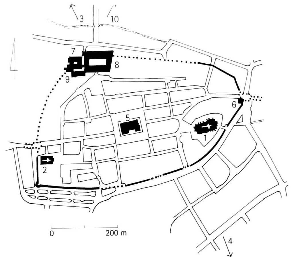
The circumference of the fortifications took the shape of an oval, elongated along the east-west axis, covering an area of about 11 ha. Its length was about 1400 meters. On the north side, a castle was included in the line of fortifications. Near the fortifications, there were two main sacral buildings of the town: the parish church on the south-eastern side and the Franciscan friary on the south-western side. The center of Żary was occupied by a market square with a town hall, connected by main streets with two town gates.
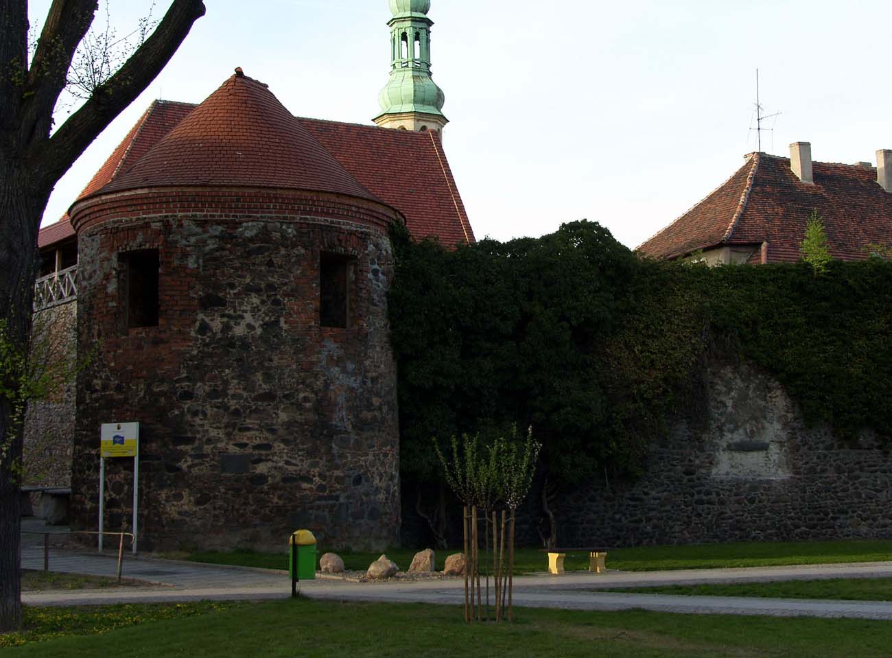
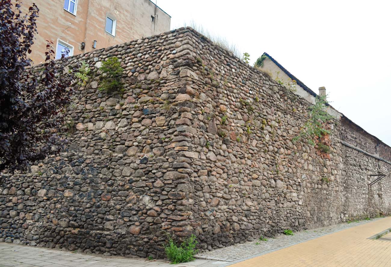
The defensive wall was built of erratic stones, supplemented with smaller, flat stones forming leveling layers, joined with lime and clay mortar. Its thickness reached 2 meters in the ground floor, and the height reached 8 meters. It was complemented by irregularly arranged rectangular half towers, opened from the town side and protruding in front of the curtain walls. At least in one, south-western corner of the town, there was a cylindrical tower. From the outside, the walls were protected with an irrigated moat, running in their immediate vicinity from the north and west. From the east, its role was taken by two ponds: a large one called “Lords Pond” and a small “Mill Pond”. The next ponds were located a little further from the fortifications on the north side of the town.
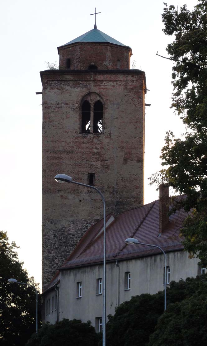
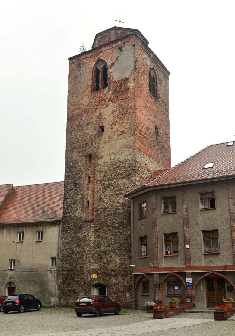
Access to the town was provided by two gates: Lower and Upper, located respectively in the eastern and western part of the perimeter. Both had the form of low, four-sided buildings with passages in the ground floor and guard rooms on the first floor. They were protected by the neighboring massive and high towers, flanking the entrance to the town on one side. An auxiliary role in communication with the areas on the north and south side of the Żary was played by narrow posterns, which could be walled up in case of danger.
At the end of the fifteenth century, a second line of fortifications was created. An external, lower defensive wall was erected on the southern section, considered the most endangered due to the lack of significant water obstacles. The outer wall was created between the Upper and Lower Gates. It was also then that the foregates were built, extended a few meters in front of the older gates and the line of the main defensive walls, preceded by bridges over the moat.
Current state
Short sections of the town wall have survive in the northern and eastern parts of the former perimeter. The best-preserved fragment of the fortifications in Żary is located in the south-western part of their course, i.e. on Cicha and Podwale streets, where a circular tower also has been preserved. In the eastern part of the town, the tower of the Lower Gate has been preserved. At a distance of several dozen meters, to the south of it, there is the second of the defensive towers, which from the 16th century also served as the belfry of the parish church. The preserved sections of the wall are lowered compared to the original state, they are from 3 to 5-7 meters high and do not have the original crown.


show the tower of the Lower Gate on the map
show belfry / tower on the map
bibliography:
Biała karta ewidencyjna zabytków architektury i budownictwa, mury miejskie, W.Janowska, nr 7389, Żary 1999.
Kowalski S., Zabytki architektury województwa lubuskiego, Zielona Góra 2010.
Pilch J., Kowalski S., Leksykon zabytków Pomorza Zachodniego i ziemi lubuskiej, Warszawa 2012.
Studia nad początkami i rozplanowaniem miast nad środkową Odrą i dolną Wartą (województwo zielonogórskie), red. Z.Kaczmarczyk, A.Wędzki, tom 2, Zielona Góra 1970.