
History
Wschowa (Veschow in 1248, Frowenstadt in 1290, later Fraustad), recorded in 1136 as the property of the archbishop of Gniezno, and founded in the years 1248-1275 as a peripheral town of Silesian princes, was probably initially surrounded by wood and earth fortifications. Even in 1345, the construction of palisades was planned, which would indicate that the town was surrounded by brick walls only around the beginning of the 15th century, but it is possible that the timber fortifications coexisted for some time with the walls built from the 14th century. The process of rebuilding the fortifications was long, costly and gradual. The aforementioned works from 1345 were probably aimed at removing the damages sustained by the fortifications during the capture of the town two years earlier by the Polish army of King Casimir the Great. It is known that during the fights, the Poles breached the fortifications through which they entered and captured Wschowa. The town itself was not destroyed then, because the king, at the expense of the Duchy of Głogów, permanently attached it to the Kingdom of Poland.
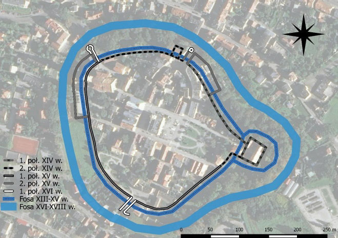
The construction of brick fortifications began no later than in the second half of the fourteenth century, because the privilege from 1409 mentioned old walls and moats. The first parts of the walls could have been erected at the turn of the 13th and 14th centuries. The earliest part was in the north-eastern fragment of the perimeter, erected from the most endangered side, because not protected by natural terrain obstacles. It is difficult to determine the time and sequence of construction of further sections. It is very likely that the circuit was closed after 1409. This would be suggested by the content of the privilege from the same year, in which King Władysław Jagiełło ordered the town to be fortified with a wall and the old walls to be repaired. With the completion of the construction of the first line of the walls, the town and the castle were connected with one defense system.
In 1383, the town defended against the invasion of the prince of Głogów, Henry known as Sparrow, who tried unsuccessfully to use the political chaos after the death of Louis of Hungary. Once again, military operations took place near Wschowa in 1474, when the town was raided by Jan II of Żagań, known as the Mad, with the help of artillery, at the head of the troops recruited by the help of king Matthias Corvinus. This siege also turned out to be ineffective, and the Polish-Hungarian war, carried out with varying degrees of luck, did not end until 1479.
Renovation and modernization of the town walls began almost immediately after the completion of their construction. The works were undertaken on the initiative and with the support of the kings, and one of the reasons for concern for the town’s defense was its border location. The periods of intensification of works were determined by privileges: from 1426 and 1444. In the first one Władysław Jagiełło exempted the inhabitants from market taxes in exchange for strengthening the walls, ramparts and moats, and then this privilege was repeated by king Władysław III. The most important undertaking during this period was the construction of the outer wall, first recorded in 1444. During the modernization works, the water defense system around the town was expanded and the damaged sections of the walls were repaired; especially after the fights in 1474 and the fire in 1529, which destroyed the timber elements of the fortifications. Exemptions of burghers from fees in order to spend them on repairs of fortifications were recorded in 1513, 1525, 1532, 1534 and 1590. In 1587, the defensive wall from the south was significantly raised, and in the course of further works, the gates were rebuilt.
In the 17th century, the defensive values of the town’s fortifications began to be limited due to the addition to them of secular and sacral buildings, including the Evangelical church or the Jesuit college. In the 18th century, the archaic and obsolete defensive walls fell into decline, and soon afterwards, in 1801 and 1803, both town gates were pulled down. The process of gradual lowering and removing the curtains as well as burying the moat and leveling the earth ramparts was also continued.
Architecture
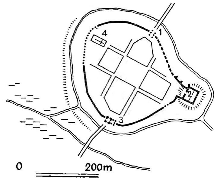
The city was founded on the wet ground of a proglacial valley, in an elongated, basin-like area. The walls of Wschowa lay down a form similar to a wheel, somewhat flattened from the north east and south-west, probably for field reasons. The town walls were locked in the castle, so that they moved out into the eastern part of the perimeter, forming a short neck. The area of the town was 5 hectares and the length of the fortification lines was about 950 meters. In the western part of the town, in the immediate vicinity of the fortifications, a parish church was located, whose tower could be considered as a defensive post.
Defensive walls of Wschowa were mixed stone-brick. Its lower part, up to a height of 2.8 meters, was made of erratic stones joined with lime mortar, above were the bricks laid in the monk bond. From the beginning of its existence, the walls were reinforced with buttresses. The wall thickness was 1.6 to 1.9 meters at the base; the height and type of the parapet are unknown. The latter was probably supplemented by the sort of hoarding; the account from 1529 recorded low towers, perhaps bartizans, which burned down during a fire of the town. The top of the wall had to be changed during its raising at the end of the 16th century. The inner defensive wall did not have any towers.
The outer wall, added shortly before 1444, did not form a full ring, but was added only from the most endanger north-east and west sides, near the parish church. These sections were separate, independent and closed defense points. The outer wall was about 1.5 – 1.6 meters thick and had the top in the form of a battlement, placed at a height of 6-7 meters. In addition to battlements, it also had arrowslits. It could also be reinforced with bastions or low towers.
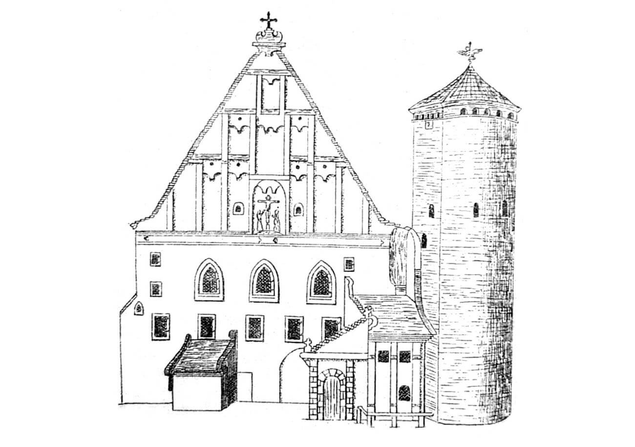
Wschowa had two gates: Polish from the north and Glogowska from the south. Both lay on the main traffic route, which ran through the town, with two arms embracing the market. Głogowska Gate consisted of three parts. The first was a two-storey gatehouse. The ground was covered by a passage, and on the first floor there was a room accessible by an external timber staircase. On the ground floor there was also a guard’s room. The gate was protected and closed with a drawbridge. Next to the gatehouse, a defensive tower stood in the line of the defensive wall. Its form is not sure. Probably on a square base stood a circular part. In the lower storey of the tower was custody, available only from upper floor by a rope or ladder. Above there were two more storeys. The third part of the gateway was the foregate with the front gate standing in the line of the earth ramparts. To this gate led the bridge through the moat.
The layout of the original Polish gate is not known. Probably with it was related a four-sided building with dimensions of 14.5 x 17.5 meters added to the outer side of the defensive wall. In its lower part there were gaps between which the moat was flowing. The height probably did not exceed the height of the wall and was about 9 meters. Bartizan was hung in its corner, and on the inside the stairs lead to the crown of the wall and this building. It burned down in 1529, and probably than the passage of the Polish Gate was shifted further to the east. Its second element was a two-storey gatehouse.
Beside the two gates, Wschowa had wicket gates. The oldest of them probably built in the sixteenth century, the wicket Poland Gate lay in the western part of the circuit behind the parish church and was a fully defensive structure. The brick building of the gate was joined by a neck with a small barbican standing in the line of the earth ramparts. A wooden bridge crossed the moat. Other wicket gates were of late origin and were created during the fall of fortifications. They had the form of ordinary holes pierced in the wall.
The outer part of the fortification belt was made up of a moat and an eart rampart. These devices were probably related with early wood-and-earth fortifications and with defensive walls since the beginning of their existence. The moats were mentioned for the first time in 1409 as old, and the earth ramparts in 1426. The moat was located 2 to 5 meters from the defensive wall line, it was about 11-13 meters wide and 1.3-1.5 meters deep. Its slope was reinforced with wooden piles. It was irrigated, which is confirmed by the regulation of the inflow of water to it, made in 1532. It was during this period that the general expansion of the outer defense zone around the town began. As a result of these works, the following layout arose: behind the wall, the rampart road continued, then the earth shaft ran, followed by a wide moat. The moat was then moved about 20 meters from the main defensive wall and expanded to about 25-50 meters wide. Originally from the east, south and south-west, the town was surrounded by a strip of vast wetlands, while from the north there was a wooded, slightly mountainous area.
Current state
In Wschowa large parts of the defensive walls were preserved, as they were not planned to be dismantled. In no case did the upper part of the fortifications reach our times. The height of the relics is generally 2-4 meters above the present level of the terrain from the outside.
In the southern part of the perimeter the remains of the walls are stretched several hundred meters from the castle to the parish church. In the western part of the town, behind the parish church, the inner defense wall is not visible. It remains are probably under the plaster of the former jesuit college. In this section there is a fragment of the outer wall. Between parish church and the former gate of Poland, that is in the north-western part of the perimeter, further parts of the inner wall are preserved again over a distance of over 100 m. The preserved tower of the front gate, standing in the line of the outer wall, has been transformed into a belfry of the Evangelical church. In the north-east section, a fragment of a defensive wall, located near the castle, is preserved.

bibliography:
Drgas J., Fortyfikacje Wschowy w średniowieczu i czasach nowożytnych, Wschowa 2018.
Tomala J., Murowana architektura romańska i gotycka w Wielkopolsce, tom 2, architektura obronna, Kalisz 2011.
Studia nad początkami i rozplanowaniem miast nad środkową Odrą i dolną Wartą (województwo zielonogórskie), red. Z.Kaczmarczyk, A.Wędzki, tom 2, Zielona Góra 1970.
Widawski J., Miejskie mury obronne w państwie polskim do początku XV wieku, Warszawa 1973.