
History
The area of Wolin was first settled in the Stone Age, around 4200-1700 BC. Since then, man has been on the island practically continuously, creating residences in the Bronze Age, Iron Age, and the period of Roman influences. When in the 4th century AD great migrations began in Europe, Slavs came to the island of Wolin, who around early 6th century probably established at the Wolin crossing one of the few permanent habitats during the Migration Period. The location on the Dziwna River, convenient access to the sea and the location on trade routes provided excellent conditions for the development of settlements. Thanks to this, a small fishing village from the end of the 8th century or the turn of the 8th and 9th centuries quickly increased its population and buildings. At the turn of the 9th and 10th centuries, a port was built, the river crossing was expanded, shipping and manufacturing developed, and trade contacts with other centers were established. Wolin was then surrounded by wooden and earth fortifications, becoming the main center of the Wolinian tribe, and later also the center of the Slavic cult of Svetovit – Triglav.
The largest development of the Wolin stronghold began around the middle of the 10th century. It then became an important center of craft production, an exchange center and a communication junction. It was managed by the Slav tribal elite, whose material culture was characterized by clear Norman influences. German chronicles and Scandinavian sagas mentioned the lush history of the stronghold. It appeared in them under the name Jom, Jumne and Jómsborg, it was to be the seat of a Vikings brotherhood called Jómswikings. According to Jómswikingasaga, Palnatoki jarl built a fortified town touching the open sea in the 10th century. The huge port, which could accommodate 300 ships, was to be closed by an iron gate, over which a stone tower was guarded. The Viking group was to organize bold expeditions from here. Adam of Bremen also wrote about Wolin, specifically about Jumme, who according to him was the largest stronghold in Europe, inhabited mainly by Slavs, but also by Greeks and Saxons. The way to the port of Jumme was to be shown to sailors by a lighthouse called Greek Fire. According to the chronicler Saxo Grammar, the stronghold on the Dziwna river was “the largest of those in Europe, which are inhabited by Slavs and other nations”, and according to Ibrahim ibn Jakub, as many as 12 gates were to lead to the stronghold.
In 967, Mieszko I, the ruler of the emerging Polans, won the battle over Wolinians, as a result of which the town was briefly subordinated to the Piasts dynasty. In 986, after the rebellion, the Danish King Harald Bluetooth took refuge in Wolin, so it is possible that the stronghold was then in the sphere of Danish influence. The inhabitants, although pagans, were to receive the ruler hospitably, but after a few days he died of his wounds anyway. According to some other written sources (Fagrskinna, Knytlinga Saga, Gesta Regum Danorum) Harald Bluetooth was supposed to be the founder of Jómsborg, a strong fortress with a Danish garrison. In this alternative version, he did not die after appearing in Wolin, but used the inhabitants of the stronghold to raid enemy lands in Denmark. He was also supposed to leave the governor in the stronghold before returning to his homeland.
Rebuilt at the turn of the 11th and 12th centuries, Wolin pursued an independent policy for about twenty years, when it lost its sovereignty to the ruler of Pomerania, Warcisław I, who in turn was militarily subordinated to Polish Bolesław Wrymouth. Soon after, the inhabitants of the stronghold underwent more intensive Christianization, led by Otto of Bamberg, who stayed in Wolin twice during his journey in the years 1124-1125. In the interval between these visits, the inhabitants of Wolin were to return to their original practices, organizing some theatrical games (“ludi scenici”), which was supposed to cause a fire in the town, considered by superstitious people to be a punishing act of supernatural forces. Perhaps thanks to this, in the absence of the Bamberg bishop, who then went to Szczecin, the decision to convert the town religion was made. Already in 1140, Pope Innocent II approved Wolin as the seat of the first bishopric in Pomerania, with the cathedral of St. Adalbert as the main church of the diocese. The first bishop was Adalbert, the chaplain of the Polish Prince Bolesław Wrymouth.
In the second half of the twelfth century, the role of long-distance trade, which was the basis of the wealth of residents, fell, and the town was destroyed several times by Danish pirates. These raids were the main reason for the fall of Wolin, but the problem was also the proximity of Kamień Pomorski, which tried to subordinate Wolin and the competition of nearby Szczecin, which had better development conditions. Wolin was no longer able to return to its former glory. Apart from the destruction of the stronghold, the sanding and silting of Dziwna river also contributed to its fall, which sealed the fall of trade. The transfer of the bishopric to Kamień in 1176 was the complement to the fall of the stronghold, in the place of which after about a hundred years a medieval town was founded. It was neither a large nor significant center, although in the first half of the fourteenth century it was surrounded by stone and brick defensive walls.
Architecture
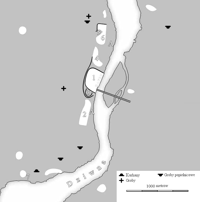
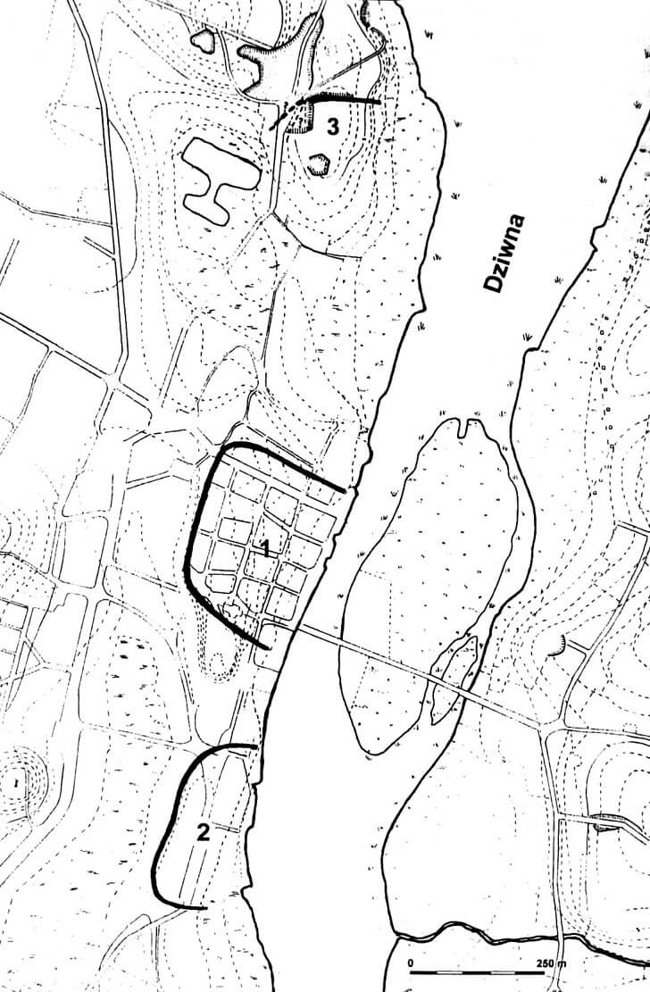
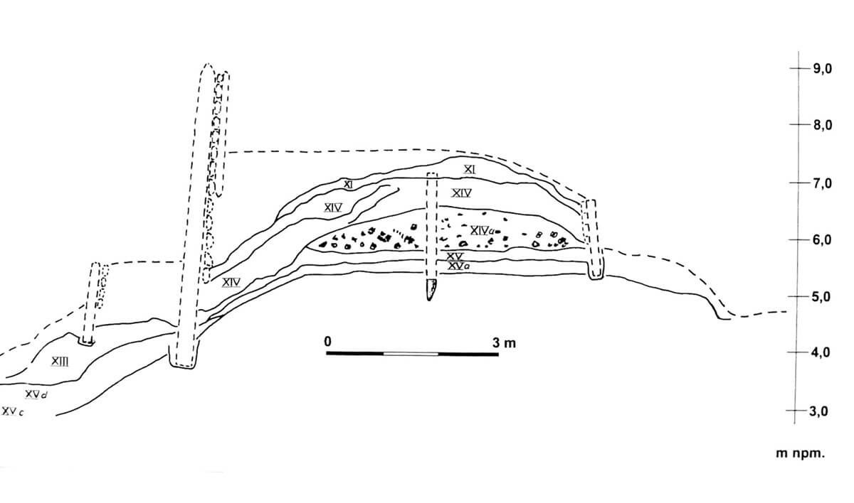
The early medieval settlement of Wolin was located in the southern part of the island, on the west bank of the Dziwna River, and was divided into a number of locations, the most important of which were: the stronghold (Old Town), the southern borough, the so-called Kącina, the Ogrody settlement, the Silver Hill, the cemetery on the Młynówka hill, the barrow cemetery on the Hangman’s Hill and the southern settlement. Of these, fortifications had three centers: the main stronghold (Old Town), a settlement on the Silver Hill and the southern borough. Of these, the center of Wolin had the most powerful, repeatedly improved, repaired and thoroughly rebuilt fortifications.
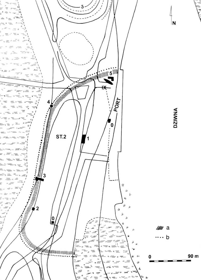
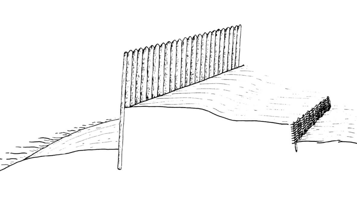
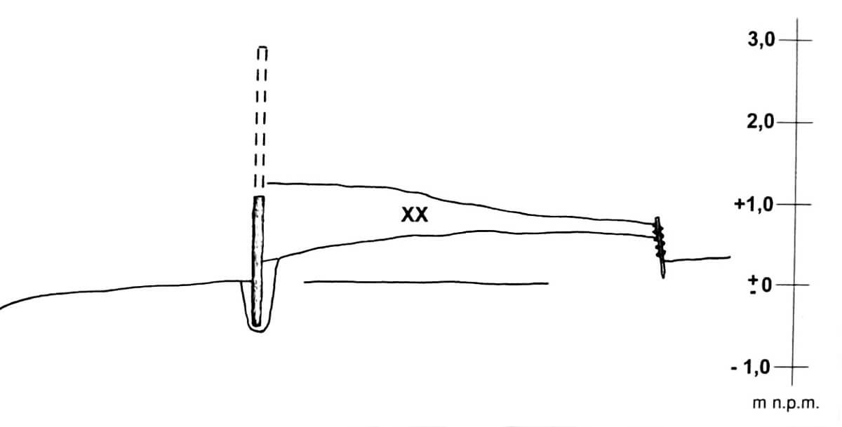
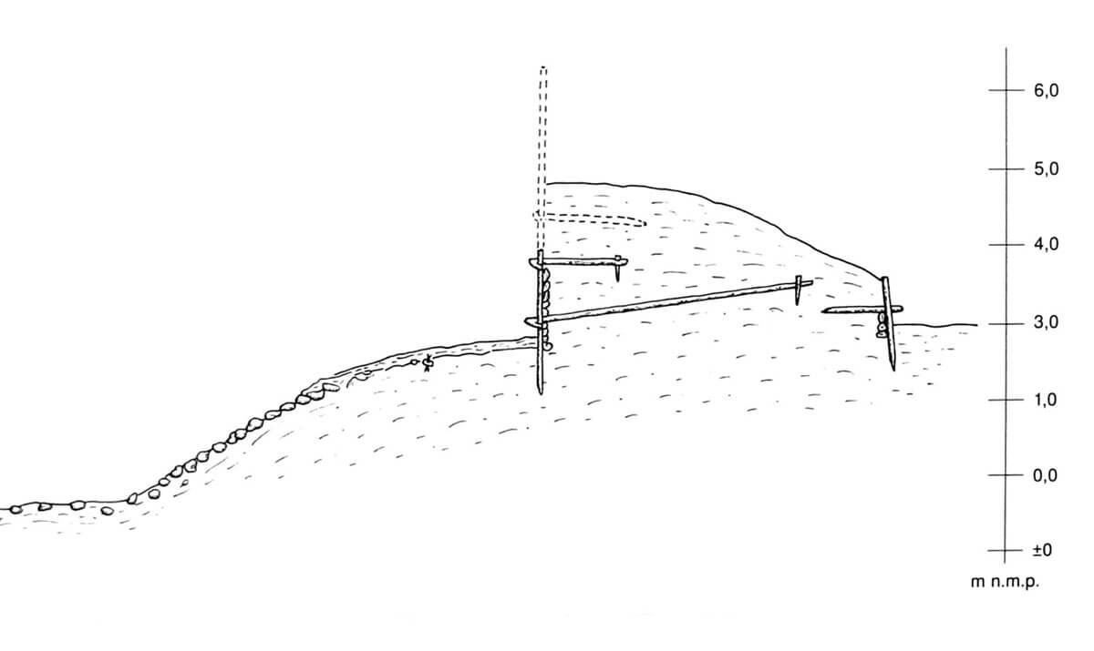
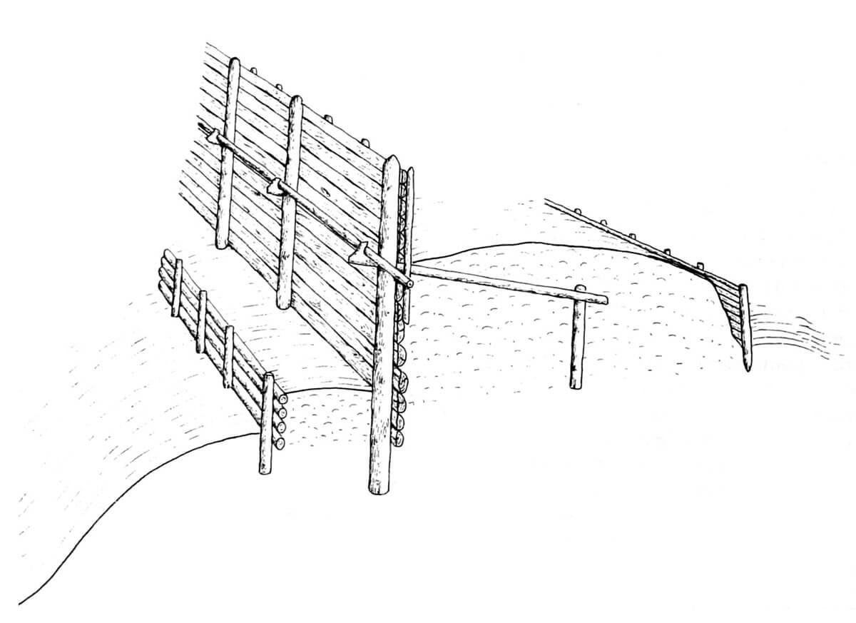
The oldest fortifications of the stronghold, erected probably in the second half of the 9th century, were located right on the border of a wetland swampy area stretching from the west. Their length was about 650-750 meters. In the plan it received a shape similar to a semi-circle, or the letter C meeting the extremities with the river in the east, near the crossing through it. The fortifications probably were not on the Dziwna side itself, where the port operated. This posed a great threat, so maybe there were some obstacles hindering free access to the stronghold. The fortification line functioned only with minor corrections until the late Middle Ages. Initially, it consisted of a palisade erected from oak logs, embedded closely one next to the other in a ditch 0.6 meters wide and 0.8 meters deep. They had almost rectangular or semicircular cross-sections, which indicates that at least three were obtained from one trunk. To the front wall of the palisade, a ground shaft with a width of up to 4.5 meters was attached from the inside of the settlement with an internal part reinforced with a braided wall running parallel to the palisade. The braid consisted of short oak dowels, driven slightly obliquely into the ground and braided horizontally. The shaft itself could not be higher than 1-1.3 meters in relation to the ground level from the outside (a higher one could cause tilting or collapse), while the palisade to effectively protect defenders had to be at least 1.5 meters high. In addition to its defensive function and raising the height, the earth rampart also stabilized the palisade and prevented Dziwna waters from entering the town during periodic raising of its level.
Probably at the beginning of the palisade’s functioning, and at the latest in the first years of the tenth century, a general reconstruction of the fortifications began. Their core created a much wider earth rampart, strengthened from the outside with a massive pole palisade, and from the inside of the stronghold with a retaining wall. The width of the rampart at the base was 5.6 – 5.7 meters, while the height originally had to be at least 2 meters. The new palisade was erected in a very ingenious way at a distance of 0.7 meters from the inside of the stronghold and the older palisade. It was set on a kind of foundation in the form of a horizontal oak square timber with cut out holes, strengthened from the outside with two dowels. It was 3.5 meters long, 0.6 meters wide, and through its center ran a row of square or rectangular openings spaced approximately every 19-26 cm. Lower, sharpened portions of poles forming the palisade were embedded in these holes. The poles were split oak logs, debarked and carefully machined. The palisade was placed slightly obliquely inside the shaft, always with a convex part outside. The border of the rampart from the town side was formed by a vertical wall formed of several or a dozen poles, arranged horizontally on top of each other and supported by vertical dowels, anchored to the center of the rampart with specially prepared beams.
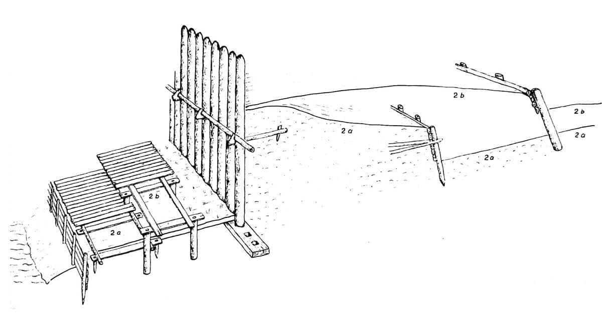
In the fourth quarter of the tenth century, the third phase of rebuilding the fortifications began, although they did not undergo any destructive catastrophe, and were only naturally impaired by the time. Than, the old palisade was removed and the earth rampart was raised, which henceforth consisted of two parts: an earth core encased in wood and strong fortifications of the fore-rampart, treated as the first line of defense. Its width was 8.7 meters, of which 5.3 meters were on the core and 3.4 on the fore-rampart. The first one consisted of two vertical, not connected walls, forming a space filled with earth. The outer face was formed by a poles formed of round logs (oak, beech, alder and pine) arranged horizontally on top of each other, supported from the outside with vertical posts equipped with hooked stays, anchored inside the earth rampart. The face of the shaft from the side of the stronghold was built in a similar way, while in front of the palisade there was an earth threshold of 3.4 meters wide and at least 0.7 meters high, reinforced from the outside with wooden constructions. This fore-rampart consisted of a retaining wall erected parallel to the face of the shaft, formed of solid oak beams. They were, like the main line of fortifications, arranged horizontally on top of each other and tied with perpendicular, hooked ends of guy-wires, additionally reinforced with vertical poles, which were also equipped with guy-wire. All these elements were extremely precisely matched to each other.
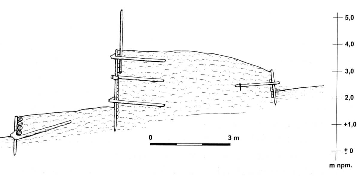
At the end of the first half of the 11th century, and at the latest in the third quarter of the 11th century, perhaps after the invasion of 1043, the fourth phase of reconstruction of the stronghold fortifications began. New constructions were mounted directly on older remains, additionally the outer slope was reinforced with stones. From then on, the core of the fortifications was a wood-earth shaft core composed of wooden faces (external and internal) and central filling. Outside, there was a terraced earth bench 2.5-3 meters wide, with reinforcing wooden structures and a slope descending towards wetlands, as mentioned, faced with stones. The width of the shaft base was 10.5 meters, with the core 4.4 meters wide. Its outer face coincided with the face of the older rampart, but from the side of the stronghold fortifications were shifted. As in the older phase, the external face was made of a wall of horizontal poles and beams stacked on top of each other, equipped with hooked stays anchored in the middle of the rampart. The assumed height of the defensive wall was similar to the previous one and was at least 3.5 meters, and the retaining wall from the town side about 1 meter.
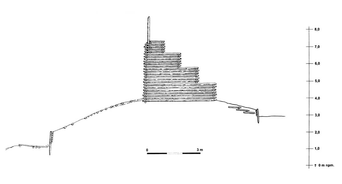

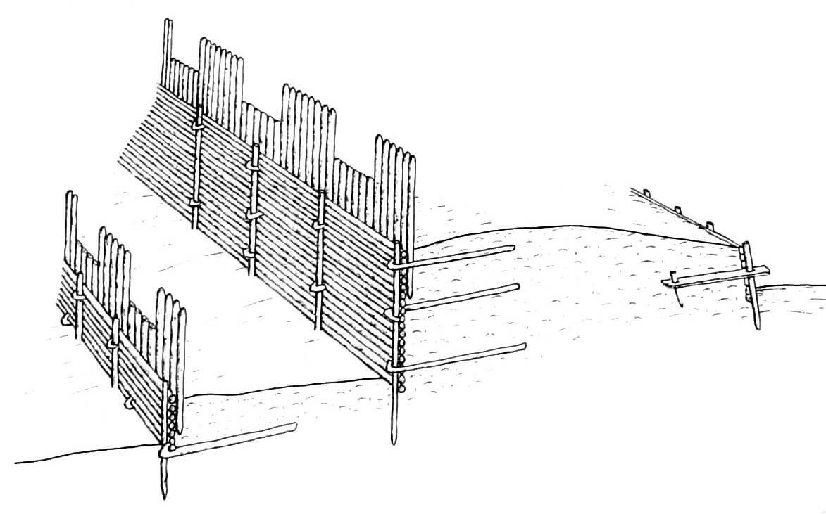
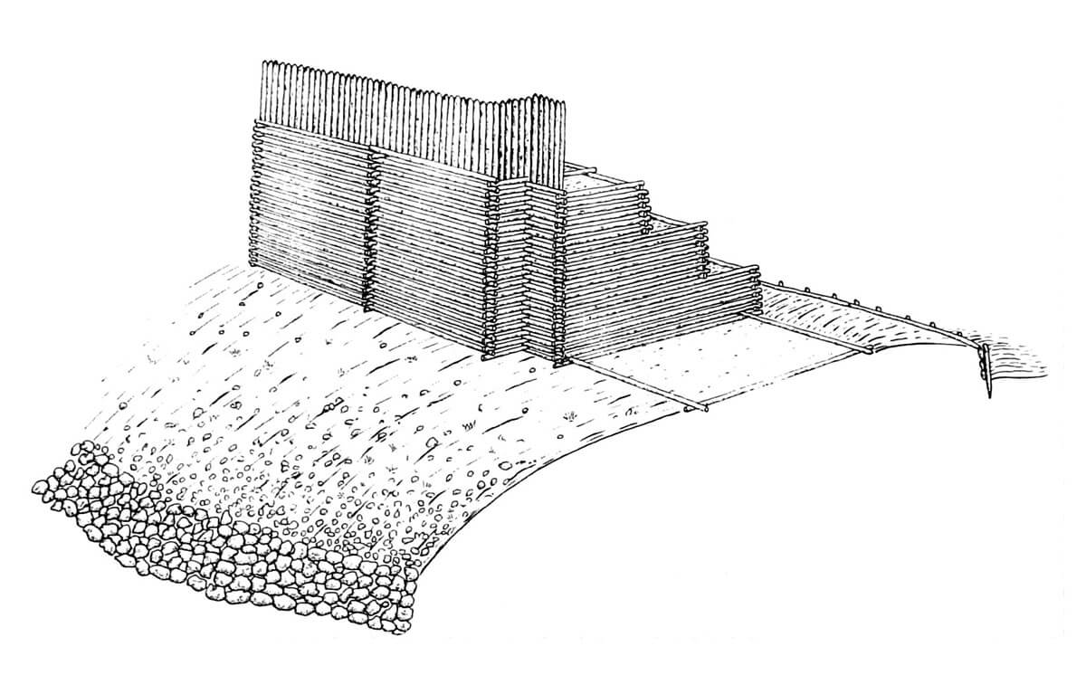
In the fifth phase of the stronghold fortifications development (end of the 11th century – first half of the 12th century), due to the use of poor material at an earlier stage, there was a general reconstruction and complete change of structure, while maintaining the former fortification line. The width of the rampart base was kept (12.3-13.3 meters), but it was raised, obtaining a basic mass of earth from old fortifications to which all kinds of waste and garbage from the inside of the stronghold were added. On the crown of the rampart, box (chest) fortifications were erected, perhaps created under the influence of Szczecin, where they were used several years earlier (although the box technique had a much older record). These structures were relatively simple to make, did not require the highest quality wood, and allowed the construction of high and stable walls. The chests were built in a log construction about 4 meters wide and more than 3 meters long, which probably gave a plan similar to squares. There are many indications that only the bottom level of chests was filled with earth, and only partially, while the higher one was empty, perhaps used in some way. From the outside, the earth rampart was protected against slipping by a wooden retaining wall 0.8-1 meter high, erected from non-barked beams arranged horizontally and reinforced with vertical dowels. A similar, but slightly lower (0.4-0.7 meter) retaining wall was also created from the side of the town.
In the sixth phase, the earth rampart was slightly raised, by about 0.1-0.5 meters, and the width of its base was slightly narrowed. The previously used type of chest constructions and the way of strengthening of the slope from the town side were used in the crown of the rampart. On the other hand, the innovation was the stone strengthening of the outer base of the rampart and solid facing of slopes with stones. The height of the rampart in relation to the terrain on the field side was then 3.6-3.9 meters, and inside the settlement about 1.2-1.7 meters. These fortifications were certainly destroyed during violent fighting and fire, most likely during the Danish invasion of 1173. Soon after, the reconstruction began (phase seven), collecting unburnt logs and leaving only those deep in the ground. The new shaft was slightly lower (3.1-3.5 meters) and again topped with fortifications of the chest structure. The latter in the sixth phase were covered with clay, which was to protect against fire arrows of opponents.
After the destruction of the fortifications of the seventh phase, which probably took place in 1184, there was a long period when Wolin was without protection. This probably lasted until the foundation of the town in 1279, when a new earth rampart was erected, built exactly in the place of old, early medieval fortifications. The fortifications probably formed a double wall, filled with earth and perhaps clay stuck from the outside. Its face must have been created by vertical wooden poles. Then, in the last phase of the development of Wolin’s fortifications, around the first half of the fourteenth century, stone and brick walls were erected on the earth ramparts, although not at the top, but slightly below. Their foundations with a width of up to 2.6 meters consisted of large erratic boulders laid without the use of mortar, while the wall core, constructed in the opus emplectum technique, was 2.2-2.3 meters thick and strengthened from the outside with buttresses. Probably some parts of stone fortifications were supplemented with wooden fortifications in the form of a palisade, and after some time a street was built next to the wall, not paved for a long time.

The southern borough, separated from the main stronghold by a belt of swamps, was surrounded by a pole palisade as early as the first decade of the 10th century. It took on a similar, though slightly more elongated, semi-circular form, limited from the east by the Dziwna and from the west by a belt of wetlands. A little later, during the second half of that century, an earth rampart was created, moved further into the settlement. Probably, when the main stronghold of Wolin was fortified with a chest ramparts, a similar structure was also used in the southern borough. Its fortifications were about 570 – 600 meters long, without any protection from the east coast. The southern borough was probably a fishing harbor, certainly poorer than the main stronghold and northern suburbs.
At the same time, at the beginning of the tenth century, also the northern suburb of Silver Hill was fortified with a rampart about 200-220 meters long. It was a craft suburb, maybe a commercial one, with its own port on the river. Its settlement took an elongated ridge, embedded between the swamps in the west and Dziwna in the east. To the south there was a narrow settlement zone reaching up to the fortifications of the main town. Due to the favorable terrain, it was decided to defend there only the relatively easily accessible northern side, with its western end turning slightly to the south. The base of the fortifications of the Silver Hill was in the first half of the 10th century a solid earth rampart faced on both sides with walls of horizontal beams leaning on vertical poles, dug into the ground at a certain distance from each other. It is not known whether any lighter type fortifications were connected to the timber and earth rampart, e.g. a palisade running along the swamps from the west and along the Dziwna.
The earliest buildings of the settlement from the end of the 8th century occupied the area of the southern part of the hill, near the crossing of the river. They were semi-dugouts, in-between-pillars houses and log houses. Significant amounts of slag testify that ironwork and the production of everyday objects were involved in the outskirts of the settlement. After expanding the fortifications, in the second half of the 9th century in the most representative part of the stronghold located on the top of the hill, a quarter of several large and unique in terms of structure buildings, erected in the post-and-plank technique was created. Such huts were not discovered anywhere else in Wolin, so you can think that they were of significant importance to the stronghold and were inhabited by the then elite. At the turn of the ninth and tenth centuries, buildings of a previously unknown palisade structure were erected, built in the Ogrody district, in the southern suburb, as well as in the Old Town. However, the dominant type of houses were buildings with Wolin-specific in-between-pillars construction. In the tenth century, numerous smaller settlements of fisheries, agricultural and breeding character, and partly craft, were established in the area, creating a direct economic base for the Wolin town.
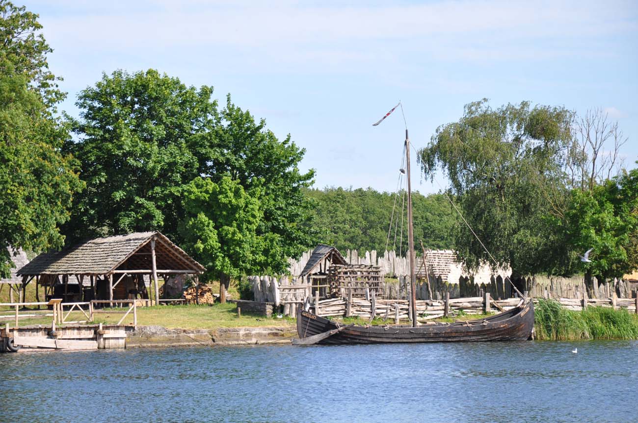
At the turn of the 9th and 10th centuries, when the stronghold acquired early town features, apart from the fortifications, the reconstruction of the waterfront began. At that time, wooden quays were built, erected of 10-meter-long crates, filled with fascine, earth and stones. The wall of the waterfront was strengthened with planks, i.e. boards obtained from the splitting of oak trunks, which were framed in the bottom of the strait. To reinforce the structure, these frames were anchored from the land side with guy-wires. The planks were set in the bottom at a depth of only 10-15 cm, which meant that when the water level increased, the structure did not fall over. The waterfront ended with a street extended beyond the waterfront and forming a bridge to which ships of various sizes could moor. If we assume that the waterfront stretched the entire length of the stronghold, i.e. between the ramparts in the north and south, it would have to reach a length of 250-300 meters and consist of about 25-30 oak crates. An important element of Wolin’s buildings was also the bridge connecting the center of the stronghold with the continent, crossing the islands on the Dziwna. It was first confirmed by written sources in the first half of the 12th century (the life of Saint Otto). The port at the main town was not the only one. In addition to it, there were also marinas at the Silver Hill, the southern suburb, the Ogrody settlement and the Hangman’s Hill.
At the end of the 10th and at the beginning of the 11th century, further expansion of the town to the north took place. In the Ogrody district, apart from the port quay, production buildings were created in the form of leather and woodworking workshops, bread ovens and a tannery. Craft workshops and a market operated at that time on the Silver Hill. In the swampy areas thick layers of fascine were used, and even wooden grates. The houses were still erected mainly in the in-between-pillars technique.
The Wolin stronghold was to be a center of pagan religion, so there had to be temples in it. One of them was a building with a post-and-plank construction, erected in a technique rarely used in Wolin, in the area of which a famous statuette of a four-faced deity was found. A complex in the town center was also indicated as a complex of sacred buildings, erected among cramped buildings, in a separated and fenced area, which formed a closed courtyard, where a roughly middle-sized structure of 5×5 meter was standing in the middle. The area of such a temple would be very small, no meetings and councils of elders could take place there, which had to be carried out in the courtyard, also at dusk, which could be proved by numerous slaked torches.

Current state
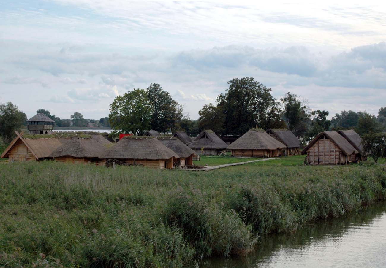
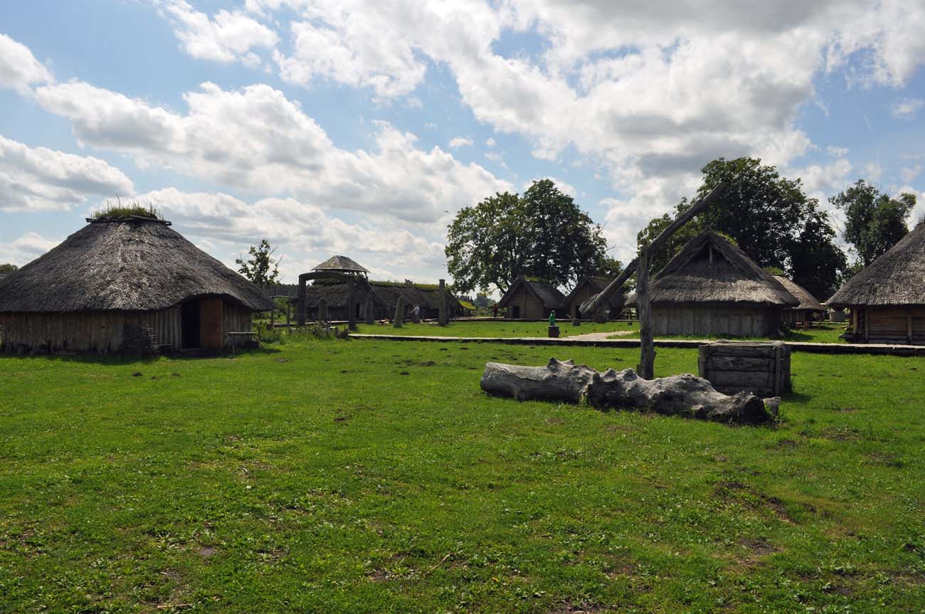
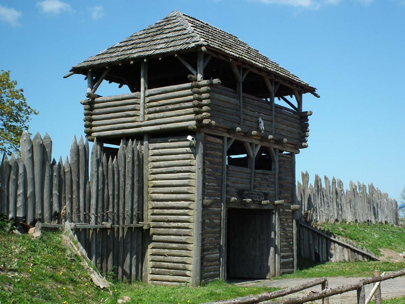
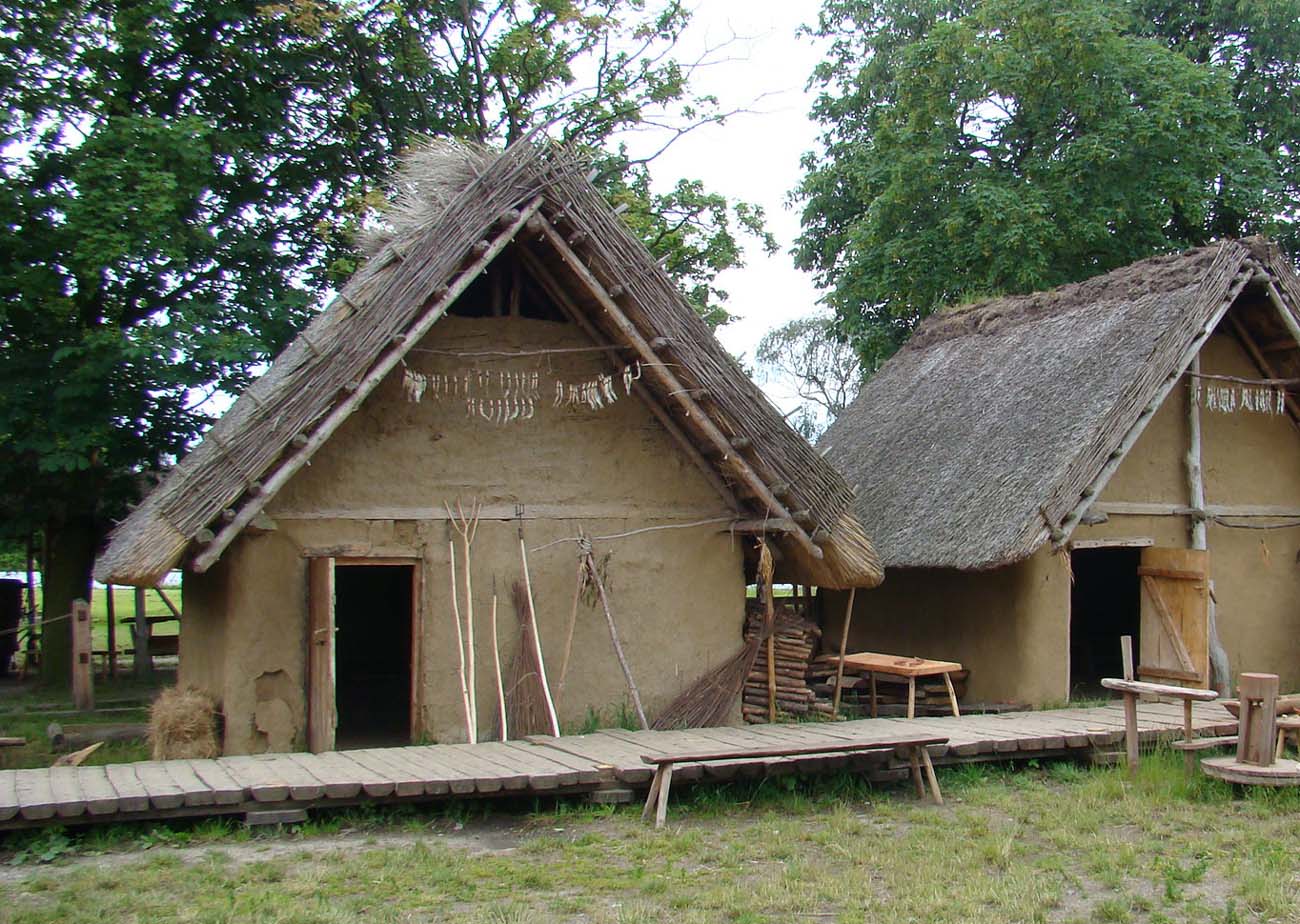
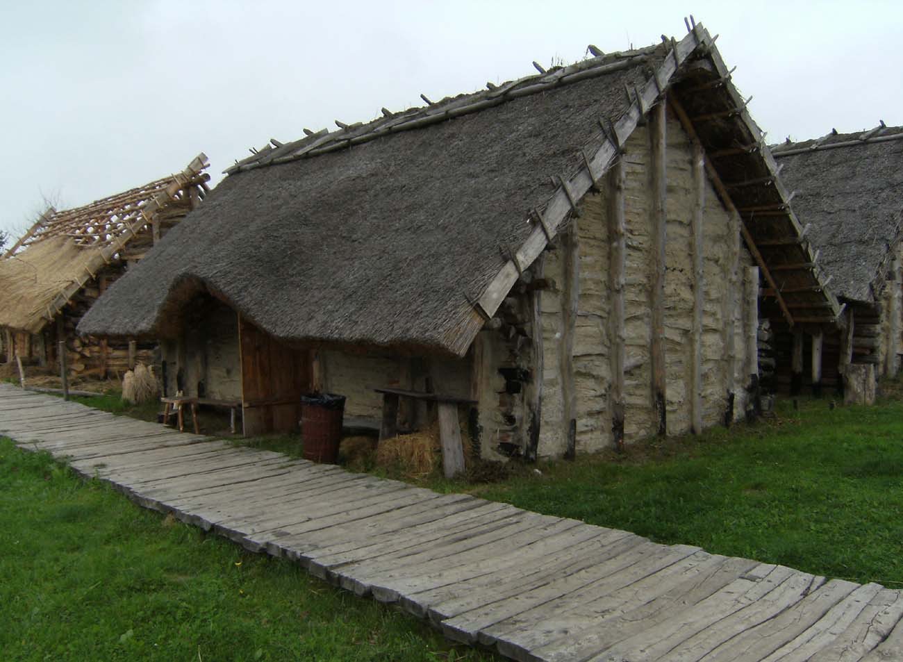
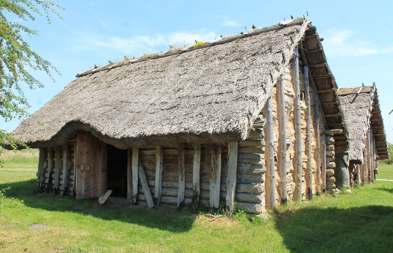
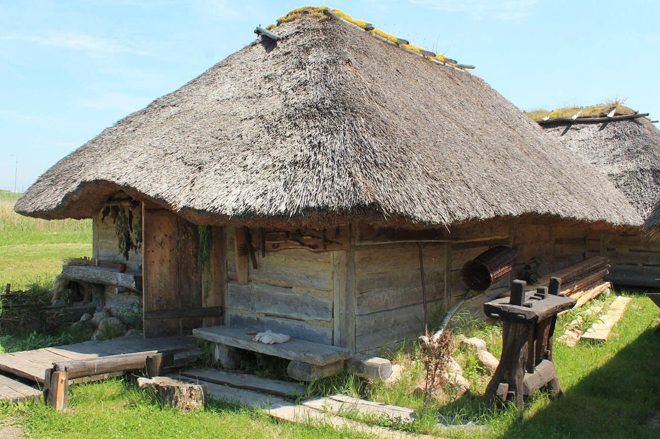
Currently, in Wolin (although on the opposite side of the Dziwna River) you can see an archaeological open-air museum representing the life of an early medieval settlement. There are reconstructions of residential and craft buildings from the 9th – 11th century. The open-air museum also includes gates, ramparts and fortifications along with the port quay. The houses were built in a log construction with horizontally and layered wooden logs, connected in the corners with cuts, as well as in post-and-plank, interlacing and pole technology. These methods of erecting huts were found during excavations in many early medieval settlements.
In the open-air museum there are huts of mint master, ambermen , leatherer, potterer, glazierer, hawkerer, jewelerer, fisherman, scribbler, bookbinder, currency exchange and merchant magazine. You can see what the everyday life of the former people looked like and how they lived and worked. In the interiors of the huts you can watch replicas of furniture, tools and everyday items from a thousand years ago.
The annual Slav and Viking Festival is held in Wolin. It is one of the largest international medieval events in the world. Participants in the carefully crafted costumes present the old crafts, take part in various games and plays, historical events and cruises with replicas of historic boats. The biggest attraction of the festival is the reconstruction of the battle. You can also visit the center of the Slavs and Vikings in the period: April – June in the hours. July – August, 10.00 – 18.00 and September – October in the hour. 10.00 – 16.00.

bibliography:
Filipowiak W., Wyspa Wolin w prehistorii i we wczesnym średniowieczu [w:] Z dziejów ziemi wolińskiej, red. T.Białecki, Szczecin 1973.
Filipowiak W., Stanisławski B., Wolin wczesnośredniowieczny, t. 1-2, Warszawa 2012 – 2014.
Morawiec J., Wolin w średniowiecznej tradycji skandynawskiej, Kraków 2010.