History
General modernization and expansion of Tarnów’s town wall took place in the first half of the 16th century, at the initiative and expense of the town’s then-owner, Hetman Jan Tarnowski. The perceived threat of Tatar-Turkish invasions may have contributed to the reconstruction. More intensive works were recorded in the years 1513-1522, 1531-1538, and 1544. The most important undertaking of this period was the construction of an outer wall at the foot of the escarpment, with towers adapted for the use of firearms. Works also included the inner wall, which was rebuilt, and at least one tower was built along its line in the northern part of the perimeter. The gates were also significantly expanded, and water-filled moats were constructed.
In the first half of the 17th century, the town repaired its walls, so that it could defend itself against the marauders of Quartz Troops in 1655. In the same year, however, Tarnów surrendered to the Swedish regular army. In the second half of the century, the defensive walls of Tarnów were still well maintained, and the last work on repairing the fortifications was recorded in the eighties of the seventeenth century. Already in the 16th century, due to the strong growth of the town, the process of overbuilding the defensive walls began, increasing in the following centuries. The gates were rented to the apartments. In the 18th century the walls were already in ruins and after 1790 their demolition and leveling began. The rest of the walls and bastions were absorbed by the buildings, but the process became stronger after 1836, when the fortified places were sold for development.
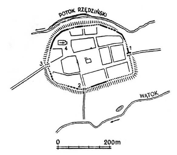
Tarnów was founded on a small hill on the border of the Sandomierz Lowland and the Carpathian Foothills, an area largely covered by forests in the Middle Ages, though some settlement actions had already taken place. To the south, the town was surrounded by the Wątok and Strusina streams, and to the north by the Rzędziński stream, both flowing into the Biała River valley to the west. The slopes descended steeply towards the streams to the north and south, but were also steep on the western side, where the Great (Upper) Suburb had formed in front of the town since at least the 15th century. On the eastern side of Tarnów, the Smaller or Lower Suburb lay, also known as Grabówka.
The perimeter of the defensive walls was adapted to the shape of the hill on which the town was founded. It outlined a fairly regular oval, forming right angle in the town’s southeast corner. Tarnów’s area exceeded 6 hectares, and the fortification line was over 900 meters long. A street ran along the town side of the walls. Its development began north of the collegiate church in the early 16th century, but initially the town authorities required access to the wall (a passage running in the building’s interior, in the houses adjacent to the wall). The parish church was located in the northwestern part of the town, near the fortifications, at the highest point of the hill, where it could serve as an observation point.
The defensive wall in Tarnów was built of bricks bonded in a Flemish bond (alternating header and stretcher) and set on a stone foundation of erratics. Its thickness at the ground level was between 1.5 and 2 meters, making it a massive structure. Its height is unknown, but it may have been considerable. The wall was originally topped with a battlement, which was blocked in the 15th century or during a major reconstruction in the first half of the 16th century, and transformed into a straight, roofed parapet with loopholes, probably modeled on the city wall of Kraków. A second, outer defensive wall was also built at that time, surrounding the town from the north and west, and possibly also from the southwest.
The fortifications of Tarnów probably did not originally have towers, as no records of them have been found. Their construction was documented only during the modernization of the walls in the first half of the 16th century. At that time, they primarily reinforced the younger outer wall, but at least one tower was also built in the inner wall (northern section of fortifications). Towers differed significantly: the slender ones in the inner wall represented a more traditional form, while the outer wall’s tower was a relatively modern structure for its time, adapted for the use of small arms. In the late Middle Ages, individual towers were cared for by guilds.
Tarnów had two main gates, into which streets leading from the corners of the market square converged. To the west was the Kraków Gate, and to the east the Pilzno Gate. Both were original, likely built along with the defensive wall. They were housed in rectangular towers with passages, protruding from the defensive wall on both sides, with the Pilzno Gate projecting 4.6 meters toward the town, measured from the inner face of the defensive wall. It measured 7.5 x 8 meters, with a 2.4-meter-wide entrance. In the first half of the 16th century, during the modernization of the fortifications, the gate towers were expanded with foregates. In addition to the main gates, there was the Minor Gate, located on the southern side of the town. Judging by the topography, it always served only as a pedestrian passage in the form of a postern. It was in operation since at least the mid-16th century and likely preceded several other wicket gates, built in the northeastern and southeastern parts of the circuit.
The outer defense was formed by moat and an earthwork, running at the foot of the town hills. It is unknown whether they were primal, but they existed before the sixteenth-century modernization, because chronicler Jan Długosz mentioned them. Further regulation and expansion of the system of moats and earth ramparts occurred in the 16th century. The moat was at least partially watered, probably from the Rzędziński stream.
Current state
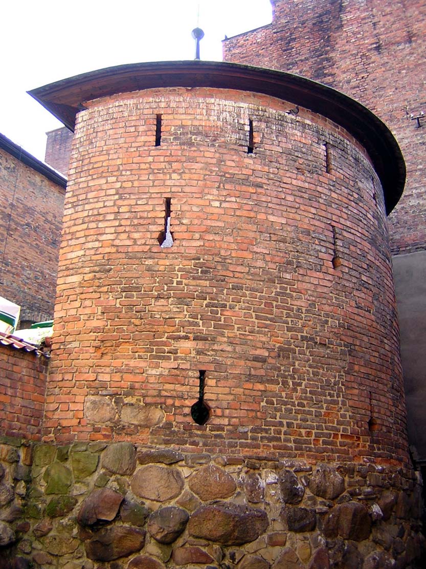
Existing fragments of Tarnów fortifications are almost completely embedded in later developments. Significant parts of the inner wall are preserved under the plaster in the rear walls of the houses in the north-west and north of the town, behind the Cathedral Square. In this area, on the property of Kapitulna 2, there is a tower, quadrangle at the bottom, round at the top, erected from a brick laid in a Polish thread. To the east, on the grounds of Basztowa 4, a fragment of the inner wall was preserved. The only place where you can read the thickness of the wall is a fragment from the east, at Pilsen Gate 4 street. This part is connected by the lateral, northern wall of the Pilzno Gate. Except for the remains of the inner wall, a part of the later outer wall was visible from the north, at the back of Wałowa street. The wall is mostly converted, the only well preserved element is a semi-circular open tower with artillery slits on the property of Basztowa 4.
bibliography:
Atlas historyczny miast polskich, tom V Małopolska, red. Z.Noga, zeszyt 6, Tarnów, Toruń-Kraków 2024.
Widawski J., Miejskie mury obronne w państwie polskim do początku XV wieku, Warszawa 1973.