
History
Strzelce Krajeńskie (German: Friedeberg, Vredeberge in the oldest form) was fortified with stone defensive walls after the town’s foundation at the end of the 13th century. The town was founded after 1272, when the castle of Conrad, the son of the Margrave of Brandenburg, burned down, built near the village of “Strzelcze”, after the Santok castellany found within the borders of Brandenburg, under the marriage agreement concluded between the Prince of Poznań Przemysł I, representing his daughter Constance, and Margrave Johan I and his son Conrad. The castle was destroyed by Constance’s brother, the Prince of Wielkopolska and later King Przemysł II. Conrad did not rebuild it, but founded a town in its place, which was quickly decided to be heavily fortified. Vredeberge was first recorded in 1286, while its fortifications were confirmed by a note from 1290, concerning the foundation of a monastery house for the Order of Augustinian Hermits, located near the town wall.
The fortified town managed to defend against the armed expedition of the Polish king Władysław Łokietek in 1326. Despite this, the fortifications were modernized in the 14th century, including the construction of new gate structures using bricks. In the late Middle Ages, as a result of the intensive development of firearms and siege art, the gates were expanded again, enlarged with necks and front gates, while at least one of the towers on the western side was raised and converted into a prison, and then a gunpowder warehouse. The expansion of the fortifications began no earlier than at the end of the 14th century, perhaps in the turbulent period of the first half of the 15th century, at a time when the town was a Teutonic Knights pledge from 1402 to 1454 as part of the New March.
In 1433, the Hussite troops of Jan Čapek ze Sán, supported by a Polish army commanded by the voivode of Wielkopolska, Sędziwoj from Ostroróg and Piotr Szafraniec, starost of Sieradz, stood under the town. Strzelce were abandoned by the crew of mercenary forces and the burghers remained alone. The invaders first proposed a truce, but using the weakening of the vigilance of the defenders, made a dig under the walls where they detonated the explosive charge and captured the town, which was then plundered and burnt. The wooden elements of the fortifications probably suffered damage at that time, but due to the stone and brick form of the towers and walls, the fortifications were probably repaired relatively quickly after the Hussites left.
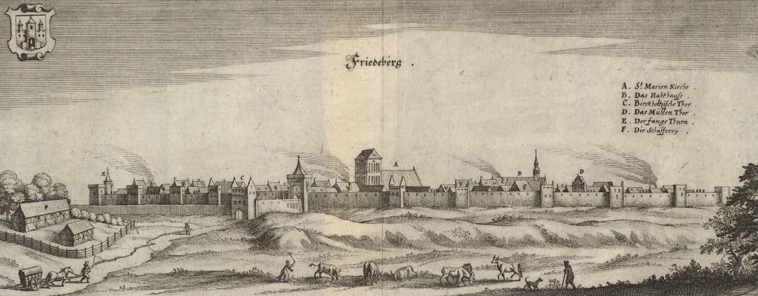
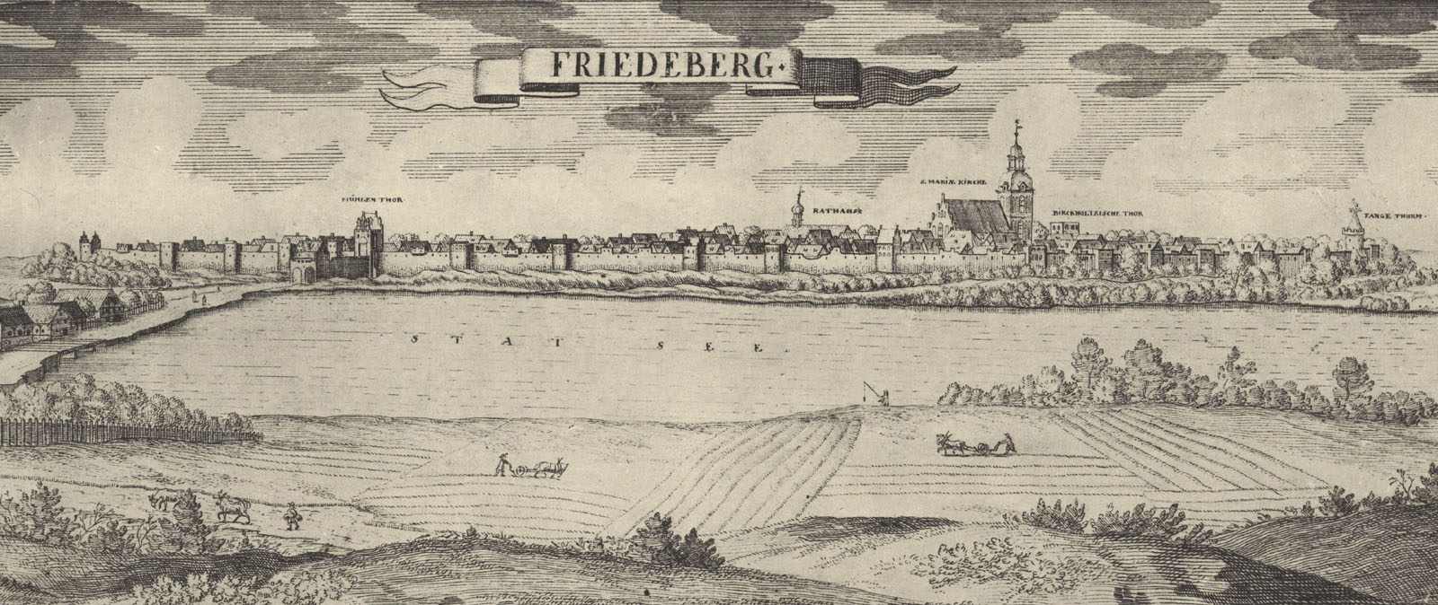
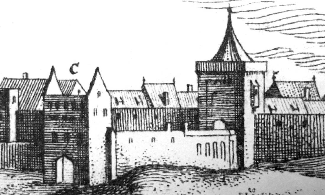
In the early modern period, the town fell into decline as a result of the Thirty Years’ War. In addition to public utility buildings, residential and economic buildings, the town gates and defensive walls also suffered. In 1697, thirteen damaged half towers were recorded. The destruction of the fortifications from the Thirty Years’ War and the destructions caused by the fires that hit the town were not removed at the beginning of the 18th century, which was presented in a drawing by Daniel Petzold showing the then panorama of the town.
In the 1730s, in the face of progressing devastation and unsuitability for military purposes, partial demolition of the fortifications was started, the ramparts were plowed, the moats were transformed into the gardens and some of the towers were demolished. Destruction of the walls and towers continued in the nineteenth century. Especially around 1864 the upper parts of the walls and towers were demolished, and in 1866 the Gorzów Gate was slightened. After the Second World War, a fragment of fortifications on the eastern side was demolished and residential buildings were added to the walls. In the 1980s, the Mill Gate was renovated, then in 1990 the Prison Tower and individual sections of the town wall were repaired.
Architecture
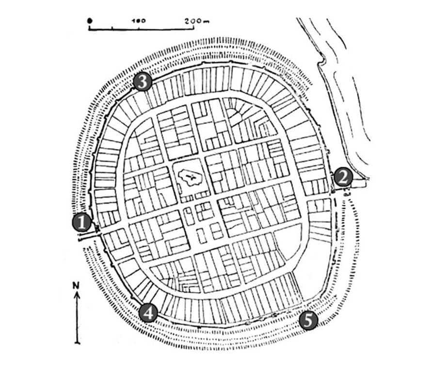
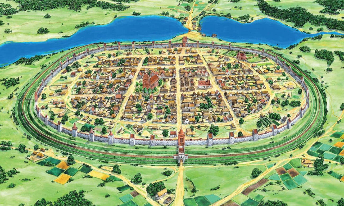
Strzelce was founded on a small elevation of land, surrounded by swamps and areas that were more or less wet in the Middle Ages, scattered among the hills and forests. From the north-east, the town bordered larger water reservoirs, connected by a stream flowing into the Noteć watershed. In the isthmus between the lakes, there was a route connecting Gorzów in the south-west with Dobiegniew in the north-east, the axis of which marked the location of the town gates. In addition to their protective function, the lakes were used, among other things, for the operation of water mills.
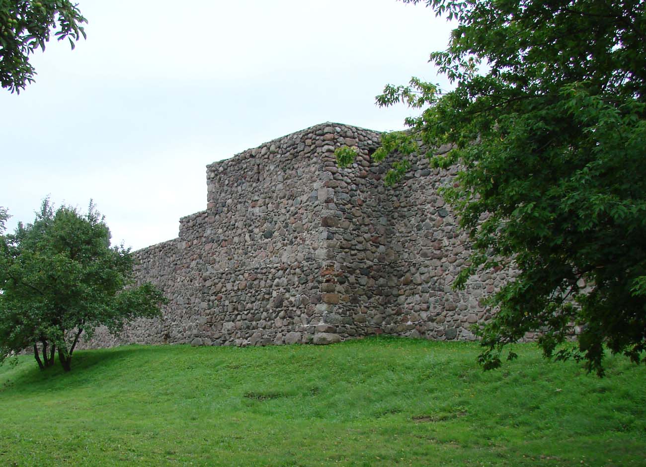
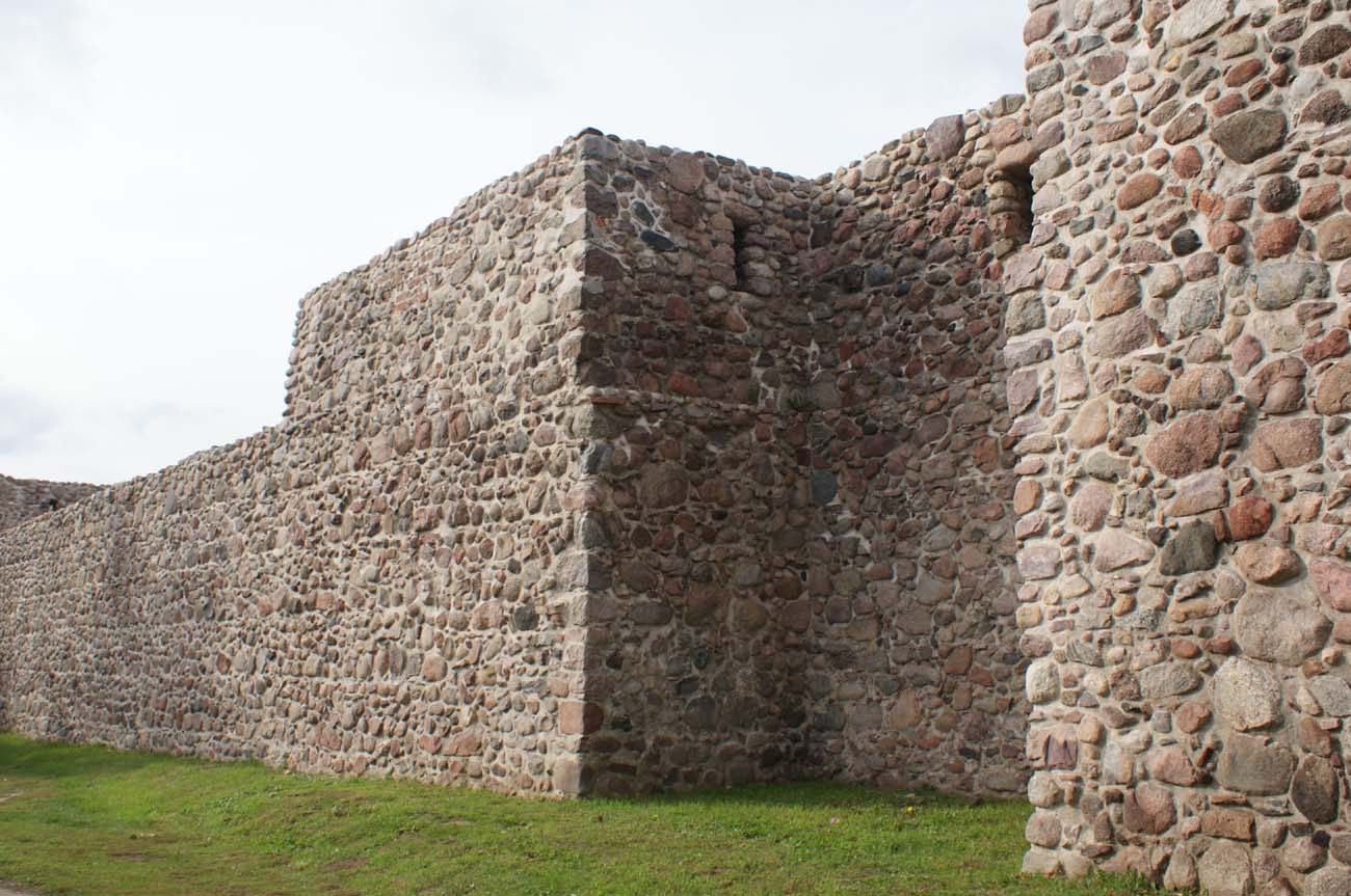
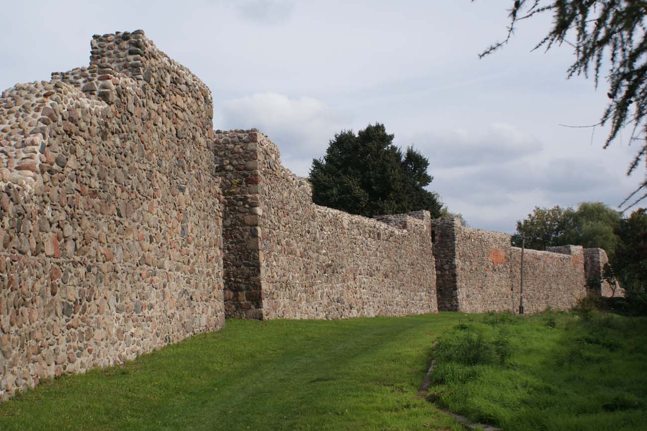
The circumference of the fortifications was founded on a projection similar to the circle and was about 1700 meters long. The walls were built of rough erratic stones, laid in layers of 60-120 cm thick, leveled with small stones and bonded with lime mortar with an admixture of animal blood and sometimes carrion. At the base, the walls are about 1.6 meters thick. The highest surviving section is 8.5 meters high, originally, it probably reached 9-10 meters. In their upper part, on the inner side there were timber porches allowing the defenders to move and the attack the invaders through the arrowslits. In parallel to the fortifications, there was an under-wall street, facilitating relocation in the face of danger.
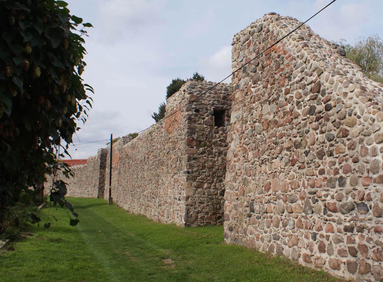
The wall was reinforced with thirty six or thirty-seven four-sided half towers, with inner dimensions of approximately 3.4-5.2 x 1.7-3.5 meters, opened on the town side and protruding about 2 meters in front of the neighboring curtains. The distances between them were between 26 and 56 meters, that is no more than double the distance of a successful shot from the crossbow. A more regular arrangement of towers was achieved in the western, more endangered part of the perimeter, where the distances between them ranged from 27 to 31 meters. Originally, it had two or three floors used for shooting through the arrowslits straight ahead or from the side, with internal communication via a brick staircase, leading to the second floor and further using timber ladders. In the top floor the towers had to be connected with a porch placed on the defensive wall. In the upper floors of the half towers there were narrow shooting holes. These arrowslits were placed one and more rarely two on the long sides, and one on the short sides. Perhaps the towers were originally covered with timber hoarding. In some of the towers, a roofing in the form of a tall hip roof or a gable roof appeared later. In Strzelce, there were also bartizans, located on the eastern side, hung on the crown of the walls.
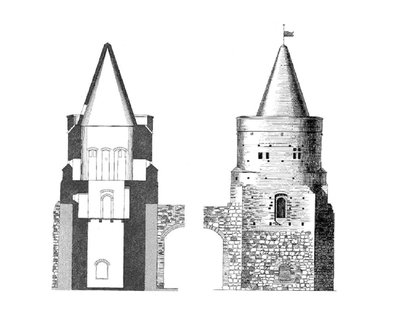
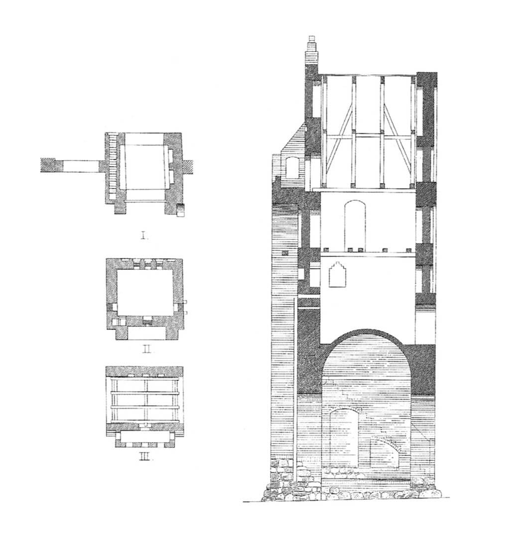
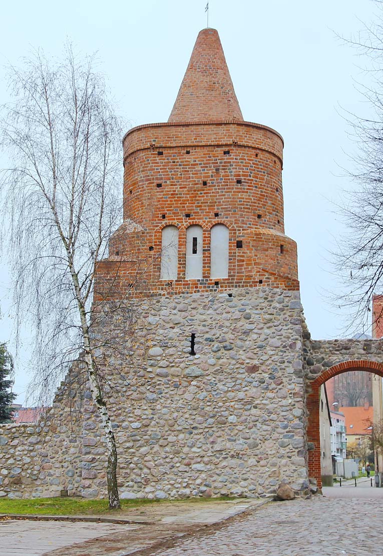
In the second half of the fourteenth and fifteenth century, some of half towers were built up and closed from the inner, urban side, serving military, penitentiary, warehouse or residential purposes. An example of this is the Prison Tower (Powder Tower). It was built on a quadrangular plan, close to a square, 4.6 meters wide and 6 to 8 meters long. In the lower part it had a rectangular form, passing at a height of about 8.5 meters into the form of a flattened cylinder. In the finial there was a conical ceramic helmet and an observation platform. In the northern façade a decoration composed of blendes in a triforial pattern was made. The interior was divided into three floors, which were once connected by timber stairs. Each of them contained one room lit by small slit openings. The entrance to the tower was from the town side, at the level of the first and second floors.
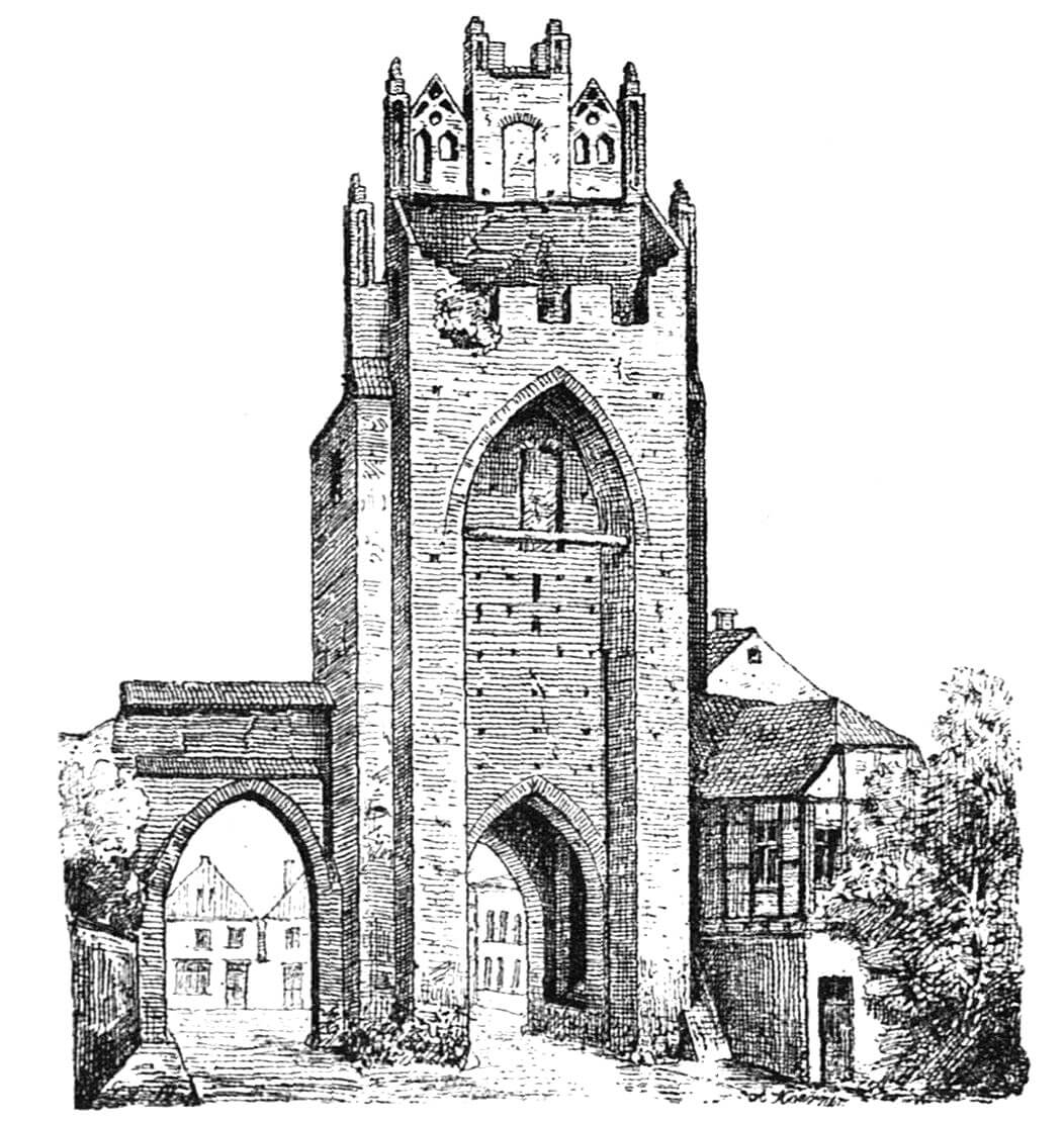
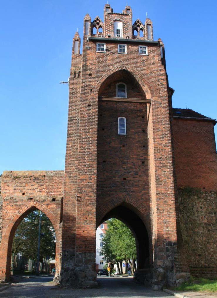
Two gates led to the town: Mill Gate (also called Drezdenecka) on the east side and Gorzów Gate from the west. The gates originally had the form of cuboids and were covered with a gable roof or an open terrace. At a later stage, they were raised with brick upper parts, created with decorative gables and closures in the form of gable roofs. The Gorzów Gate on the town elevation was decorated with numerous pointed blendes, while on the opposite side it had a recess for a portcullis, above which there was an opened porch. On the side wall there was a latrine projection. The ground floor of the gate housed a passage, vaulted one or covered with a beamed ceiling, while the upper storeys housed rooms for guards. Communication between the individual storeys was provided by brick or wooden staircases and ladders. In the late Middle Ages, the Gorzów Gate was expanded with a foregate in the form of a slightly lower gatehouse on a rectangular plan, connected by a neck to the main part of the gate.
The Mill Gate was built on a quadrangular plan, approximately 8.4 metres long and 6.8 metres wide. On the outside, it was equipped with a very high, pointed recess used to pull up the portcullis, and on the town side it was decorated with longitudinal, segmentally ended blendes, narrower in the gable and arranged in a pyramidal shape. The portcullis operated in guides, using chains or ropes equipped with special weights. The passage in the ground floor, 3.3 meters wide and 4.5 meters high, was articulated on the sides by pairs of shallow, high recesses with segmental arches. The first floor was accessible by a narrow staircase in the thickness of the wall, the entrance to which was from the town side. Ladders or timber stairs were probably used higher up. The room on the third floor was equipped with a latrine and heating, so it must have served the gatekeeper. Above it, there was a floor with access to an open defensive porch protected by a battlement. The late medieval foregate of the Mill Gate was similar to the Gorzów Gate, but the outer gatehouse had two passages next to each other. Perhaps in connection with this solution, a second pointed passage was made in the wall next to the main gate tower.
The external protection of Strzelce was provided by ramparts, perhaps additionally reinforced with a wooden palisade, as well as a double moat filled with the waters of the Upper and Lower lakes, the task of which was to make difficult for the besiegers to access the walls. The earth dig during the construction of the moat was also used to build ramparts along the banks. The moats were set back from the curtain wall by about 11 meters. They were slightly over 9 meters wide and 3.2 meters deep in the case of the outer moat and 3.6 meters deep in the case of the inner moat, which ensured that they did not silt up or become overgrown. The latter was also prevented by the constant deepening and securing of the banks.
Current state
The ring of the walls has been preserved almost entirely today, but walls are in many places lower than the original high. The highest preserved section on the northern side is 8.5 metres high, the remaining fragments reach 3-4 metres in height. Almost all half towers have survived, but are lowered to a similar extent as the neighboring walls. The most valuable element is the Mill Gate and the Prison Tower. The first one have survived without any major early modern transformations, almost intact, but without the foregate and neck which were removed in 1736. In 2012, a replica of its portcullis was made, based on the traces left on the elevation. The defensive floor of the gate above is currently bricked up, filled with three windows in the place where the open porch was situated. On the opposite side, additional windows were made in the blendes in the 19th century. The Gorzów Gate did not survive, demolished in 1866, but fortunately it is known from its iconography and photographs taken before its demolition.


bibliography:
Fijałowski K., Kaźmierczak P., Fosy średniowiecznych fortyfikacji w Strzelcach Krajeńskich [in:] W cieniu strzeleckich murów. Studia nad dziejami i dziedzictwem kulturowym Strzelec Krajeńskich, Strzelce Krajeńskie 2020.
Graliński G., Strzelce Krajeńskie. Historia jednego miasta, Strzelce Krajeńskie 2005.
Kowalski S., Zabytki architektury województwa lubuskiego, Zielona Góra 2010.
Kustosz H., Skaziński B., Baszta Więzienna w Strzelcach Krajeńskich [in:] W cieniu strzeleckich murów. Studia nad dziejami i dziedzictwem kulturowym Strzelec Krajeńskich, Strzelce Krajeńskie 2020.
Lukas E., Średniowieczne mury miejskie na Pomorzu Zachodnim, Poznań 1975.
Ratajczak T., Średniowieczna architektura bramy Młyńskiej w murach obronnych Strzelec Krajeńskich [in:] W cieniu strzeleckich murów. Studia nad dziejami i dziedzictwem kulturowym Strzelec Krajeńskich, Strzelce Krajeńskie 2020.
Skaziński B., Lubuskie Carcassonne: średniowieczne fortyfikacje Strzelec Krajeńskich, Dębno 2009.
Skaziński B., Średniowieczne fortyfikacje Strzelec Krajeńskich [in:] W cieniu strzeleckich murów. Studia nad dziejami i dziedzictwem kulturowym Strzelec Krajeńskich, Strzelce Krajeńskie 2020.
Studia nad początkami i rozplanowaniem miast nad środkową Odrą i dolną Wartą (województwo zielonogórskie), red. Z.Kaczmarczyk, A.Wędzki, tom 1, Zielona Góra 1967.