
History
In 1290, the surrounding lands were granted to the Knights Templar by Prince Przemysł II, after which the Knights Hospitaller took them over in 1312. The Drahim Castle was built by the Knights Hospitaller in 1360-1366 on the site of the earlier hillfort of the slavonic Drawian tribe, or perhaps on the first wood and earth fortress of the Hospitallers from the middle of 14th century. Its name (“Drayhem”) was first recorded in documents in 1368.
After the taking by Poland in 1366 of the neighboring castle of the Hospitallers in Czaplinek, the seat of the commandry was located in Drawsko. Two years later Drawsko was attached by Kazimierz the Great to the Crown, but the Hospitallers continued to hold the castle as a fief. Their attempt to conduct their own policy, disloyal to Polish suzeraincy, caused in 1407 the punishment invasion of King Władysław Jagiełło during which, after a few days of siege, Polish knights have conquer the castle. Hospitallers were expelled, and Jagiello established a castle district in Drawsko.
The Polish starosts from Drahim became a terror for merchants traveling by the so-called March Route. This led to the intervention expedition of the townsmen from Drawsko against the starost of Dubisław, which ended in 1422 with the capture of the castle and then handing it to the Teutonic Knights. The betrayal of a crew member occupying the stronghold allowed the Poles to recapture Drahim, although in the following year the Grand Master of the Teutonic Order taxed the inhabitants of Gdańsk in order to finance the expedition to Drahim, which was finally recaptured by the Poles in the late autumn of the same year.
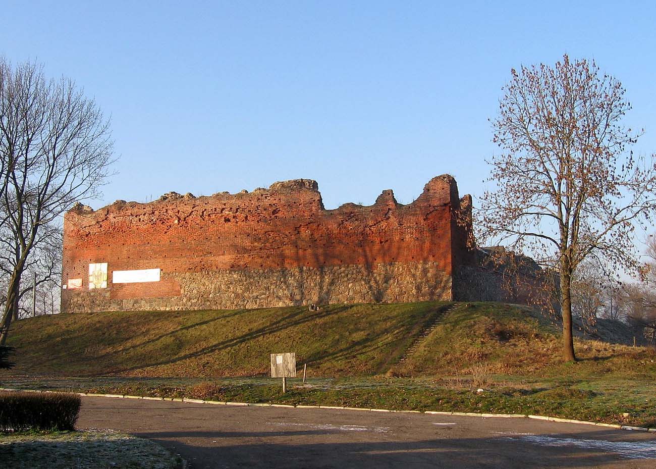
The victory of Poland in the thirteenth-yeares war and the decision of the II Peace of Toruń made that the Drahim castle from the role of a strategic fortress went down only to the seat of the administrative district. In the 16th century it was destroyed by fire, after which it was rebuilt after royal order by Joachim Natzmer after 1535. Construction works at the castle were also carried out by his son Wilhelm before 1562, as a result of which the perimeter walls were renovated and two new wooden buildings were erected. In 1657, Castle Drahim was pledged for royal debts to electors of Brandenburg, who eventually took it over in 1668, after the death of the last starost, Stanisław Rewery Potocki. In 1758, the castle was destroyed by the fire, and building materials from the abandoned fortress were used to build a nearby church.
Architecture
The stronghold prior to the castle had the shape of an ellipse measuring approximately 46 x 50 meters. It was located on the isthmus between lakes Żerdno and Drawsko, which protected it from the east and west. From the north and south the moat with a water depth of up to 5 meters cut off the stronghold from the land. Above the north moat there was a timber bridge. The height of the ramparts was between 6 and 8 meters, the width at the base was 10 meters, and the crown of the ramparts had about 2.6 meters. From the inside, the ramparts were reinforced with a wooden structure, while from the outside, covered with stones, which protected from the destructive action of water. Within the stronghold there were residential houses built of wood in a log structure characteristic of Slavic tribes.
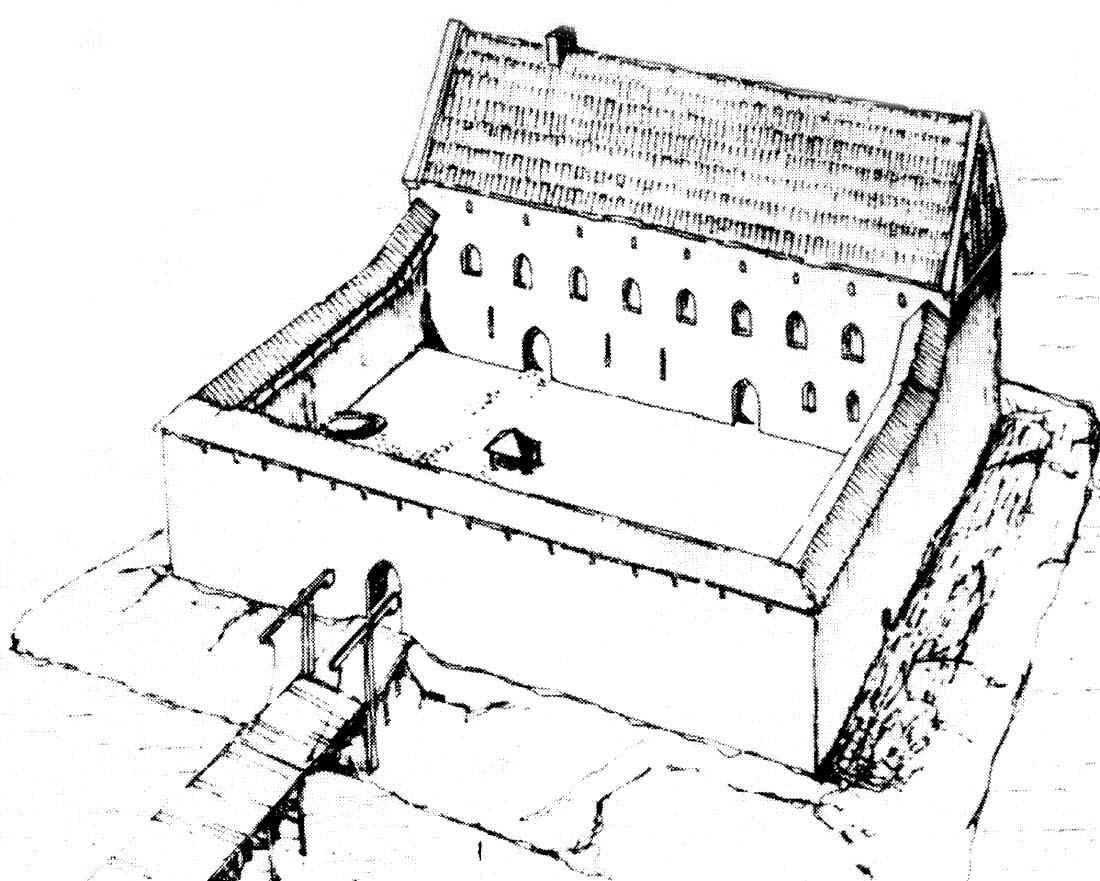
The castle was made of brick on stone foundations, placed on the leveled upper part of ramparts and raised inner courtyard of the former stronghold. The face of the wall was tied in a Flemish bond, while the core of the wall was filled with erratic stones and brick debris, flooded with lime mortar. It had the shape of a regular quadrilateral measuring 41 x 46.5 meters, wall thickness up to 2.5 meters and a height probably around 11 meters. The crown of the wall was covered by a porch for defenders (suspended at the height of 9 meters in sockets for beams) and arrowslits located at a distance of about 2.5 meters from each other. In the northern curtain there was asymmetrically an entrance gate, and next an extended four-sided gatehouse. The gate led across the bridge over the moat and further to an outer ward in a small peninsula, size of 70 x 30 meters, separated from the mainland by the river Drawa. In the western curtain there was a side wicket leading to the road that was going around the castle. The moats were 5 meters deep and were reinforced with a wooden structure, and the edges themselves with a stone cladding. The bridge over the northern moat was built of wood and supported on massive pillars.
At the southern curtain stood the main house with dimensions of 11.5 x 37.5 meters. It filled the entire curtain, was three-story and without cellars. The ground floor served as an economic and prison function, covered with a hard floor made of clay. In the eastern part there was a minting workshop and a kitchen, in the western – prison made of erratic boulders, 8 meters deep, on a plan of a circle with a diameter of 3.5 meters, tapering to only 1 meter on the bottom. On the first floor residential chambers were located, and above them a storage and warehouse storey. The interiors were covered with flat, wooden ceilings, lit only from the courtyard side. The window openings at ground level were in the form of high slits and they were only pierced from the courtyard side.
At the courtyard there was a well and a stone, circular trough for horses. In the north-eastern corner, a cellar measuring 4 x 8 meters with a large number of crossbow arrowheads was discovered. Nearby, traces of iron ore melting and furnace were also found, as well as a 4 x 8 meter cellar from the turn of the 14th and 15th century, which was a relic of a blacksmith’s workshop.
Later reconstructions added two half-timbered houses for the staroste and his assistant on the west and east wall in the courtyard, as well as two wooden, corner towers. The buildings received three floors, topped with planks. Another half-timbered building from the 16th century was the gatehouse in which there were oak door and a drawbridge with a counterweight. It was built on a rectangular plan with dimensions of 5.5 x 14 meters and set on densely piled piles, over which it rose to 5.5 meters high. It enclosed the entrance to the castle at the northern curtain, as it was entirely located outside the wall.
Current state
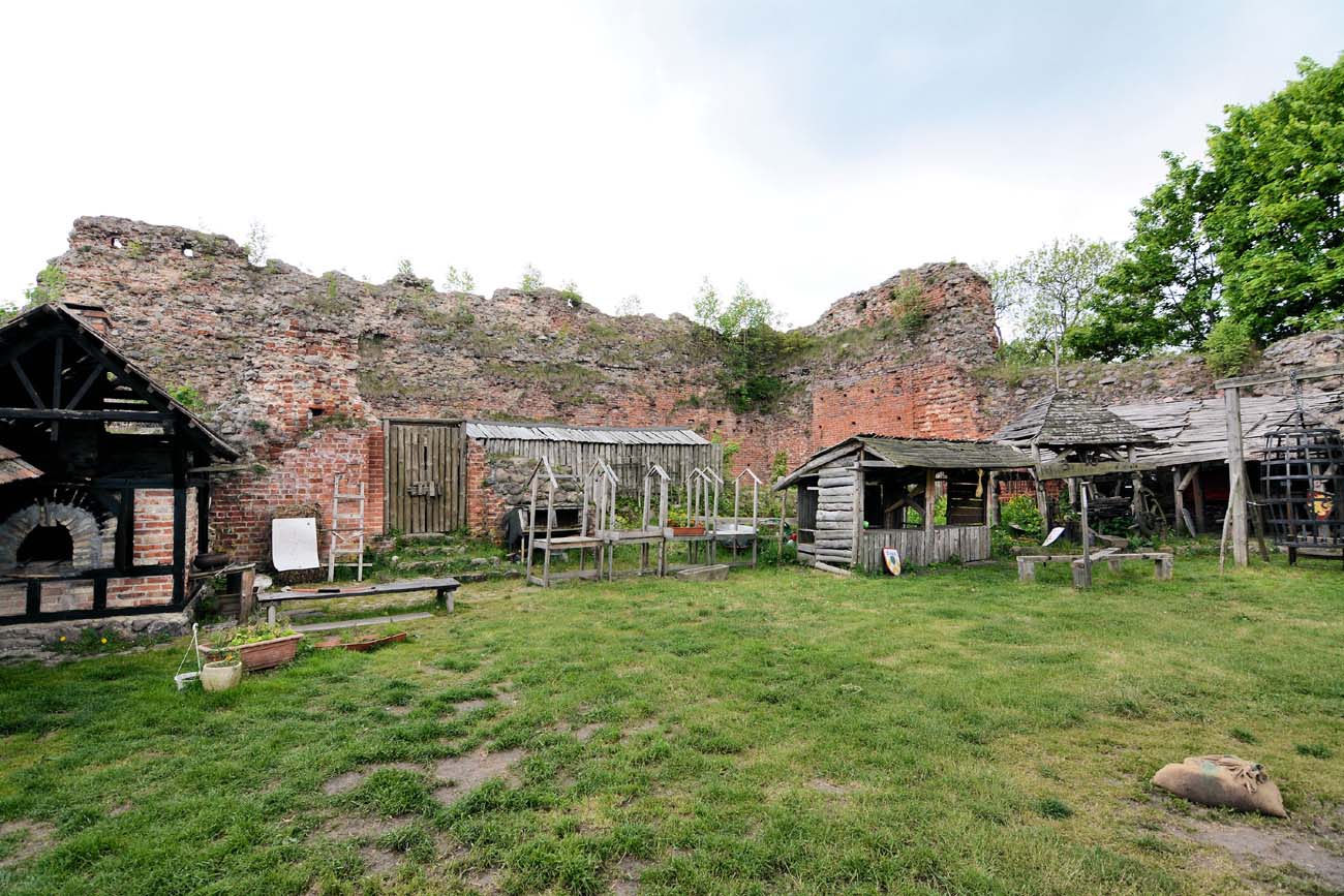
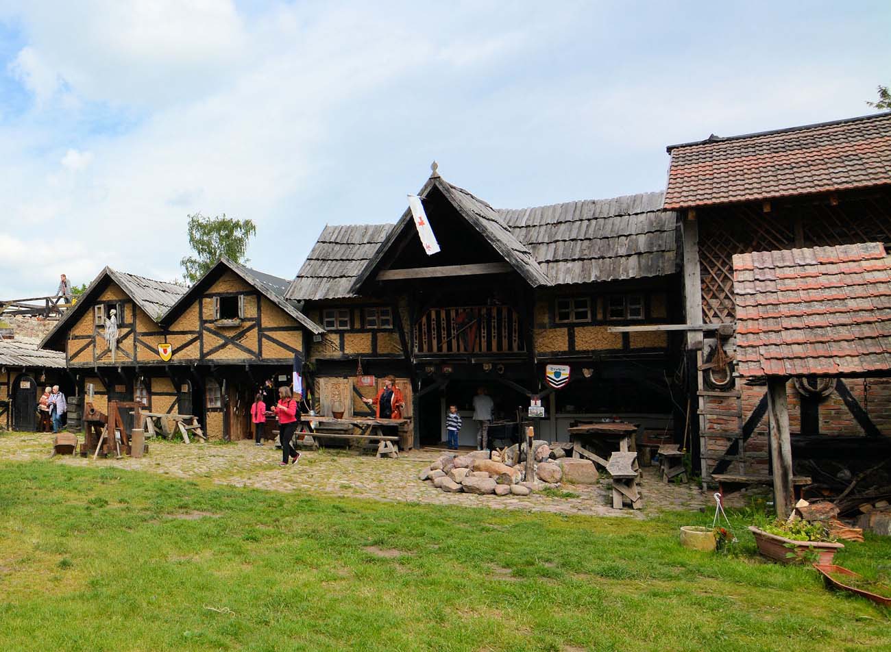
The castle has survived in a state of ruin with full outer walls with heights varying from 4 to 10 meters and remnants of the walls of the main house. Currently belongs to the private Museum of Automotive and Technology and is open to the public. Information on hours, prices and cultural events can be found on the official website here.
bibliography:
Janocha H., Lachowicz F., Zamki Pomorza Środkowego, Koszalin 1990.
Leksykon zamków w Polsce, red. L.Kajzer, Warszawa 2003.
Pietrzak J., Zamki i dwory obronne w dobrach państwowych prowincji wielkopolskiej, Łódź 2003.
Radacki Z., Średniowieczne zamki Pomorza Zachodniego, Warszawa 1976.
Tomala J., Murowana architektura romańska i gotycka w Wielkopolsce, tom 2, architektura obronna, Kalisz 2011.