
History
From the early Middle Ages in Sławno there was a Pomeranian wood and earth stronghold (hillfort), which was the center of the Sławno Land, and at the turn of the twelfth and thirteenth century, the capital of a separate duchy. From about 1230 to 1308, the Sławno Duchy belonged to Gdańsk Pomerania, except for the years 1270-1273, when Wisław, prince of Rügen, ruled it. In 1308, the Słupsk and Sławno land were taken over by the Brandenburgians and handed over in the fiefdom to the Pomeranian family of Święcowie, who founded the town called „Nova Zlavna” in 1317. IIt received eight years of tax exemption, probably used for the construction of timber and earth fortifications.
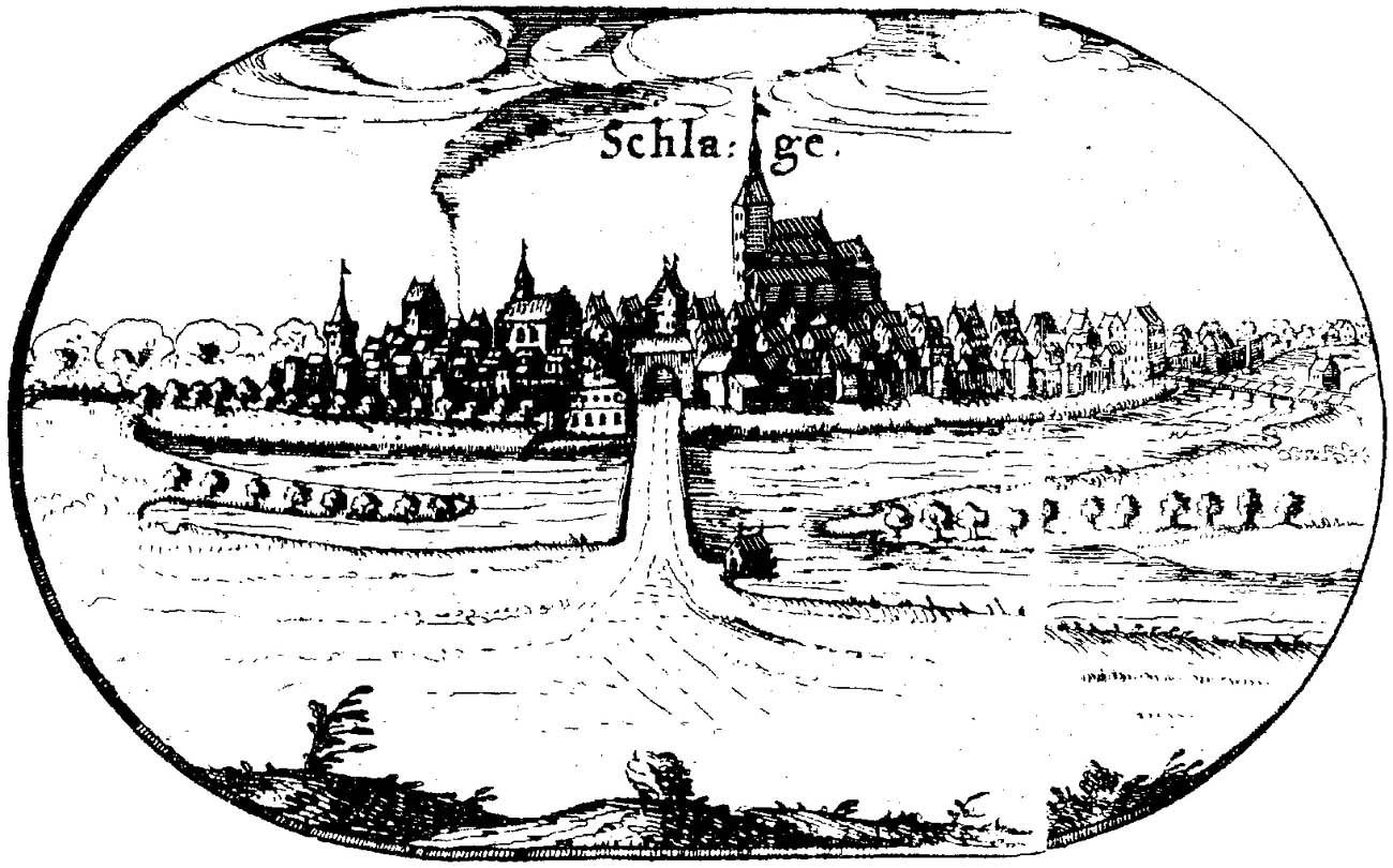
The first record of brick fortifications of Sławno (Schlage, Slage, later Schlawe) dates back to the year 1400, when the town belonged to the Duchy of Słupsk. Most probably, the construction of the town walls begun in the second half of the 14th century. In 1453 the Koszalin Gate was mentioned, and in 1458 the Słupsk Gate.
The successful development of the town was only slightly hindered during the Thirty Years’ War. In the eighteenth century, the condition of the walls was already described as bad, although in the years 1741 – 1787 they were subjected to renovation works. However, around the middle of the 19th century, demolitions of medieval fortifications began. In 1913, the Koszalin Gate was renovated, and before 1939, the Słupsk Gate was repaired.
Architecture
The ring of fortifications outlined the shape of an oval inscribed in the bend of the Wieprza River and its branches. Sławno was surrounded from the south by a canal running from the Wieprza and connecting to the Moszczenica River in the north. In the south-east there was a canal called Timber, while from the south-west a moat was dug. In addition, additional protection was provided by the wet, difficult-to-pass areas on the Wieprza River. Two bridges led to the town through the canal and the Wieprza backwaters: to the Koszalin Gate and the Meadow Gate.
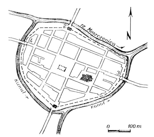
The area of the town was about 10 hectares, and the length of the wall line was 1250 meters. The main communication axis ran from south to north and crossed the market square, connecting with it at opposite corners. From the inside of the walls, a street under the wall ran around the town. The parish church was not erected along the perimeter of the walls, from which it was separated by plots of urban buildings. Due to the later demolition, it is not certain whether the town had a full perimeter of brick fortifications. It is possible that only a wooden palisade was built in places, and the Wieprza River and its backwaters provided protection.
The defensive wall was reinforced with rectangular half towers, opened from the town side. They were probably protruded in front of the neighboring curtains, from which it were higher by a maximum of one storey. The lack of the rear walls of the towers ensured lower costs and a faster construction process, as well as protection in the event of a fragment of the fortifications being seized by attackers (it allowed firing from the town side). The exception was the Prison Tower founded on a circular plan and topped with a conical roof. It probably protected one of the western corners of the Sławno.
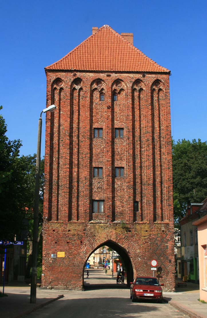
The town had three gates. Koszalin and Słupsk gates were located on the main communication route, in the southern and northern parts of the town, respectively. The third gate called Meadow Gate, located in the eastern part of the town, led to suburban pastures. In addition, there was also a Field Gate in the western part of the town, but it was probably only a postern leading to farmland belonging to the townspeople.
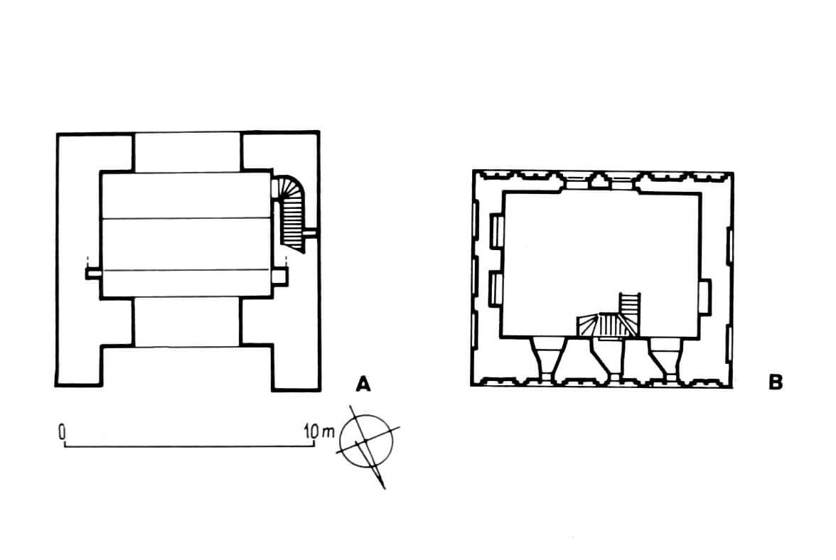
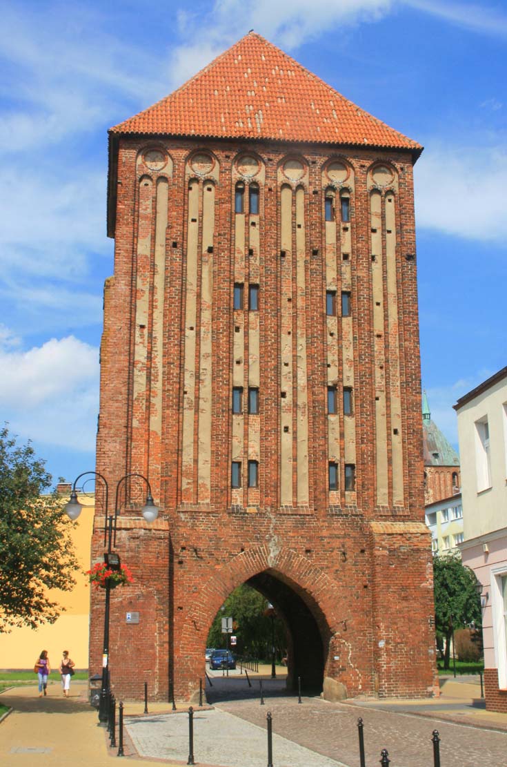
The two main gates were built on a plan similar to a square, divided into five storeys, built of bricks with an anachronistic in the 15th century monk bond. The four upper floors of the gates were divided by slender, bipartite blendes, and the lower floors had ogival gate passages. The gates were topped with roofs set on stepped gables. In the facades facing the foreground, there were arrowslits, and on these sides there were also foregates. Vertical communication between the ground floor and the first floors was provided by stairs in the thickness of the wall, and ladders or wooden stairs above.
Current state
To this day, only the Słupsk Gate and the Koszalin Gate have survived from the fortifications of Sławno. They are not used or accessible to tourists, only by the old gate passages led the modern roads. In the early modern period, their arrowslits were enlarged to the form of windows, and the gables have not been preserved. The eastern part of the town is still surrounded by the Wieprza River canal, and from the north it is limited by the Moszczenica River, which served as a moat.
bibliography:
Architektura gotycka w Polsce, red. M.Arszyński, T.Mroczko, Warszawa 1995.
Jarzewicz J., Architektura średniowieczna Pomorza Zachodniego, Poznań 2019.
Lukas E, Średniowieczne mury miejskie na Pomorzu Zachodnim. Poznań 1975.
Pilch J., Kowalski S., Leksykon zabytków Pomorza Zachodniego i ziemi lubuskiej, Warszawa 2012
Ptaszyńska D., Miejskie mury obronne w województwie koszalińskim, Koszalin 1974.