
History
In 1235, the Pomeranian prince Barnim I gave the Templars the Banie Land, thanks to which the monks at the beginning of the 40s of the 13th century began building their commandry, situated on the Rurzyca River. It was a type of a farm court and had primarily an economic function. Its defense was due to its location in a swamp, not from extensive fortifications. Its main task was to provide income to the superior center. The commandry’s crew was probably not very numerous and consisted of a few brother-knights, a few servant-brothers and peasant families and craftsmen living next to them. Initially, the majority of the court’s inhabitants were probably newcomers from older monastic houses of the German province. Among them were also lower-level brothers and lay helpers. With time, the staff of the facility was supplemented by members of knight’s families who entered the order, living in the Pomeranian region.
The Templars who came to Rurzyca began to develop the site by erecting a stone chapel and the main residential building before 1248 (the date of the first visit of the diocese superior, Bishop William). The latter was probably an object entirely made of wood, or built in a timber-frame structure which was spreading in this part of Europe, and was faster to build and consumed less costs. Before the buildings were erected in Rurka, the function of the main seat could have been performed by the manor house, which the brothers had to have in Banie, where there was already a church where the liturgy could be held.
After the donor’s death, his son, Bogusław IV, being aware of the danger of the occupation of the Duchy’s border by the Order, and remembering about his father’s fights with the Knights Hospitaller in the Stargard region, began to fight the Templars of Rurka. In 1282, they received the patronage of the church in Chojna from the Brandenburg margraves Otto IV and Konrad I, becoming de facto border watchtower of the Marche. Border fights were temporarily interrupted by the truce of 1284 concluded in Czworokół, in which Bogusław IV made a promise that he would not harm the monks. However, after a few years, especially after 1288, when the bishop of Kamień died, the protector of the Templars from Rurka, the fighting broke out again and this time the commandry suffered considerable damages and its property was confiscated. In 1291, the Knights Templar issued a complaint to Pope Nicholas IV, who excommunicated Bogusław. The prince did not care too much and ordered the envoys carrying the anathema to be imprisoned. The conflict ended with the dissolution of the Templar Order in 1312. Their last commander in Rurka was Jordan Ecbeck of Lietzen, involved in the development of the town Banie belonging to the brothers.
Pope Clement V decided to hand over the goods of the Knights Templar to the Knights Hospitaller. The handover took place peacefully, and the Knights Templar in Brandenburg were not judged and were not excommunicated, although the process was prolonged, as Pope John XXII in the following years reprimanded the bishop of Kamień for the goods of the Templars. The new owners settled in Rurka around 1329, and the first known superior of the commandry was Henning von Buk, mentioned in documents from the 1330s.
In the 70s of the fourteenth century, the commander of the Knights Hospitaller Wilhelm Holsten entered into a conflict with the knights family of von Wedel, who took the opposite side of the conflict led by Margrave Otto, who ruled New March and was the last representative of the Wittelsbach family, with the then Emperor Charles IV of Luxembourg, whom Pomeranian dukes were allies. In the winter of 1373, a group of several dozen wranglers left Chojna, heading for the commandry in Rurka. At the head of the local knights, townspeople and, interestingly, even peasants from Barnkowo, was the mayor of New March, Hasso von Wedel. The invaders had to act by surprise, because the losses of the Knights Hospitaller were huge. The buildings of the court were burnt, sheep, cows, horses, wood for building materials and a valuable copper vat for brewing beer were stolen. The chapel was also desecrated by robbing the host and damaging the baptismal font. The building was protected from complete destruction only by solid granite walls. The Hospitallers left the destroyed commandry, but in the area of Rurka there was still a farm belonging to the monastic property. The threats from both the Brandenburg and the still dissatisfied Banie townspeople made the monks aware of the need to build a new, more fortified seat, which after 1377 became the castle in Swobnica (Wildenbruke).
In the course of subsequent conflicts that the Knights Hospitaller waged in the 15th century, first with the burghers of Banie, and then during the wars of succession to the Szczecin dukes, in 1472 the court in Rurka became a place of important negotiations between the envoys of the Pomeranian dukes and the Elector of Brandenburg. The results were awaited by the new Brandenburg elector, Albrecht Achilles, staying in Chojna, and the Pomeranian dukes: Eric II and Warcisław X, who were staying in Banie. Finally, two months later, peace was concluded. The lands conquered earlier by the elector were to remain under his authority, and the Pomeranian dukes had to pay tribute to him, which meant that the commandry in Swobnica together with Rurka, were temporarily within the borders of Brandenburg. Probably during this period, the former monastic chapel finally ceased to fulfill its sacral functions due to the construction of a new church in a nearby village.
After the dissolution of the Order of Hospitallers in 1648, the property and the chapel were taken over by the Margraves of Brandenburg, and the church was abandoned and turned into a granary. In the second half of the nineteenth century, it was rebuilt into a distillery, while the surrounding areas were drained after a change in the course of the river. After World War II, the chapel was further devastated. In 1999, archaeological research around the chapel and security works were undertaken.
Architecture
The commandry in Rurka (German: Rörchen) was situated on a slight flattening of the hill, protruding above the surrounding marshes and peat bogs in the east, and also surrounded by canals and the waters of the small river Rurzyca on the west side. It had an elliptical shape measuring 70 x 50 meters with a longer axis on the north-south line. In the north-eastern part there was the mouth of the dyke connecting the commandry with the road. In the northern part, however, there was a pond, fed by the water of the Rurzyca River through a channel.
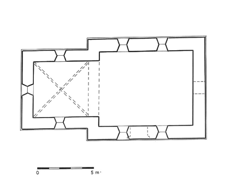
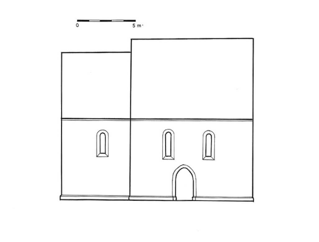
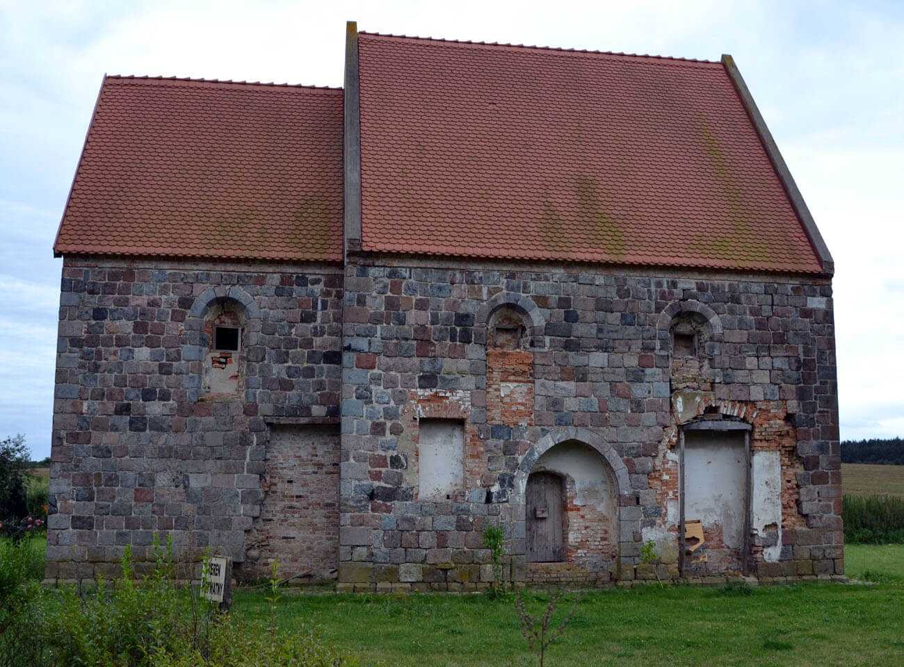
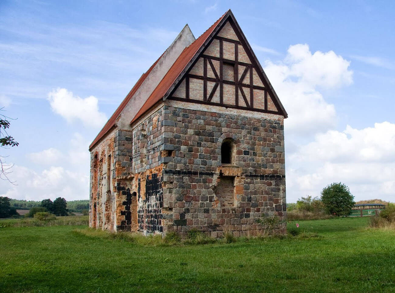
The chapel was situated on the southern edge of the square with irregular buildings. It was erected as a small, orientated, aisleless building with overall dimensions of 16.5 x 8.8 meters (nave 10.7 x 8.8 meters), with a narrower, straight ended chancel of 5.8 x 7 meters, slightly lower (about 6 meters) and narrower than the nave. Both parts were topped with gable roofs covered with tiles. The walls of the church were made of granite blocks, arranged in regular layers. They were distinguished by the precise way in which the granite squares were machined to form the original outer face. The different layers of the walls were distinguished by the variety of colors of the stones. In several places on the stones there were carved signs that can be considered as a house marks of contractors representing workshops. The walls were built in a medieval technique similar to the opus emplectum. Their thickness ranged from less than 1 meter in the choir part to 1.1 meters in the nave part. The structure rested on a chamfered pedestal, typical of the then Pomeranian architecture. The center of the wall was filled with unworked stones, granite small pebbles and poured with lime and sand mortar. From the inside, the face of the walls was formed by small pebbles, sometimes also ashalr, probably originally covered with plaster.
In the western gable there was an oculus, and in the northern wall of the chapel’s nave there was a slightly pointed entrance portal leading from the courtyard. Two windows of the northern wall of the nave were closed with semicircular arches, slightly narrowing towards the center of the wall, similar to the windows in the southern wall. Single windows of a similar form were also placed in all walls of the chancel, while the window in the eastern wall was placed slightly lower.
The interior of the nave was covered with a flat, wooden ceiling, while the space of the chancel was covered with a cross vault based on granite corbels placed in the corners of the room. The nave was separated from the eastern choir by a low arch. The original internal facades were covered with plaster, similarly plastered, and also decorated with painted decorations was the vault in the presbytery. In the western part of the nave, a stone wall, connected with lime mortar was discovered, placed along the north-south axis, in the upper part finished with a layer of granite squares facing the presbytery. The wall was put in by the builders after the chapel was built. It is not certain what its function was, it could have been the foundation of the gallery, on which a modest scriptorium or sacrarium containing relics was placed.
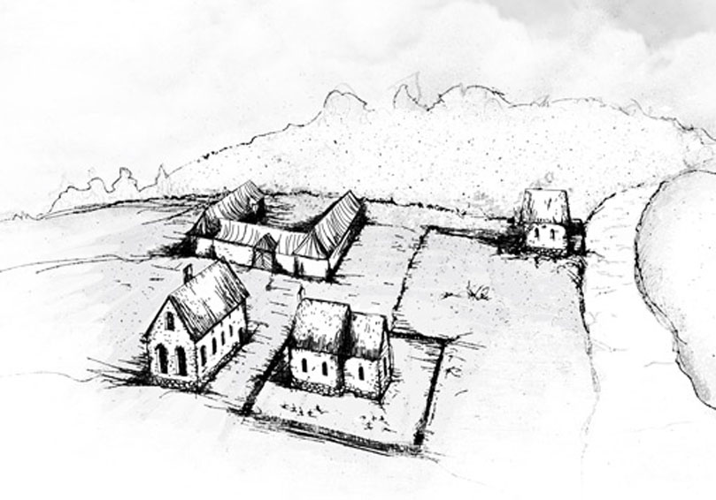
The chapel, together with the fenced cemetery area and the nearby timber residential building, formed a religious sacred zone. The entrance in the northern wall indicates that there was a courtyard on this side, around which the remaining farm buildings were located, including a barn, a stable, a pigsty, a granary and a mill by the river. At the turn of the thirteenth and fourteenth centuries, a new brick residential building was erected, located along the longer axis parallel to the chapel wall. It probably had a rectangular plan measuring 12 by 20 meters. In the first half of the fourteenth century, the Knights Hospitaller continued the expansion of the main building of the court, they also tried to increase the defensive values of the commandry. It was most likely during this period that they dug a shallow moat, fed with water from Rurzyca, several dozen meters north of the chapel, running along the border of the commandry buildings.
Current state
Despite numerous transformations of the elevations, the Rurka chapel retained a clear shape of the early Templar monastic chapels, probably in the best condition in Eastern Europe. In the early modern period, the area of the former commandry was raised, leveled and largely covered with cobblestones. No other commandry buildings are now visible there. Currently, the chapel is privately owned and undergoing further renovation.


bibliography:
Kołosowski P., Późnoromańska kaplica w Rurce na Pomorzu Zachodnim w świetle badań dziejów założenia zakonnego templariuszy [in:] Architektura romańska w Polsce. Nowe odkrycia i interpretacje, red. T.Janiak, Gniezno 2009.
Piasek D., Średniowieczne kościoły granitowe Pomorza Szczecińskiego i Nowej Marchii, Gdynia 2023.
Pilch J., Kowalski S., Leksykon zabytków Pomorza Zachodniego i ziemi lubuskiej, Warszawa 2012.
Radacki Z., Średniowieczne zamki na Pomorzu Zachodnim. Suplement do monografii z 1976 roku, “Materiały zachodniopomorskie. Nowa Seria”, t. II – III, zeszyt 2, 2005/2006.
Radacki Z., Średniowieczne zamki Pomorza Zachodniego, Warszawa 1976.
Świechowski Z., Architektura granitowa Pomorza Zachodniego w XIII wieku, Poznań 1950.
Świechowski Z., Architektura romańska w Polsce, Warszawa 2000.