
History
In the years 1250 – 1260, the Teutonic Knights built a wooden stronghold in Rogóźno (Roggenhausen). The brick castle was still not functioning in 1275, when the Teutonic stronghold called in documents Starckenberg, probably identical with the Rogóźno timber castle, was captured and destroyed by the Prussians led by Skomand. At that time, Rogóźno protected the only crossing over the Osa River to Pomezania and protected the strategically important route from Grudziądz to Nowe Miasto Lubawskie. In this important place, brick construction works could start around 1285. In the area of the upper ward and the first bailey lasted until around 1310, while construction activities were carried out in the second bailey until around the mid-14th century.
From 1285, the castle served as the seat of the commanders, the first of whom was a certain Wynandus (Winand). In 1326, a commander named Nicolaus was recorded in documents, but after 1335 the commandry was abolished and a Teutonic vogts office was created, directly subordinated to the authority of the Grand Masters in Malbork. The vogt in Rogóźno (Roggenhausen) and Słup (Starckenberg) was first recorded in 1336, although the process of changing the rank of the castle must have been lengthy and complicated, because in 1339 both the Rogóźno vogt and the local Teutonic commander were recorded. In the years 1353-1368, formal claims to the castle were made by Emperor Charles IV, who took part in two raids to Lithuania.
In 1410, the castle was captured by the knights of the Chełmno land, who turned against the authority of the Teutonic Order. The Czech knight Hinczka received the management of Rogóźno from King Władysław Jagiełło, but in the same year the castle was recaptured by the forces of the Order. It was captured again by Polish troops during the Hunger War of 1414. Also this time, the Teutonic Knights regained Rogóźno, which they enlarged two years later by annexing a large part of the commandry in Pokrzywno. Before the mid-15th century, the castle was described during surveys as requiring renovation. At least some of the necessary work was carried out, as a newly built or rebuilt dansker (latrine tower) was recorded twice in the documents.
In 1454, at the beginning of the Thirteen Years’ War, the castle was burned down by the retreating Teutonic Knights and the escaping last vogt, Egloff von Rosenberg (“Roghusen ist usgebrand”). After the end of the conflict, under the Second Peace of Toruń, Rogóźno was granted to Poland. From then on, until 1590, the castle was the seat of the starosts, then the royal economy was located there. An survey carried out in 1564 showed that the castle was in a bad condition due to the sliding of the slopes of the hill and earlier war damages, and probably also due to many years of neglect. The repairs carried out at that time were limited to the necessary works, which is why another inspection from 1624 and bishop’s visits from 1640 and 1647 recorded a progressive decline of the buildings and a profaned chapel. In 1628, part of the stronghold was blown up by the Swedes. Most of the buildings of the upper ward were demolished by the Prussians after 1772, with the use of bricks for the construction of a fortress in Grudziądz. The remaining fragments fell into ruin.
Architecture
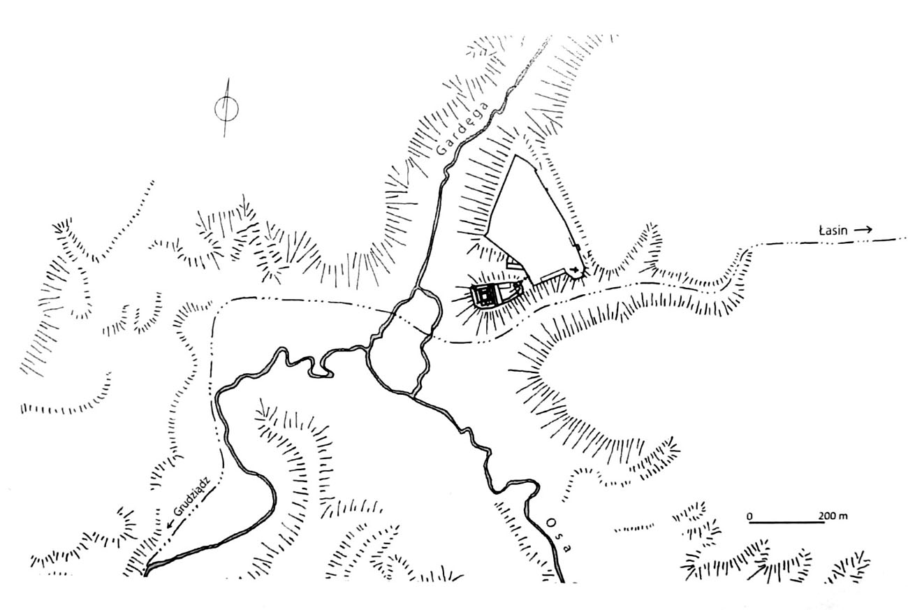
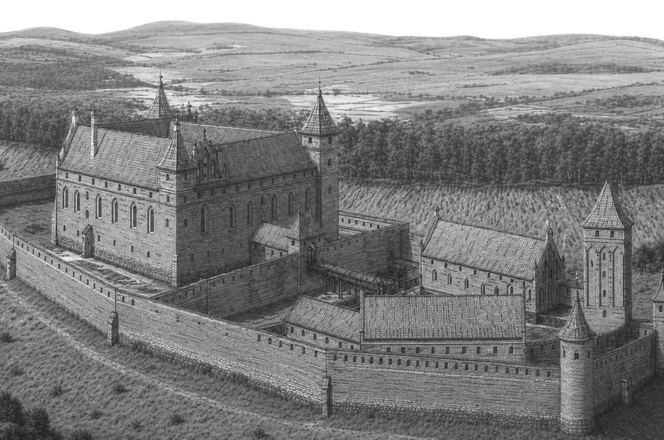
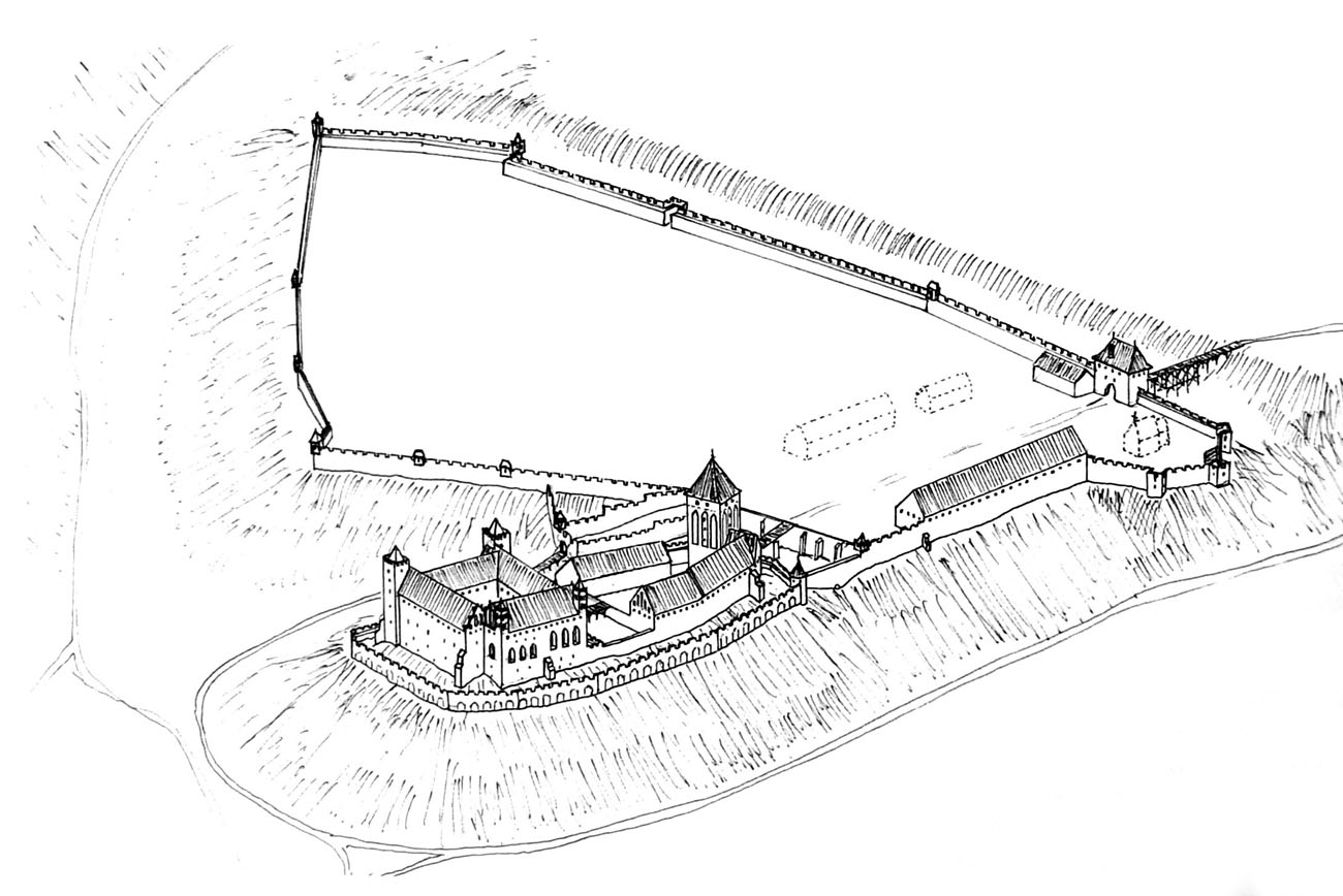
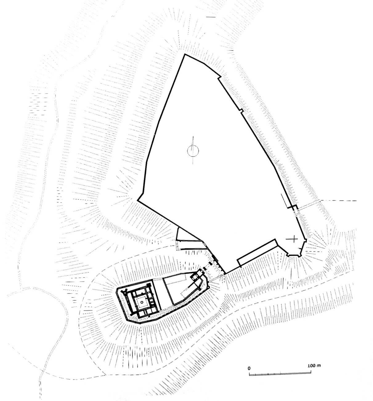
The castle was built on a high hill, at the mouth of the Gardęga River and the Osa River. It was distinguished by its exposed location on the eastern bank of the valley, along which the road from Grudziądz to Nowe Miasto Lubawskie ran. It consisted of three parts. The top of the hill, towering about 45 meters above the valley level, was occupied by the upper ward in the form of a quadrangle of buildings, protected on three sides by high slopes and river beds. From the east, it was preceded by a trapezoidal middle ward (inner bailey), narrowing towards the east. The third element was the extensive outer bailey, located on the adjacent hill on the eastern and north-eastern sides.
The upper ward consisted of four wings surrounded by the outer perimeter of walls, which also surrounded the eastern part of the hill with the middle ward. The upper ward was protected on three sides by natural slopes, and from the east by an artificial ditch with a bridge. The south-west corner of the zwinger wall was cut due to the shape of the terrain. The four-wing house of the commandry had dimensions of 38 x 45.5 meters, but its wings did not form a compact quadrilateral because they did not meet in the south-west corner. It is possible that the main tower was supposed to be erected there, but it was never built due to the instability of the ground. The two northern corners of the castle were reinforced from the outside by two slender, protruding, four-sided towers (similar to those used in the castle in Radzyń Chełmiński), the north-west of which was equipped with buttresses. The range closing the courtyard from the south was also flanked by two small corner towers, but it did not have foundations, so it can be assumed that were superimposed on the wing walls (similar to the castle in Golub). It is also known that the upper ward had a dansker, perhaps located near the western wing.
The interiors of the upper ward probably followed the pattern of other commandry Teutonic castles, so it had a ground floor for economic functions, a first floor intended for representative and residential rooms, as well as attics used for defense and as granaries. On the first floor of the southern wing there was a chapter house (or refectory) and a chapel, located in such a way that its chancel was oriented towards the cardinal sides of the world. In the eastern wing, there may have been another refectory on the first floor, although this function could also have been served by a large hall on the first floor of the western wing, connected to the dansker by a porch. On the ground floor, the eastern wing had an entrance gate on the axis. In the northern wing there could be a brewery and a kitchen, while in the western one there could be a bakery (this layout existed in the 16th century). All wings except the northern one had basements. The courtyard was surrounded by wooden cloisters, and in its center there was a roofed well. The eastern wing had an entrance gate on the axis.
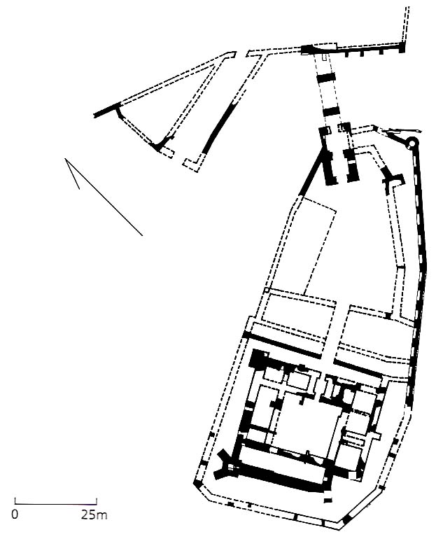

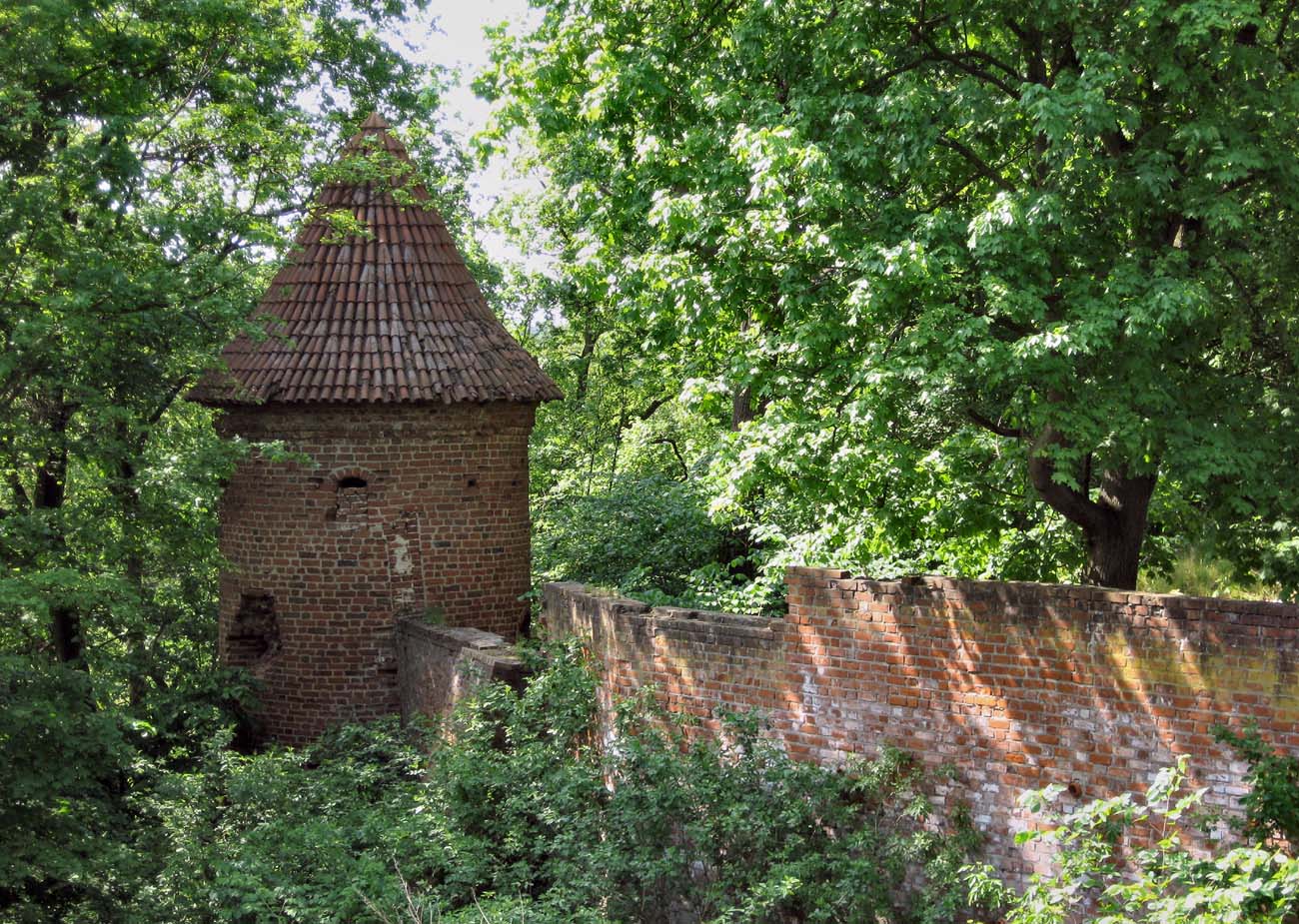
The middle ward (or the inner bailey) had an irregular, trapezoidal shape, covered with brick buildings only in the 15th century. It is known that there was a “summer house” there, and between it and the gate tower the houses of the commander and the Grand Master. There may also have been economic buildings in the northern part of the middle ward. All buildings were attached to the northern and southern curtains, leaving a long, irregular courtyard in the center. The middle ward was surrounded from the south and east by an external defensive wall, which was an extension of the zwinger wall of the upper ward. In the south-eastern corner it was strengthened by a small, cylindrical tower with a diameter of 4.8 meters. Its interior was divided by ceilings into three floors, slightly widened in the upper part (lower cell, middle entrance room, upper room with three loop holes).
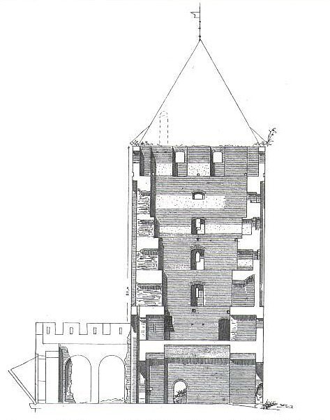
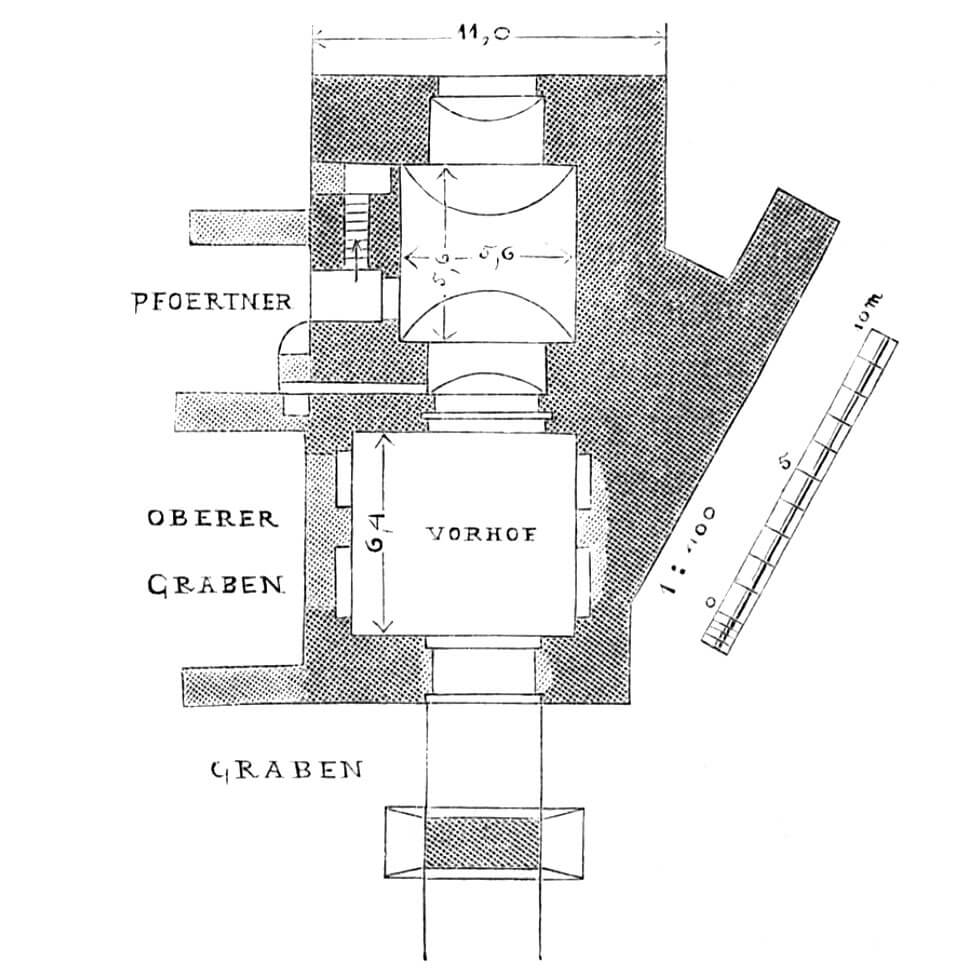
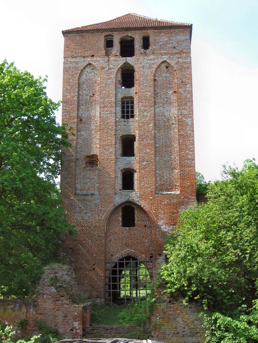
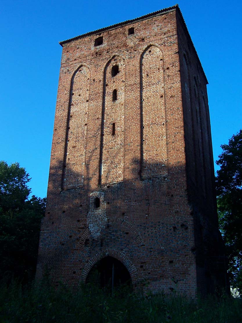
Between the middle ward and the lower ward (or the outer bailey), there was a gate tower on a square plan with sides 11 meters long. It was preceded by a 9-meter-long and 3.5-meter-wide neck of the foregate, topped with battlemented wall-walk in the crown, and closed at the front by a drawbridge. The bascule and permanent part of the 25-meter-long bridge rested on two brick pillars about 8 meters high. According to the surveys, the moat was to be closed on both sides with transverse walls to prevent enemies from penetrating it. The eastern façade of the gate tower was divided by a high, pointed arcade, inside which a portcullis was raised in guides. Above, the tower was decorated with three long, pointed blendes, the central one of which was pierced with windows. The remaining facades of the tower were also shaped similarly. Its interior was divided into seven floors, of which the lowest gate passage was covered with a barrel vault, and the higher ones were separated by timber ceilings. Communication between them was provided by wooden stairs or ladders, a brick staircase led only to the first floor.
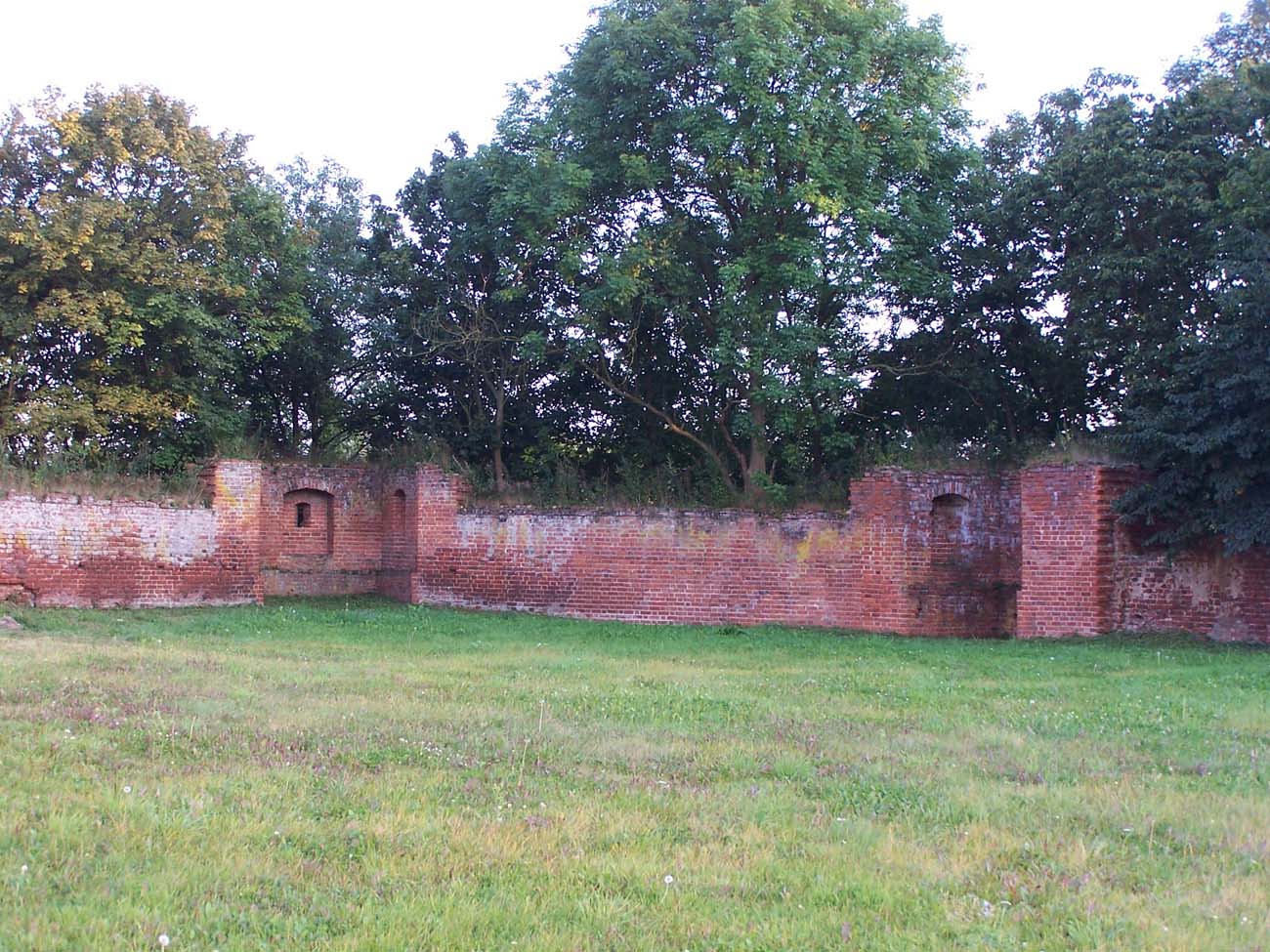
The economic area of the extensive outer bailey, with an area of as much as 4.5 ha, was similar in shape to a trapezoid with a semicircular bulge in the south-eastern corner. It was surrounded by a defensive wall with 17 towers. Some of them were low half-towers, opened to the courtyard, while others probably had the character of bartizans hung on the walls. There were two entrances to the outer bailey: from the west through the gate tower from the middle ward and from the east through a wide, three-story gatehouse with a furnace next to the entrance. The fortifications of the outer bailey were complemented by a moat on the eastern side, approximately 20 meters wide and 8 meters deep).
Current state
To this day, a long fragment of the outer wall with a corner, round turret has survived at the middle ward. To the north of it stands a monumental gate tower with foregate walls, partially preserved to a height of 3 meters. Around the outer bailey significant sections of walls, the remains of four half-towers and relics of probably Gothic economic buildings have survived. Only poorly visible fragments of the walls have survived on the upper ward (in the northern part with a pointed arch passage, on the inside with a niche with a segmental arch). Currently, the area of the castle is private property, but it is possible to visit the monument.
bibliography:
Die Bau- und Kunstdenkmäler der Provinz Westpreußen, der Kreis Graudenz, red. J.Heise, Danzig 1894.
Leksykon zamków w Polsce, red. L.Kajzer, Warszawa 2003.
Stocka M., Zamek pokrzyżacki w miejscowości Rogóźno-Zamek, “Ochrona Zabytków”, 1/2006.
Torbus T., Zamki konwentualne państwa krzyżackiego w Prusach, część II, katalog, Gdańsk 2023.
Wasik B., Budownictwo zamkowe na ziemi chełmińskiej od XIII do XV wieku, Toruń 2016.