
History
Przeworsk, a Slavic stronghold from the 9th/10th century, appeared in documents in 1280, when Prince Leszek the Black led a retaliatory expedition to the borderland of Ruthenia, during which, among other things, he burned a place called “Pereworsk”. Its great role resulted from its location on an important trade and communication route connecting the lands of Ruthenia with Poland. It was included in the borders of the latter after the capture of Red Ruthenia by Casimir the Great after 1340. In 1393, as a result of the actions of Jan of Tarnów, Przeworsk obtained a town charter from King Władysław Jagiełło, extended with another privilege a year later. Presumably, along with the new organization of the town, wood and earth fortifications were marked out.
The construction of defensive walls in Przeworsk began late, at the turn of the 15th and 16th centuries. This was probably influenced by the Tatar and Wallachian raids of Przeworsk and its vicinity, intensifying from the end of the 15th century. Attacks took place in 1488, 1489 and 1490, and then after the defeat of Jan Olbracht in Bukovina in 1498, when Tatar raids seriously devastated the surrounding lands. In 1508, the king freed Przeworsk from paying the tax to the state treasury, and ordered the proceeds from it to be used to repair and expand the walls and other fortifications of the town. Also, Pope Clement VII supported the initiative to increase the defenses of the ravaged Przemyśl diocese. In 1512, he issued a bull for the Bernardines of Przeworsk, under which the monks could grant indulgences to those who helped in the construction of the defensive wall at the friary. The bull also allowed the order to collect funds for the purchase of cannons and gunpowder, and also absolved the monks who defended the town and the monastery.
Work on the expansion of the Przeworsk fortifications lasted in the second quarter of the 16th century. At the Sejm of 1527 and 1529, King Sigismund I, at the request of the owner of the town, Jan of Tarnów, granted him a privilege that reduced the sum of the szos tax paid by the town’s population, while the reduced amount was to be spent on expenses related to the construction of the walls, as well as preparations for their upgrades or repairs. In 1550, King Sigismund Augustus released the townspeople from all customs duties in the Crown and in Lithuania. In addition, he authorized the town to collect bridge tolls on Wisłok and Mleczka in order to improve fortifications, roads and crossings.
In the 17th century, the fortifications of Przeworsk were often the target of attacks. In 1612, the town was burned by the Tatars, and in 1624 it was destroyed by the troops of Kantymir Murza, although the people of Przeworsk were to take part in victorious battle with the Tatars in Nowosielce, where, under the leadership of the village headman Pysz, they destroyed the enemy and recaptured the prisoners. In 1648, Przeworsk had to pay a ransom to the Cossacks, in 1657 Karol Gustav’s troops stood near the town, and a year later Rakoczi’s army passed the town. Subsequent Tatar invasions destroyed Przeworsk in 1672 and 1677, while at the beginning of the 18th century, outdated fortifications did not stop the Swedish and Russian armies.
In 1693, on the order of the tenant of Przeworsk, an inspection of the condition of the fortifications was carried out, which was described as devastated, dilapidated, and destroyed in many places. Applications were made for their repairs, commissioned in individual sections to the guilds of furriers, linen makers, tailors, shoemakers, cloth makers, the Jewish community and the town council. The first planned demolition of the town wall was carried out in the 19th century. Further damages were caused by the Germans during World War II.
Architecture
The town was founded on the eastern side of the Mleczka River, on the longitudinal ridge of a hill 203 meters above sea level. The slopes down relatively gently towards the river, but the land at their foothills to the south and west was wet and swampy. From the north-east, large forest complexes were adjacent to the town, and from the rest, the foreground of the Przeworsk did not have major natural obstacles.
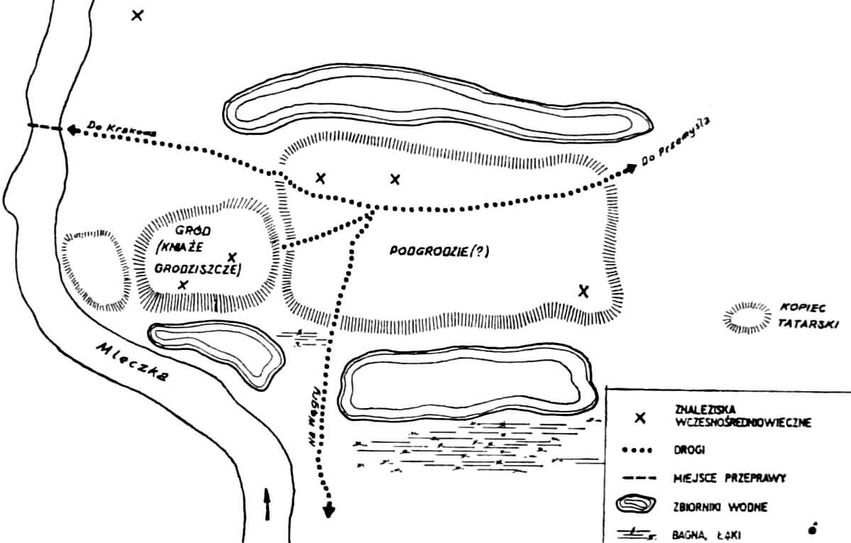
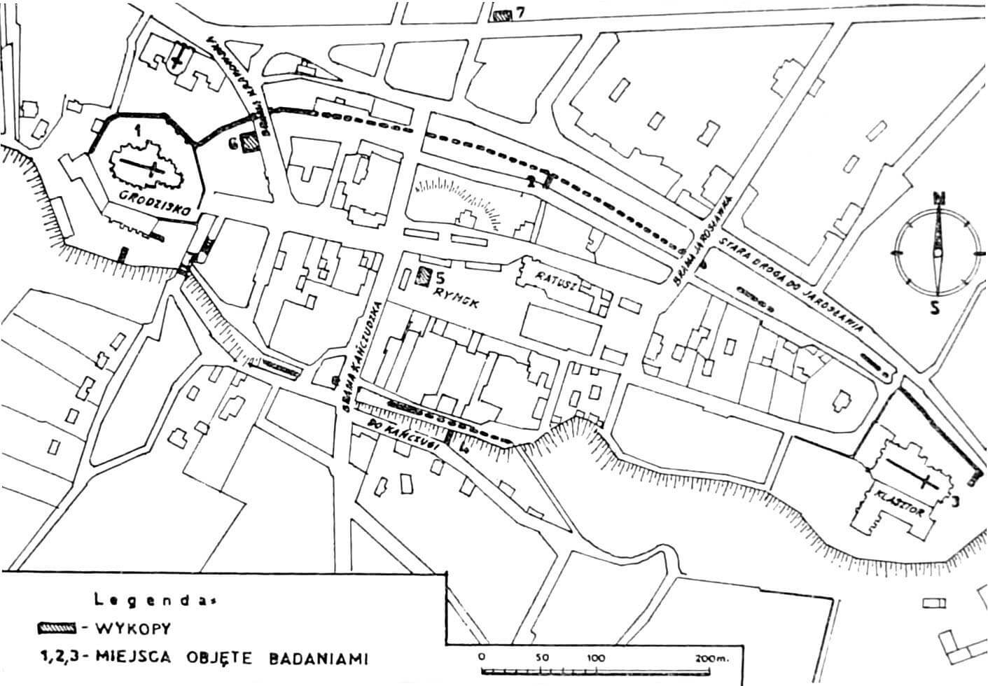
The extreme western part of the town hill was originally occupied by an early medieval stronghold (the so-called Kniazie Grodziszcze), in which at the end of the 14th century a parish church with a monastery of the Holy Sepulcher was founded, tightly surrounded by town fortifications. The opposite, eastern part of the fortifications was occupied since the second half of the 15th century by a Bernardine friary, while in the middle, in the area of the former outer bailey, there was a market square with a town hall, from the corners of which main roads led towards gates and sacral buildings.
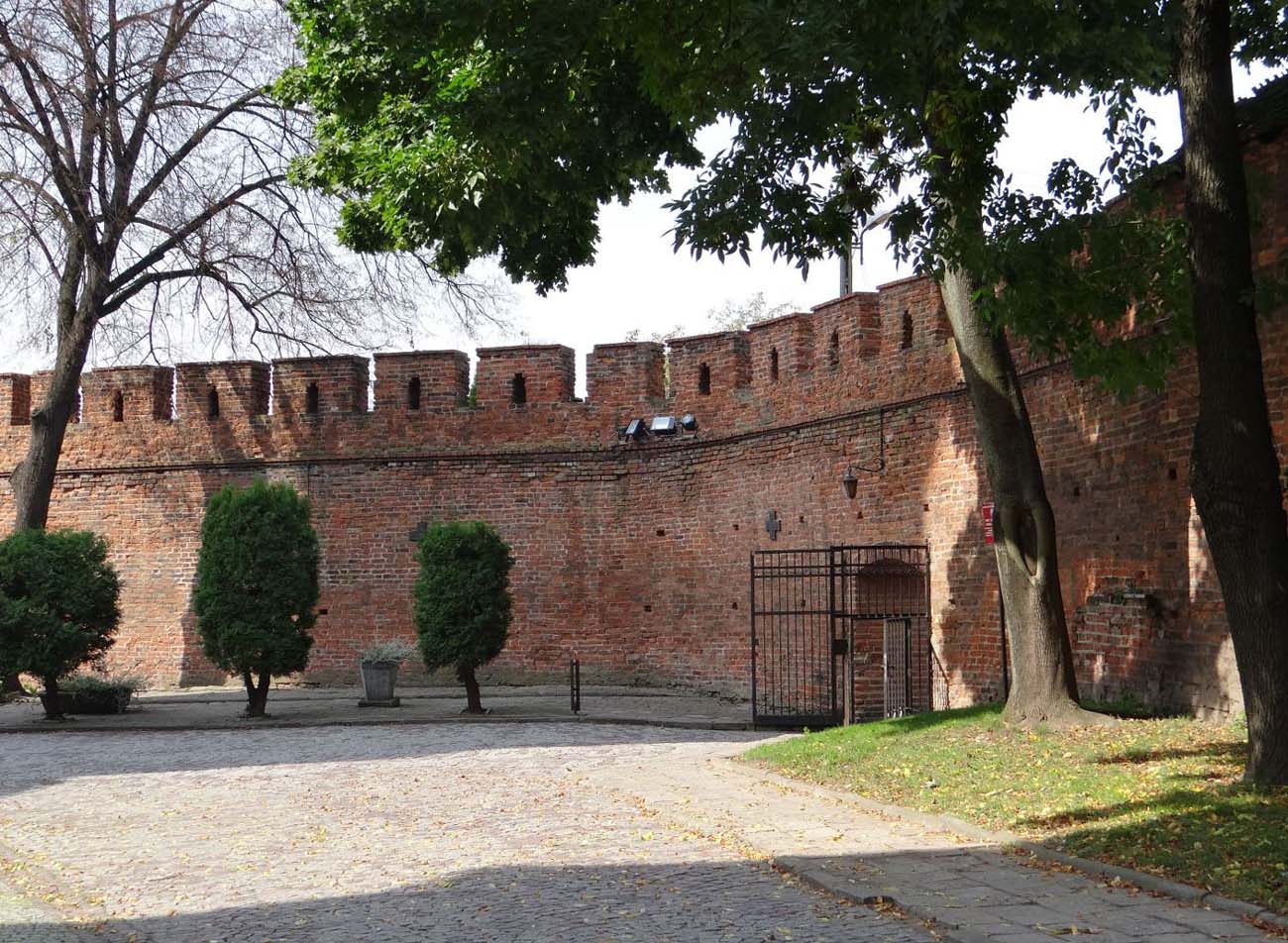
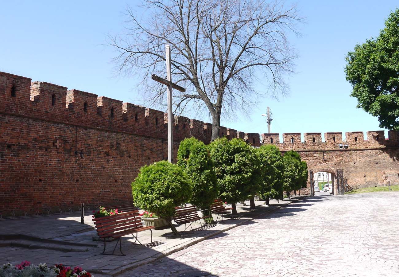
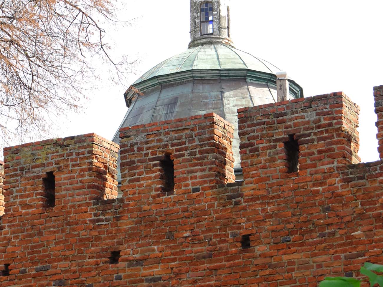
The oldest sections of the defensive wall were erected at the parish church and at the Bernardine friary, which were probably independent places of defense in which the town’s population took refuge. The height of the defensive walls reached about 5 meters, where at the level of the offset there was a wall-walk. The walls were crowned with a crenellation in which densely spaced merlons were placed with stepped headed arrowslits. The perimeter of the walls was to be strengthened by five towers. Three gates led to the town: Łańcut Gate from the north-west, Jarosławska Gate from the east and Kańczudzka (Hungarian) Gate from the south.
Current state
The currently existing sections of the defensive walls are visible in the basilica of the Holy Spirit and the monastery church of St. Barbara. In addition, smaller fragments can be found on the following streets: Kazimierzowska (together with a pointed opening being a postern or entrance to the tower), Tkacka, Słowackiego, św. Jana and at the back of the houses at ul. Kilińskiego. On the longest fragment, from the monastery buildings of the Holy Sepulcher by the basilica to the old gate, a parapet of the wall with crenellation and arrowslits has been preserved, under which a wall-walk ran. Further on, up to the belfry erected in the place of the tower, the walls are devoid of crenellation and secondarily supported from the inside with three buttresses. The walls at the Bernardine friary are also well preserved, reaching a height of 3.5-5 meters, supported by an early modern buttress on the west side.
bibliography:
Siedem wieków Przeworska. Studia i materiały z dziejów miasta, red. A.Kunysz, Rzeszów 1974.