
History
The castle in Pokrzywno (German Engelsburg) was one of the oldest Teutonic Knights strongholds in the Chełmno Land, built on the site of a settlement and a Slavic hillfort from the turn of the 12th and 13th centuries (“castrum Copriven”). The castle hill towered over the route leading from Radzyń to Grudziądz, so it was located in a place of strategic importance. The Teutonic Knights began building a wooden watchtower after taking over the surrounding areas in 1231. In 1279, information was recorded about the first commander, Henry Brabantius, which was probably related to the construction of a brick castle. According to later information, its chapel dedicated to St. Lawrence was supposed to be consecrated in 1339.
In 1410, after the Teutonic defeat at Grunwald, the castle in Pokrzywno was captured by the knights of the Chełmno Land. The Polish king gave “Castrum Koprziwno alias Engelsbergk” to the knight Dobiesław of Oleśnica, but the Teutonic forces recaptured the castle in the same year. It was to be garrisoned with mercenary troops until the end of the war. Perhaps the building suffered some damages during the fights, because in 1413, on the initiative of Grand Master Heinrich von Plauen, the Teutonic Knights began repairs and modernization of the castle’s defense system. The buildings were renovated, the walls were raised and equipped with more modern loop holes. At least 14,000 bricks were used for construction works until 1416. After the coup, Heinrich von Plauen himself was demoted and transferred to the commandry in Pokrzywno, where he stayed in 1413-1414. Despite the construction works, Pokrzywno served as a commandery only until 1416, i.e. until the death of the last commander, Friedrich von Zollern. After that date, the castle and the nearby farm were incorporated into the Rogóźno.
The castle remained the property of the Order until the outbreak of the Thirteen Years’ War in 1454, when it was captured without a fight by rebellious troops of the Prussian Confederation. Pursuant to the agreements of the Second Peace of Toruń, in 1466, Pokrzywno together with the entire Chełmno Land was annexed by Poland and until the first partition in 1772 it was the seat of Polish starosts. The castle burned down in 1611, and in 1657 it was devastated by the Swedes. Despite partial reconstruction on the initiative of Jan Dominik Działyński, it did not regain its original military values, although its chapel was described as spacious and beautiful during the survey from 1664. At the end of the 18th century, the buildings were sold to a private person and began to be dismantled in order to obtain building materials.

Architecture
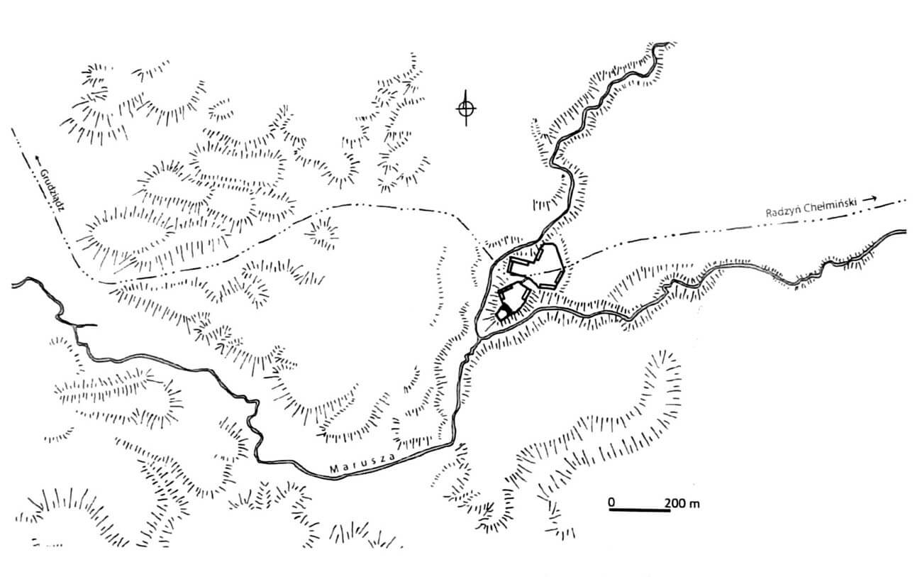
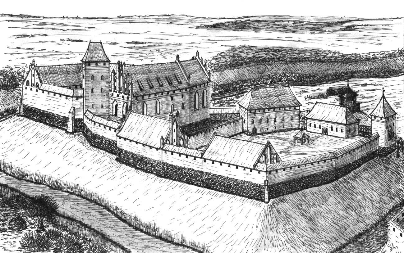
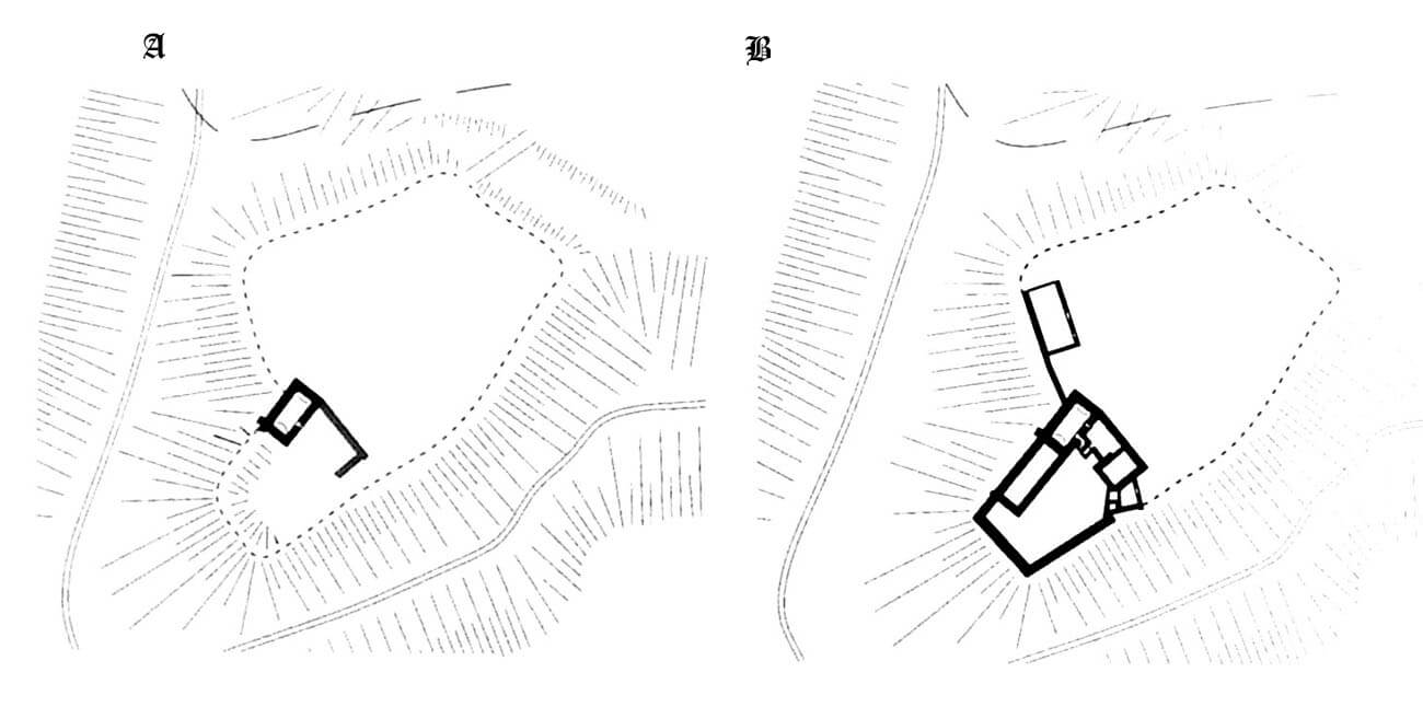
The castle was built on the head of a hill at the fork of two streams. The natural topography of the area protected it on three sides, with an access road from the east only. The streams were used to dam water and form ponds, where a mill probably operated in the north. In the late Middle Ages, the fully formed complex consisted of the oldest upper ward, occupying the edge of the promontory, the first bailey (middle ward) on the north-eastern side and a spacious, youngest, second bailey (lower ward), separated by a moat, occupying a vast area further north-east. The main part of the castle from the middle ward was not separated by a ditch, and the road leading to it was paved.
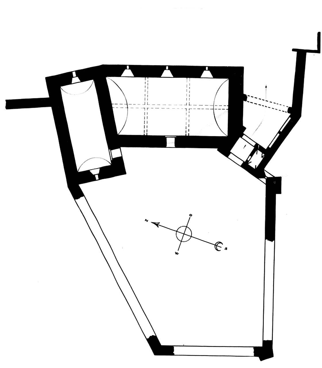
The upper ward consisted of two L-shaped wings, built in several phases until the end of the 13th century. The remaining residential buildings in the courtyard of the upper ward could only be of a lighter wooden structure. Presumably, the castle did not have a main tower. As the oldest northern building was later extended to the south-west, and a second wing was added from the east, some of the windows had to be bricked up in the older part and the entrance to the basement transformed by adding a neck with stairs. The basements had vaults, but the above-ground rooms were initially covered only with flat wooden ceilings supported by granite corbels. In the first half of the 14th century, the flat ceilings in the upstairs chambers were replaced with a cross-rib vault. In the northern part of the upper ward there was probably a castle church, and in the remaining rooms there were other representative rooms, e.g. a refectory. Like other Teutonic castles, there had to be a kitchen and a bakery on the ground floor. Communication between the rooms was most likely provided by a cloister, but it is not known whether it was made of bricks or wood.
From the south-east of the residential building was a small gatehouse with a trapezoidal foregate, the size of which and thin walls would indicate its insignificant height. The gate passage on the ground floor, measuring 3.7 x 3.2 meters, opened on two sides with pointed arcades, and on the side it was connected to the guards’ or porter’s room, measuring 2.2 x 3.5 meters. This room could be closed with a bar placed in a hole in the wall. On the first floor of the gatehouse there was a two-bay room with dimensions of 5.4 x 2.6 meters, without a fireplace, so it did not serve a residential function. It was covered with a cross-rib vault with ribs of a rectangular cross-section, based on wall columns with moulded bases and cup-shaped capitals. From the east, the room was illuminated by two windows with trefoil heads and wide internal splayeds. A castle chapel could have been located there, as evidenced by architectural details. Above there was another, slightly smaller room.
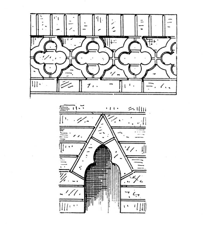
The middle ward consisted of several buildings adjacent to straight, but repeatedly bent sections of the perimeter walls, reinforced with only one corner turret on the western side. In the northern part of the courtyard there was a three-story building, about 37 meters long, called the granary, although in fact it was a brewery or malt house. Its decorative elements (a brick frieze with a quatrefoil motif) would indicate that after the economic buildings were moved to the lower ward in the 14th century, it also served residential functions. In addition, there were other economic buildings on the internal facades of the perimeter walls, including stables in the eastern part.
The entrance to the middle ward was located close to the northern corner and was located in the gatehouse protruding in front of the curtains. A ditch was dug in front of the gate between the two outer baileys. On its other side, when building the entrance gate to the bridge, decorations made of zendrówka bricks were used. The passage was equipped with a pointed opening, above which there was a stepped gable topped with decorative triangular wimpergs and six pinnacles. Perhaps next to this ornate but devoid of military value gate there was a small gatekeeper’s building.
The outer ward or lower ward, occupied a large, irregular area on a polygonal plan. Inside the perimeter of the walls, there were farm buildings, including a barn on the western side, decorated with rhombus patterns made of zendrówka brick. Further buildings were also located in the south-eastern part, where stables, sheepfolds and other storage and utility buildings could be located. An unusual feature of the lower ward was its passage-like character, because there was a road running along its entire length from east to west.
Current state
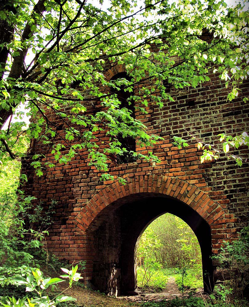
Currently, the best-preserved element of Engelsburg is the gate of the upper ward with the vault on the first floor, which has partially collapsed in recent years, the granary in the middle ward, and the gate and barn in the outer bailey, i.e. in the lower ward. Additionally, fragments of the walls of the northern and eastern wings of the main building, defensive walls and the walls of the foregate visible up to a height of about 3 meters have survived. The neglected and crumbling ruin is in private hands, constituting a shameful example of the degradation of a valuable monument since the mid-1990s (the so-called granary was still roofed in 2000, but today it is a complete ruin).
bibliography:
Die Bau- und Kunstdenkmäler der Provinz Westpreußen, der Kreis Graudenz, red. J.Heise, Danzig 1894.
Leksykon zamków w Polsce, red. L.Kajzer, Warszawa 2003.
Sypek A., Sypek R., Zamki i obiekty warowne od Malborka do Torunia, Warszawa 2004.
Torbus T., Zamki konwentualne państwa krzyżackiego w Prusach, Gdańsk 2014.
Torbus T., Zamki konwentualne państwa krzyżackiego w Prusach, część II, katalog, Gdańsk 2023.
Wasik B., Budownictwo zamkowe na ziemi chełmińskiej od XIII do XV wieku, Toruń 2016.