
History
Tum Hill in Płock, due to its defensive shape and convenient location at the intersection of trade routes, was settled from the second half of the 10th century, with the stronghold and its surrounding settlements being built as part of a planned operation in an area previously untouched by medieval settlement. The hillfort was recorded in the forged medieval document, in the section relating to 1065. Płock was mentioned twice as a castrum on a list of strongholds, and in the context of granting the church of St. Lawrence “in Plocch” to the abbey in Mogiła.
During the reign of princes Władysław Herman and Bolesław III Wrymouth, the stronghold of Płock was an important political and ecclesiastical center, surrounded by wood and earth ramparts and having a craft outer bailey. At the end of the 11th century, a large-scale reconstruction of the stronghold’s ramparts was carried out, widened and made structurally more uniform. Within the new ramparts, Romanesque stone buildings were erected, including the cathedral of Władysław Herman. This was replaced in the second quarter of the 12th century by a new cathedral, built at the initiative of Bishop Alexander of Malonne. An anonymous chronicler known as Gaul recorded that in 1100, Bolesław III Wrymouth received his knighthood in Płock, and in 1102, Władysław Herman’s funeral took place in Płock Cathedral. Both records indicated Płock’s role as the capital of the Masovian region, at that time serving as the ruler’s favorite seat and the seat of the bishopric. After Władysław Herman’s death, the stronghold became primarily the seat of the bishop for less than a century.
The Płock stronghold was destroyed and rebuilt several times. The burning of Płock by Pomeranians was recorded in the Life of St. Otto around 1126, when the graves of Bolesław III Wrymouth’s parents were desecrated. Subsequent raids on Płock were carried out by the Prussians in 1217, the Pomeranians in 1226-1227, and Henry, Margrave of Meissen, in 1235. One of the last and greatest destructions were associated with the Lithuanian invasion of 1262. During the absence of the ruler of Masovia, Siemowit I, who had left for Jazdów, one of the Lithuanian units, thanks to surprise and a significant numerical advantage, captured and devastated Płock. After the invaders withdrew, Bolesław the Pious rebuilt the fortifications from the ruins, and then returned the stronghold to Princess Perejesława, the widow of Siemowit I, who was killed during the invasion, and his minor sons, Konrad and Bolesław.
The shaping of the castle of the Mazovian princes began at the end of the 13th century. Probably around 1290 Bolesław II, after taking over the Płock district, built a defensive tower-donjon in the castle. At that time, the fortifications had to be so strong that the Czech armed expedition of 1299, caused by Bolesław II’s sending of Kunegunda to Prague, Wacław II’s sister, did not conquer the castle. The castle walls were bricked up either at the end of the 13th century or in the first half of the 14th century, during the successor of Bolesław II in the Płock principality, Wacław (Wańko). However, Wacław had fewer investment opportunities than his father, and his principality was drawn into the political games of stronger neighbors: Poland, the Teutonic Order and Lithuania. Due to the political rapprochement of Wacław to the Teutonic Order, in 1327 the city, and perhaps also the castle, were occupied by the army of king Władysław Łokietek. In 1329, the army of John Luxemburg of Bohemia approached Płock. Wacław surrendered after a few days of siege, and was forced to pay homage to the Czech king.
In 1351, due to the death without an heir of the next prince of Płock, Bolesław III, the duchy he held was divided. Based on prior agreements, Płock then passed to the Polish King Kazimierz the Great, who pledged to free the Płock, Wizna and Zakroczym lands from the suzerainty of the Czech king. Appreciating the strategic location of Płock Castle and considering the threat from Lithuania, the ruler financed the construction of the town’s defensive walls and a second ring of castle brick fortifications in the second half of the 14th century, making Płock one of the most heavily fortified centers in Masovia.
After the death of Kazimierz the Great in 1370 and the extinction of the royal line of the Piast dynasty, the Duchy of Płock returned to the Masovian princes (Kazimierz the Great had already promised Siemowit III in 1355, when granting him a fief after the deceased Kazimierz I of Warsaw, that after the death of the Polish king, he would receive the “castrum Ploczsk cum tota terra”). The Masovian princes resided in the castle until 1495, when Masovia was finally incorporated into Poland. At that time, King John Albert inherited the region from Prince Janusz II, who had died childless. As a result, the castle complex ceased to serve as the principal ducal residence, although it continued to serve as an important religious center due to the presence of the cathedral and clergy houses, and a royal seat for a time.
In the 16th century, the castle was rebuilt, among others due to the collapse of its southern part due to the slipping of the Vistula embankment in 1532. At that time, the building of the Gothic palatium was damaged and a fragment of the perimeter walls was destroyed. In the following years, the castle played a role as the administrative center of the province and a comfortable residence of starosts. As a result, a process of slow loss of its defensive functions began, typical of many royal castles in the early modern period. In 1538, the north-west part of the castle passed into the hands of the Benedictines, who remained there until 1781, building the Baroque abbey in the 17th century. In 1538, the king also gave Bishop Piotr Gamrat and the chapter the square “inter moenia castri Plocensis” for the purpose of building a vicar’s house, while maintaining access to the castle wall.
During the Swedish Deluge, Płock fell into decline. It was occupied by the Swedish army in 1655, charged with contributions, and the commanding officer in the city, Colonel Assemberg, plundered the parish church, the Holy Trinity church and the cathedral. The castle and city were devastated even later during army marches crossing the Vistula nearby. The fall of the castle was sealed by the events of the Great Northern War. The Swedes, who occupied Płock in 1704, again devastated the city and plundered the cathedral, and the effects of the Russian attack of 1705, when the Swedish garrison tried to defend itself within the walls of the former castle, were even worse. After the partitions of Poland, most of the walls were pulled down by the Prussians.
Architecture
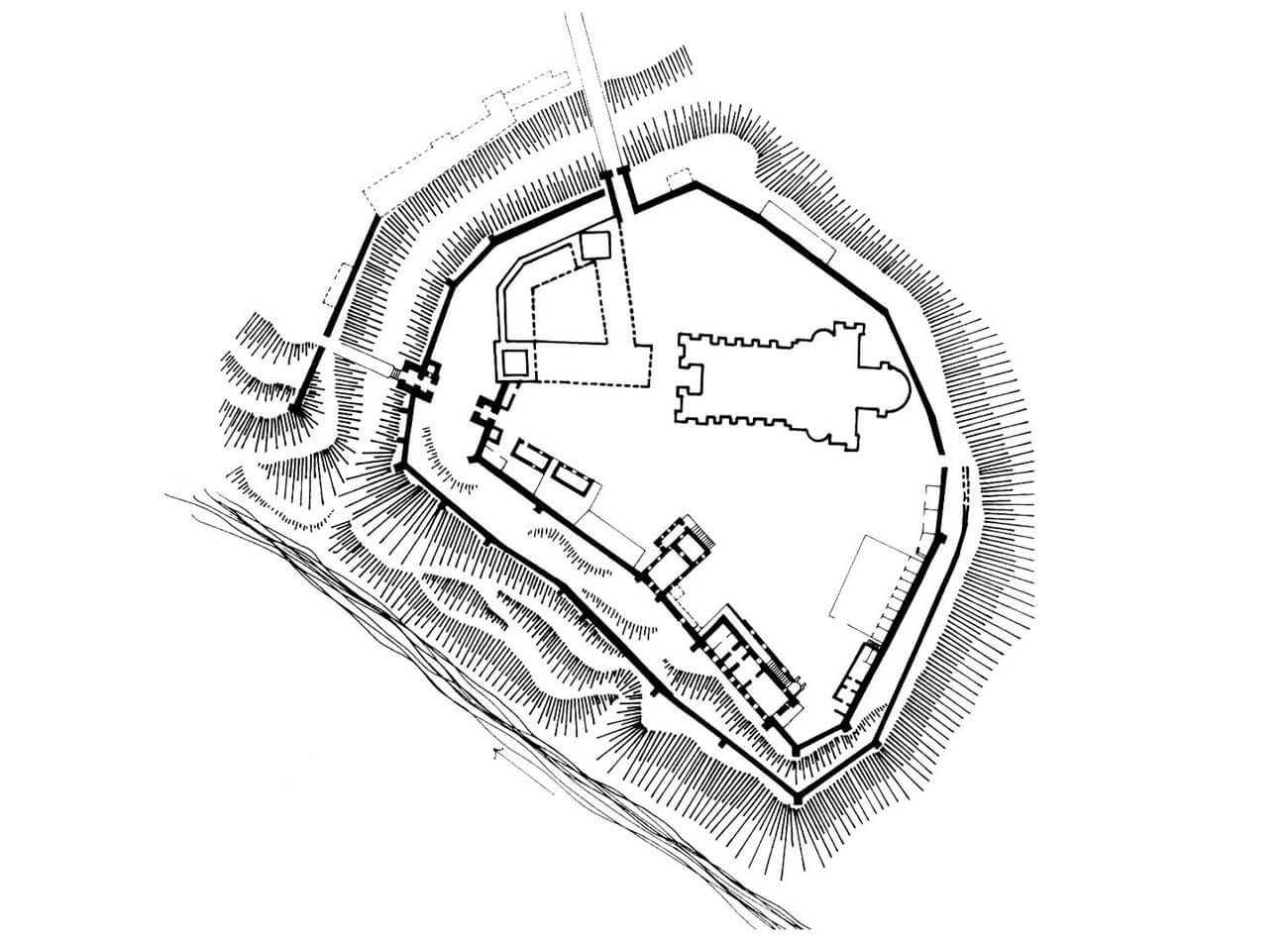
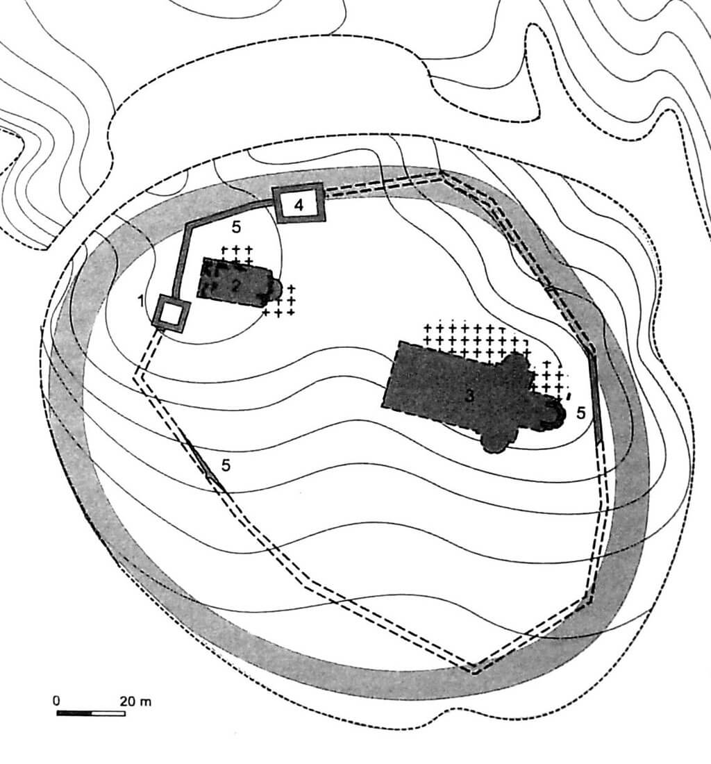
The stronghold, and later the castle in Płock, were built on a promontory of a moraine plateau known as Tum Hill, towering over the Vistula River with high, steep escarpments. This hill provided protection on three sides, while on the fourth, northwest side, the promontory was cut off from the plateau by a transverse ditch. A bridge over the moat led to the outer bailey, which was transformed into a chartered town in the 13th century, significantly enlarged to the northwest, and fortified with walls in the second half of the 14th century. To the northeast and east, the stronghold was separated by the slopes of a ravine from the settlement with a Dominican friary, which in the 14th century was located outside the town’s defensive perimeter. In the Middle Ages, the promontory was not flat, characterized by a slight slope towards its southern edge.
During the early Middle Ages, Płock was a unified stronghold, encompassing the entire hilltop area with a single ring of ramparts, approximately 6-8 meters wide at the base. The stronghold covered a maximum of approximately 2 hectares. The ramparts were a complex structure, rebuilt several times and reconstructed after fires. Work began with the laying of a layer of planks, laid rather loosely, sometimes with significant gaps. From the inside of the stronghold, it were bounded by a stone bench, 0.6-0.8 meters wide, made of granite boulders covered with sand. The rear walls of the wooden boxes, which formed the core of the rampart, were supported on these benches. The boxes were square in plan, with sides no greater than 2 meters. It were not closely spaced, but the gap between them was filled with a layer of brown clay. The rampart was preceded by a sandwich-shaped offset, made of semicircular logs laid perpendicular to the rampart’s course and covered with layers of clay. A similar structure could also be placed on the inner side of the rampart. In some sections, the rampart was also stabilized from the inside with vertically driven posts.
Around the second half of the 11th century, the rampart was rebuilt. The older fortifications were partially leveled and transformed into a massive earthwork, forming the foundation for a new rampart, with a box-shaped core and two offsets constructed using the sandwich technique. The grid beams of the new sandwich were laid slightly diagonally, sloping towards the interior of the stronghold. The crown of the rampart must have been, as in the first phase, a circumferential wall-walk, likely protected by some form of parapet. After the reconstruction, the base of the rampart could have been over 10 meters wide. Repairs and reconstructions of the rampart, carried out in the 12th and 13th centuries, consisted of slightly widening its earthen base and placing a box-shaped structure filled with clay on it, thus ensuring that the appearance of the ramparts remained unchanged.
The basic type of residential structure in the stronghold were densely spaced, rectangular, ground-level log houses with shallow, usually located in the corners cellars. The area immediately adjacent to the ramparts, forming a circular street along the fortifications, remained largely undeveloped. This area, as well as other streets and squares within the stronghold, were lined with timber to prevent mud from clogging the communication routes. At the end of the 11th century, a reorganization of the stronghold’s interior led to a sparsification of residential dwellings and a significant reduction in the number of economic buildings, likely relocated to the outer bailey. Most likely, before the mid-12th century, the stronghold’s interior acquired a new appearance, whose primary elements were several stone structures and accompanying clusters of wooden buildings. In the 12th and 13th centuries, several larger buildings appeared within the stronghold, constructed using a different technique, using vertical posts to stabilize the walls or support the roof trusses. It must have been associated with the princely residence, perhaps situated in the most protected southern part of the courtyard, or with the bishop’s curia, which may have been located in the northern part of the stronghold.
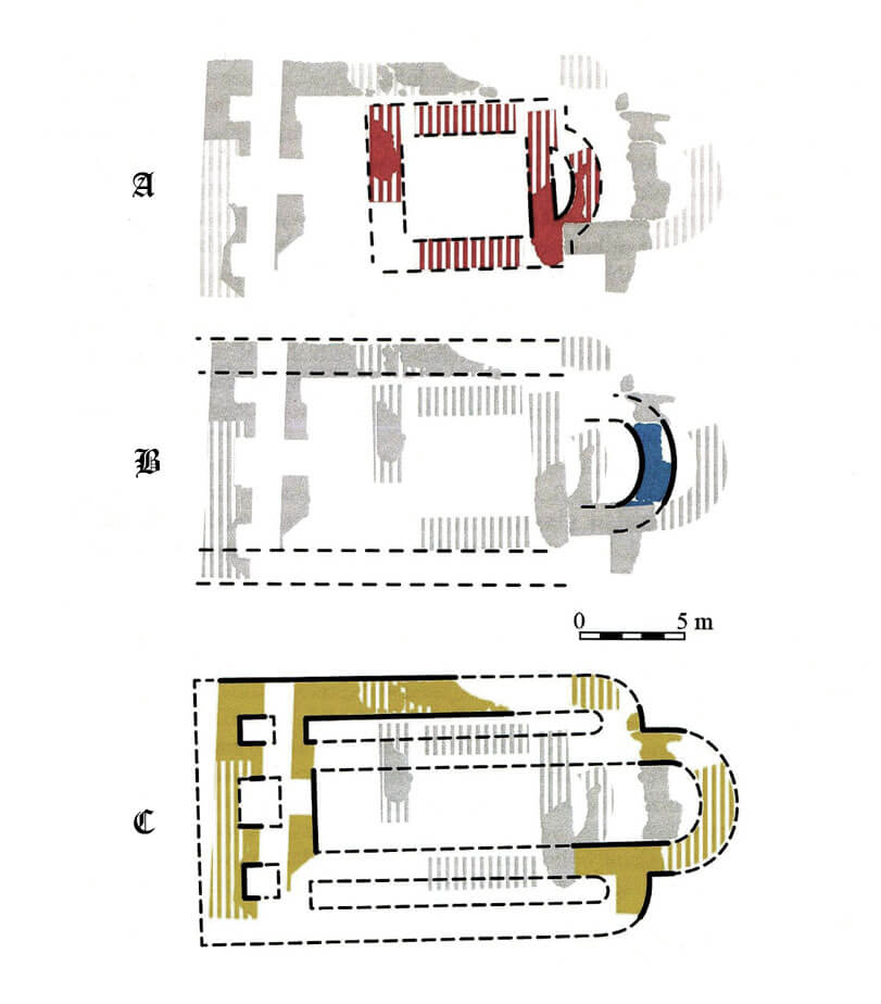
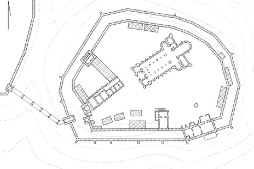
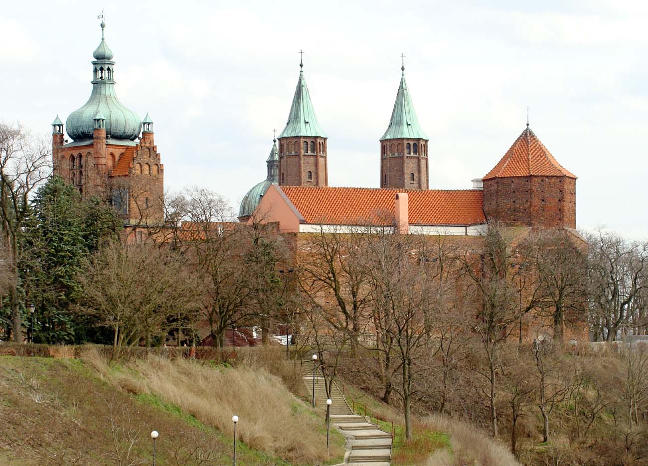
Since the 11th century, the eastern part of the stronghold’s courtyard was occupied by a Romanesque cathedral. After its 12th-century reconstruction, it had the form of an aisled, probably two-choir basilica with a two-towered façade, a transept with apses, and a chancel terminated on the eastern side by a third apse. A cemetery adjoined it to the north and south. Additionally, in front of the western façade of the cathedral, from the end of the 11th century, there was a small stone building, either secular or sacral, which was replaced around the mid-12th century by a freestanding rotunda with a nave with an internal diameter of approximately 7 meters and an apse 1.5 meters deep. The western part of the rotunda contained a gallery, supported by a central quadrangular pillar. On the northwest side, near the castle gate, there were further stone religious buildings. Initially, in the 11th century, it may have been a small aisleless church with a shallow semicircular apse. It was enlarged around the 12th century, retaining the same spatial layout, and replaced at the turn of the 12th and 13th centuries by a small but aisled basilica with a square chancel enclosed by an apse on the eastern side and flanked by two apsidioles. The western section of the basilica may have consisted of a straight wall or two quadrangular towers. If it was associated with a Benedictines, the buildings of the monastery’s oldest claustrum must have been located nearby.
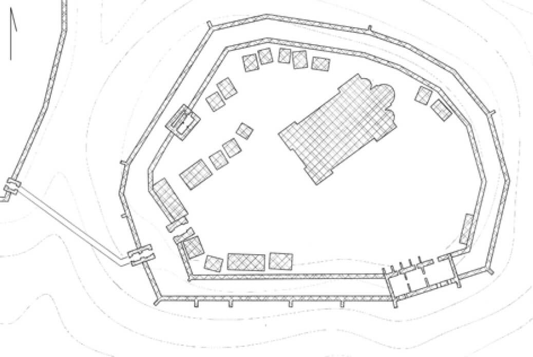
The brick castle wall was built on the site of older ramparts, so its plan was roughly oval, achieved by several short, straight sections of curtains, extending along numerous bends near the slopes and escarpments. The wall followed the line of the older ramparts most closely on the eastern and northern sides, while on the southern and western sides it may have encompassed a smaller area than the older fortifications. The defensive perimeter may have been shortened due to the uncertain statics of the slope. Entry was from the west, likely via a long wooden bridge spanning the ditch, placed diagonally to the gate. In the 14th and 15th centuries, according to records, the castle consisted of two parts: a castellum and a castrum, perhaps reflecting the division of the courtyard into utility and residential areas. By then, the entire hill was already surrounded by a double ring of walls in an irregular semicircle. The first ring was built by Bolesław II in the late 13th or early 14th century, and the second by Kazimierz the Great in the second half of the 14th century, although it is uncertain which ring of fortifications belongs to which ruler (the inner one was probably founded by Bolesław, while the expansion by Kazimierz the Great most likely took place outside the older perimeter). The outer wall was certainly slightly lower and less massive than the inner perimeter.
The oldest brick residential and defensive structure on Tum Hill was a quadrangular, trapezoidal structure measuring 14.4 x 10.8 meters, likely located in the northeastern corner of the castle from the second half of the 13th century. It was built on erratic granite foundations, while the above-ground sections were constructed using the opus emplectum technique, with faces made of carefully crafted granite blocks. Its walls were as thick as 1.8 meters at ground level, suggesting it could have been a residential tower, likely two or three stories high, with walls gradually tapered by offsets. The building was incorporated into the northern section of the fortifications, which were still constructed of wood and earth.
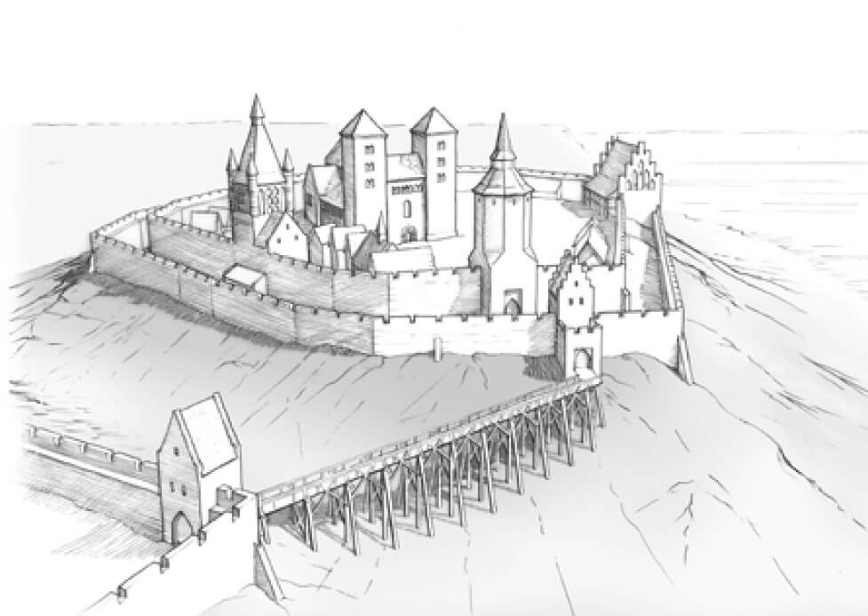
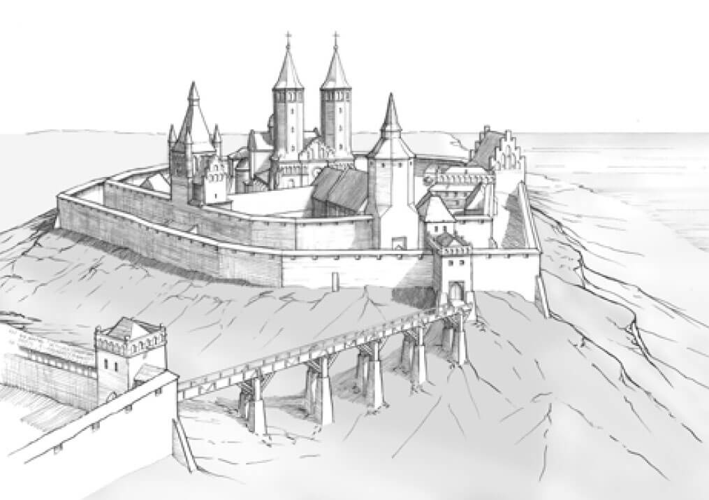
The entrance to the Gothic castle was on the western side, within two gatehouses, one each on the outer and inner perimeter of the walls. Another gate may have been on the northern side. It is known that in later times two more posterns operated, one near the cathedral and the other on the south, leading towards the Vistula River. However, it is uncertain whether these were opened as early as the 14th or 15th century. The gate in the western section, as it was during the older stronghold’s existence, was preceded by a wooden bridge spanning a ditch, facing the town. This bridge was first recorded in 1472, when a certain Małgorzata sold the nearby horse mill. Shortly after 1506, the main gate was relocated slightly to the southwest, in order to free the cathedral from the noise caused by people and animals.
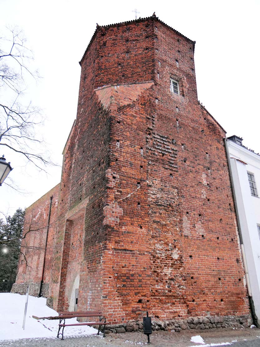
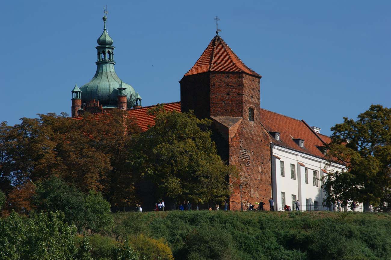
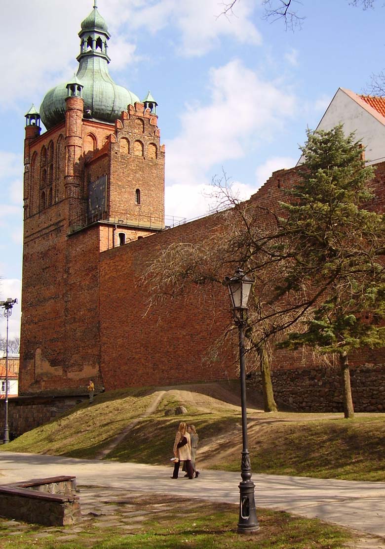
The western gate tower in the inner ring of the defensive wall was the Noble Tower, also known as the Great Tower. It was erected on a quadrangle plan measuring 10 x 9.8 meters, with a wall thickness of about 2.7 meters, passing higher into the octagonal part. Originally served as a gate located in the line of the inner perimeter of the defensive wall. Its ogival passage, 3.25 meters wide and 5 meters high, was framed with stones and a recess adjoining the raised drawbridge. Undoubtedly, originally it also housed a door, blocked by a timber drawbar. It was walled up in the first half of the 15th century (or at the beginning of the 16th century) and a new gate was created on the southern side. However, the former passage began to serve as a prison to which the convicts were dropped from the upper opening. In the north wall of the tower, at the height of the third floor, there was an opening leading to the defensive wall-walk. On this floor there was also a seven-sided room, in which north-eastern corner there was a fireplace, and in the southern wall a window.
The Clock Tower was erected in the northern corner, on the relics of a residential tower from the 13th century, and because of this its outer wall was on the defensive wall line, and the interior was drawn deep into the courtyard, which was not a favorable solution for defensive reasons. When at the end of the 15th century the towers of the cathedral that were threatening to collapse could not hold the bells, they were moved to the Clock Tower, which was raised by an additional floor. It was then crowned with round corner turrets. The perimeter wall of the castle near the Noble and Clock Tower was 2.38 meters thick. It had a defensive porch (wall-walk) covered by the breastwork and topped with a battlement with merlons 3.6 meters wide, positioned at 80 cm intervals. The battlements probably had slit loop holes.
The gothic residential house was adjacent to the bent section of the wall between the two towers. It was a two-story building and a mono-pitched roof. Even before the end of the fifteenth century, it was expanded, but it was not the main ducal house, but only an auxiliary building. Importantly, it was attached to the existing perimeter wall, using its thickness to accommodate communication devices. The most important houses stood along the eastern and southern curtains away from the hustle and bustle of the gate complex and the northern part of the complex, in which the church and Benedictine monastery, cathedral and clergy were located. The prince’s palatium (palas) was located in the southern inter-wall area, between the wall of Bolesław II and the wall of Kazimierz the Great. It was mentioned in 1437, but it was probably created much earlier, during the fourteenth century construction works. In the fifteenth century, in addition to the cathedral, the timber church of St. Adalbert functioned at the castle (between the Noble Tower and the entrance to the cathedral), and the survey from 1498 mentioned a bakery, a stable, a castle crew’s house, and a scribe’s house.

Current state
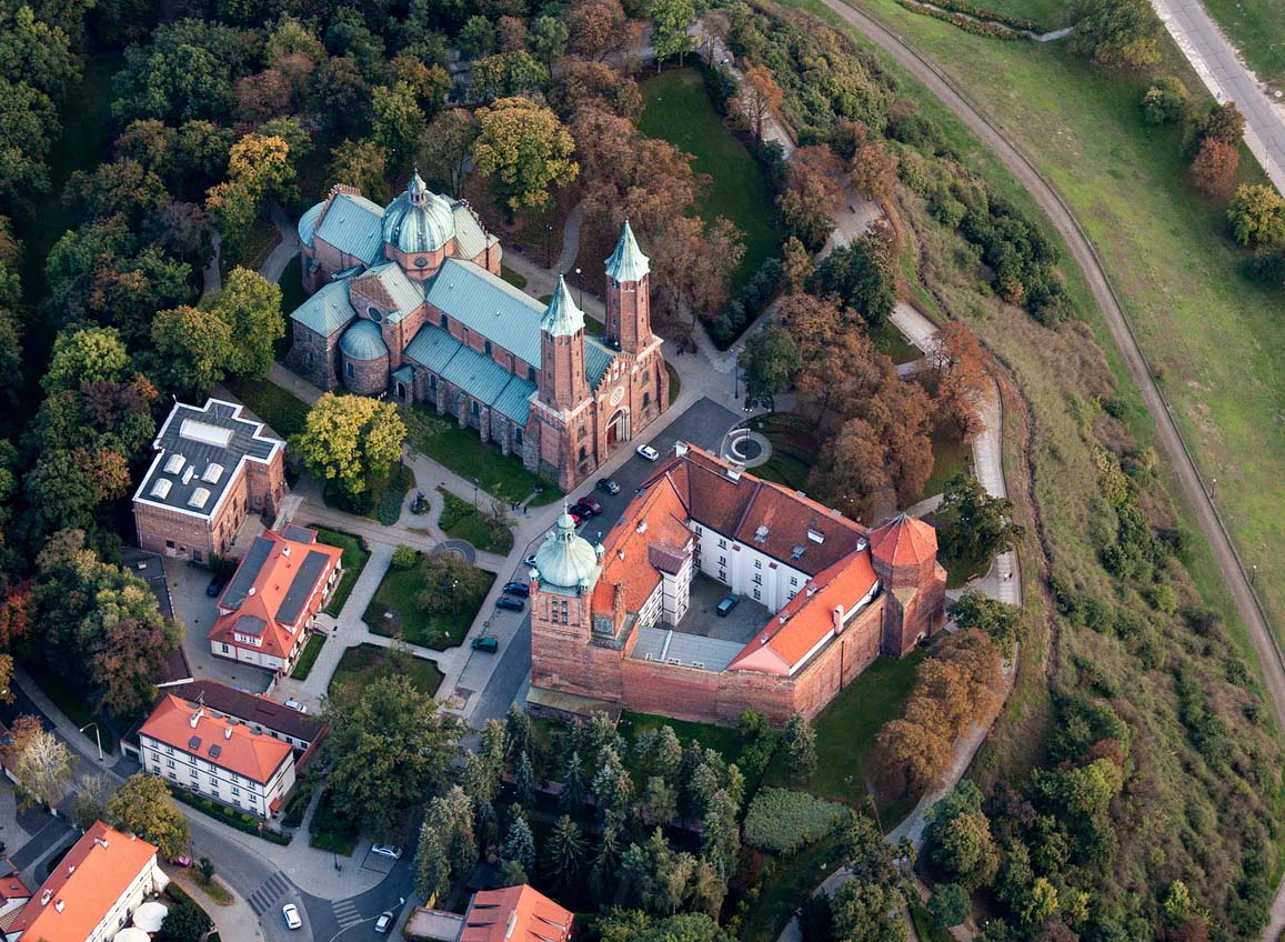
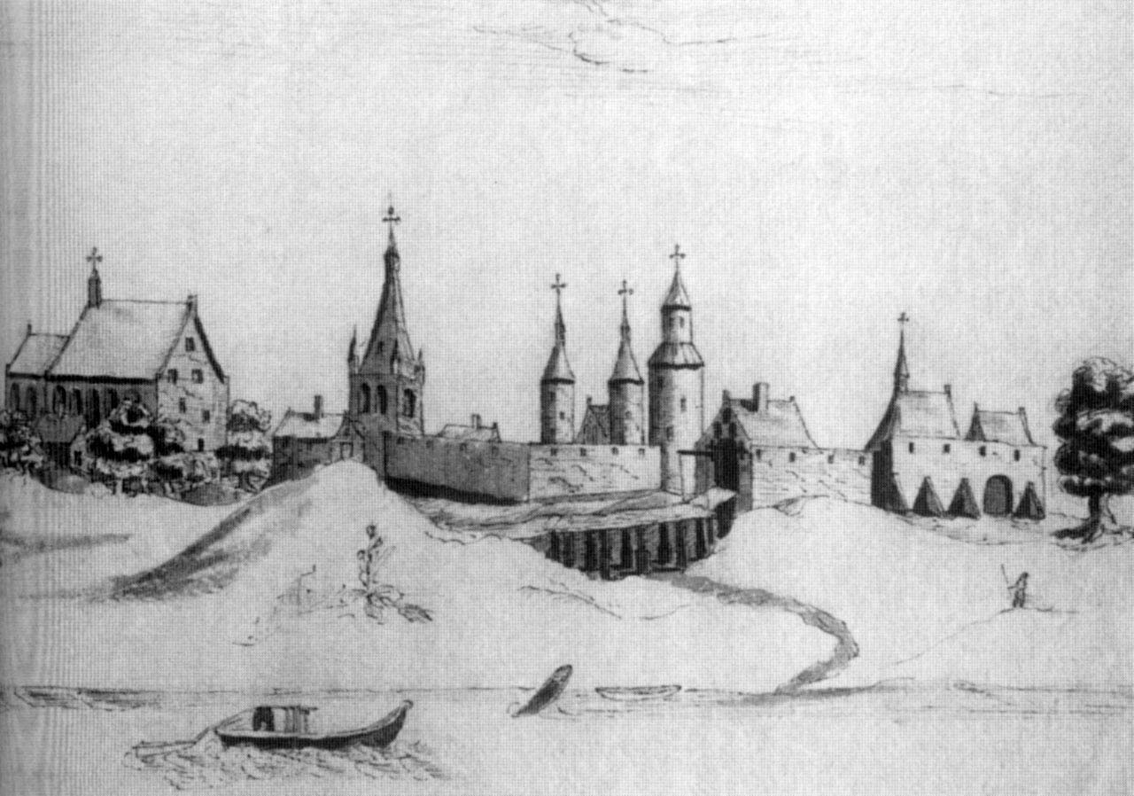
Currently, after a thorough rebuilding and reconstruction during which older relics were being shown, the castle is one of the most important tourist attractions of Mazovia. From the old medieval castle remained the Clock Tower, a former tower elevated and rebuilt around 1492 to the cathedral belfry, and the Noble Tower, which was reduced to the middle in the 18th century. A fragment of the wall to which the wing of the Benedictine monastery adjoined, is also preserved. It is Museum of Masovia located in it.
bibliography:
Bukowska A., Trzeciecki M., Relikty architektury kamiennej na Wzgórzu Tumskim w Płocku – wyniki badań weryfikacyjnych [in:] Architektura romańska w Polsce. Nowe odkrycia i interpretacje, red. T.Janiak, Gniezno 2009.
Kacperska J., Płock jako siedziba książąt mazowieckich, “Notatki Płockie”, 3/2012.
Lasek P., Zamek w Płocku. Zarys dziejów budowlanych do 1655 roku [in:] Residentiae tempore belli et pacis Materiały do badań i ochrony założeń rezydencjonalnych i obronnych, red. P.Lasek, P.Sypczuk, Warszawa 2019.
Leksykon zamków w Polsce, red. L.Kajzer, Warszawa 2003.
Płock wczesnośredniowieczny, red. A. Gołembnik, Warszawa 2011.
Żabicki J., Leksykon zabytków architektury Mazowsza i Podlasia, Warszawa 2010.