
History
Olsztyn (Allenstein) received the foundation privilege from the Warmia chapter in 1353. At that time, the founder Jan of Łajsy was given the task of demarcating the town limits in the bend of the Łyna River, situated on the line of the meridional route, next to an older castle and a watermill. The town could then be fortified with temporary wood and earth fortifications, but the construction of a brick defensive wall probably began after 1378, when the area of Olsztyn was enlarged by the Fish Market and the so-called New Town.
The town defensive walls were initially intended to protect Olsztyn primarily against the raids of Lithuanians, who in the 14th century ventured into the areas of southern Warmia through the Galindian Forest. After the foundation of the town, the first of these raids took place as early as 1356. In the fifteenth century, the town was captured several times during the Polish-Teutonic wars. It suffered severe damages especially during the Hunger War in 1414, as well as during the Thirteen Years’ War in 1459 and 1463. During the Priest War of 1478, the town was no longer besieged, but after bad experiences from previous years and due to the development of firearms, at the end of the 15th century, the fortifications of Olsztyn were reinforced with a second line of the defensive wall. This enabled the effective defense of the town by the canon Nicolaus Copernicus during the Prussian War in 1521, although the Teutonic Knights unit that tried to break through the walls was not too strong.
In 1620 and 1657, during the town fires, the wooden structural elements of the walls, ceilings and roofs of the towers burned down. Great damages were also caused by the Northern War, during which the Swedes burned the town in 1708. The Upper Gate was destroyed then. It was quickly repaired, but the outer wall was left ruined. Other fragments of fortifications began to be transferred to private hands, which involved covering the curtains with residential and economic buildings and transforming the towers into dwellings. From the end of the 18th century, the neglected walls completely lost their defensive significance. Gradual demolition began, of which bricks and stones were used for new construction projects.
Architecture
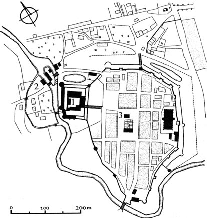
The town was founded in a bend of the Łyna River, which protected Olsztyn from the west and south. In the north-west corner there was a castle, connected to the town’s defensive perimeter, but at the same time separated from it by a moat and its own wall. Near the town walls, in the eastern part of the perimeter the church of St. James was situated, which as a massive, brick hall on a rectangular plan, located parallel to the line of fortifications. It probably also played an important defensive role, or at least a guard and sentry role.
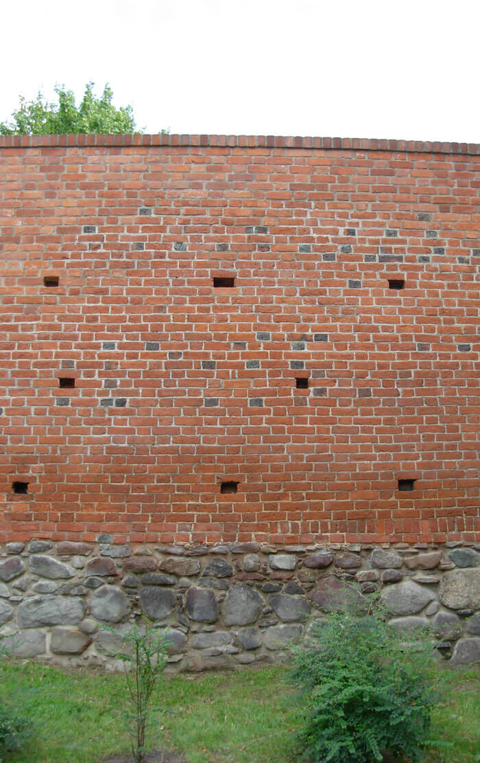
The defensive walls of Olsztyn were built of bricks with a Flemish bond, on a stone foundation. It were 1.6 to 2 meters thick and about 5-6 meters high from the town side, from the ground to the offset (total height including the parapet was about 8-9 meters). The wall-walk used to move the defenders was placed on the above mentioned offset. Along the entire length of the perimeter of the walls, there were several towers, mostly rectangular and opened from the town side, and cylindrical ones in places that were crucial from the defense point of view. The towers were not arranged regularly, as was the case in Teutonic Knights towns, but densely packed depending on the natural defensive conditions of the area.
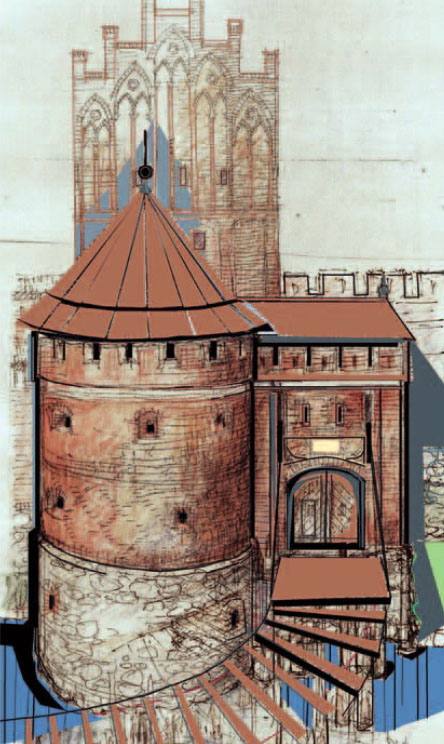
The entrance to the town was provided by two gates: the Upper Gate, also called the High Gate on the north side and the Lower Gate on the south side. Both were located on the longitudinal axis of the Olsztyn, at the end of one of the main streets, which was connected to the corners of the market square located in the center of the town. There was a moat in front of the Upper Gate, while the Łyna riverbed ran right in front of the Lower Gate. In addition, at the castle, in the north-western part of the perimeter, there was a postern called Mill Gate, the Water Gate was directed towards the river, and another postern was located at the Lower Gate.
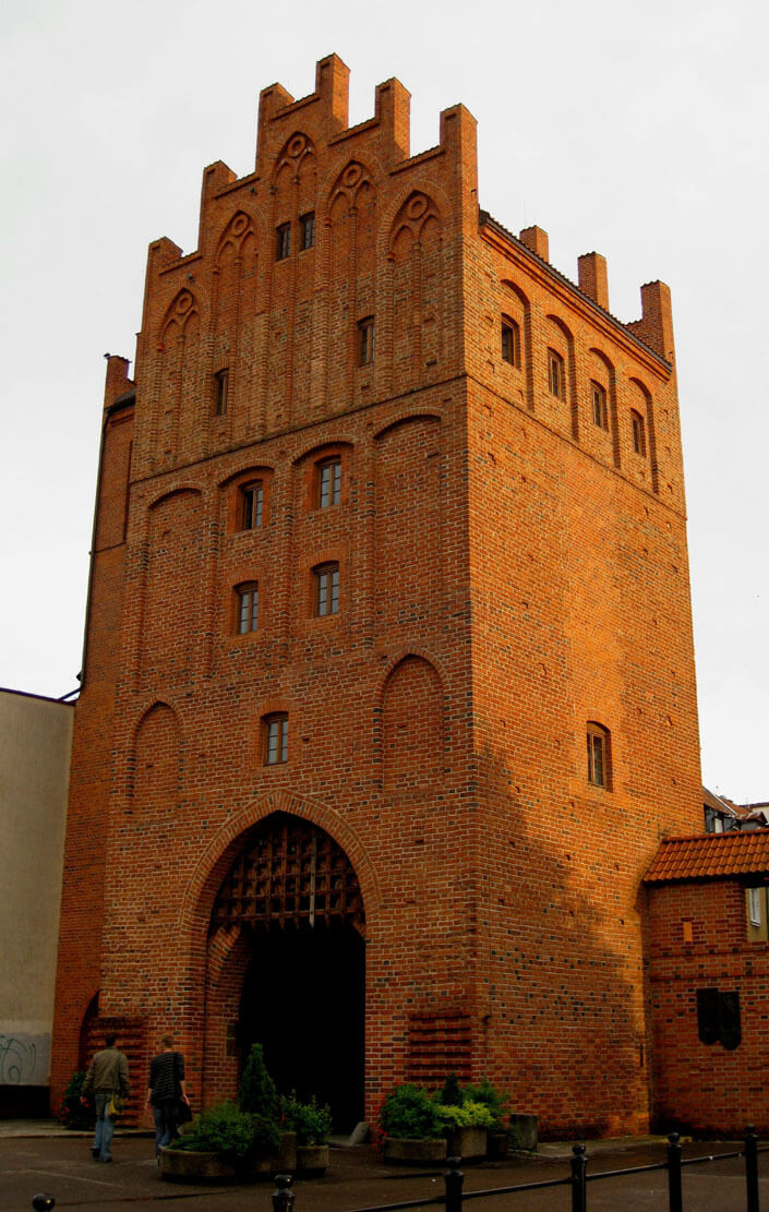
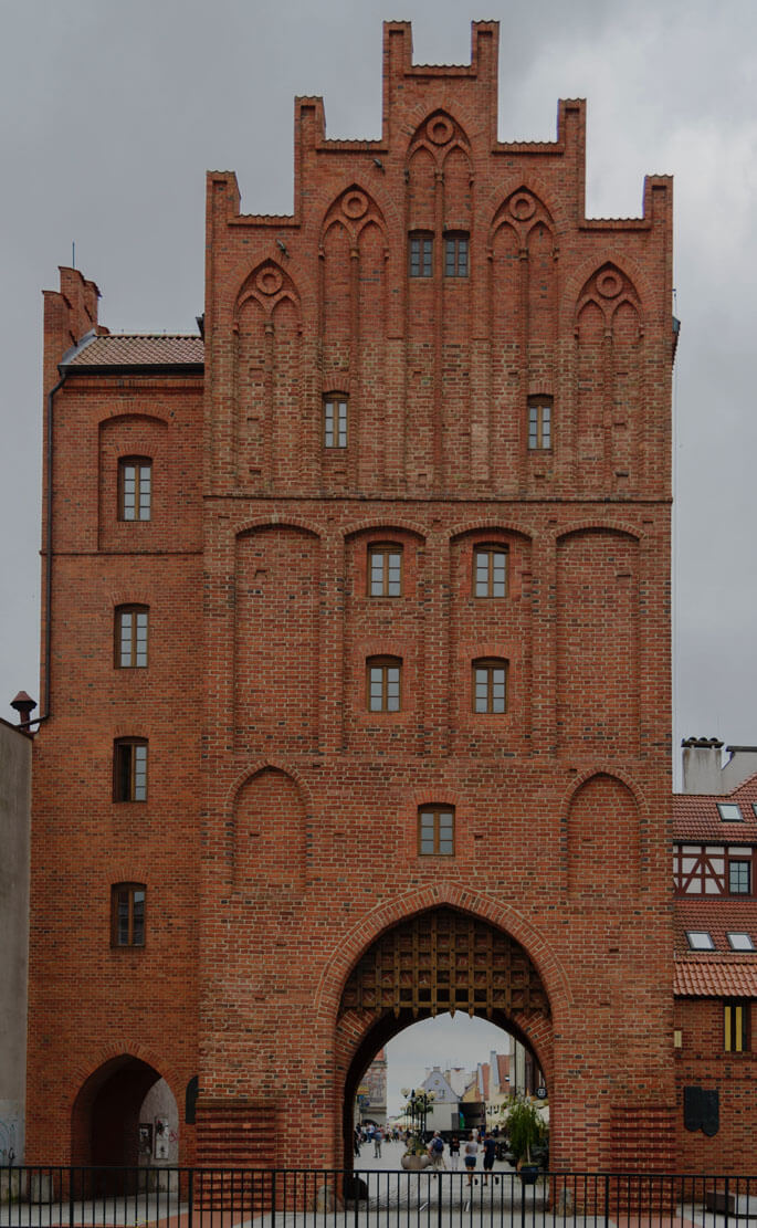
The Upper Gate, after the rebuilding from the 15th century, obtained the form of a tower on a plan similar to a square with a side of 9.5 meters. Four storeys were created with a kind of fifth storey was in the gable part. The cover was provided by a gable roof and stepped, five-axis gables decorated with pointed, bipartite blendes. The internal façade, facing the town, was also decorative, covered with a regular rhomboidal pattern made of zendrówka brick. In the ground floor there was a gate passage, closed with a portcullis set in guides near the external exit. The passage was covered with a cross vault, while the upper floors were separated by wooden ceilings. The gate tower had a foregate, with the neck walls 12 meters long and 1.8 to 2 meters wide. The neck from the outside (field side) ended with a corner, cylindrical tower with a diameter of 11 meters.
The convenient location of the town in the bend of the Łyna meant that more than half of the town walls were additionally surrounded by the course of the river. The remaining part was protected by a moat 30-40 meters wide, irrigated with water from the Łyna. At the end of the 15th century, in places where the town was not surrounded by a river, but only by a moat, i.e. from the south-east and east, an additional external, low wall was built. This wall was separated from the high wall by a zwinger, additionally it was equipped with semicircular bastions. It ran parallel to the high wall. The distance between them in the north-eastern section was to be about 12.5 meters, while in the south-eastern section it did not exceed 10 meters. Because the outer wall did not run around the entire town, in the south-east it ended with a transverse wall with a cylindrical tower. In addition, on the outside of the moat, there was another counter-escarpment wall.
Current state
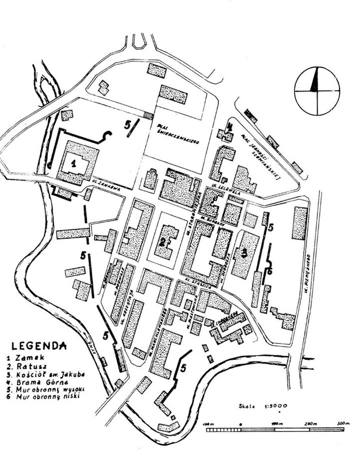
Several isolated sections of the defensive wall, both the main one and the outer one, have survived to the present day, especially in the southern, south-western and eastern parts of the former perimeter. Near Okopowa Street south of the castle there are numerous fragments, including 17, 19 and 57 meters long. Another section of the reconstructed wall at Okopowa Street is located on the eastern side of the castle. Fragments of the walls are also visible at Piastowska Street and Bolesława Chrobry Street, as well as between the parish church and Pieniężnego Street, where the bastion of the outer wall has been preserved. Some of the curtains today serve as the outer walls of modern houses. The most interesting element is the Upper Gate, located in the northern part of the Old Town complex. Currently, a slightly lower annex from the 19th century is added from its eastern side. The foregate has not survived (in recent years its remains have been discovered and made visible), during the Second World War the vault of the gate passage collapsed, and the gables had to be partially reconstructed.

bibliography:
Biała karta ewidencyjna zabytków architektury i budownictwa, mury obronne, W.Chodkowska, nr 6279, Olsztyn 2002.
Czubiel L., Domagała T., Zabytkowe ośrodki miejskie Warmii i Mazur, Olsztyn 1969.
Kaczyński B., Mackiewicz A., Badania archeologiczne przedbramia Bramy Górnej w Olsztynie, “Olsztyński rocznik konserwatorski”, Olsztyn 2014.
Rzempołuch A., Architektura i urbanistyka Olsztyna 1353-1953, Olsztyn 2004.