
History
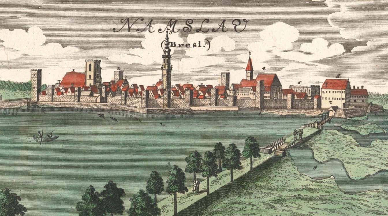
Around the middle of the thirteenth century, Namysłów (Namslau) was founded on the Środa Law, and at the end of that century it was surrounded by wood and earth fortifications. The construction of brick town fortifications began before 1348 on the initiative and with financial support of the Czech king Charles IV, who partially financed their costs.
The eastern section was the first to be erected, the most accessible and endangered one, then the southern fragment with the Wrocław Gate tower built in 1390. The modernization of the eastern section of the fortifications was carried out alrready at the end of the fourteenth century, when some of the towers were raised, the Bakery Tower was erected in 1394, the tower of the Kraków Gate in 1396 and the Tavern Tower was built two years later. The works were completed at the beginning of the 15th century with the northern section and the Water Gate, erected around 1415. Later, in the years 1471-1497, a lower outer wall was built with cylindrical towers, which only the eastern section of the Namysłów fortifications did not have. They were probably considered unnecessary there, due to the additional protection in the form of a second ditch existing since 1428.
In early modern period renovation works on the defensive walls were carried out in the 16th and 17th centuries, and for the last time in the first half of the 18th century. In the second half of the 18th century, old and unnecessary town fortifications were gradually demolished and removed, especially the underwall street and the zwinger area were occupied by buildings. This process intensified in the nineteenth century, and the building materials taken from the fortifications was used to erect new buildings next to them. On the site of the former moat, a promenade was arranged around the town.

Architecture
The terrain and the Widawa River, flowing along the northern border of the town through a wide, wet valley, meant that the Namysłów was most at risk from the east. An irrigated moat was dug from this side and from the south and west, in front of the perimeter of the defensive walls. The backwaters of Widawa from the east and north-west provided additional protection, while a castle was built at the end of the promontory on the west side of the town.
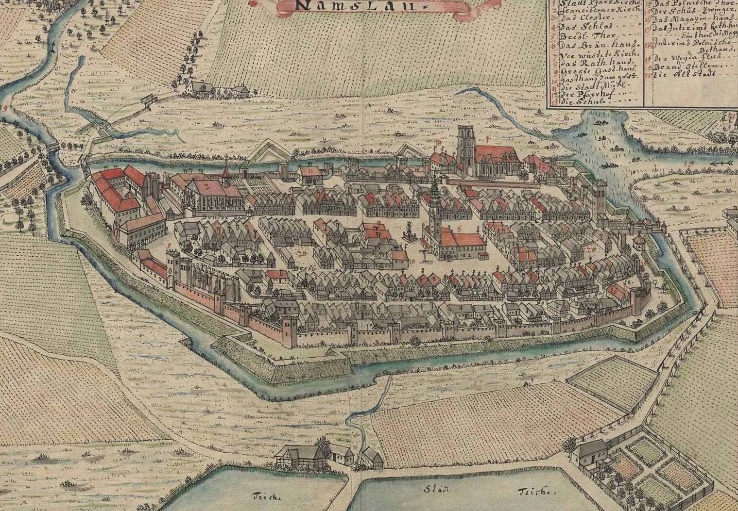
The defensive walls of Namysłów were built of bricks with a Flemish bond, on some sections they had a foundation made of stones. The perimeter on the north and south was 1.7 meters thick, the walls on the east 2.2 meters thick. Their height was from 4.5 (at the Krakowska Gate) to 6 meters without taking into account the battlement, which was slightly over 2 meters high. The merlons, 3.1 meters long, were spaced at intervals of about 1 meter, and at least in some sections the crown of the wall was equipped with a hoarding porch. Initially, the bare wall-walk in the crown of the defensive wall, in the fifteenth century, due to the development of firearms, was roofed to avoid the dampness of the gunpowder among the defenders.
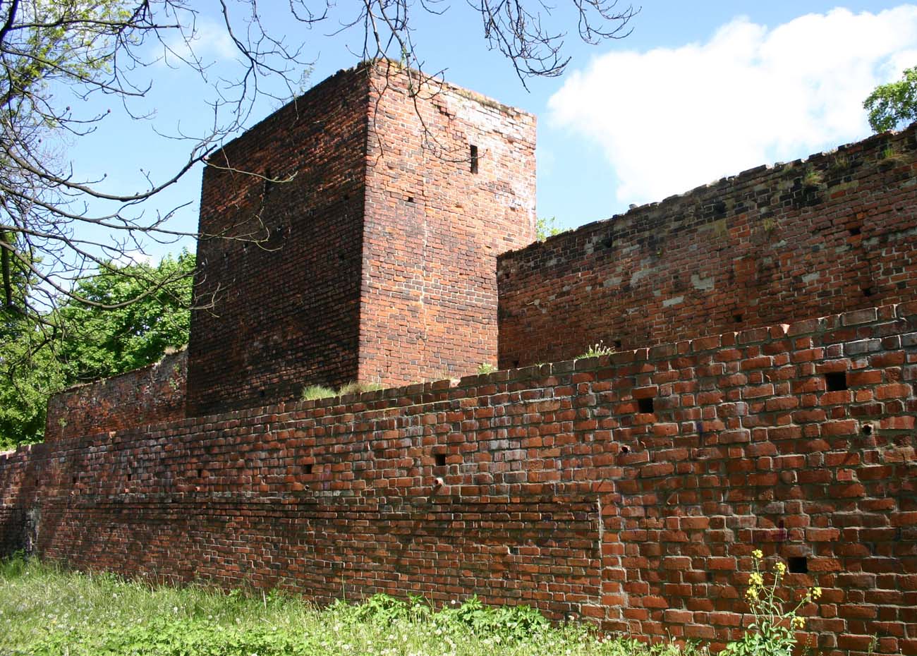
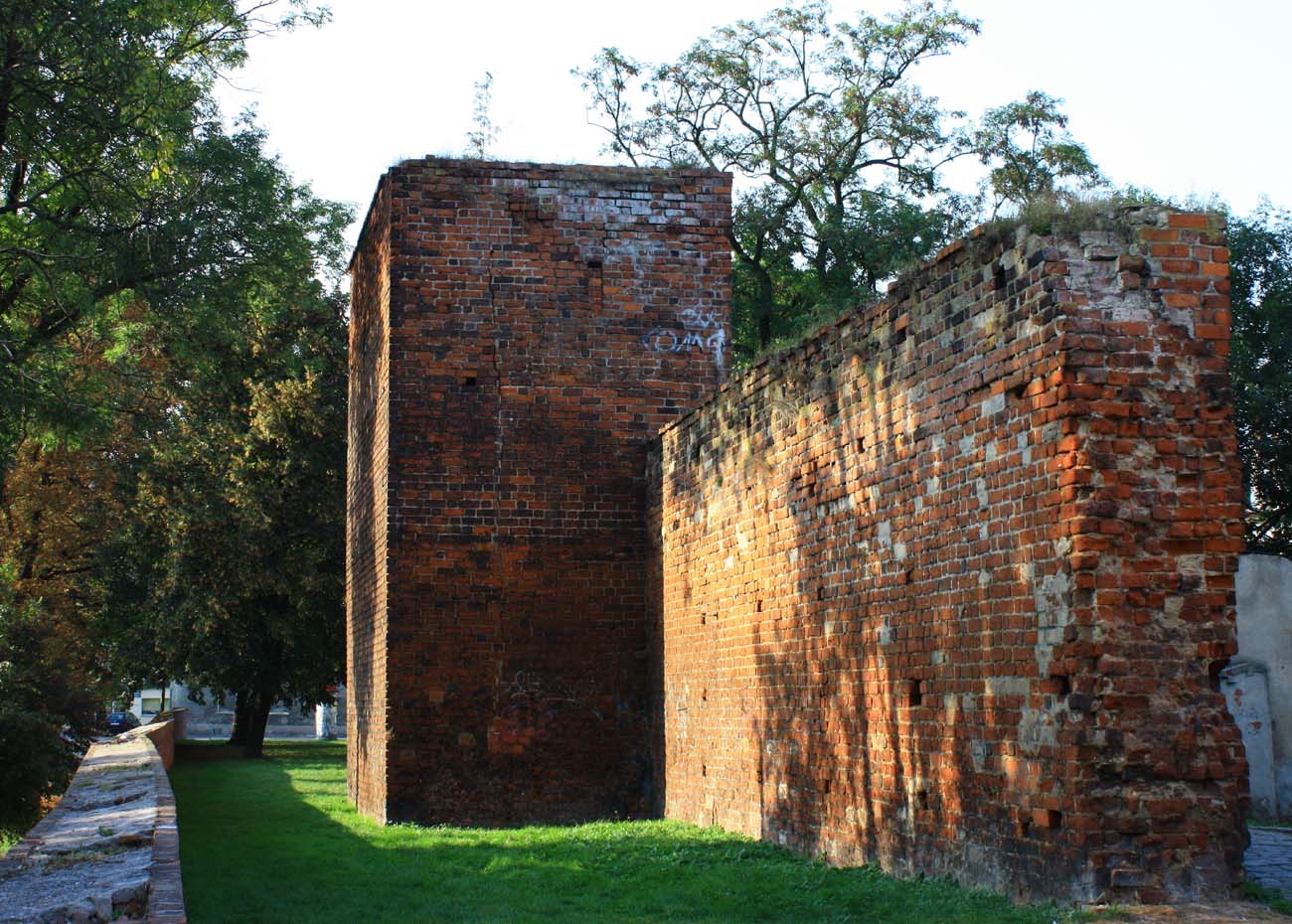
The ring of the walls was reinforced with about 37 towers of various forms, arranged irregularly at distances from 21 to 36 meters, i.e. at a distance of an effective crossbow shot. They protruded a few meters (about 4-5 meters) in front of the face of the perimeter wall, with the towers in the southern part of the perimeter of the fortifications the least extended, where the curtains of the walls reached the center of their side walls. Initially, some of the towers were probably open from the town side. More massive towers with a closed form were erected in the most critical points of defense, i.e. in the eastern corners (Tavern and Bakery towers). Two more massive four-sided towers flanked the Wrocław and Kraków gates. In addition, in the northern part of the circuit, in the bend of the curtain between the towers, there was a dansker (latrine) tower, mentioned in the town chronicle from 1396. Due to the proximity of the river arm, two culverts were made in the nearby wall, supplying water to the town mill.
In the second half of the fifteenth century from three sides of the town was erected a second, outer ring of walls with semicircular and polygonal bastions. It was 0.7-0.75 meters thick, about 3-4 meters high and was reinforced with buttresses in at least some parts. During the implementation of the bastion circuit, the breastwork of the high internal wall was rebuilt, in which the top with battlement was replaced with a wall with loop holes and with a covered wall-walk.
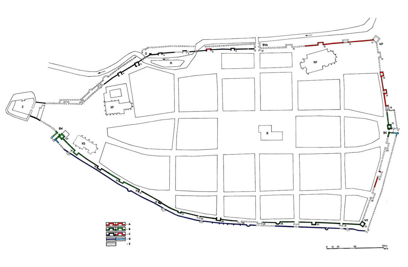
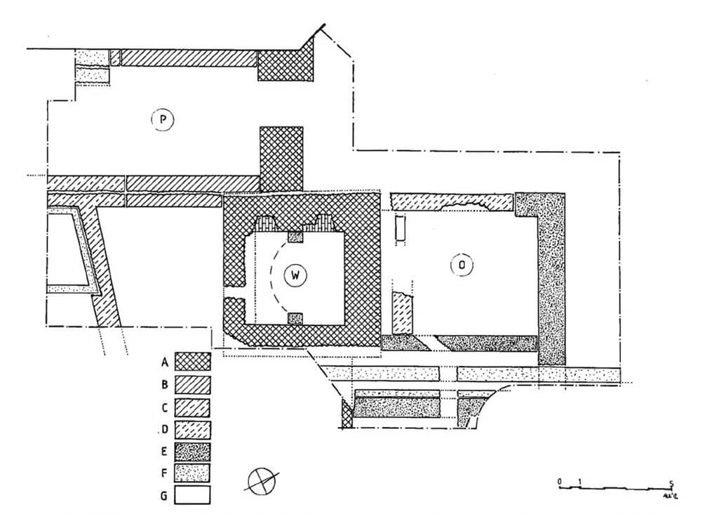
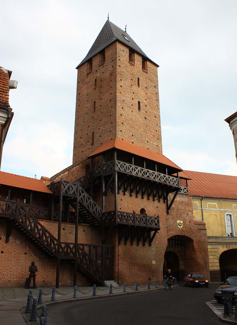
A west German gate led to Namysłów, also called Wrocław or Brześć, the east gate called Polish, Kraków or Kluczbork and the so-called Water Gate. The Kraków Gate was flanked by a high four-sided tower with dimensions of 7.6 x 7.8 meters and a wall thickness of the first floor 2.5 meters. Its height was originally about 28 meters. Its lowest storey was a vaulted prison dungeon, accessible only through an opening in the vault, while the upper floors, of which there were at least six, were covered with timber ceilings. Communication between them was provided by ordinary ladders. The entrance to the tower was on the town side in the west elevation, at a height of almost 10 meters, in a semicircular topped portal. It was placed at the level of a wooden porch, which was supported by corbels embedded in the walls. It probably connected the porch of the wall on the northern side of the tower with its storey above the gate passage. Inside the tower, the individual floors were illuminated by slit, spalyed openings. The gate passage itself, 3.5 meters wide, adjacent to the tower from the south, was protected by a door and a portcullis placed in a recess. Above the passage there was probably a wooden porch of a hoarding function. The gateway was preceded by a small foregate with a plan similar to a rectangle, about 6 meters wide and at least 8 meters long.
The oldest form of the Wrocław Gate was a tower with a plan similar to a square and a gate opening in the curtain. This tower, currently unknown in height and sides about 7.5 meters long, was built on a stone foundation 1.5-1.7 meters thick. At a distance of about 2 meters from it, in the curtain of the wall there was a gate opening 2.5 meters wide, perhaps of a semicircular shape with two windows above it. A drawbridge and the neck of the foregate led to the Wrocław Gate, and the entrance to the town from the east probably had a similar solution, because the archival plans show a bridge and on the other side of the moat a foregate flanked by turrets. Also in front of the Water Gate, located in the tower, there was a foregate with a drawbridge.
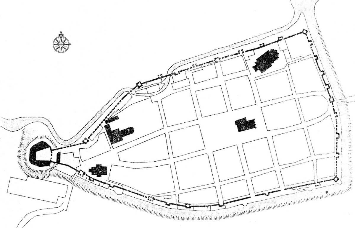
On the west side, the fortification ring was connected to the castle, equipped with its own walls. Perhaps, however, until the end of the fourteenth century, the castle, and earlier the hilllfort, were separated by the arm of Widawa from the town. Only then the river channel was diverted to the north, which was to be confirmed by the construction of the Castle Mill there. Thus, around 1400, the town would be enlarged by a western monastery and hospital district and, as a consequence, it would be connected by walls with a castle into one compact fortification system.
Current state
The main element of the fortifications that have survived to this day is the Kraków Gate, fragments of the defensive walls with towers have also survived in the north-west and north-east parts of the town. Among the inner city wall, you can see the eastern section running along Forteczna Street, consisting of the complex of the Kraków Gate, and a curtain with three towers reaching them from the north. On the northern side of the town, two sections are visible: the shorter one at the back of the parish church with one half-tower, and the longer one, stretching between the end of Armii Krajowej Street and the post-Franciscan monastery, with six towers preserved, as well as a relic of the dansker (latrine) tower in the area of the town mill. Among the inner city wall on the south side, you can see fragments of various lengths with seven differently preserved towers, including one semicircular. The outer wall has a broken line and three bastions. An interesting element are the two arcaded culverts in the northern wall, through which the Widawa river flows.


bibliography:
Atlas historyczny miast polskich. Tom IV Śląsk, red. R.Czaja, red. M.Młynarska-Kaletynowa, red. R.Eysmontt, zeszyt 11 Namysłów, Wrocław 2015.
Legendziewicz A., Problematyka badawczo-konserwatorska wybranych zespołów bramnych na Śląsku [w:] Obwarowania miast – problematyka ochrony, konserwacji, adaptacji i ekspozycji. Materiały Międzynarodowej Konferencji Naukowej, red. A. Górski, Kożuchów 2010.
Legendziewicz A., Średniowieczne fortyfikacje Namysłowa w świetle badań architektoniczno-archeologicznych [w:] Śląskie Sprawozdania Archeologiczne, Tom 60.2, Wrocław 2018.
Pilch J., Leksykon zabytków architektury Górnego Śląska, Warszawa 2008.