
History
The city fortifications of Malbork were created along with the construction of the castle complex from the fourth quarter of the 13th century, after receiving town charter in 1276 or 1286 from the Land Master Konrad von Thierberg. Originally, it consisted of wood and earth fortifications, transformed in the fourteenth century into brick structures on a stone foundation. The reconstruction of the town’s fortifications and the increase in its importance was certainly related to the decision to move the seat of the Grand Master from Venice to Malbork in 1309.
In 1410, after the defeat of the order at Grunwald, the town and the castle were besieged by the Polish-Lithuanian army led by King Władysław Jagiełło. Just before the siege, on the order of Grand Master Henry von Plauen, the town buildings which could provide support for the attackers were destroyed, but this did not stop Polish army from capturing the town on the second day after arriving at Malbork. The fights for the castle itself, despite almost two-month-long attempts to conquer it, turned out to be ineffective, so the captured town had to be abandoned.
In 1457, during the Thirteen Years’ War, King Kazimierz Jagiellończyk bought the town of Malbork and several other centers from mercenary troops, but in the same year the townspeople gave the town again to the Teutonic Knights. The castle, defended by Oldřich Červenka, who was in royal service, was surrounded by Teutonic forces. In the following years of the war, interrupted by frequent truces, Polish relief efforts blocked and unsuccessfully tried to capture the town. It was only when supplies were cut off and shipping on the Nogat was blocked, which forced the capitulation of Malbork in 1460, after which the mayor, one of the main initiators of the handover of the town to the Order, was sentenced to death. In 1466, under the Second Peace of Toruń, Malbork became a royal town.
In the second half of the 18th century, the medieval defense system of the town was already badly neglected and obsoleted, and its further devastation and demolition took place after 1772, after the first partition of Poland. In the mid-twentieth century, as part of rebuilding of the town after the destruction of World War II, the preserved fragments of the former perimeter of the walls were again partially demolished. The remains of the fortifications from the eastern and southern sides disappeared then irretrievably.
Architecture
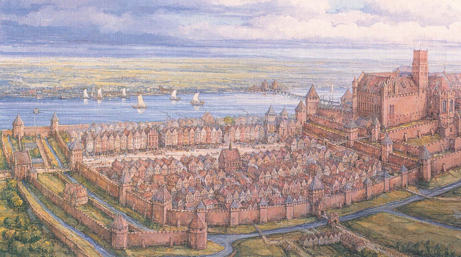
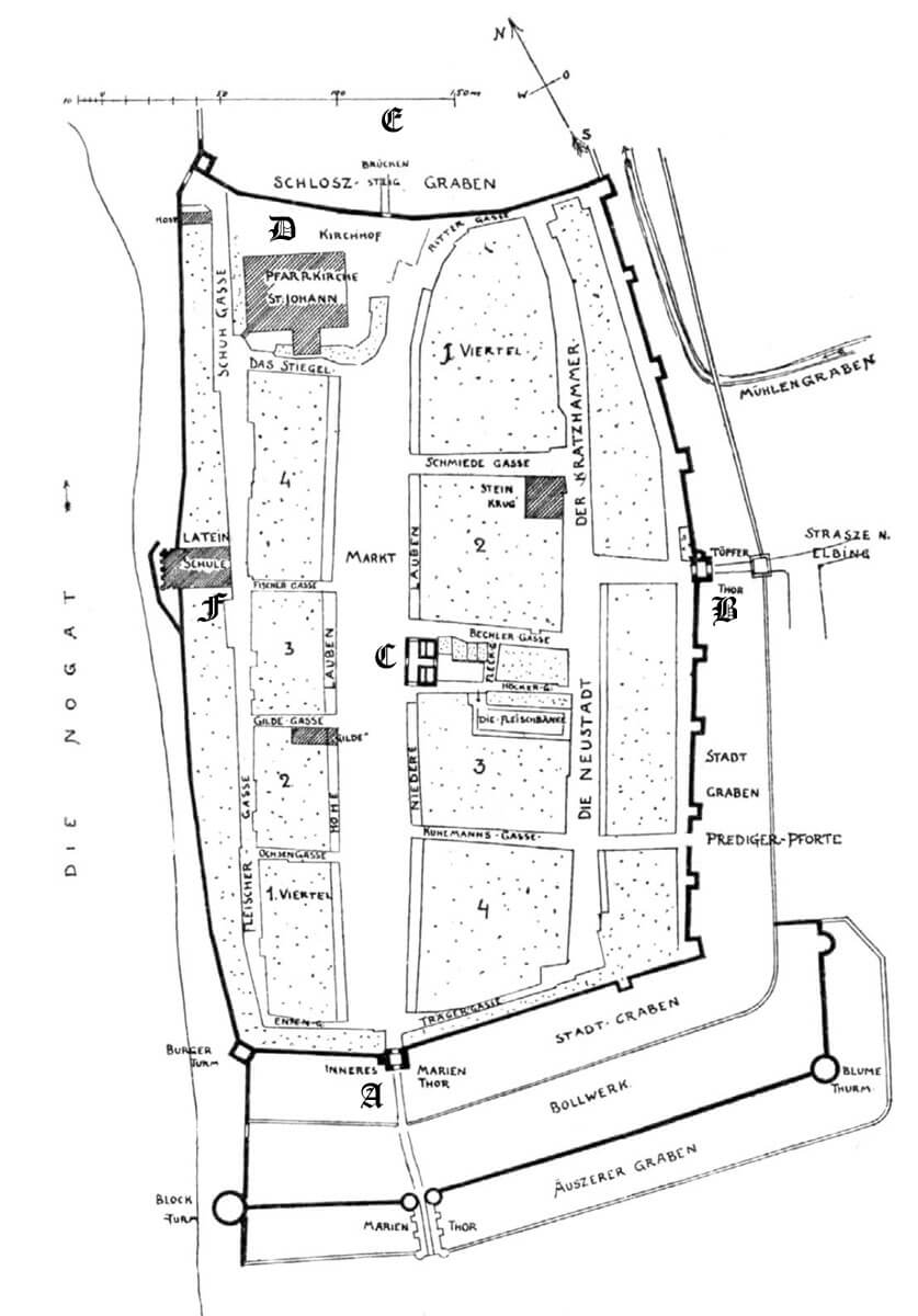
The town was situated on the eastern bank of the Nogat River, on the southern side of the Teutonic Knights castle. To the east and north-east, it was originally surrounded by a boggy valley, while the most natural approach was from the south. Walls obtained a roughly rectangular shape, elongated more or less along the north-south line. A very elongated market ran through the town, which was in fact a wide street, with the town hall more or less in the middle of its length. An under-wall street, if it existed, was only from the most endangered eastern and southern sides, while the economic riverside part could have been developed quite early (the riverside escarpment increased the protection there). The northern part of the town was probably undeveloped, due to the parish church located there and the vicinity of the castle, which had to have a clear foreground for defensive reasons.
The town’s defensive wall was built of bricks on a stone foundation. It had an arcade structure with a relatively thin wall thickness, which was 0.45 meters (1.5 bricks). From the town side, it was reinforced with 45 cm thick pillars, while from the field side, the access to it was secured by a moat. The town wall was supplemented with a dozen or so half towers, open from the town side, and at least one closed, full tower, in the south-west corner. The fortifications were the most extensive on the south side, farthest from the castle, and on the eastern side, most vulnerable to attack. Most of the towers were also located there. All of them protruded in front of the adjacent curtains, and it were higher than wall by at most one storey. The favorable defensive conditions did not force the townspeople to build towers from the river side, but more or less in the middle of that section, a four-sided building of the guild or brotherhood was erected, which could also perform defensive functions (the so-called Latin School).
In the late Middle Ages, the southern part of the fortifications was reinforced with a second, outer wall line with two cylindrical towers and one semicircular. The new fortifications were preceded by another, second moat through which the bridge of the outer gatehouse had to be placed. In the south-west corner of the town, the outer wall connected with the main defensive wall, while in the south-east corner it was probably separated by the bed of an older moat.
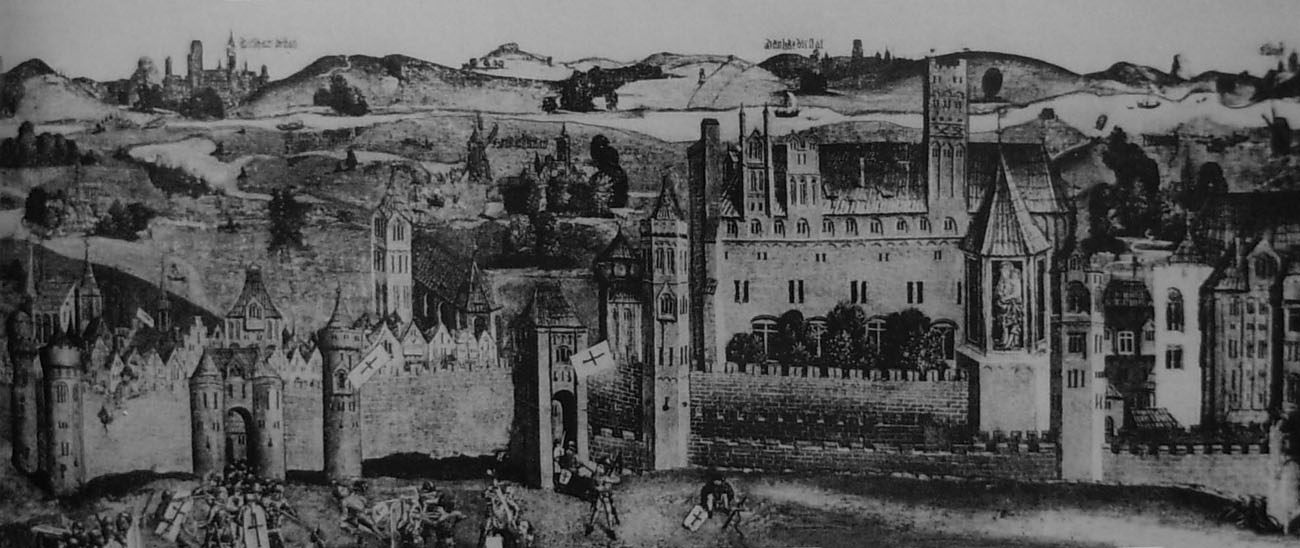
Two main gates led to the town: St. Mary’s Gate, also known as Sztum Gate, and the Pottery Gate, also called Elbląsk or Holy Spirit Gate, as well as the smaller Castle Gate. The St. Mary’s Gate was situated on the extension of the market square, while the Pottery Gate was connected to a short street connecting with a long road parallel to the town axis. The Castle Gate was probably only a portal pierced in the wall, without any major defensive features that, after a possible fall of the town, could be used by the besieging army. The gatehouse was only on the other side of the ditch, already in the line of the castle wall.
The St. Mary’s Gate had a rectangular shape with dimensions of 6.6 x 7.6 meters and a height of 10 meters. Its southern and northern façades, appropriately facing the foreground and the town, were decorated with pointed blendes, plastered friezes, coats of arms and tall recesses with pointed heads. In the outer, higher recess, a portculllis operated.
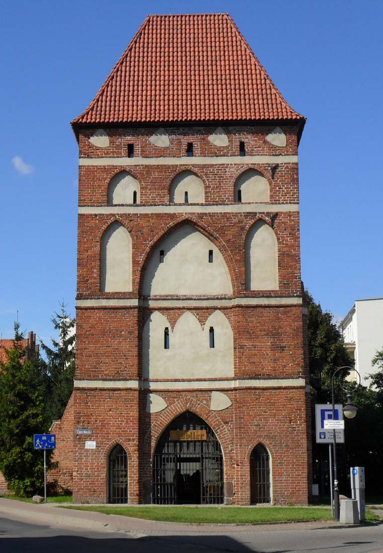
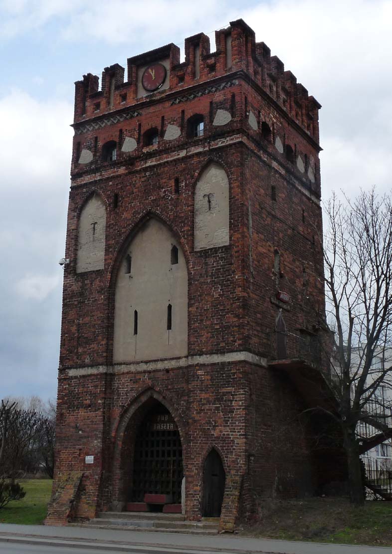
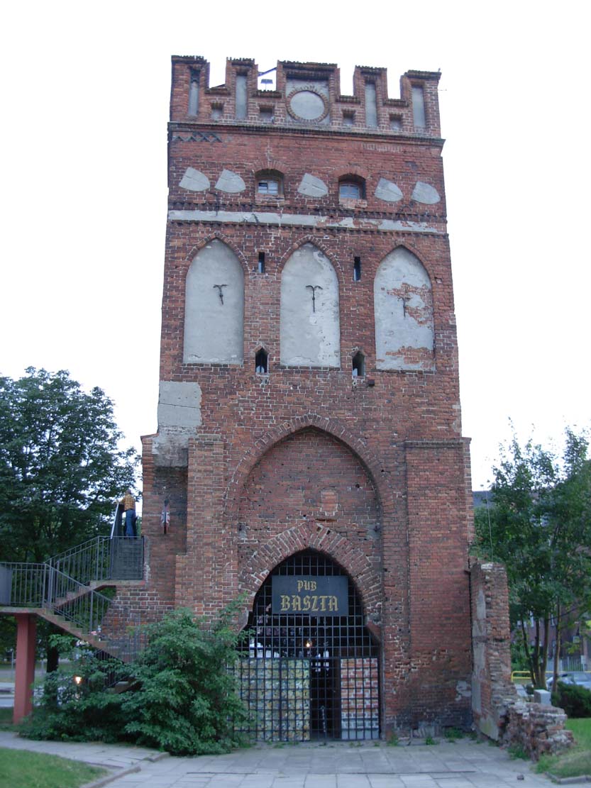
The Pottery Gate had five floors, was 12 meters high, on a rectangular plan with dimensions of 7.6 x 9.4 meters. In addition to the main passage, there were two pedestrian wickets in its ground floor. The eastern façade was shaped by wide friezes separating the storeys, blendes, coats of arms on the top floor, and arrowslits. The western facade was similar, but it did not have a large, pointed recess as on the opposite side. The west facade faced the town.
Current state
Among the medieval fortifications have survived the Potter’s Gate and relics of the half tower in the eastern section of the circuit, from the south the St. Mary Gate and from the west the retaining wall of the town’s plateau, on which the granary buildings were once based, and the so-called building of the Latin School. The latter has in recent years been rebuilt on the original, Gothic walls with the use of glass and concrete, which further disfigured Malbork’s old town, transformed into a communist housing district.

bibliography:
Herrmann C., Malbork, zamek i miasto, Olsztyn 2007.
Duda Z., Kryzia K., Mury obronne miasta Malbork, “Górnictwo i geoinżynieria”, zeszyt 2, Kraków 2011.
Leksykon zamków w Polsce, red. L.Kajzer, Warszawa 2003.
Schmid B., Bau-und Kunstdenkmäler des Kreises Marienburg, Die Städte Neuteich und Tiegenhof und die lädlichen Ortschaften, Danzig 1919.