
History
Lublin gained the first wood and earth ramparts in the middle or at the beginning of the second half of the 13th century. It must have happened before in 1286, when Prince Leszek the Black obliged the inhabitants of the hillfort to repair the embankments. They functioned at least until the town was founded under the Magdeburg Law in 1317. After obtaining town charter and setting out a new plan for Lublin, new fortifications covering a larger area had to be planned.
The beginning of works on the construction of defensive walls probably took place around 1342, and although it had to last a longer time, it is assumed that at the end of the reign of Casimir the Great, i.e. before 1370, the fortification ring was not yet closed around the town. The construction of stone fortifications was carried out as part of the reconstruction of Lublin after the Mongol invasion of 1341 and coincided during the period of a very successful development of the Lublin. This investment was related to the person of King Casimir the Great, who showed special care for Lublin and was the founder of a number of municipal buildings, probably including the walls. It is doubtful whether the town, after its complete destruction, could have been able to finance the costly works.
In documents, the earliest mention of Lublin’s walls was recorded in 1408 in the ownership register of lands, located “extra muros Civitatis”, that is, outside the town walls. The same term was also used to describe the location of the church of Holy Spirit, on the occasion of the town burning in the great fire of 1415. The earliest reference to town gates was also dated from a similar period. Namely, in the resolution of the city council of 1419, the “upper gate”, probably the Kraków Gate, was mentioned, which would mean that there was also a lower gate, the Castle Gate, at that time.
At the turn of the 14th and 15th centuries, the first works on the expansion of the city’s defensive system were undertaken, namely the Kraków Gate was raised. From the beginning of the 16th century, work on the modernization of fortifications gained greater momentum in connection with the development and spreading of firearms. The defensive walls and their maintenance were already in the hands of the town at that time, because the city council bought the mayor’s office in 1504 and from that time the city council was obliged to pay for the fortifications, although the monarchs continued to support the townspeople with privileges. The reconstruction included all elements of the fortifications, i.e. walls, towers and gates, which were, inter alia, adapted to the needs of small firearms. It is also known that at that time the foregate of the Kraków Gate and the tower called the New Tower or the Executioner Tower, located behind the town bath, at the back of the Fish Market, were built. Next to it, the house of the “master”, or executioner, was erected. An entry in the city register from 1526 recorded the transport of stones to the walls, where the work was performed by the bricklayer Stanisław with helpers. Information about the financing of works on the fortifications was also recorded in 1532, 1552, and especially in 1553 in the chapter of the city book entitled Reformatio Murorum.
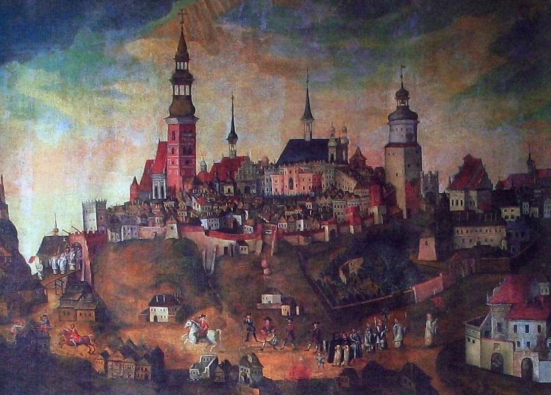
The works were intensified again after the dangerous town fire in 1575, which also damaged the fortifications. The reconstruction concerned mainly the Kraków Gate, the tower of which then received the highest octagonal part, and the timber elements of the towers and curtains (roofs, back walls and tower ceilings). Presumably, it was also during this period that the weakened curtains began to be supported with buttresses. All work on the repair of fortifications from the end of the 16th and beginning of the 17th century was the result of only the initiative of the municipal government. Characteristically, no early modern bastion defense system was introduced at that time, because what mattered was not the considerations of defense, but the representativeness of the entry to the city, which in 1578 received the title of the seat of the Crown Tribunal for Małopolska. The reconstruction was already carried out in the Renaissance style.
In view of the strong development of the town, the unfavorable for defense phenomena of building the foreground of the walls and adding buildings to the walls themselves began to grow early in Lublin. The town also had difficulties keeping the walls in proper condition since the 17th century. For this reason, Lublin let in Chmielnicki’s Cossacks in 1655 without a fight, and the Swedes a year later. The walls were damaged to some extent during the recapture of the town by Poles. In the eighteenth century, walls has definitely fallen into ruin. It was decided to demolish some of them and allow their western section to be built up, while both gates underwent a general renovation around 1785. The Castle Gate was then completely changed and lost its medieval form.
Architecture
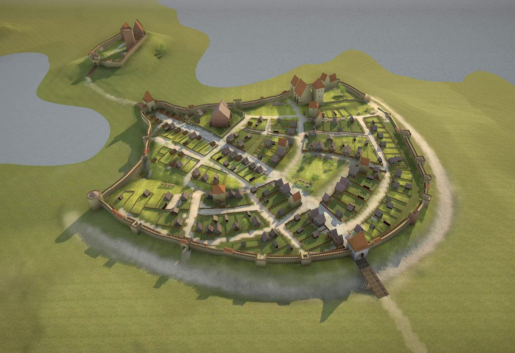
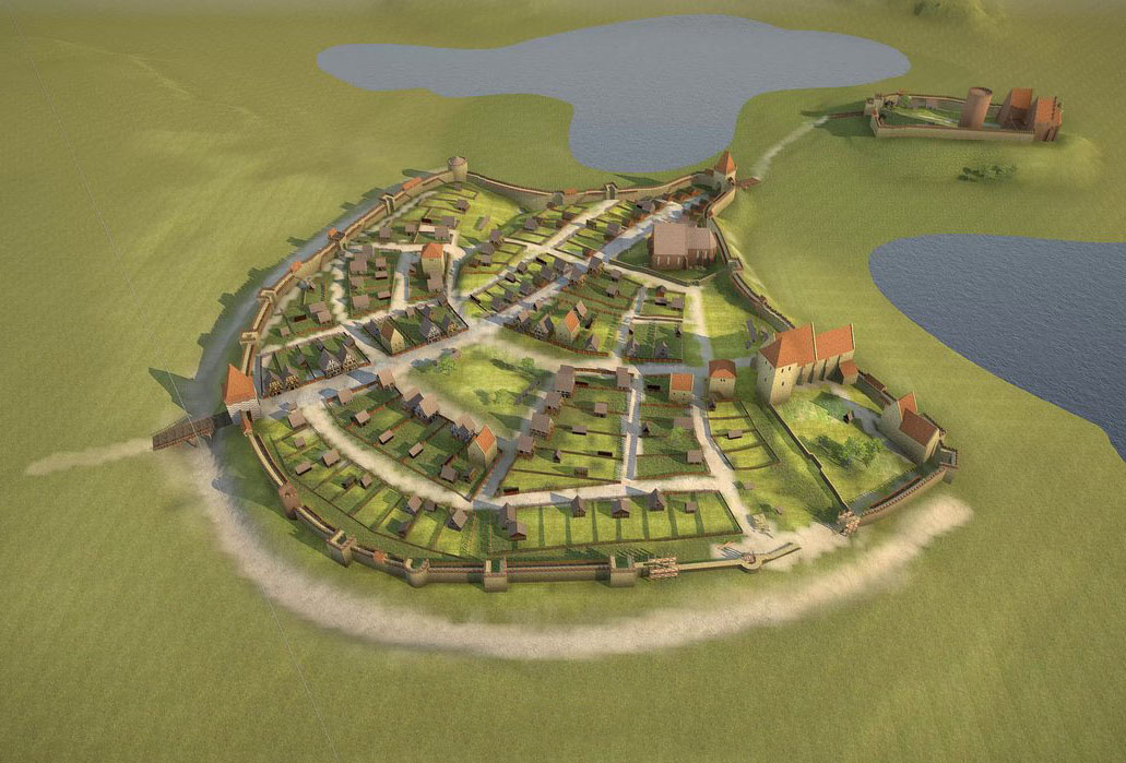
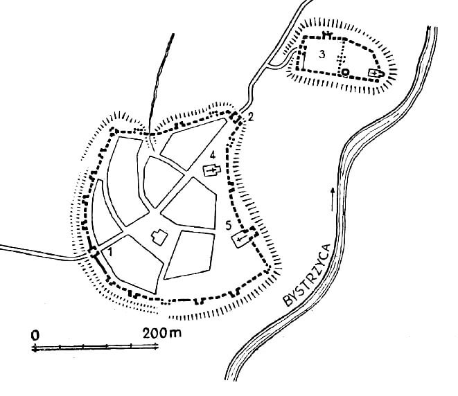
Lublin was founded on the northern side of the meandering Bystrzyca River, and at the same time on the western side of the Czechówka stream flowing into it. The confluence of both watercourses was wet and marshy, creating good defensive conditions, while the crossings through Bystrzyca operated in places of fords, south of the town, and also in the north-east, behind the Czechówka stream. There to Lublin led the main routes (the road in the valley of Czechówka could have protected by the stronghold on Białkowska Górka). The town itself was situated on a hill, originally occupied by the borough connected with the stronghold on the north-eastern castle hill. The stronghold, and then the castle, was not directly connected to the town. It was located behind the lowering of the ground and the narrowing created by the spilled waters of Czechówka, and another stream mentioned in the records, called Skrzyniczka. Created there the Great Royal Pond occupied the entire width of the floodplain, stretching from the mouth of the Czechówka to the Czerniejówka river, the right-bank tributary of the Bystrzyca, with the town hill higher than its water table by about 20 meters (the castle hill by less than 14 meters). From the north, north-east and south, high and steep slopes of the hill, and from the east and south-east also the current of Bystrzyca and the waters of Great Pond provided very good defensive conditions. From the west, the town hill turned into a plateau, although also carved with ravines.
The oldest medieval fortifications of the borough were situated in the northern part of the town hill, where they used a natural gorge in the vicinity of the later Fish Market. They consisted of an earth rampart and a ditch 3-3.5 meters deep and 9 to 12 meters wide. The rampart could reach 4-5 meters in height and about 10 meters in width at the base. It was probably crowned with an unknown wooden defensive structure. Such embankments may not have been from the extremely steep slopes in the north-eastern part of the hill, where the high slope was sufficient protection. When a stronghold and then a castle were built on the neighboring hill, a road was led through the headland of the town hill, permanently creating the main communication route, which was created in the phase before the town was founded. After the foundation of the town, the fortifications had to be moved to the foreground to cover a greater range, especially on the western side, which was the least defended by natural terrain conditions. A new moat was dug there, about 7 meters deep and 20-25 meters wide. The emerging network of streets of the town was adapted to the old defensive lines drawn in a semicircle, therefore the typical checkerboard grid of intersecting roads was distorted.
The circumference of the defensive walls was adapted to the terrain of the hill. It outlined in the plan a pear-shaped form, elongating and narrowing towards the north-east, towards the castle. The area of the town within the walls was about 7 ha, the total length of the fortification line was about 1100 meters. From the town side, the walls were surrounded by an underwall street, only the Dominican church, located in the south-eastern part of the perimeter, directly adjoined the walls, that were connected with the chancel. The underwall street was used for faster movement of defenders in the face of a threat, and facilitated the sending of reinforcements, weapons or supplies, and also separated the fortifications from residential buildings, which could protect them from burning in the event of a fire.
The wall in Lublin was erected in a mixed stone and brick technique, with the fact that on some fragments limestone was present inside the wall, and the face was made of bricks. The wall was 2.5 to 3 meters thick at the ground floor, and its total height was 7-8 meters. It was topped with a battlement, 0.6 to 0.8 meters thick, and an open wall-walk located behind the parapet (large width did not require widening with a timber porch), to which wooden stairs led from the town side. There were loop holes in the merlons. Later, perhaps at the beginning of the 16th century, the crown of the wall was modernized in some sections by bricking up the clearances and creating a continuous breastwork with arrowslits. After the reconstruction, in part of the western and northern sections, the defenders’ wall-walk was protected by timber, covered porches.
The wall was supplemented with towers, of which at least fifteen were created, and probably several more. Their spacing was the densest and the most regular from the endangered west side, where it was 35-45 meters spacing, less regular and less frequent than the north and south, and also in the south-east corner, in the area adjacent to the Dominican friary. The towers were rectangular in plan and, despite the diversified forms by reconstructions, it can be assumed that they initially had the same and typical form, i.e. they were extended in front of the walls and open from the town side. They could be equal in height to the wall or one story higher than it.
In addition to the typical towers, in the north-west corner of the town there was a full, round tower. The four-sided tower behind the parish church had an exceptionally large width of about 8 meters and two bartisans at the corners, which reduced the blind spots of fire, and at the same time made possible to observe distant approaches. Another unusual object was the semicircular tower, the first to the south-east of the Kraków Gate. It was built in the fifteenth century, as indicated by its late-gothic architectural form, but judging from the spacing, it could have been built in the place of the original one. This radical method of reconstruction from scratch was used in this case atypically, because most of the remaining towers were only modernized, received back walls and roof coverings, and some of them had high polygonal superstructures. In the ring of fortifications there was another semicircular tower in the southern part of the perimeter, and a semicircular structure called Dominican Tower from the place of its location, together with the nearby four-sided tower. Dominican Tower was pulled into the interior of the defensive circuit, so it was not a typical tower, but perhaps a structure related to the Dominican Postern, known from documents.
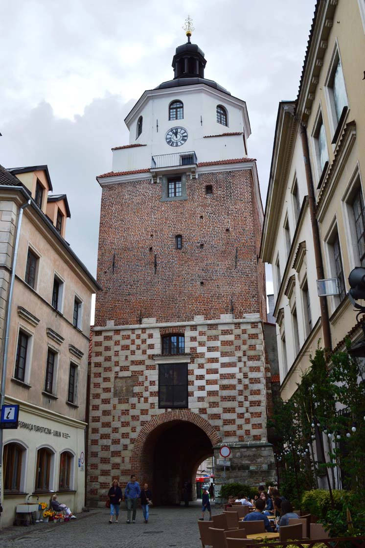
The town had two main gates: the Kraków Gate from the south-west, and the Castle Gate from the north-east. They were originally located in the four-sided gate towers of about 10×10 meters and a wall thickness of 2.5-3 meters, partially protruding in the foreground and partially located inside the town. The Kraków Gate was made of bricks and stones, with a carefully made checkerboard pattern. Initially, it was about 12 meters high, and its second storey was connected with the defenders wall-walk on the wall. The original crowning was the battlements, to which the stairs existing in the thickness of the wall led. Accessible by a pointed portal, the gateway was closed with a portcullis and probably a drawbridge. Both gates were seriously extended several times, both upwards and forwards. At the turn of the 14th and 15th centuries, the tower of the Kraków Gate was raised to a height of about 25 meters, only with the use of bricks, decorated with diamonds made of zendrówka bricks. After the superstructure, the core of the tower was left in the same width, without any offset, and was covered with perpendicular gable roofs with four bartisans in the corners. In the first half of the 16th century, a rectangular foregate was added, which was additionally extended at the beginning of the 17th century. After the expansion, the Castle Gate consisted of a high gatehouse and a rectangular foregate closed with a drawbridge.
In addition to the main gates, there were also smaller passages. Pedestrian posterns were located at the closure of streets running towards the line of the walls, because only this allowed the residents to leave the dense town buildings relatively efficiently, which was important, for example, in the event of fires. There was the Oil Wicket gate from the west, the Fish Wicket from the north, the School Wicket from the east, also known as the Butcher Wicket, and the Dung Gate from the south. Posterns were not embedded in any defensive works, but coupled with the towers that flanked them.
The line of fortifications from the north, east and partially from the south did not require additional external fortifications due to slopes of the hill. From the south-west and from the west, there was a moat and a single earth rampart, probably made along with the construction of the walls in the fourteenth century. A number of records from 1520-1550 testified that, in addition to a single line of walls, the town was surrounded at the base of the ramparts with timber fences, most likely functioning as part of brick gates (tollgates). Probably, this only concerned the western, most endangered section of the fortifications.
Current state
There are two town gates and a tower in Lublin today. The Cracow’s Gate located in the south-western part of the circuit, consists of the original gate tower and foregate added to it. Above it rises a early modern octagonal superstructure with a helmet. About 60 meters southeast of the gate there is a semicircular tower. Both the general form of the object and the details in the form of key embrasures indicate its late medieval origin. On the opposite side of the town, at the north-eastern edge of the town, there is the Castle Gate. During the reconstruction, it completely lost the medieval form. In addition to the three objects mentioned above, numerous fragments of defensive walls are stuck in the walls of later buildings. Among them the Dung Wicket at the back of the 19 Jezuicka tenement house is well-preserved.


show semicircular tower on map
bibliography:
Michalska G., Teodorowicz-Czerepińska J., Mury miejskie Lublina, Lublin 2021.
Widawski J., Miejskie mury obronne w państwie polskim do początku XV wieku, Warszawa 1973.