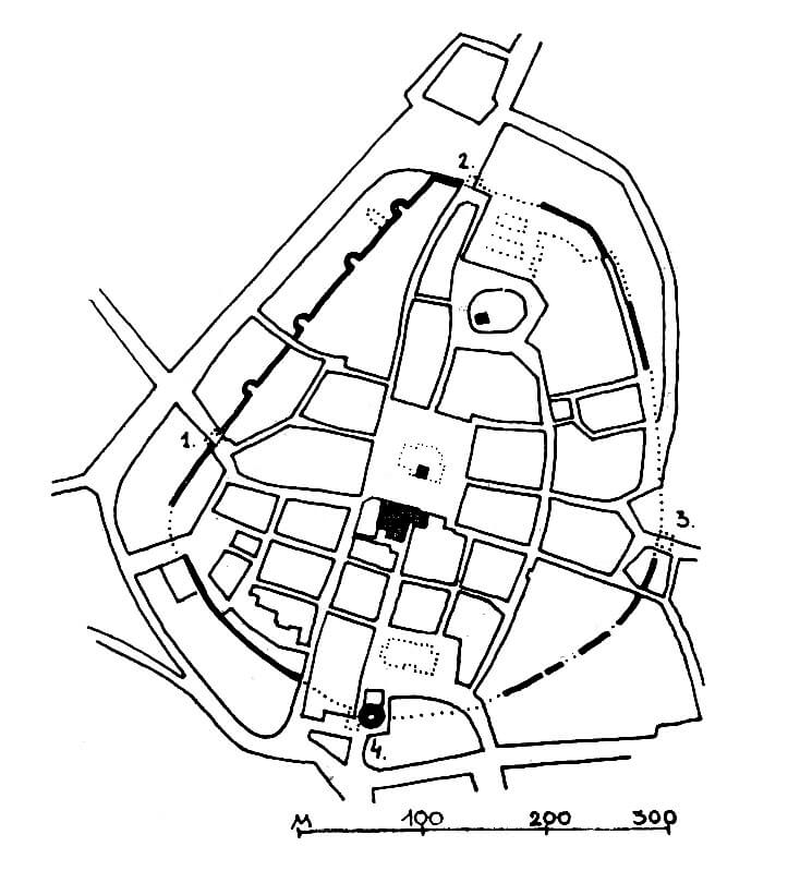
plan of Lubań according to M.Przyłęcki: 1 – Zgorzelec Gate, 2 – Nowogrodziecka Gate, 3 – Nicholas Gate, 4 – Bracka Gate
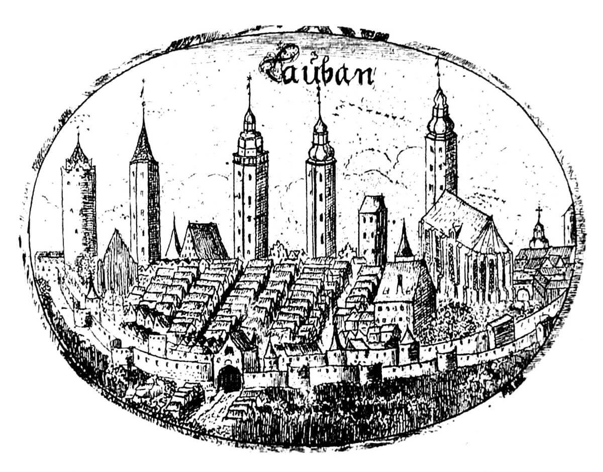
Lubań on copperplate from 1691 (Holy Trinity church on the right)
History
Lubań in the early Middle Ages was a Slavic settlement located on the trade route at the ferry across the Kwisa River, at the intersection of roads leading from Silesia to the Bohemia, Lusatia and Meissen.The town was located under the Magdeburg Law before 1268, which initiated the intensive development of Lubań (Lauben), which was then fortified with wood and earth ramparts. The erection of stone defensive walls began either at the beginning of the 14th century or around 1318, when Waldemar, Margrave of Brandenburg, Lord of Lower and Upper Lusatia, was to initiate construction works.
Originally, only one line of defensive walls was built. It is difficult to say exactly when the second ring of fortifications was built. It could have happened both in the fourteenth century and in the first half of the next century. In the second half of the 15th century, two of the gates were reinforced with foregates, and in the 16th century, the outer perimeter was reinforced with half-round bastions. Efforts were made to keep the walls in good condition at that time. The town law prohibited the storage of dung, setting up pigsties, henhouses or stables in their area. The guilds were responsible for defense and renovation, hence the names of the towers were most often derived from the names of guilds. In the second half of the 17th century, due to the Turkish threat, most of the outer bastions were rebuilt or new ones were built in their place.
The fortifications of Lubań had the first serious test during the Hussite wars. In 1427, Czech troops approached the town and on the same day stormed the fortifications in the south-west section several times. They captured one tower and made a breach in the wall, but eventually they had to withdraw. On the next day, the townspeople made an armed trip to the opponents’ camp at Kapliczna Mountain, but they had to retreat, and the Hussites chasing them broke into the town. Another attack took place in 1431. At that time, the focus was on the defense of the monastery complex and the Bracka Gate, but after undermining the gate tower in two places, the townspeople capitulated.
The next military operations took place during the Thirty Years’ War. Medieval fortifications were already outdated then, although they had not yet lost all defensive values. Moreover, in 1627 they were renovated at the initiative of the city council. In 1632, the Saxon colonel Albrecht von Kalckstein ordered the bridges in front of the gates to be destroyed, the Bracka and Nowogrodziecka gates to be bricked up and the moat to be filled with water. For a change, the Swedish army tried twice: in 1639 and 1641 to dismantle the fortifications in order to prevent the future defense of the town. The first time, however, the mayor managed to bribe a Swedish officer, and the second time, the demolition work was stopped before it reached considerable size.
In the 18th century, during the Seven Years’ War, the town fortifications were completely obsolete, they only allowed the control of people, animals and goods coming to Lubań. In the area between the wall, gardens were established, and warehouses were installed in the towers. In the 19th century, medieval fortifications and narrow entrances became an obstacle to the spatial development of the town. In 1832, the fortifications of the Mikołajska Gate were demolished, and four years later the barbican of the Bracka Gate was removed. At the end of the 1850s, the fortifications of the Nowogrodziecka Gate were pulled down. Then the demolition of defensive walls, towers and bastions also began than.
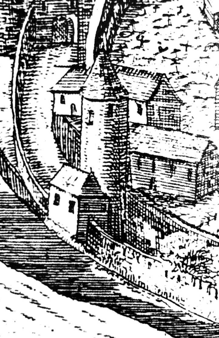
double line of Lubań fortifications on a fragment of the veduta from 1714
double line of Lubań fortifications on a fragment of the veduta from 1714
Architecture
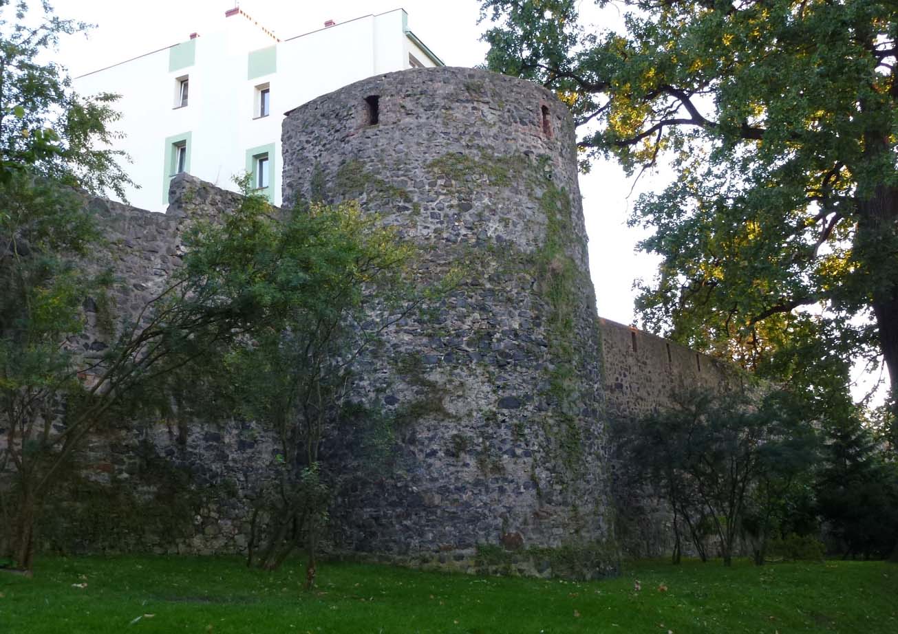
The fortifications of Lubań were given an oval shape, adjacent in the south to the higher terrain, which adversely affected the defense of the entire town. The circular outline was influenced by the shoreline of Siekierka, the slope of the area, the nature of the original settlement and the shape of the earlier, wooden and earth defenses. The length of the inner line of walls, made of basalt, was about 1400 meters. They were about 8 meters high and about 2.5 meters thick at the ground level. They were topped with a breastwork with numerous arrowslits and a roofed defensive wall-walk, although initially the breastwork could only consist of a battlement, and the roof and arrowslits could be created during the development of firearms. The younger, outer ring of fortifications was about 3.5 meters high and just over 1 meter thick. The distance between the two lines of the walls was about 10 – 15 meters.
The higher, inner line of the fortifications was reinforced by 17 towers (it is not known whether they were all original, medieval), spaced approximately every 30 – 60 meters, so at distances usually allowing for an effective shot. Most of them had semicircular forms, they were protruding in front of the outer face of the wall, most often also higher than the crowns of the defensive wall, but it happened that some did not exceed its upper edge. At least four of them were distinguished by their considerable height: one between the Bracka and Mikołajska gates, and three in the south-western section. The outer line of fortifications was reinforced in the 16th century with 15 towers (rebuilt in the second half of the 17th century) open from the zwinger side, with heights equal to the level of the defensive wall. Only one was more massive, two-story, located between the Zgorzelec and Nowogrodziecka gates.
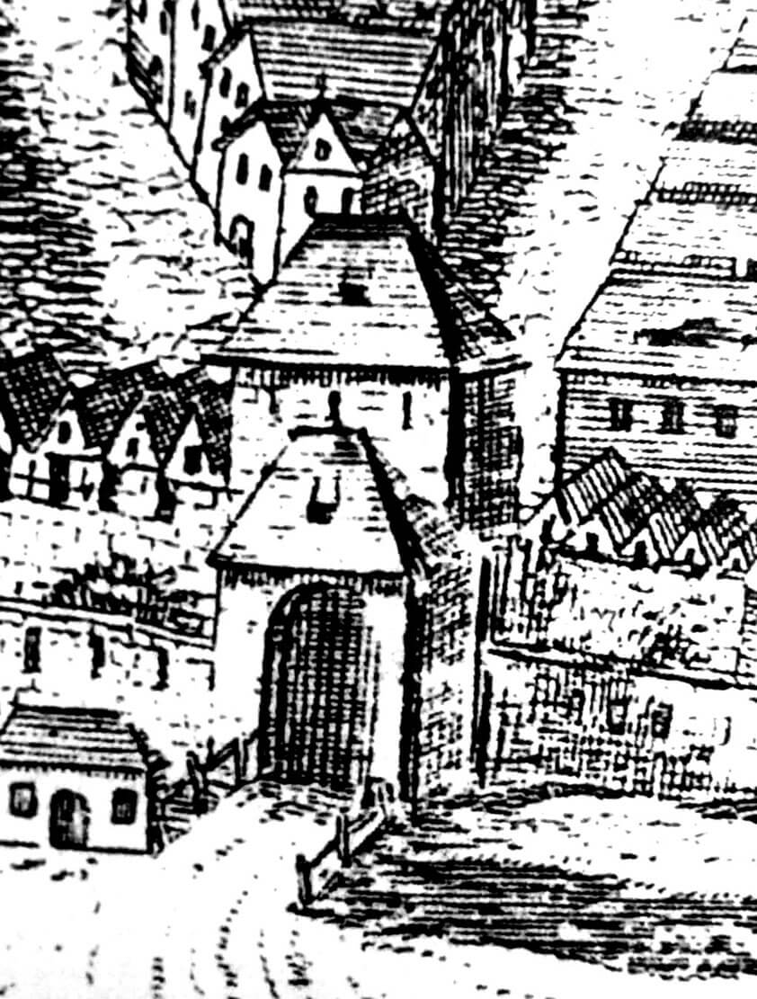
Four gates led to the town: Bracka on the southern side, Zgorzelecka on the west, Nowogrodziecka on the north and Mikołajska on the east. Bracka and Nowogrodziecka, probably in the second half of the 15th century, were equipped with barbicans. The Mikołajska, Nowogrodziecka and Zgorzelecka gates were embedded in four-sided gate towers and preceded in the zwinger area with foregates in the form of a low gatehouses, protruding in front of the perimeter of the outer wall.
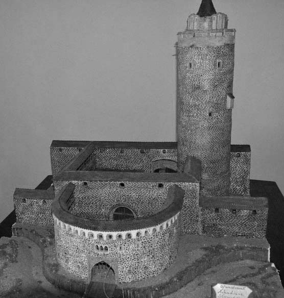
reconstruction of the Bracka Gate along with the Bracka Tower
Nicholas (Mikołajska) Gate on a fragment of the veduta from 1714
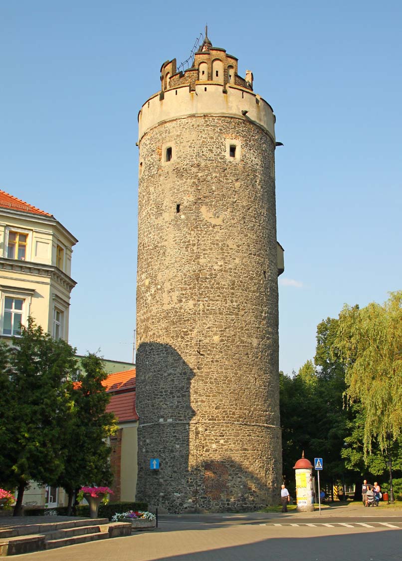
The defense of the Bracka Gate and the Franciscan monastery located in its immediate vicinity (after which it received its name) was strengthened by a massive cylindrical tower. As the only defensive structure in Lubań, it could constitute an independent point of resistance. It also performed an observation function and was of great prestige. It was built of basalt stone and divided into eight floors, 45 meters high. The thickness of the walls up to the fifth floor was about 3 meters, while at the level of the upper floors, the thickness of the walls decreased to about 2.5 meters. Originally, the entrance to the tower was located on the town side at the height of the second floor. The next storey was at the same height as the wall-walk of the defensive wall adjacent to the tower. Only above it were the first loop holes, and a latrine located at the height of the fifth floor. There was a room for the guards above. All the partitions between the floors, except for the last one, the highest one, were of a wooden structure. The tower was crowned with two breastworks covered with battlements and a pointed roof. The battlements of the first defensive gallery were about 2 meters high, while the staggered battlements of the highest porch were 1 to 3 meters high.
The Bracka Tower was located in the line of the main defensive perimeter, and additionally connected with the transverse wall crossing the zwinger. Two such walls in the zwinger area formed a foregate in front of the main gate, then preceded by a semicircular barbican.
The town had two moats. The first, about 15 meters wide and about 5 meters deep, ran around Lubań directly in front of the lower, outer line of the defensive walls. In turn, the second, in the form of a dry ditch, was located in the zwinger area. The outer moat was not irrigated along its entire perimeter, but only on the section between the Nowogrodziecka, Zgorzelecka and Mikołajska gates, where the water inflow was provided by the Siekierka river through the locks. In the remaining sections, flooding the moat was impossible due to the terrain situated too high in relation to the river.
Current state
In Lubań, significant fragments of the defensive walls have survived to this day: on the north-west side (best visible at Podwale Street), three towers, two of which are significantly lowered, and the Bracka Tower, once an element of the defense of the Bracka Gate.The tower is open to visitors from Tuesday to Sunday.
Bracka Tower, photo: Wikimedia Commons
inner defensive wall of Lubań with a tower of incomplete height
inner defensive wall with a full-height tower, photo Polek, flickriver.com
bibliography:
Pilch J., Leksykon zabytków architektury Dolnego Śląska, Warszawa 2005.
Przyłęcki M., Miejskie fortyfikacje średniowieczne na Dolnym Śląsku. Ochrona, konserwacja i ekspozycja 1850 – 1980, Warszawa 1987.
Przyłęcki M., Mury obronne miast Dolnego Śląska, Wrocław 1970.
Tekiela Ł., Mury obronne. Dom Solny, Lubań 2014.