
History
Established in 1335, Kazimierz was to protect the capital, that is Kraków, from the south. Its defensive walls were built around the mid-fourteenth century. In addition to the defensive function, they also played the role of a flood dam for low-lying Kazimierz. The period of building the walls took place during the erection of many city buildings and churches in the still young city. The initiator and founder of the facility was probably king Casimir the Great, while the maintenance of ready-made fortifications burdens the town coffers.
Casimir‘s fortifications were modernized, probably on the model of Kraków. Already in 1422, the moats were adjusted. King Władysław Jagiełło admonished on this occasion the necessity of strengthening and supplementing the fortifications. The greatest intensity of renovation works fell on the first half of the 16th century. In 1575, due to the threat of the Tatar invasion, the mending, securing and arming of the gates and walls continued. Judging from the diverse forms of preserved relics of the defense walls, works related to their modernization were undertaken several times during the sixteenth and seventeenth centuries, including at that time, the Wieliczka Gate received a barbican.
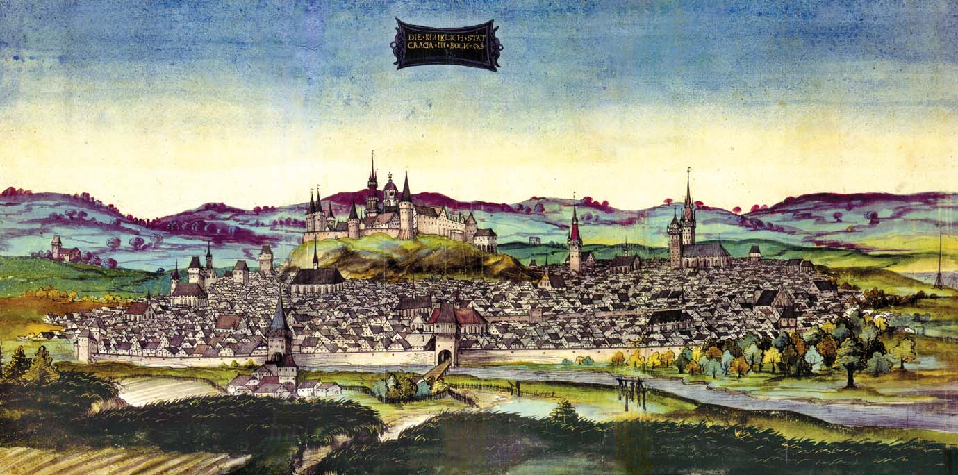
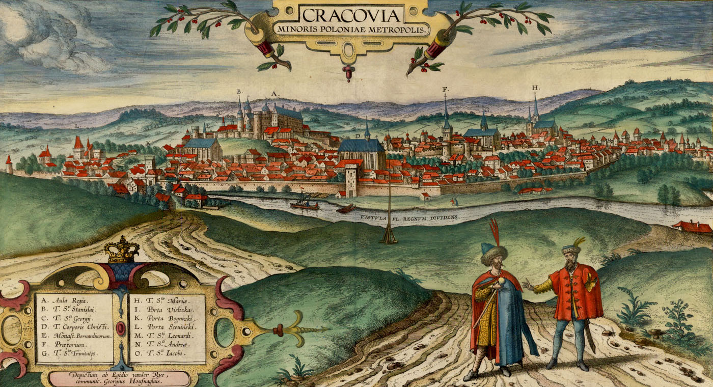
During the Swedish war in 1655-1657, fortifications were destroyed. Further damages were caused by the flood, which destroyed the section of the walls from the west. They were rebuilt, but at the turn of the eighteenth and nineteenth centuries were again in a very bad condition, which is confirmed by iconographic messages. They soon shared the fate of the Kraków fortifications, succumbing to the demolition during the first Austrian partition and the Free City of Kraków in the nineteenth century.
Architecture
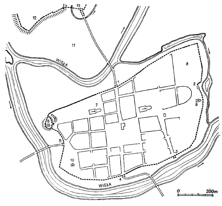
The circumference of the defensive walls marked the form of an irregular quadrilateral close to a trapezium. Irregularities of the outline were caused by the course of the Vistula and swamps surrounding the city. The area of the town within the walls was 45 ha, and the length of the fortification line was 2850 meters. The wall was erected from limestone on the lime mortar. In Kazimierz between the city buildings and the walls there was an unbuilt space, slowly forming the form of a underwall street. However, in the 16th century, the Old Synagogue and the extended Augustinian complex were joined to the walls. The general liquidation of a free lane belt took place in the 17th century.
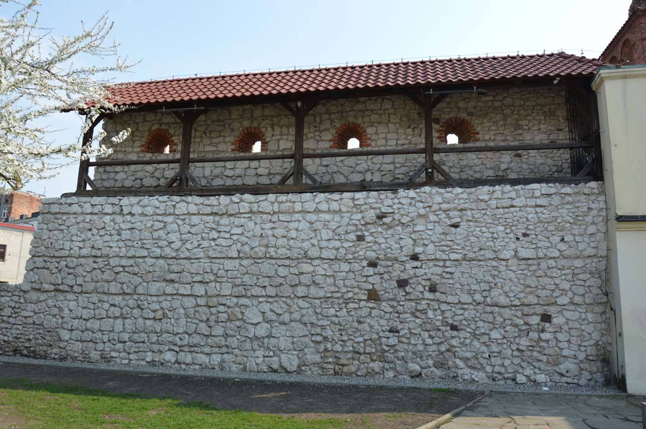
The defensive wall was built of stone and topped with a battlement with a sidewalk of defenders, placed from the side of the city on the wall’s offset. It was modeled on the Kraków wall, but it had smaller dimensions. The thickness of the wall is 1,5-1,7 meters. The original height is unknown, it can be estimated at 7 meters including battlement. A certain simplification in relation to Kraków, consisted in the resignation of arrowslits in battlement’s merlons. The width of the defenders walkway was 85-110 cm and basically did not require widening with wooden bridges.
Originally, Kazimierz probably did not have any towers. There is a relic of a rectangular tower adjacent to the Augustinian complex in the northern part of the region, moreover, according to iconographic sources, there were corner towers in both eastern corners and in the south-west. However, their cylindrical form seems to indicate that they were added to the wall at a later time.
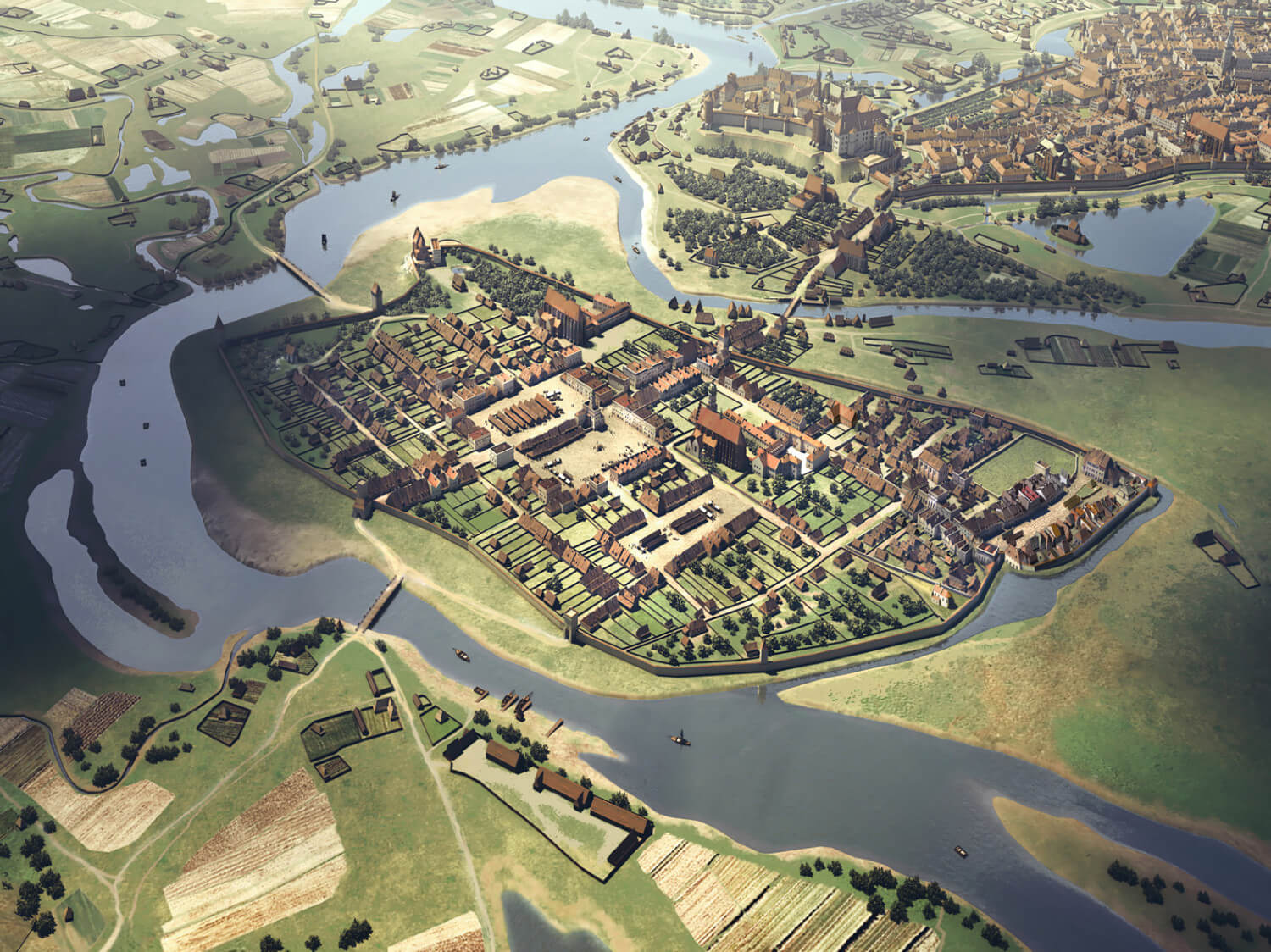
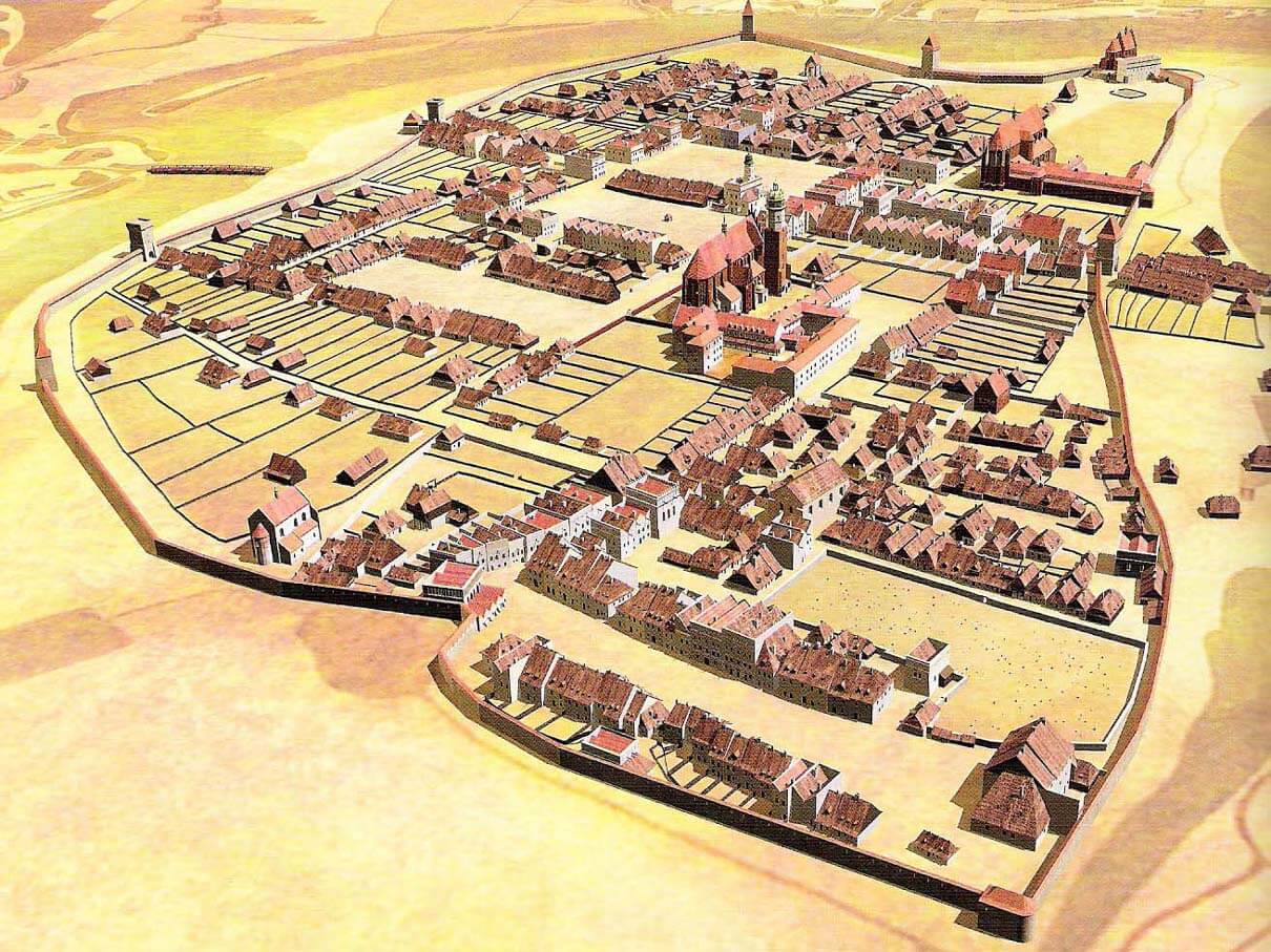
In its original appearance, Kazimierz had five gates: Clay (Kraków) from the north and Wielicka (Salt) from the south, lying on the main thoroughfare across the town. To the east of this route was the Bochnia Gate, constituting the second southern outlet. To the west was the Skawina Gate (Saint Stanislaus), and to the east – Cattle Gate. All gates were certified at the end of the fourteenth century. The Cattle Gate led to the meadows constituting a remote part of the Vistula island and served for the cattle drive. After mentioning it at the end of the 14th century, it did not appear in any records. Probably it was liquidated in the fifteenth century during the modernization of the fortifications. Other gates were located in low, single gate towers protruding from the defensive wall. Their crowns are unknown. They were equipped with drawbridges, which is confirmed by the iconographic message. In the 15th and 16th centuries, the Bochnia, Skawina and Clay gates were raised, with the latter being particularly rich crowning. Also, its lower part was rebuilt, introducing two semicircle openings: crossing and pedestrian. The Wieliczka Gate was treated differently, to which the side gate was set to the west, while the gate tower remained quite low. This gate, lying on the most endangered direction, was also given a foregate, and then a barbican. The ground floors of the gates have also been strengthened by thickening the walls.
The outer belt of defense from the north and east was a moat, separating the city from the further part of the island. It was created in the first phase of the construction of fortifications, because the mention of it dates back to the fourteenth century. The remaining sides of the city did not have any additional external reinforcements, because the line of the defensive walls ran close to the river bank and there were bridges almost directly in front of the gates.
Current state
The best-preserved fragment of Kazimierz’s defensive walls, not damaged by alterations, is located in the southern part of the fortifications, east of Kraków street. In the western part of the northern side of the city, the longest section is located, preserved on the area of about 300 meters between Skałka and the Augustinian complex. On the whole length, it is bricked up. In the eastern part of the northern part of the city, a fragment of the wall to the full height has been preserved at the Kupa synagogue. Finally, a much larger fragment, but largely reconstructed, survived at the Old Synagogue. It runs on a concave arch, made up of short, straight sections, with pronounced bends in the plan. The upper part was reconstructed in the form of a three-meter-high battlement with a roof protecting the defenders sidewalk.


bibliography:
Marek M., Cracovia 3d. Rekonstrukcje cyfrowe historycznej zabudowy Krakowa, Kraków 2013.
Widawski J., Miejskie mury obronne w państwie polskim do początku XV wieku, Warszawa 1973.