
History
The first Teutonic Knights castle in Kowalewo was built around 1231, after the order took over the local stronghold, recorded in the document granting it to Bishop Christian by Prince Konrad of Mazovia in 1222 (“quondam castrum Kovalewo”). Most likely, the oldest Teutonic building was a wooden and earth structure, built after the adaptation of an older stronghold. Despite this, it must have had significant defensive values, because in the years 1262 and 1269–1273 it successfully defended against the raids of the Lithuanians, Barts and Yotvingians. During the fighting of 1270, the Teutonic brother Arnold Kropf was to kill the leader of the Prussians, Diwan, and the castle was to be defended only by three brothers and a few men-at-arms.
Between 1272 and 1275, Kowalewo became the seat of a commander. The first known by name was a certain Rudolf, recorded in 1278, after whom the office was taken over by the above-mentioned Arnold Kropf. Moreover, in 1275 the Teutonic Knights granted the settlement near the castle town charter, but after the destruction of Kowalewo and the first castle by the Tatars in 1286, another privilege under Chełmno law was probably made at the end of the 13th century. It was probably during this period that the construction of a brick castle was started, located in a new place. Construction works probably began in the times of Grand Master Gottfried Hohenlohe, in office between 1297 and 1303. The same construction workshop was employed to build the castle and the town church (similar brick sizes, same shaped bricks, blendes). The works were carried out in the first quarter of the 14th century and had to be advanced or even completed in 1330, when during the Polish-Teutonic war, the castle was besieged by Polish knights under the command of Władysław the Elbow-high. Due to the lack of siege equipment and due to strong fortifications, it was not captured at that time.
At the end of the 14th century, information about the castle’s kitchen, bakery, locker room, infirmary, cellars and attics were recorded, in which, among others, wine, mead, beer, dishes, tablecloths and towels were stored. In 1411, an armoury, a coach house, a cattle corral and a storehouse for agricultural equipment were also mentioned. In subsequent inspection surveys from 1416-1446, the church with liturgical equipment was mentioned, and in 1421 the vogts cellar, malt house, brewhouse, bakery and the building where the flour was stored were listed. From the preserved castle inventory from 1436, it is known in turn that on one of the outer wards there was, among others, forge, powder magazine, granaries, pigsties, cowsheds, crossbow workshop, stables and vineyard.
In 1410, during the Polish-Teutonic war, the castle in Kowalewo was occupied by the knights Nicholas von Pfeilsdorf (Mikołaj of Pilewice) and Hans Polcke (Jan of Pułków). Then, King Władysław Jagiełło handed it over to the Crown Vice-Chancellor Mikołaj Trąba, but in the same year Kowalewo was recaptured by the Teutonic troops of the Balga commander. He planned further offensive actions, but it failed due to the reluctance of the knechts and foreign knights to invade the Dobrzyń Land. Another Polish-Teutonic conflict in 1414 devastated the lands of the commandery. In 1422, during the Golub War, the Teutonic Knights preventively burned the town and retreated to the castle, which was besieged by Polish troops. Despite the shelling of the commandry house and the burning of the outer bailey, the castle remained unconquered. Kowalewo was captured only during the Thirteen Years’ War, when one of the castle wings burned down during the fighting. Pursuant to the Second Peace of Toruń in 1466, Kowalewo became part of Poland. It was chosen as the seat of starosts and the site of municipal courts in the Chełmno Voivodeship.
In the 16th century, Kowalewo Castle lost its importance. At latest in the 17th century it fell into decline, and what’s more, it was partially destroyed during the Polish-Swedish war of 1655-1660. The survey from 1664 recorded a ruined tower, which was once supposed to house a prison, while a record from 1670 mentioned the still well-preserved castle chapel. The living quarters were abandoned until the 18th century at the latest. Part of the medieval bricsk was used in 1830 to build a road, while the remaining parts of the building were demolished by the Prussian authorities after the mid-19th century, in order to build an Evangelical church and a parish house.
Architecture
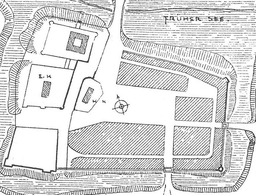
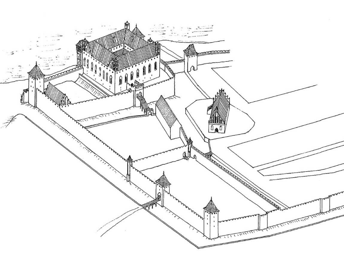
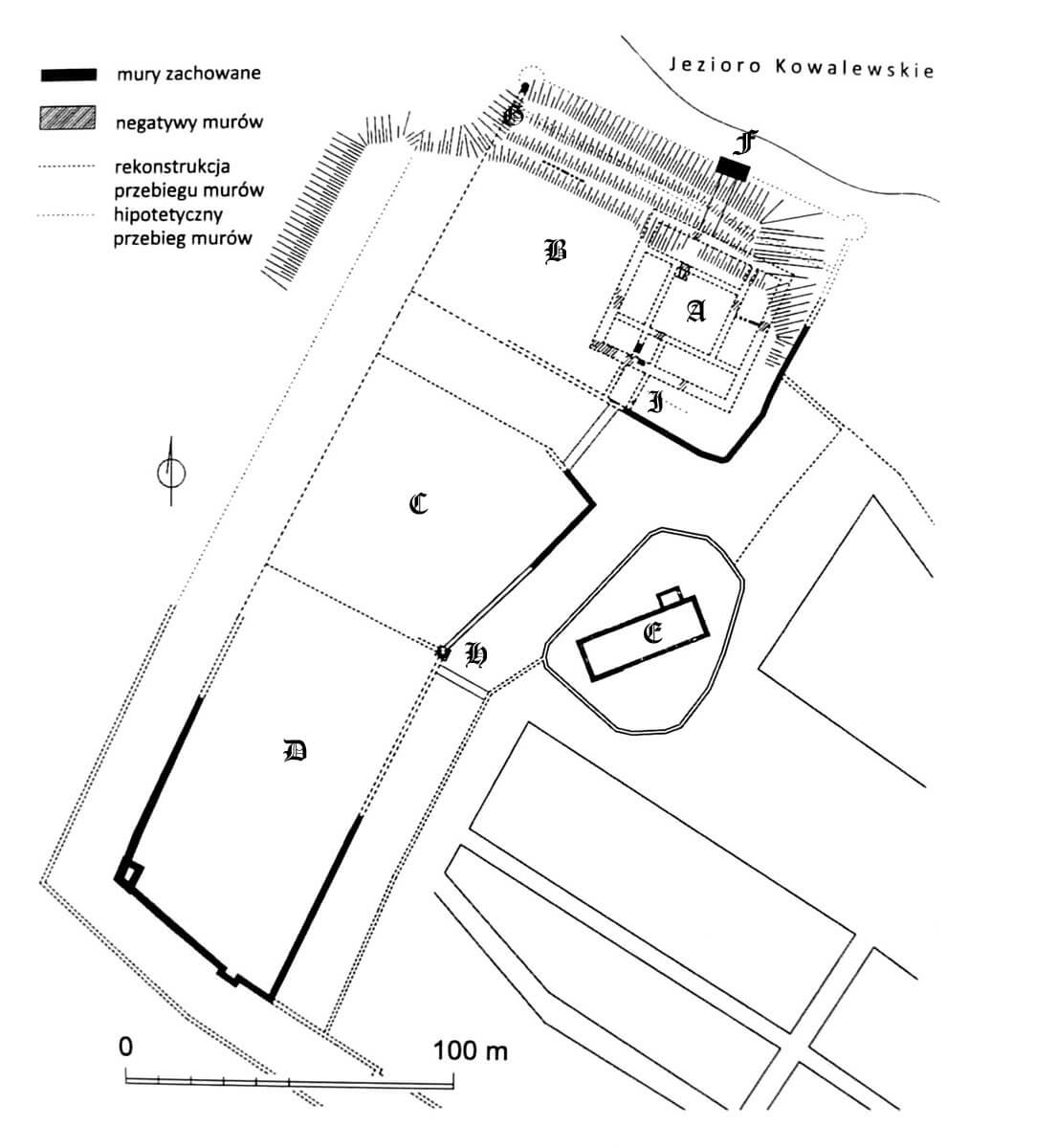
The castle was located on the high shore of the lake, next to a narrow isthmus between two lakes, on an important route from Toruń to Lubawa. The main part of the castle was adjacent to two extensive outer baileys from the south, and from the south-east to the fortified town, whose parish church was located at the middle bailey. On the western side, the upper ward had the third, smallest outer bailey. All of them were protected from the south, east and west by irrigated moats with bricked banks, about 17 meters wide. On the northern side, access to the castle was protected by the waters of the lake. The town fortifications were connected with the wall of the upper ward’s outer wall and the wall of the southern bailey. The entire complex occupied a vast area, approximately 300 meters long on the north-south line and approximately 100-150 meters wide on the east-west line. The castle walls were built of mortar-bonded stone to a height of several meters, and above them of brick laid in a Flemish bond.
The entrance to the castle complex was located in the southern bailey, where it led through a bridge over the moat. This outer bailey had the shape of an elongated rectangle with dimensions of 118 x 58 meters, the defensive walls of which were reinforced with a corner, four-sided tower on the western side and a half-tower in the southern curtain. The corner tower was not protruding from the neighboring curtains, and its sides were 7 to 9 meters long. The entrance to it was located at the first floor level and was not accessible directly from the defensive walls. Thus this building had limited defensive capabilities, especially in terms of flank fire. The rear-opened southern half-tower, which protruded towards the moat, had different features. Its asymmetrical location in the outer bailey would indicate that it was adapted to the location of town towers in the wall that was an extension of the southern curtain of the outer bailey. There was probably a gate in the western part of the southern bailey, perhaps of a tower-like form, while the second entrance certainly led from the town side. The entrance from the southern bailey to the northern bailey was only through the wall separating the two parts, because there was no moat in this section.
The central bailey had a trapezoid shape with sides ranging from 58 to 77 meters. In the southern corner, at the junction with the southern bailey, had a small octagonal tower on a four-sided base. It probably flanked the entrance from the town to the southern bailey, and from there to the middle bailey. The third, western bailey at the upper ward, with sides 42 to 52 meters long, was separated from the southern one by an irrigated moat. Initially, the upper ward was opened there, but still in the Teutonic times both parts were separated by a ditch, only 2.5 meters wide, and a thin wall. Both the western bailey and the house of the commandry were surrounded by a common perimeter of the wall, at the upper ward forming a zwinger. The north-west corner was occupied by a four-sided tower, probably identical to the prison tower recorded in early modern survey. Another similar tower could have been located symmetrically in the north-east corner of the zwinger. At the foot of the northern slope, the castle was protected by another, external defensive wall running along the lake shore. It was once believed that there were two horseshoe-shaped corner half-towers in its corners, but relics of a buttress were discovered in the north-west corner.
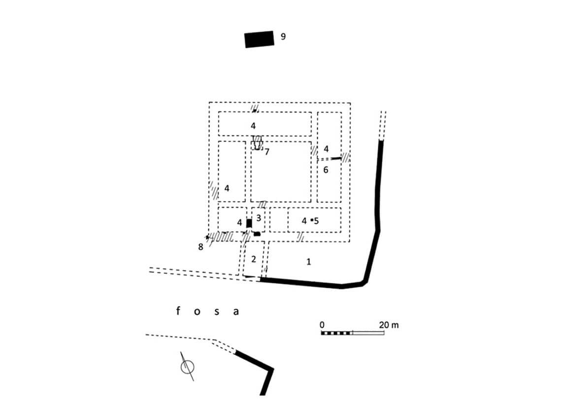
The internal buildings of the outer baileys were probably mostly wooden or half-timbered economic buildings, housing, among others, a forge, a powder magazine, a coach house, a bathhouse, granaries, pigsty, barns, sheds serving as storages, a crossbow workshop and stables, as well as a vine garden located between them. It is also known that in one of the outer baileys there was a building or a room for the order’s guests. Perhaps this function was served by a house near the southern wall of the western bailey, measuring approximately 4.5 x 10 meters, equipped with a rectangular annex from the south. Its above-ground storey was most likely made of half-timbered construction. Another building was located on the west side. It was a half-timbered structure, measuring 10-11 x 22 meters.
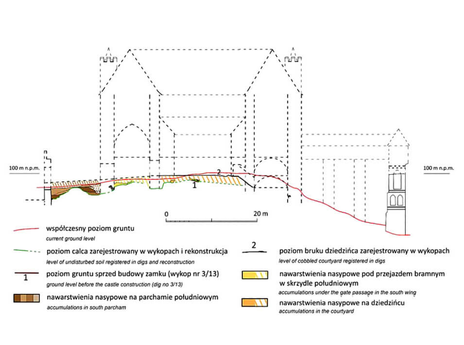
The upper ward, i.e. the house of the Teutonic Knights commandry, consisted of four wings, approximately 13 meters wide, arranged around an internal, paved courtyard measuring approximately 19 x 19 meters. It was built on a square plan with dimensions of 45 x 45 meters, made of bricks on a stone foundation. The entrance to it led from the south, from the middle bailey, through the foregate. On the north side, on the shores of the lake, there was a dansker tower (latrine), based on a massive pillar, decorated with pointed blendes and plastered friezes, measuring 4 x 8.75 meters. Its upper porch was wooden or half-timbered. It could not have had the form of brick arcades, but rather a horizontal passage, ended at the lake with a porch extended on corbels. The upper ward most likely did not have a main tower – a bergfried, nor was it equipped with corner towers, nor did it have brick cloisters, although communication from the courtyard side was probably provided by wooden porches. The corners of the wings were probably accentuated by turrets placed on the walls, similar to those once located in the castle in Golub. The external facades, like the faces of the dansker tower and the neighboring parish church, were probably decorated with blendes.
The internal layout of the upper ward was probably consistent with the typical division into storage basements, utility ground floor, residential and representative floor and attic with storage and defense functions. The main wing was the southern part of the castle, with a basement, except for the gate passage, which was not placed on the axis of the building, but moved towards the west. This was forced by the layout of the outer bailey, which was moved to the west in relation to the upper ward. The asymmetrical arrangement of the gate passage made it impossible to repeat the division of the interior from the ground floor to the first floor, as was the case in the castle in Malbork or Lochstedt. In the southern wing, on the first floor, there was a chapel, probably located in the eastern part so that the chancel was oriented towards the cardinal sides of the world. Moreover, on the first floor of the southern wing there was probably a refectory, heated by a stove, supervised by a guard at the gate. The northern and eastern wings most likely housed utility rooms, a kitchen, a brewery and a bakery, located on the ground floor. The northern wing had a basement entirely, while the eastern wing only in the northern part. It is not certain what interiors were located in the western wing. Traditionally, the ground floor must have been intended for utility purposes, while the first floor may have housed a dormitory.
Current state
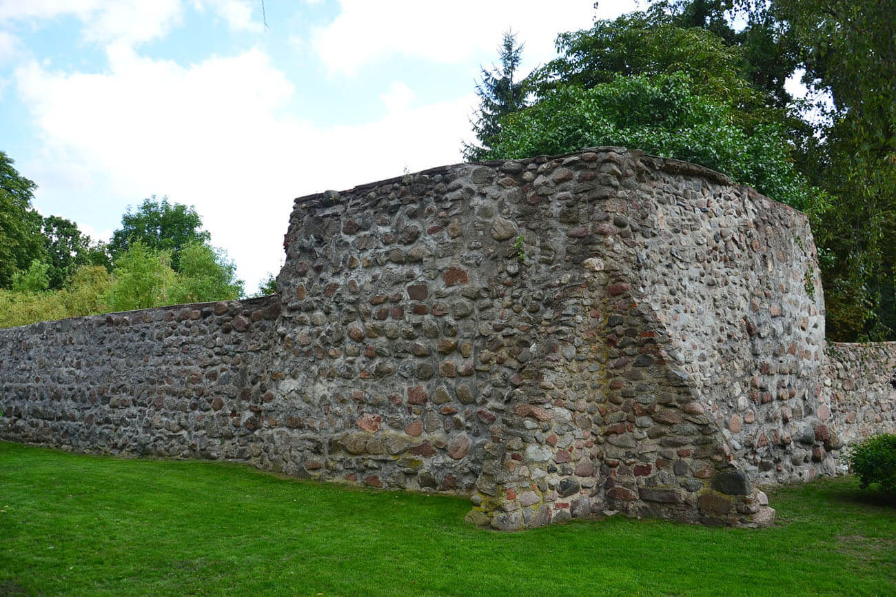
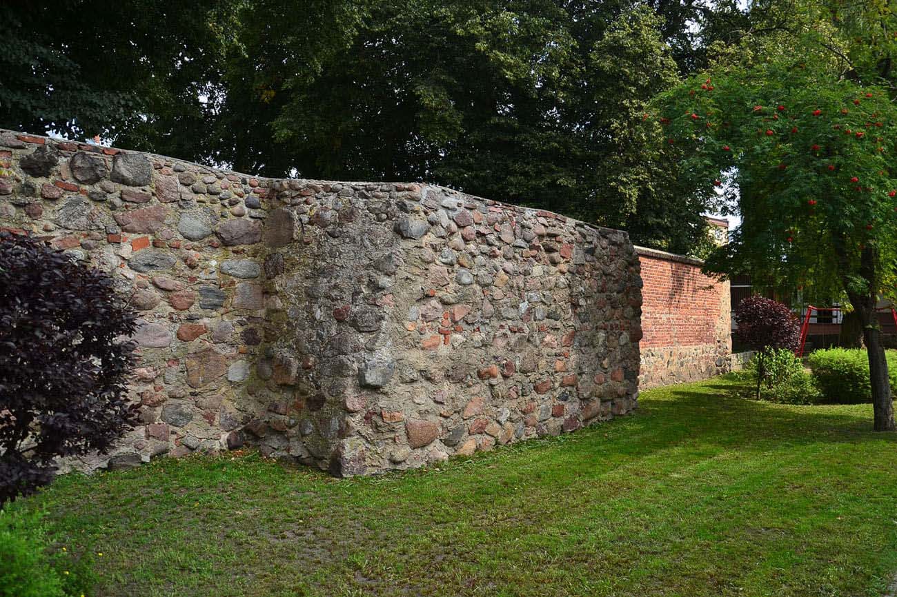
Only small fragments of the castle have survived to this day. The highest element is the pillar of the dansker, which is incomplete and currently reaches 14.5 meters in height. Fragments of the defensive walls of the outer baileys are also visible, especially the southern one with two towers, although only their lower, stone parts have survived. In the middle bailey, relics of the eastern curtain and a polygonal turret have survived, and you can also see the remains of the south-eastern part of the upper wards’s zwinger wall. Moreover, the moat between the castle and the church has been preserved quite well, and there is also a trace of the moat separating the outer bailey from the upper ward. However, no relics of the commandry house and the walls of the western bailey have survived.

bibliography:
Leksykon zamków w Polsce, red. L.Kajzer, Warszawa 2003.
Torbus T., Zamki konwentualne państwa krzyżackiego w Prusach, część II, katalog, Gdańsk 2023.
Wasik B., Budownictwo zamkowe na ziemi chełmińskiej od XIII do XV wieku, Toruń 2016.
Wasik B., Układ przestrzenny i architektura zamku w Kowalewie Pomorskim w świetle badań z lat 2013–2016, “Studia i materiały z dziedzictwa kulturowego Torunia i regionu”, tom 3, Toruń 2020.
Wasik B., Wiewióra M., Próba rekonstrukcji układu przestrzennego zamku wysokiego (domu konwentu) w Kowalewie Pomorskim na podstawie źródeł historycznych i najnowszych wyników badań archeologiczno-architektonicznych, “Wiadomości Konserwatorskie”, 45/2016.