
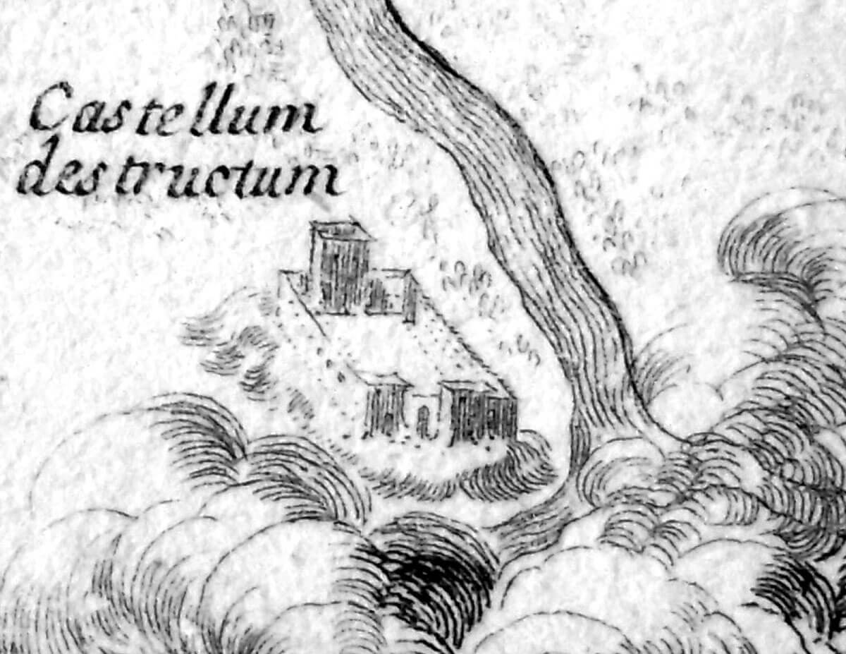
History
The castle was probably erected in the second half of the fourteenth century on the initiative of King Casimir the Great, perhaps after 1362, when the nearby town was founded. It stood on the site of an earlier tower-keep, surrounded by wooden fortifications, perhaps erected during the reign of Władysław the Elbow-high at the beginning of the 14th century or a little earlier by Wenceslaus II of Bohemia, who ruled Wielkopolska from the coronation in 1300. In the latter case, the discovered traces of a fire in the keep could be associated with Władysław’s recovery action. The tower was probably not completed at the beginning of the fourteenth century, work on its reconstruction and finishing continued only after it was included in the castle of the Casimir the Great. This, in turn, probably was not completed during the lifetime of the last Piast, and construction works dragged on into the second half of the fourteenth century, or due to the difficult political situation at that time, perhaps even at the end of that century (according to written sources, Casimir the Great himself never visited the castle in Koło).
The Koło castle protected the road leading from Wielkopolska towards Łęczyca through the Warta valley, and constituted one of the elements of the defense of the royal domain. It was the seat of starosts, the first known of which was Krystyn from Koziegłowy, also called Krzon. The first record of the castle was associated with this person. Namely, in 1383, during the internal unrest after the death of King Luois, Krystyn and several other knights were to set out from the Koło, and then plunder archbishops Turek and Grzegorzew. From 1386, Krystyn served as the castellan of Sącz, he was one of the most powerful nobles at the turn of the 14th and 15th centuries, standing loyal at the Andegawens, and then king Władysław Jagiełło. After him, the Koło was held by his son, Krystyn the younger from Koziegłowy.
The castle enjoyed its heyday in the 15th century, when it was visited by kings and the nobility of Wielkopolska used to gather there for conventions. Based on the finds, it can be concluded that intensive construction works were carried out at that time at the residential tower and inside the perimeter of the walls. Władysław Jagiełło stayed in Koło many times, especially at the end of his reign, in the 20s and 30s of the 15th century, always in the summer months. It was then that the custom of holding general conventions of the nobility of Wielkopolska in the Koło was initiated, often debating in the presence of the king. King Kazimierz Jagiellończyk, who during his long reign visited the castle at least fifteen times, was also present at the congresses at the Koło many times. During one of them, in 1476, in Koło he welcomed members of Jadwiga Jagiellon’s wedding procession returning from the Bavarian Landshut, infected with an epidemic then prevailing in Germany and Bavaria, which led to the death of many knights and royal officials.
In 1476, King Kazimierz Jagiellończyk rewarded Princess Anna Sochaczewska by giving her for life Brdów, Boleniów and Koło, in exchange for the lost Duchy of Sochaczew. After six years, the castle returned to the hands of the starosts who resided there until 1577. During the seizure of the castle by the duchess, perhaps the monarchs used the wooden court in the town, at the beginning of the 16th century rebuilt into a late-gothic brick town hall. At the same time, renovation works were carried out in the castle, because it is known that in 1506 the starost of Koło, Jarosław Sokołowski, spent 500 florins on the “restauratio castri Colo in muro et in habitationem aedificiis”. After the work was completed, Sokołowski probably lived in the castle keep with his French wife Maria de Marcellanges, with whom he may have hosted King Sigismund the Old in 1513.
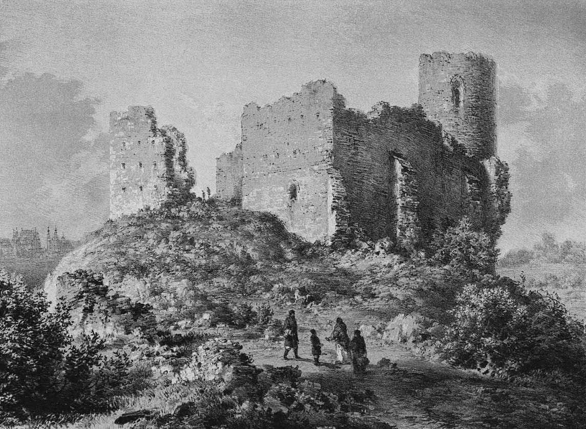
At the end of the 16th century, the castle lost its importance and began to decline. Already in 1577, it was to be abandoned by the starosts who were to move to nearby Kościelec. In 1655, it was to be finally destroyed during the Swedish invasion, although it may have been uninhabited for several dozen years. In the 18th century, the castle became the property of the Bernardines, who began to dismantle it, leading to ruin along with the destructive effects of the river (the building was partially saved by a very strong mortar, which made it difficult to obtain bricks and demolition works).
Architecture
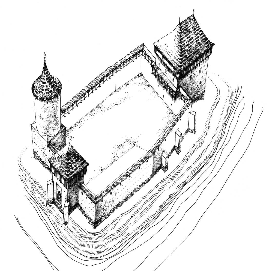
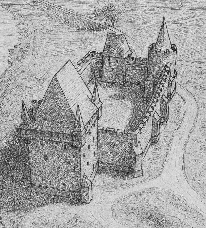
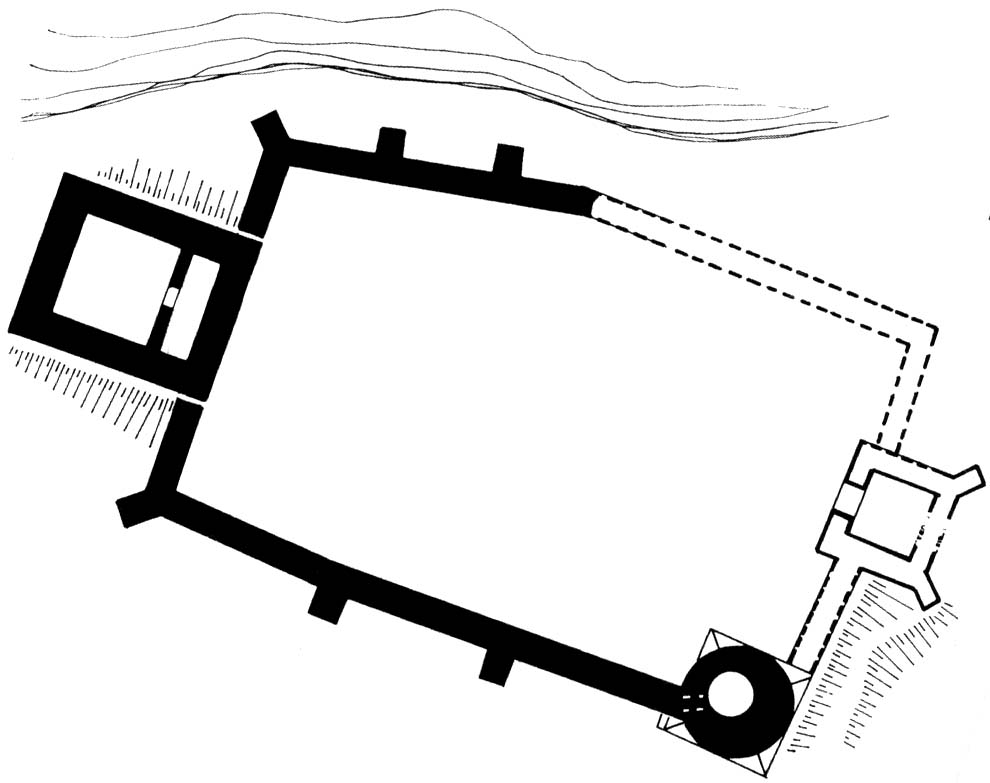
The castle was erected on a slightly elevated terrain, on the left, wet bank of the Warta River, about 1.5 kilometers from the town. This area had defensive properties, created by a wide riverbed and unregulated banks. In the Middle Ages, they were undulating, covered with sand dunes, probably forming two more distinct hills. The top of one of them was in the northern part of the courtyard, and the other in the eastern part of the courtyard. They were leveled only after the perimeter of the walls was built, so they were visible in the first period of the castle’s functioning, when it consisted of a tower house (keep) and wooden fortifications (among others, their burnt remains were used to level the courtyard area).
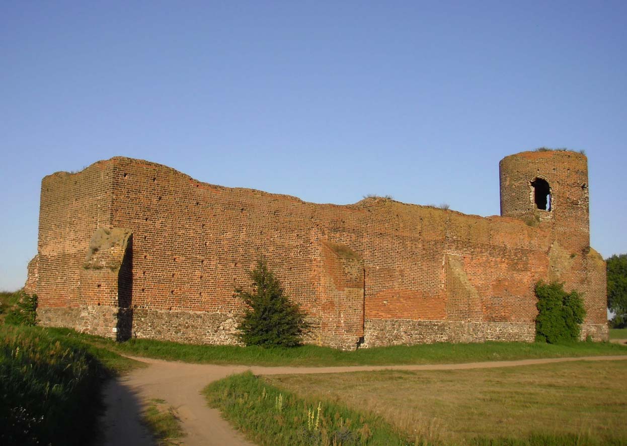
The castle from the end of the fourteenth century was a rectangular building (with a slightly bent northern curtain) with dimensions of about 30×50 meters, with the main tower (bergfried) in the southern corner, slightly protruding from the face of the defensive walls. It received a square-like base with dimensions of 7.6 x 8.1 x 8.2 x 8.6 meters, higher up into a cylindrical part with an outer diameter of 8 meters. The height was slightly more than 16-17 meters, while the thickness of the walls was about 1.9 meters. The original entrance to it was located at a height of 2 meters above the level of the defensive porch on the crown of the south-western curtain. A staircase in the wall thickness led to the upper terrace. Traces of the beams’ nests indicate that timber, flat ceilings divided the tower into two floors. It is not sure how it was topped. If you believed the iconography, it had machicolation and battlements and a conical ceramic roof. In the northern part of the outer façade, a timber latrine probably functioned.
Next to the corner tower, more than 8 meters away, in the line of the eastern curtain, there was a four-sided gatehouse with sides of 8 and 9 meters long and walls 1.8 meters thick (the interior had space of about 5 x 5 meters). It was supported from the outside by two diagonal buttresses and was significantly extended in front of the perimeter. Initially, it was believed that a gate portal led to it, but the building was in fact a structure flanking the gate passage, placed next to the curtain and probably preceded by a drawbridge. In addition, there was a small postern in the south-eastern wall. The lowest level of the building was a paved basement, approximately two meters deep from the courtyard level. It was covered with a flat ceiling, likely made of beams placed on internal offsets, in which a single entrance was created in the form of a hatch. Above this level were at least one, and most likely two or three storeys.
The courtyard of the castle was built with six wooden or half-timbered buildings and was not paved. It was surrounded by walls, which present height in the highest place reaches 10 meters. They were set on a stone pedestal, passing over 1.8 meters into a brick wall, between 1.9 and 2 meters thick. In the upper part it narrowed, eventually passing in the breastwork topped with battlements (they were 2.15 meters high). After the surviving sockets on the beams in the base of the breastwork, one can guess that the porch of the defenders has been widened with a timber part. It is not known whether the porch in the crown of the walls was roofed.
At the western curtain of the castle there was the above-mentioned older tower house or keep, built on a rectangular plan, made of blocks of sandstone and bricks, on a foundation made of erratic stones. Before the building of the castle, the tower was an independent residential and defensive structure, probably associated with wood and earth fortifications. After the construction of the castle of Casimir, it was the main residence of the rulers in the Koło. It had dimensions of 12.1 x 15.5 meters and a wall thickness of 2.5 meters. At the level of the lowest storey, it housed two rooms: larger, northern, measuring 7.2 x 6.8 meters, and smaller, southern, 6.8 x 2.3 meters, in which elements of the well were discovered. In the middle there was a 1.1 meter wide passage connecting the two chambers. The height and division of the upper floors is unknown, it can only be assumed that it had two or three floors. Assuming about 4.5 meters for each floor, this would give an impressive height of at least 15 meters, probably more with a roof truss, and maybe also with gables. Certainly, the keep was the dominant feature of the castle, surpassing even the bergfried, equipped with high-standard rooms and Gothic decorations (the interiors were heated with stoves and illuminated with multi-light windows, as indicated by a post with relics of arcades). The entrance to it with a clearance of 1.5-1.7 meters was placed on the shorter southern side, where it was most likely accessible via several stairs (due to the approximately 1.5-meter difference in the ground level).
The entire castle was originally surrounded by an irrigated moat, and relics of wooden constructions securing the building from the floodplain side were found in the outer bailey. Probably the road to the castle was covered with wood, due to the marshy terrain, already at a distance of about 15 meters from the curtains. The entire complex, excluding the older keep, was shaped as typical for the foundations of Casimir the Great in the Polish Lowlands. Its layout had many analogies to castles such as the nearby Konin, but also Inowłódz, Łęczyca or Przedecz. Built on wet, lowland terrain, mostly devoid of stone suitable for building material, they were erected of bricks on a regular plan, with a dominant corner, strong main tower, serving not only utilitarian functions, but also having a significant symbolic meaning.
Current state
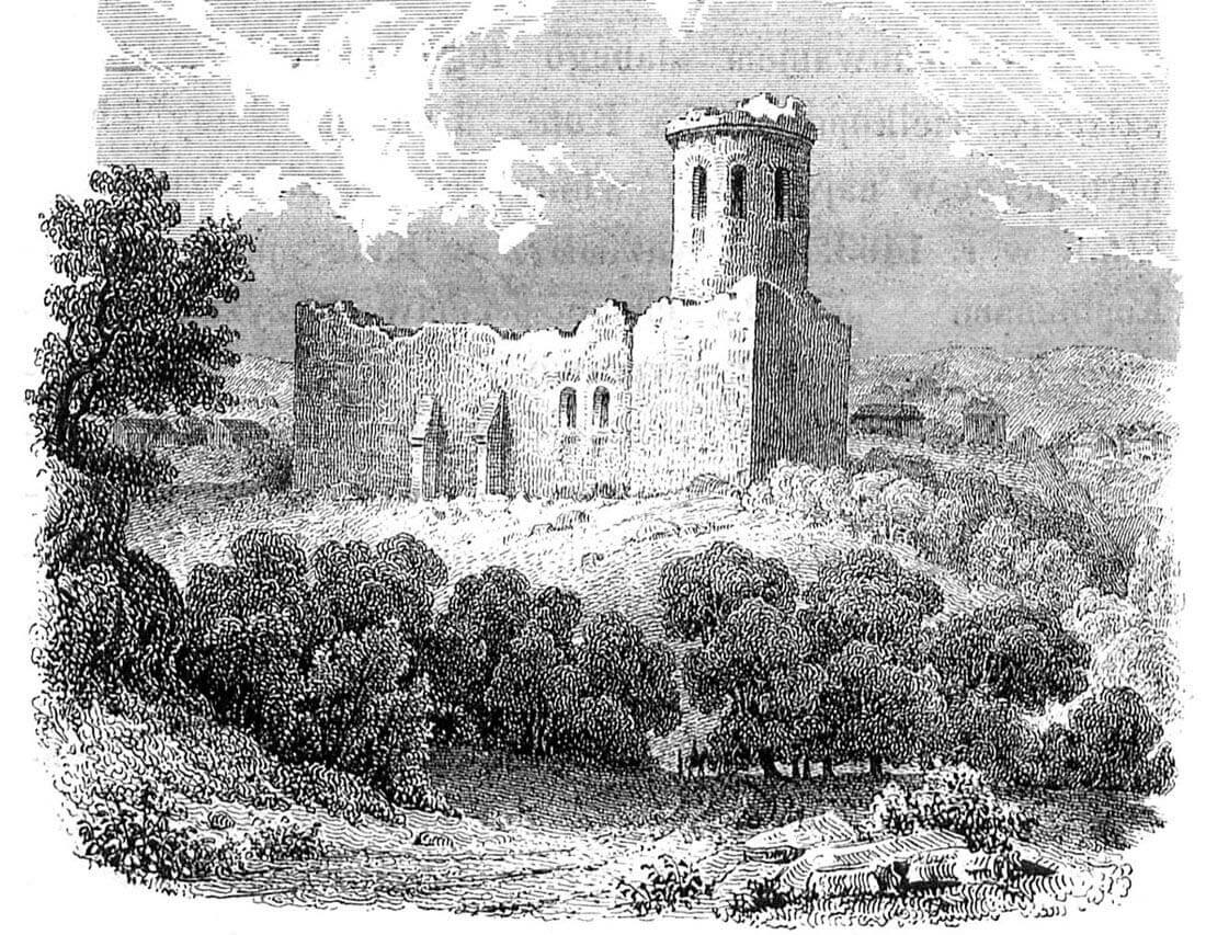
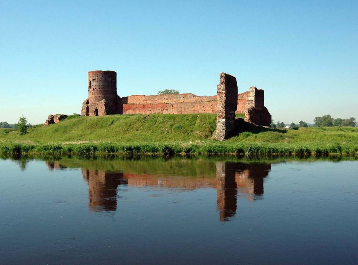
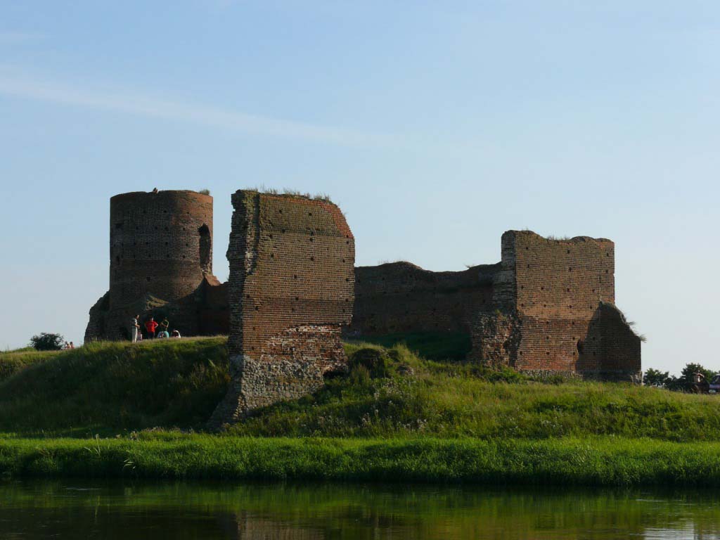
The ruins of the castle are located on a small hill in the Warta River valley and consist of the western line of the defensive wall, two sections of the northern wall, originally adjacent to the unpreserved keep, and a corner tower (bergfried), the current height of which is up to 17 meters. The eastern and south-eastern parts of the perimeter wall together with the gate almost completely disappeared, probably due to the ground sliding down the slope. The keep is known primarily from archaeological works, during which its foundations and the lowest parts of the above-ground walls were revealed. Admission to the area of the ruin is free.
bibliografia:
Architektura gotycka w Polsce, red. M. Arszyński, T. Mroczko, Warszawa 1995.
Baciński J., Zamek królewski w Kole, Koło 2005.
Lasek P., Olszacki T., Wieża mieszkalna w Kole i jej problematyka badawcza [w:] Non sensistis gladios. Studia ofiarowane Marianowi Głoskowi w 70 rocznicę urodzin, red. J.Maik, O.Ławrynowicz, P.Nowakowski, Łódź 2011.
Leksykon zamków w Polsce, red. L.Kajzer, Warszawa 2003.
Olszacki T., Zamek w Kole w świetle wyników badań archeologicznych (1977-1983) i nowych interpretacji [w:] Królewskie miasto Koło. Studia w 650 rocznicę lokacji miasta, red. I.Skierska, Koło 2012.
Olszacki T., Piaskowska B., Prarat M., Różański A., Schaaf U., The ruins of the castle in Koło in the light of the latest architectural and archaeological research, and their conservation issues, „Architectus”, 4(72), 2022.
Olszacki T., Różański A., Residential tower of the Koło castle in the light of the latest archaeological research, “Archaeologia Historica Polona”, vol. 29/2021.
Pietrzak J., Zamki i dwory obronne w dobrach państwowych prowincji wielkopolskiej, Łódź 2003.
Tomala J., Murowana architektura romańska i gotycka w Wielkopolsce, tom 2, architektura obronna, Kalisz 2011.
Wagner A., Murowane budowle obronne w Polsce X – XVII wieku, tom 1, Warszawa 2019.