
History
The castle in Kłodzko was built on the site of the early medieval hillfort named Kladsko from the tenth century, belonging to the Czech ruler Slavkov. It was of key importance in the region of the Kłodzko Valley, as it controlled the passage in the valley of the Nysa river, which ran a trade route leading from southern Europe to Pomerania. For this reason, this place has been repeatedly the subject of fights between Czech and Polish rulers.
Kłodzko was the seat from which the Kłodzko Land was managed since the eleventh century. In 1114, the claimant to the Czech throne, Soběslav, captured the stronghold and set fire to its wooden fortifications, but probably rebuilt it as the Czech ruler in 1129. Over time, at the foot of the hillfort, at the end of the 12th century, on the south and east sides formed two boroughs, the origin of the future town. At the junction of these settlements there was a marketplace. The foundation of the town Kłodzko (Kladzko, Glodzko, Glatz) connecting the two older centers, took place in the first half of the 13th century, probably shortly before 1250.
Along with the castle, most probably at the end of the 13th century, brick fortifications of the town began to be built, replacing the former earth and wooden fortifications. The source mentions confirm their extension in the fifteenth century to the outer, second ring of walls. The great defensive values of the castle and the town was confirmed by the unsuccessful attempt of conquer by the Hussites in 1428 and the failed attack of the army of Matthias Corvinus in 1470.
In 1459, the Kłodzko land became an independent county and belonged to Podebrady family. A year later, George from Podebrady approved all the privileges of the town, thanks to which Kłodzko remained loyal to him during the wars with Catholics, even when in 1467 when the Pope put an anathema on town. Thanks to George‘s efforts, after the fire of 1469, the fortifications were renovated and modernized, during which among others gates received new gatehouses.
After prolonged fighting and riots from the second half of the 15th century, Kłodzko depopulated and became impoverished. It was also influenced by numerous epidemics (among others in 1430, 1472, 1493) and subsequent fires (in 1493) and floods of Nysa (in 1454 and 1475). Probably it was not without influence to the condition of the city’s fortifications and the castle. The improvement of the situation and entry into the period of prosperity occurred in the mid-sixteenth century. Thanks to that in the years 1557-1560, the Kłodzko castle was extended by enlarging the outer ward and giving the renaissance lookout to residential parts.
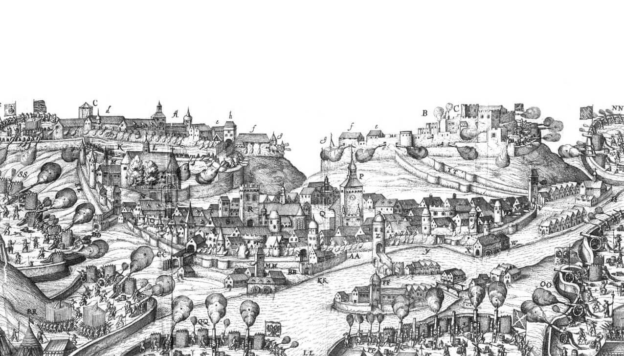
In 1622 castle was destroyed by the imperial army during the Thirty Years’ War, and at the end of the seventeenth and eighteenth centuries, the medieval castle buildings were completely rebuilt into an early modern bastion stronghold. In the 19th century, the demolition of the town walls was also begun. First, in 1810, all gates were demolished, long sections of curtains with towers, and the remaining fragments were lowered, and then in the years 1898-1891 other, larger fragments of walls were slighted.

Architecture
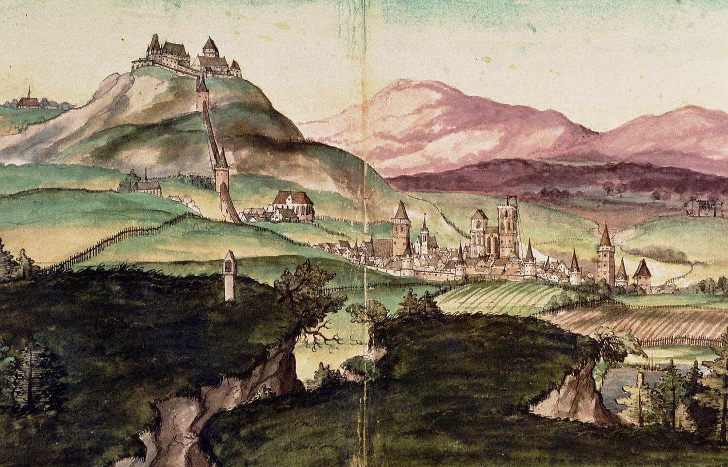
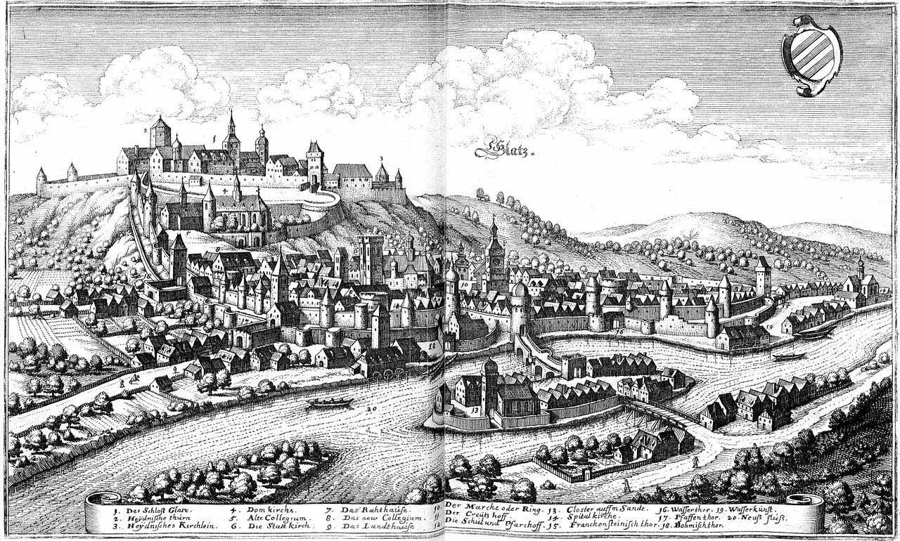
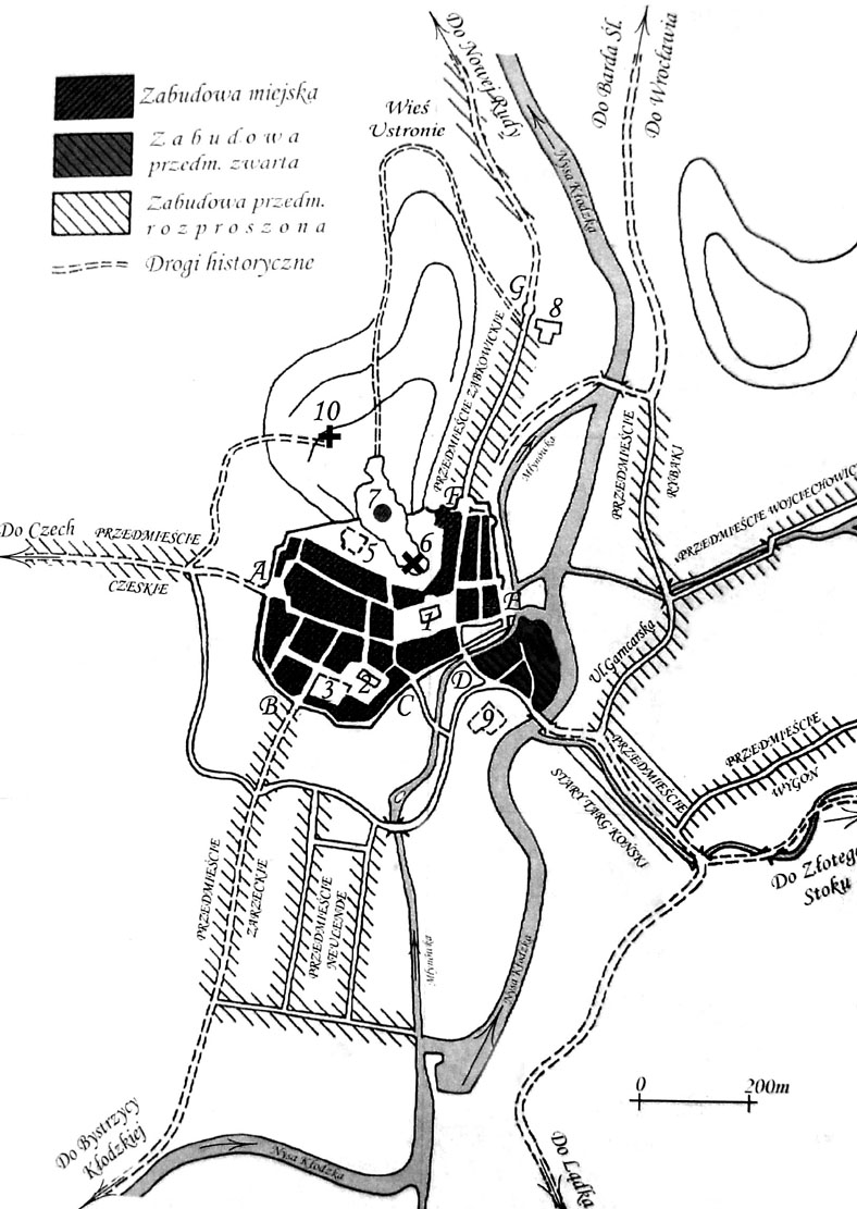
Due to the terrain, the town fortifications were erected on an irregular plan, somewhat similar to a crescent. On the eastern side, the town was bordered by the Nysa Kłodzka riverbed, or in fact the Młynówka canal, which served as a moat in the eastern section. From the north, the town partially surrounded the castle hill dominating over Kłodzko, the headland of which formed a narrowing between the greater western part and the smaller north-eastern part of the town. The town walls did not form the full perimeter, as they connected with the castle fortifications, climbing the slopes of the hill in the northern part of the complex.
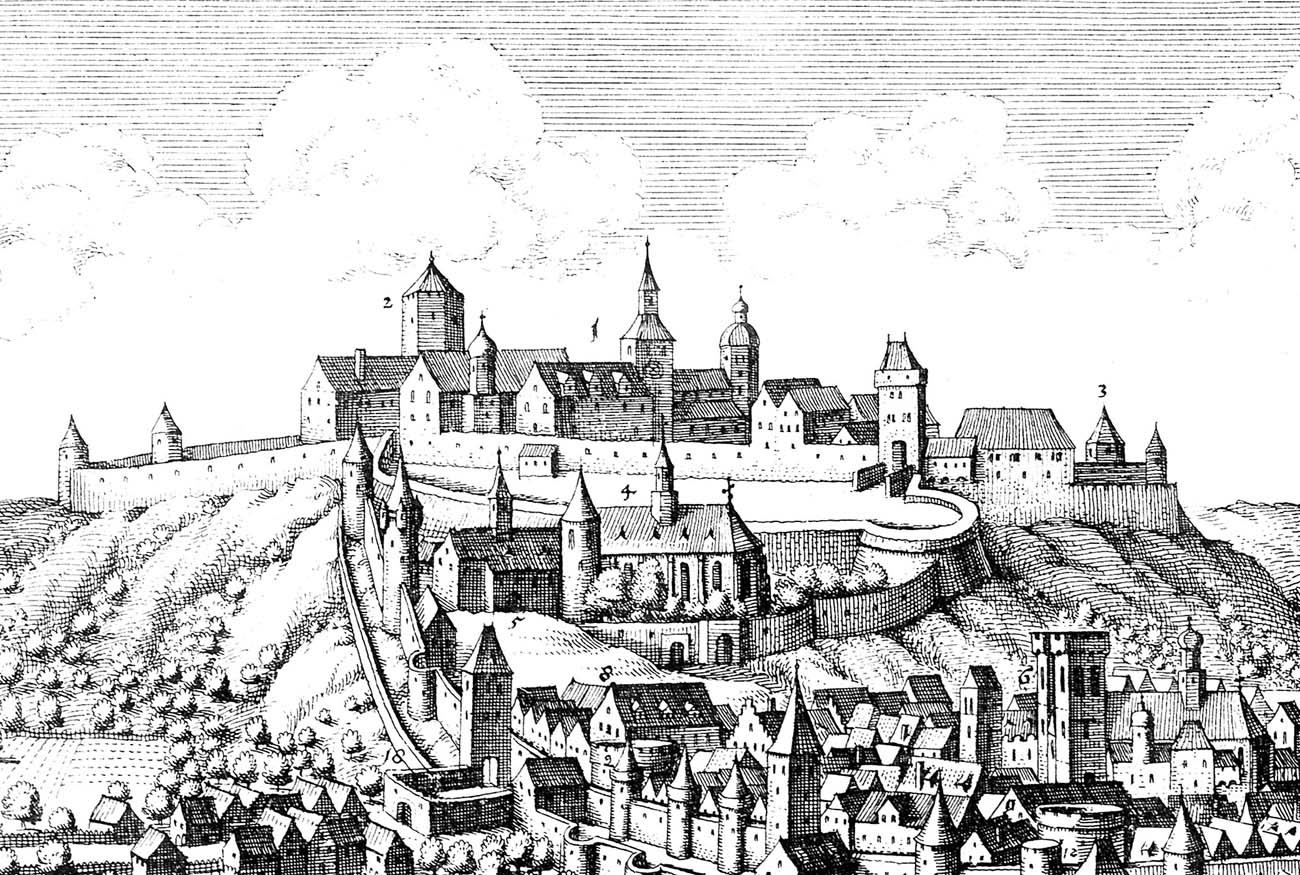
The line of the defensive wall was reinforced with half towers on a rectangular and semicircular plan. The original method of crowning of the curtains is unknown, it is only known that at the end of the Middle Ages they had a covered wall-walk with a parapet pierced by arrowslits. The towers were higher than the curtains by one and some by two storeys. In the second half of the fifteenth century, they were crowned with pyramidal helmets, and in front of them a second perimeter of the lower wall was created, equipped with semicircular bastions.
The Czech Gate from the west, the Green Gate (Zarzecka) from the south-west and the Ząbkowicka Gate (Hospital Gate) from the north-east, as well as the Water Postern and Bath Gate led to the town. In addition, from the opposite bank of the river, you could get to Kłodzko through the Lower Gate on the Sand Island, and then the Upper Gate (Bridge Gate), located behind the St. John Bridge placed over the Młynówka. The gates were placed in towers with passages in the ground floor.
According to the Czech chronicler Cosmas of Prague at the turn of the 11th and 12th century, there was a stone palas on the castle hill. The remaining buildings and fortifications were probably wooden and earth. Later in the Middle Ages, the castle was an irregular defensive complex, closely connected to the town’s fortifications, with numerous secular and sacred buildings, courtyards and accompanying buildings. It is known that it consisted of an upper and a lower part (an outer bailey), separated by a wall and a moat. The entrance to the castle was placed in the massive four-sided gate tower visible in the drawing of M.Merian. The upper part reportedly had three courtyards. In the last quarter of the fifteenth century, on one of them a two-aisle Green Hall was erected, decorated with paintings with floral motifs, used on the occasion of important audiences and ceremonies. In the upper castle there was also a chapel, probably under the invocation of the Blessed Virgin Mary and at least two quadrilateral towers, depicted on a 16th century veduta. The main tower could have had an octagonal form.
Current state
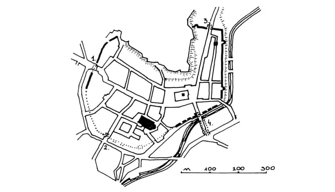
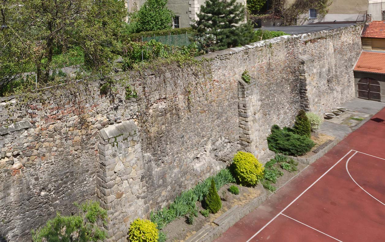
Most of the town walls of Kłodzko were demolished in the 19th and early 20th centuries. Currently, only a few fragments are at the end of Traugutt street, along Nad Kanałem street and below Łukasińskiego street, so in the north-west and north-east parts of the former defensive circuit. There are no traces left of the medieval Kłodzko Castle, it has been completely transformed into a 18th century fortress. Unfortunately, for this reason, there is no data to recreate its original appearance and one must rely only on early modern plans and vedutas from before the reconstruction.
show place of former castle on map
bibliography:
Broniewski T., Kłodzko, Warszawa 1970.
Frydrych B., Oniszczuk-Awiżeń K., Kłodzko w średniowieczu, Kłodzko 2009.
Leksykon zamków w Polsce, red. L.Kajzer, Warszawa 2003.
Przyłęcki M., Miejskie fortyfikacje średniowieczne na Dolnym Śląsku. Ochrona, konserwacja i ekspozycja 1850 – 1980, Warszawa 1987.
Przyłęcki M., Mury obronne miast Dolnego Śląska, Wrocław 1970.
Záruba F., Hrady doby přemyslovské I. Královské hrady, biskupská sídla, Chebsko, Praha 2023.