
History
In the Early Iron Age, on the edge of the Vistula River valley, a fortified settlement of the Lusatian and then Pomeranian cultures was erected. After the period of its intensive use in the 8th – 3rd century BC, there was a reduction or even disappearance of settlement, and the stronghold was covered with layers of sand. During the Migration Period, a significant number of people emigrated from the areas on the Vistula. Another, initially poor penetration in the vicinity of Kałdus took place only in the 7th / 8th century AD. Long after the original settlement had been abandoned or destroyed, in the 11th / 12th century people began to settle on the hill left by the previous inhabitants, and at the end of the 12th century a small early medieval stronghold was created. In the next century, it was transformed into a vast settlement complex including a stronghold, a craft and trade settlement and two cemeteries.
The complex in Kałdus was, next to Gdańsk, the most important settlement center in Eastern Pomerania in the early Middle Ages. Its strategic and political importance was determined by its convenient location at the intersection of the two main trade routes: the Vistula and the Ruthenian-Baltic routes. In the first half of the 11th century, there was a political center of Bolesław Chrobry and Mieszko II, at which the construction of a stone basilica also began. The function of the great sacral complex, founded on the periphery of the early Piast state, remains a mystery. The basilica was not completed, walls were raised to a height of about 1 meter, after which the construction was abandoned, probably due to the pagan rebellion after 1034.
The hillfort was destroyed in the 20s of the 13th century as a result of the Prussian invasion. After burning, Konrad Mazowiecki gave Kałdus to the missionary bishop Christian, but due to the increasing attacks of the Prussians on the Chełmno land, the prince decided in 1226 to bring the Teutonic Knights of the Order of the Hospital of the Blessed Virgin Mary. Knights were to build a watchtower in Kałdus in the 40s of the 13th century, which, however, was quickly abandoned.

Architecture
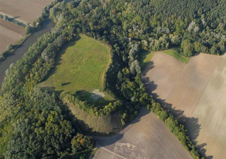
The hillfort was situated near the eastern bank of the Vistula River, on a hill similar in shape to an oval with a promontory protruding to the south-east. The area of the stronghold was located at an altitude of about 80 meters, surrounded by floodplain areas and two erosive valleys cutting the slope of the Vistula valley with flowing water. The base of the hill with its headland was about 2 ha.
The rampart of the Bronze Age hillfort had a kidney shape, adapted to the terrain, with a length at the base of 100 meters on the inside, and 140 meters on the outside. The width of the earth rampart at its base was about 50-60 meters, while its relative height was about 9-10 meters, so its crown rose to a height of 90-92 meters above sea level. The southern, eastern and western slopes of the embankment were steep, and milder in the north. A timber and earth defensive structure probably functioned on the rampart. Yet in the era of the Lusatian culture, but after the original fortifications had been burned down, the rampart was expanded in the eastern part with an embankment about 40 meters long and 5-7 meters thick, running in the north-east and north direction, which transformed the flattened crown into a ridge form. The gate to the stronghold was probably located on the south-west side, facing the river crossing.
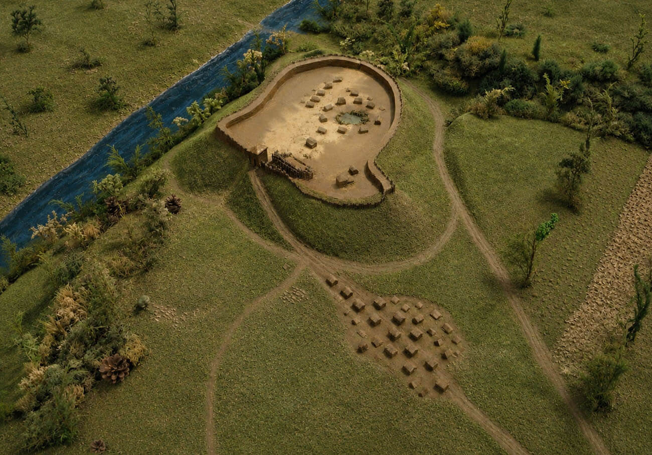
Around the turn of the 10th and 11th centuries, four-sided, semi-underground and above-ground type huts were built on the south-eastern tip of the hill and in the central part of the courtyard. Moreover, at a distance of about 300 meters, in the Vistula valley, an open settlement was established. Between the second quarter of the 11th century and the beginning of the 12th century, a two-part hillfort was formed. The so-called an internal stronghold on the headland, and the main part of the stronghold in the western and northern part of the hill, filled with similar types of log buildings. Both parts were separated by a ditch, while the smaller internal stronghold was probably associated with the elite and the hillfort comes, and therefore probably better defended. A unique element was a stone pile in a marshy depression at the foot of the hill, identified as a sacred sacrificial altar. In the southern foreground of the hillfort, a settlement was built with buildings located linearly along the base of the hill, then expanded to the form of large, fenced homesteads serving craft and trade functions. In the 12th century, new houses were built in the hillfort, also in the log construction, but the spaces between them were already filled with timber sidewalks.
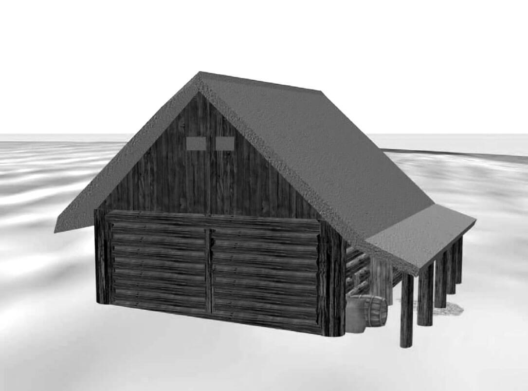
In the second half of the 12th century, the timber buildings of the hillfort burnt, and in their place new houses and numerous furnaces related to metallurgical production appeared. At the same time, the open settlement significantly expanded to about 6-7 hectares, and with the riverside part in the Vistula valley, to about 15 hectares. On the southern side of the hill, in the northern part of the settlement, which served a market and craftsman functions, it is likely that an inn with the closest economic facilities began to operate at that time. It was a building larger than the others, four-sided, with dimensions of 6.7 x 5.5 meters, erected in the post-and-plank technique. In the northern part, it had a wide entrance with a roof (arcade) along the entire length of the house, about 2.4 meters wide, supported by several timber pillars spaced approximately every 1 meter. The entrance with an arcade was located on the side of the natural slope, along the foot of the road leading from the Vistula valley to the hillfort. In the central part of the building, a short distance from the entrance, a layer of ash would indicate heating and lighting of the inn with a portable source of fire suspended above the floor or other similar structure. Perhaps there was also a hearth or stove outside the building, used to prepare meals that were then brought inside. Near the south-west corner there was a timber structure, a kind of corner bench. It was probably made, just like the whole building, in a post-and-plank technique, fixed to the wall or in the form of a chest. The building probably did not have an upper floor, but at most an attic under a gable roof.
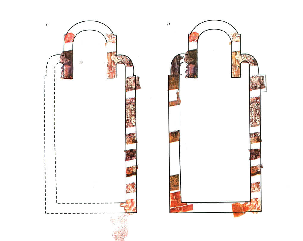
A stone basilica, orientated to the east-west line, was erected directly at the base of the hillfort. The walls of this church, preserved in some places up to a meter high, were built of unworked stone in the opus emplectum technique, bound with lime mortar. They were about 1.95 meters thick. The exceptionally large dimensions of the building, about 36-37 meters long and about 17 meters wide, can only be compared with the size of the cathedral churches existing at that time in Gniezno and Poznań. It had three aisles, three apses, including two side ones and one main, protruding towards the east, and a small annex (4.3.5 meters) at the southern aisle, ended with a semicircular apse on the west side. Perhaps this annex served a baptismal function. Probably the basilica was never completed, because no traces of the internal divisions of the building, foundations of the pillars, remains of floors and architectural details have been found.
Current state
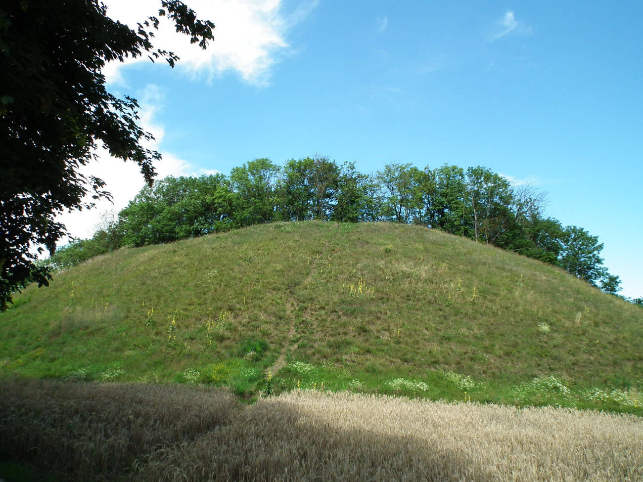
At present, the hill is protected as a steppe vegetation reserve called St. Lawrence Mountain. There are no relics of buildings visible to the naked eye, but there are earth ramparts of the hillfort itself. The walls of the basilica, hidden underground, are supposed to reach a height of one meter in places.
bibliography:
Abramów J., Bienias D., Bojarski J., Chudziak W., Kowalewska B., Makowiecki D., Siemianowska E., Szczepanik P., Weinkauf M., Domniemana karczma z wczesnośredniowiecznego zespołu osadniczego w Kałdusie na Pomorzu Nadwiślańskim, “Przegląd archeologiczny”, 64/2016.
Chudziak W., Geneza wczesnoromańskiej bazyliki z Kałdusa na Pomorzu Nadwiślańskim [w:] Początki architektury monumentalnej w Polsce, red. Janiak T., Stryniak D., Gniezno 2004.
Mons Sancti Laurentii, tom 2, Wczesnośredniowieczny zespół osadniczy w Kałdusie. Studia przyrodniczo – archeologiczne, red. W.Chudziak, Toruń 2004.
Mons Sancti Laurentii, tom 8, Wczesnośredniowieczny zespół osadniczy w Kałdusie. Studia archeologiczno- paleobotaniczne, red. W.Chudziak, A.Noryśkiewicz, Toruń 2016.
Rodzińska-Chorąży T., Kilka uwag w sprawie metody prezentacji i interpretacji reliktów budowli sakralnej w Kałdusie, “Czaspismo techniczne”, zeszyt 23, rok 108, 2011.
Świechowski Z., Architektura romańska w Polsce, Warszawa 2000.