


History
In the first half of the 13th century, Gubin (Guben) was an important settlement of craftsmanship and trade, which was due to its location at the crossing of the Nysa Łużycka River, on an important route from Wielkopolska to the western regions of Lusatia and further to Germany. The development of the settlement was favored by the privilege of salt storage, recorded since 1211. In the second decade of the 13th century, on the initiative of Henry the Bearded, the town was founded, supplemented in 1235 with the privileges of the Magdeburg Law granted by Henry the Illustrious, Margrave of Meissen and Lusatia. Probably soon after the construction of the first wood and earth fortifications began.
The first information of the town fortifications, recorded in 1301 an earth rampart with a palisade and a moat preceding it. In 1311, Margrave Waldemar granted the town privileges, from which the proceeds to the town treasury were to support the construction of the defensive wall. The brick defensive perimeter was erected in the 14th century, and further expansion works were carried out in the 15th and 16th centuries. Already in 1319, it was recorded that the brick walls repulsed the attack of the Czech army of John of Luxembourg, which would indicate that the construction process was carried out extremely quickly.
In the Middle Ages, the maintenance of fortifications in good condition was the responsibility of the guilds. This was associated with large financial outlays, especially when modernizations were also planned. In these undertakings, the guilds were supported by the rulers and the town council, who usually earmarked the income from taxes and customs duties for the expansion, and also enacted various types of reliefs for those participating in construction works. In Gubin, the renovation and strengthening of the fortifications was carried out in the years 1523 – 1544 on the wave of the Turkish threat, with the main focus being on improving the defense of the gates. The moat was also deepened.
Since the Thirty Years’ War in the first half of the 17th century, Gubin’s fortifications became obsolete due to the rapid development of artillery. In the following years, the defensive walls deteriorated and began to be blocked with illegally erected residential and economic buildings. In 1676, the flood-washed tower at the Krosno Gate collapsed. At the end of the 18th century, the technical condition of the remaining parts of the fortifications was so bad that they began to be dismantled. Demolition works were also carried out in the first half of the 19th century.

Architecture
The town was founded on the eastern bank of the Nysa Łużycka River, just below the Lubsza River flowing into it, which surrounded Gubin from the north and east. The southern side, the only one not protected by a natural water barrier, was secured by a moat, filled with Lubsza waters and connected to the Nysa River. The area of the river terrace occupied by the town was also limited from the north and east by hills, about 50 meters higher, called the Gubin Hills, which made it possible to grow vines, but were unfavorable from a military point of view.
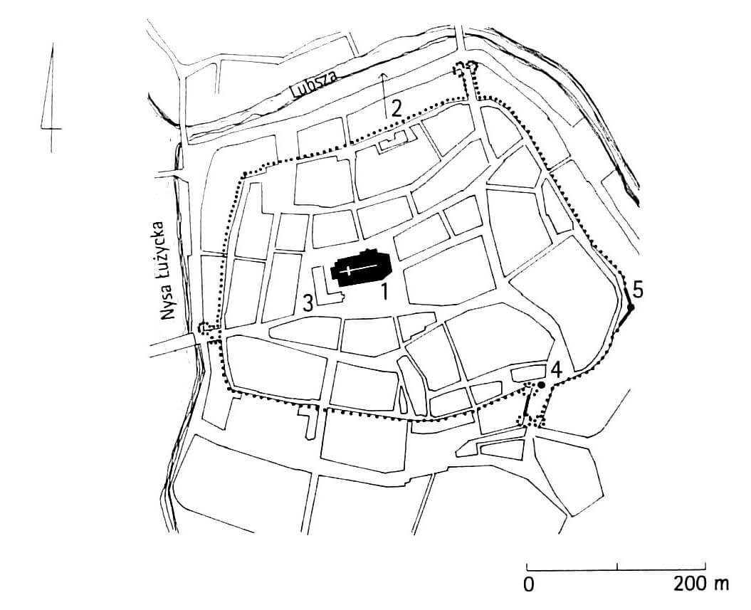
After the settlements scattered around the original village were included into the town limits, the fortifications formed a shape similar to an irregular pentagon with rounded corners. It covered an area of about 13 hectares, with a four-sided market square in the middle, traditionally connected in the corners with the main roads leading to the gates (only the north-western one led to a smaller wood market). From the north, south and west, the wall was separated from the compact buildings only by a narrow underwall street. In the east, the buildings were looser, and the fortifications were probably adjacent to the town gardens.
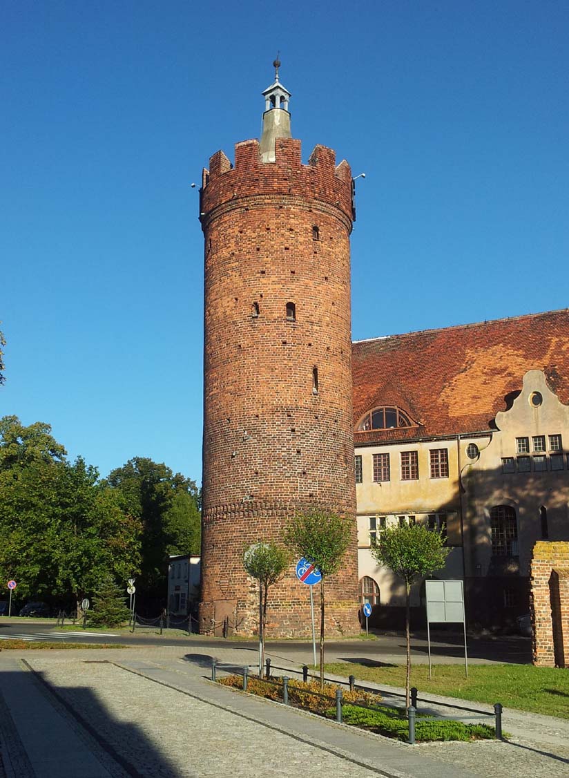
The defensive walls were about 7 meters high. It were reinforced with 31 half towers, which had the form of rectangular projections, placed quite regularly around the perimeter, protruding in front of the neighboring curtains and open from the town side. The erection of defensive works of this type was associated with lower costs, accelerated the construction process and protected against barricading after a possible capture of a section of fortifications by the enemy, exposed to fire from the town side. In addition, in key places for the defense of the Gubin, in the corners and at the gates, cylindrical towers were erected in the first half of the 16th century.
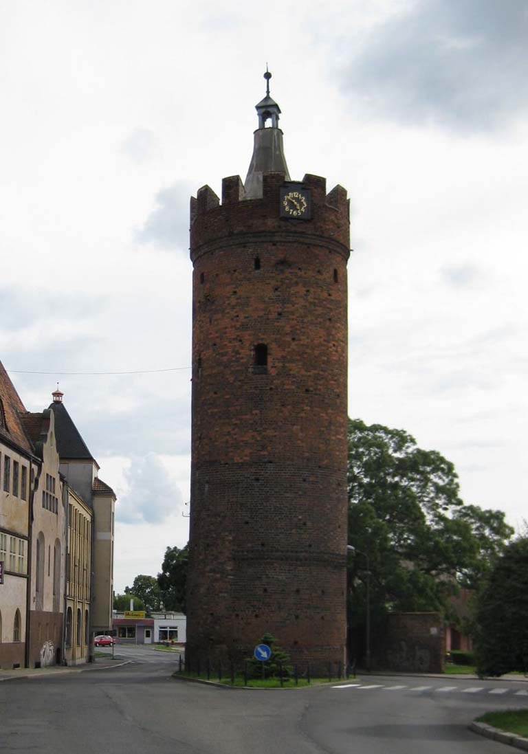
Three gates led to the Gubin: the Monastery Gate on the south-west side, the Krośnieńska Gate on the north-east and the Ostrowska Gate on the south-east. The Monastery Gate was located on the Nysa River, the Krosno Gate was directed towards the crossing through Lubsza, and the Ostrowska Gate on the road leading through Lubsko and Żary to Silesia. In the years 1523 – 1544, all gates were reinforced with foregates with external, cylindrical towers or bastions.
Current state
To this day, only small fragments of fortifications have survived, among which there is the so-called the Virgin Tower with short sections of the defensive wall in the eastern part of the former perimeter, located in the bend of Drukarska and Dąbrowskiego streets, on a private property. In addition, in the south-east, the tower of the Ostrowska Gate from around 1523-1530 (also called Thick Tower), located in the middle of 3 Maja Street, has been preserved. In the vicinity of the latter, there are also visible remains of the former foregate of the Ostrowska Gate from the 16th century. The 19th-century element is a fragment of the wall with a gate flanked by pseudo-towers, erected at the square on Dąbrowskiego Street.

bibliography:
Biała karta ewidencyjna zabytków architektury i budownictwa, pozostałości zespołu murów miejskich, J.Sawiński, nr 1570, Gubin 2005.
Gander K., Geschichte der Stadt Guben, Guben 1925.
Kowalski S., Zabytki architektury województwa lubuskiego, Zielona Góra 2010.
Pilch J., Kowalski S., Leksykon zabytków Pomorza Zachodniego i ziemi lubuskiej, Warszawa 2012.
Przyłęcki M., Miejskie fortyfikacje średniowieczne na Dolnym Śląsku. Ochrona, konserwacja i ekspozycja 1850 – 1980, Warszawa 1987.
Studia nad początkami i rozplanowaniem miast nad środkową Odrą i dolną Wartą (województwo zielonogórskie), red. Z.Kaczmarczyk, A.Wędzki, tom 2, Zielona Góra 1970.