
History
The first fortifications of Grudziądz, probably wood and earth, began to be erected shortly before or after the foundation of the town, which took place in 1291, although the settlement associated with the castle, and earlier the hilllfort, functioned at least from the first half of the 13th century (in 1277 the chronicler Petr of Dusburg called Grudziadz “civitas et castrum”). It is true that a gate was already recorded in the foundation document, but the oldest fortifications could not be too strong, since in 1286 the Grudziądz Teutonic commander ordered the evacuation of the inhabitants for fear of a Tatar invasion.
In the fourteenth century, a brick wall was built on the site of older fortifications. The town walls were raised and modified several times, especially the tower system was extended, and the wall on the edge of the escarpment from the Vistula side was gradually replaced with a line of defensive, multi-storey granaries. In the first half of the 15th century, due to the development of firearms, a second, outer line of the wall was created on the two most endangered parts of the town.
At the end of the first half of the fifteenth century, the burghers of Grudziądz joined the anti-Teutonic opposition in the form of the Prussian Union. It is true that even before the outbreak of the war in 1454, they sent an envoy to the Grand Master Ludwig von Erlichshausen with a declaration of allegiance, but at the beginning of February they began siege of the Grudziądz Castle, where the commander Wilhelm von Helfenstein was not present. The castle, along with a large group of supporters of the order, defended itself for several days, but as a result of shelling from the town side and undermining of the walls on the eastern side, it finally surrendered. This ended the period of the Teutonic Knights rule over the town, which was part of the Kingdom of Poland, despite several attempts to recapture Grudziądz by the Teutonic army, which lasted until 1466.
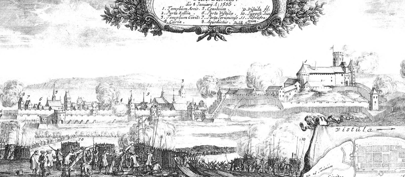
In the second quarter of the 17th century, Grudziądz was attacked by the Swedish army by Gustaw Adolf. The town’s fortifications were hastily reinforced with earth ramparts, although, thanks to the actions of Hetman Koniecpolski, the Swedes gave up conquering the town and the castle, contented with ravaging the surrounding areas. Grudziądz was seized in 1655, when the electoral army to defend the town withdrew without trying to fight. The Polish army recaptured Grudziądz in 1659 after an intense artillery fire, which destroyed the buildings and the already obsolete medieval fortifications. Their remains were dismantled in the second half of the 19th century due to the dynamic urban development.

Architecture
The medieval town was situated on the high eastern bank of the Vistula River, elevated above the Grudziądz Basin. From the north, it was adjacent to the hill occupied by the Teutonic Knights castle, while on the eastern side of the town the area lowered, creating vast wet meadows, difficult to cross in spring and summer, and Lake Tuszewskie, where the Teutonic mill operated. Also in the south there was a marshy lowering of the area, additionally cut by a stream, and from the middle of the 16th century by the Trynka Canal, running from the Osa River, which flows into the Vistula River on the northern side of the town. The further southern foreground of the town was occupied by a fishing settlement, later constituting a small Toruń Suburb. From the west, the straight riverbed of the Vistula under the town narrowed significantly, making it possible to organize the ferry.
The town’s fortifications were erected on a plan similar to an elongated quadrilateral, situated along the river, with its longer sides on the north-south line. It covered a regular network of streets with a rectangular market square in the middle, and there was probably an underwall street on most of the perimeter. Near the walls there was a church of Holy Spirit with the hospital, filling the south-west corner of the town, while the parish church of St. Nicholas was adjacent to the street that stretched along the riverside granaries. Initially, the fortifications consisted of a single line of brick defensive wall and a moat preceding it, connected in the northern part with the previously erected fortifications of the Teutonic castle. From the side of the Vistula, the wall line was replaced in the fourteenth century by two-storey, high granaries, fulfilling equally or even better defensive functions, because they had a number of small openings and arrowslits in the thick outer walls. In this section, due to the high, riverside slopes, the creation of a moat was unnecessary. The moat was filled with water from the stream and the Trynka Canal. The curtains were topped with an open wall-walk protected by a battlement.
The circumference of the defensive walls was reinforced with about seven towers. Most of them were rectangular in plan and open from the town side, which reduced costs and accelerated the construction, and at the same time made it impossible for the enemy to seize and barricade the building after a breakthrough was obtained. The half towers were extended in front of the adjacent curtains, and their height was equal to or higher by one or at most two storeys from the defensive wall. The south-east and perhaps north-east towers had the form of closed quadrilateral buildings due to the location in the corners of the town. The tower north of the Side Gate was the only one, for unknown reasons, built on a circular plan. Almost all the towers were erected in the eastern part of the perimeter, the most endangered by a potential attack and the longest at the same time. Their spacing was not regular, they were from 30 to 70 meters apart (taking into account also the gates). Over time, the back walls of the half towers were closed with the back walls, which allowed to place supplies, weapons or ammunition stores in the ground floor.
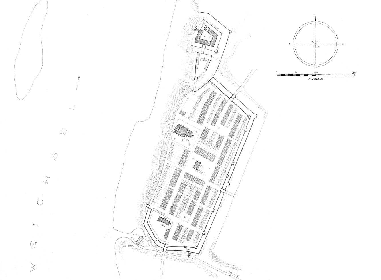

Four gates led to the town: Toruń Gate from the south, Kwidzyn Gate from the north, Water Gate leading to the Vistula port and a mill in the south-west corner of the town, and Side Gate from the east, leading to meadows and town pastures. In addition, there was the Castle Gate, connecting both defense organisms. The Toruń Gate and the Kwidzyn Gate were situated on the main axis of the town, while the east-west communication was of less importance. This distinguished Grudziądz from most Hanseatic port cities with one long, wide street parallel to the waterfront with which the cross streets joined. Grudziądz had a greater number of smaller, narrow streets perpendicular to the Vistula, leading to the granaries, and its location on a high slope meant that there were no gates on the west side. An additional element that facilitated everyday life was the Dung Gate, most likely an ordinary hole for removing waste.
Grudziądz gates were in four-sided towers, protruding on both sides in front of the adjacent curtains. In their ground floor there were passages about 2-3 meters wide, closed with portcullis and possibly with doors. From the side of the entrance to the town, they could have decorated facades, for example, the Toruń Gate was decorated with three long blendes. In front of the gatehouses, there were bridges over the moat, while the bridge in front of the Toruń Gate very early received a brick form.
In the first half of the fifteenth century, a second, external, lower defensive wall was added from the south and east, created between the moat and the older curtains. In addition, the Toruń, Kwidzyn and Water gates received foregates, connected with the outer ring of fortifications. The new wall was topped with a battlement and an open wall-walk, and one tower or a bastion in the north-east corner was placed in its line. The width of the zwinger was about 9-10 meters.

Current state
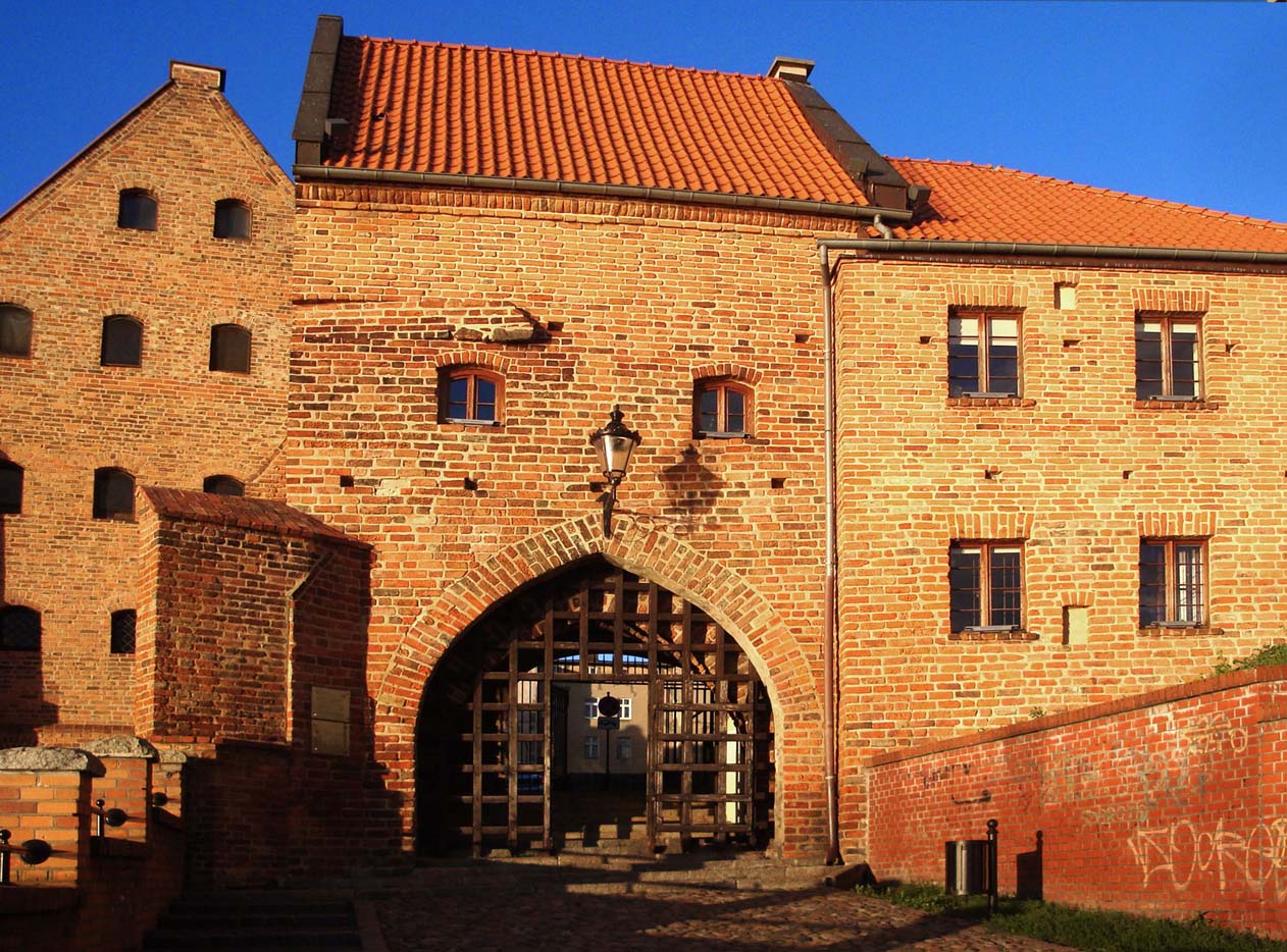
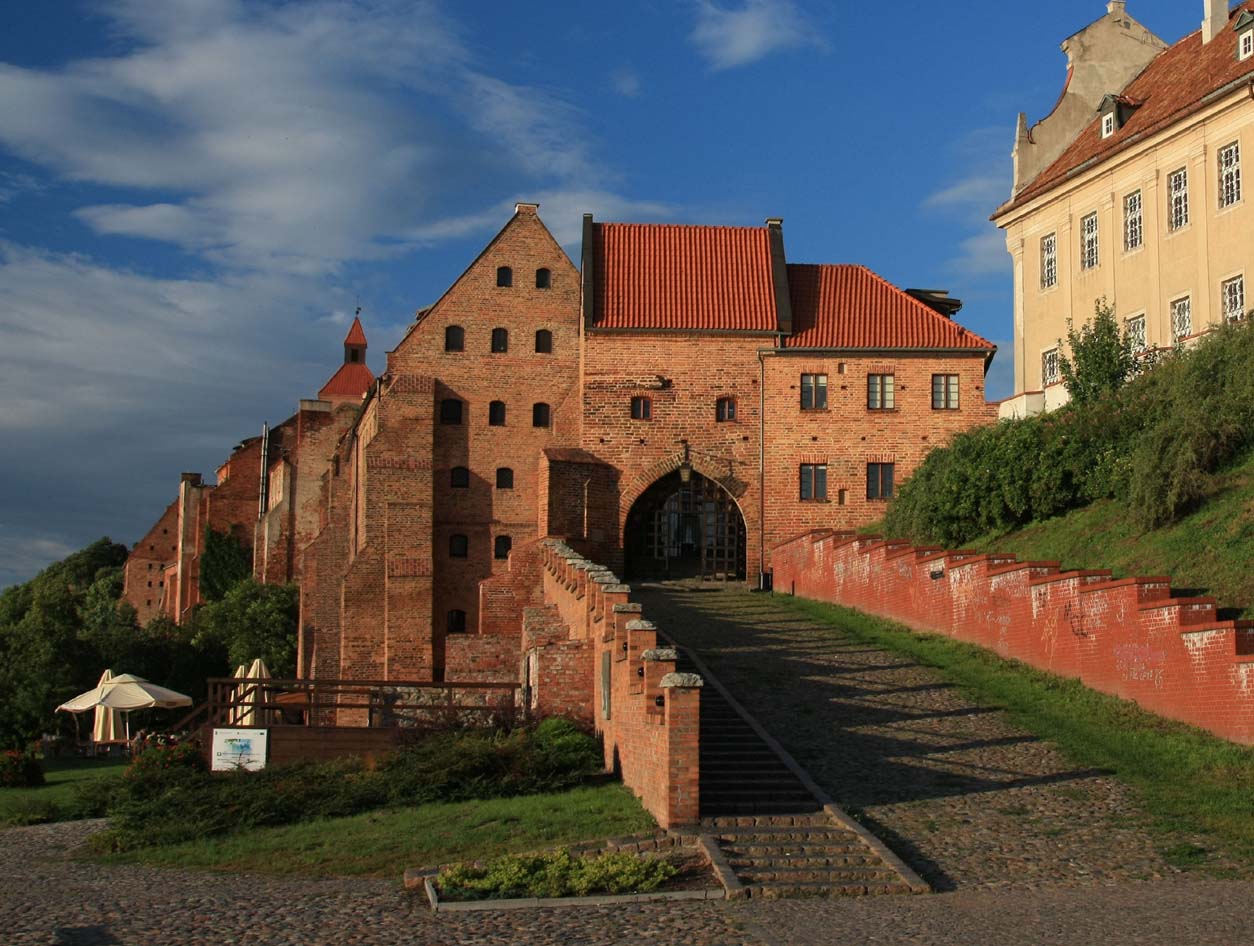
The rebuilt Water Gate has been preserved to our times, the lower part of which has an arched passage from the 14th century. The upper part was rebuilt for residential purposes in the 17th century. In its best condition it survived the south-east section of double walls between the outlets of Klasztorna and Szkolna streets with well-preserved fragments of the tower and the wall. A very valuable monument is the bridge from the first half of the 13th century, which is an element of the Toruń Gate site. It is possible that it was created earlier than the gate itself and is probably the oldest preserved bridge in Poland.

bibliography:
Atlas historyczny miast polskich. Tom I Prusy Królewskie i Warmia, red. A.Czacharowski, zeszyt 4 Grudziądz, Toruń 1997.
Die Bau- und Kunstdenkmäler der Provinz Westpreußen, der Kreis Graudenz, red. J.Heise, Danzig 1894.
Olszewski J., Fortyfikacje Grudziądza z okresu średniowiecza i okresu wojen szwedzkich [w:] Dzieje fortyfikacji Grudziądza, red. J.Kufel, Grudziądz 2014.