
History
Settlement in Gorzów has existed since the early Middle Ages, stimulated by the location at the river crossing at the intersection of two trade routes: from the lands of the Polabian Slavs to Wielkopolska and from Silesia to Pomerania. In the middle of the 13th century, this area was occupied by Brandenburg, whose ruler, Margrave John, established the town of “Landisberch Nova” in 1257. As a result, Gorzów (Landsberg) received regular planning and economic privileges favorable to the development of trade and crafts, as well as permission to erect fortifications.
The first fortifications erected after the foundation of the town were of wooden and earth construction. The foundation act stipulated that until St. Martin day of 1257, a fence or a makeshift palisade and a ditch were to be built, and then a solid palisade preceded by a moat. The initial fortifications began to be replaced with stone wall from around the begining of the fourteenth century. The first document confirming their functioning was recorded in 1325. In the late Middle Ages, the town walls could be modernized due to the spread of firearms (e.g. loop holes in the parapets, foregate of the Santok Gate).
The walls of Gorzów turned out to be an effective protection of the town. They were not forced by the Lithuanian army in 1326, nor by the Hussite army, which in 1433 besieged the Gorzów for seven days. Only in 1631, during the Thirty Years’ War, some of the fortifications were demolished by the Swedish army, but it was already a period of loss of the importance of medieval fortifications due to the development of artillery. In the 18th century, planting of ramparts and a moat began, and in the first half of the 19th century, the walls began to be dismantled. Already around 1740, the tower of the Bridge Gate was demolished, then at the turn of 1827 and 1828 the Mill and Santocka Gates were slighted. The demolition of fragments of the walls lasted at least several dozen years, with the last large fragments destroyed in 1882.
Architecture
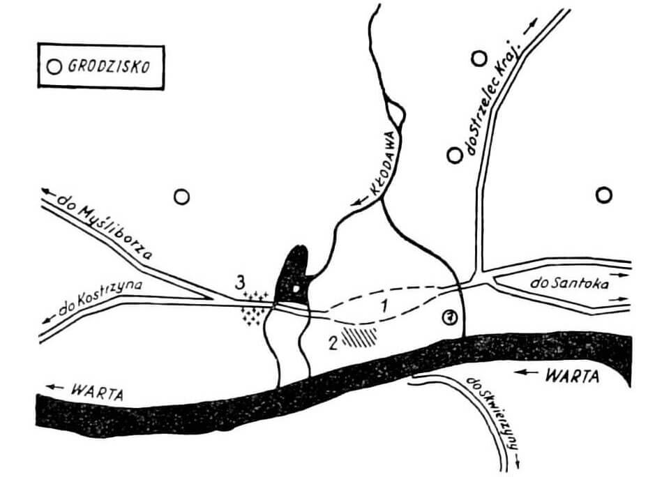
The tpown was founded in the valley of the Warta River, on its northern bank. On the western side of Gorzów, to the Warta flowed from the north the smaller Kłodawka River, which had previously been connected to the Srebrna River. Kłodawka carved a perpendicular, side valley, and at the mouth formed a vast alluvial fan, occupied by a medieval town. This hill from the south, west and north was surrounded by river waters and swamps. Only from the east, through a narrow strip of dry, slightly elevated areas, it was connected to the bend of the hills of the edge of the proglacial valley. Originally, one of the branches of Kłodawka flowed between these hills and the town area, and a narrow and long pond ran parallel to it. The second pond on the western side of the town was created by two canals of Kłodawka.
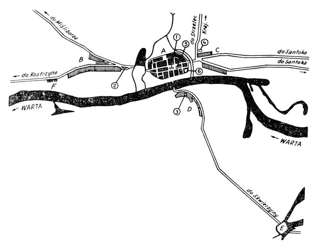
A small suburb with a hospital and the church of St. George formed on the left bank of the Warta River. To the west of the town there was a Slavic settlement (chyża), and just in front of the gate there was a 13th-century Mill Suburb with the church of Holy Spirit. Late medieval suburb with the chapel of St. Gertrude and the hospital developed along the road running east. A settlement or a Cistercian grange called Cow’s Fort, located by the bridge over the old Warta River, a few kilometers south of the town, probably had military significance.
The shape of the fortifications in the plan was adapted to natural conditions, because the southern part of the perimeter, adjacent to the Warta River, was made straight, while the other sections had larger or smaller curves, without sharp and right angles that would make defense difficult. The longer axis of the town was created on the east-west line, marked by two main roads crossing the market square and passing the parish church. A series of smaller transverse streets separated from these roads, directed especially towards the riverside gates and wickets. Access to the fortifications was facilitated by an underwall street from the inside of the town. In the south-eastern part of the complex there was a castle, which had its own defense system.

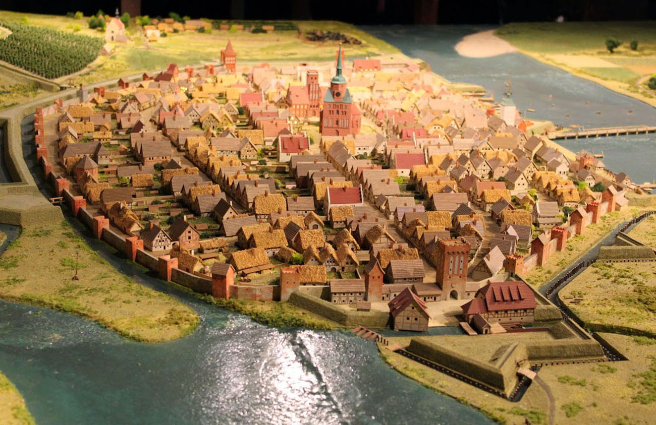
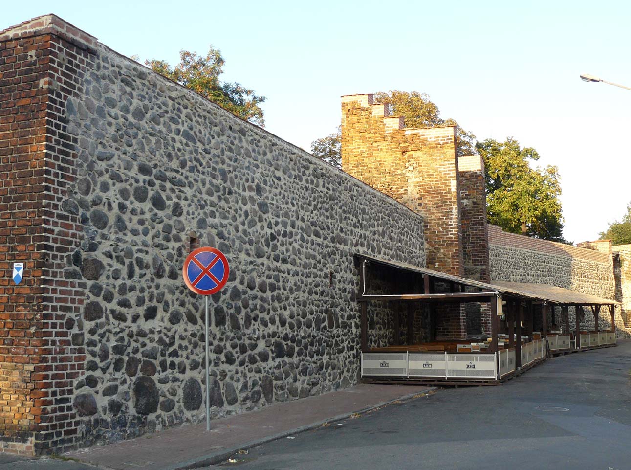
The defensive walls were built of layered stone pebbles, also small amounts of erratic stones were used, bonded with lime mortar reinforced with chicken protein. Bricks were also used to fill in the gaps, superstructure curtains and especially towers and to make loop holes. The thickness of the wall at the base was 0.9-1.4 meters, and at the top from 0.8 to 1.1 meters. Since the popularization of hand-held firearms, they were pierced with loop holes, which were located in a straight parapet, behind which communication took place on a wooden porch. The total length of the perimeter of the walls was about 1,700 meters. The outer defense zone was a moat and a river supplying it with water.
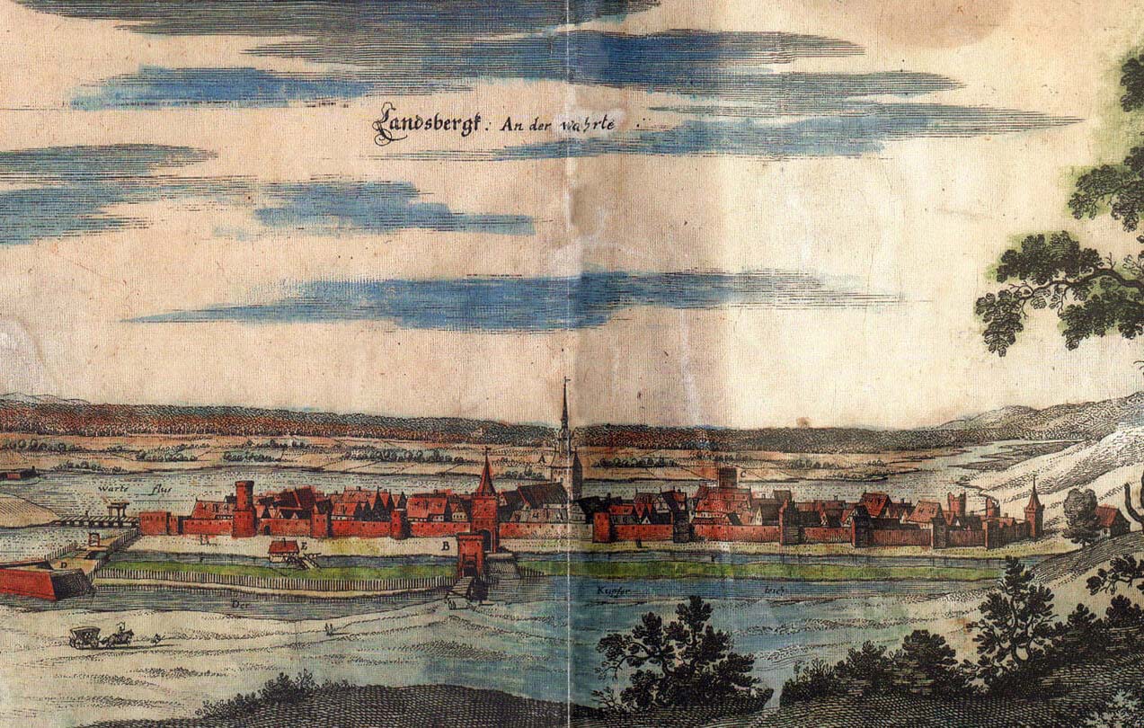
The defensive wall was reinforced with 30 or 32 four-sided half towers. On the north side, between the Mill and Santocka gates, there were 21 of them, while the southern part of the perimeter, facing the Warta River, did not have a single one. The towers were protruding in front of the face of the wall and were opened to the interior of the medieval town. They had two or three storeys inside, separated by wooden ceilings for which sockets in the walls were intended. The side and front walls of the towers had slit loop holes, embedded from the inside in recesses with stepped heads, placed on the middle and upper floors (the lowest floors had to act as warehouses, as long as they were closed with wooden or half-timbered screens). Communication between the floors took place through a narrow, single-flight staircase at the left (west) wall of each of the towers.The dimensions of the towers oscillated from about 5.8 to 6.8 meters in length and from 2.5 to 4.6 meters in width. In the late Middle Ages, some towers could be made higher, closed from the side of the town and raised up with cylindrical storeys (such a tower is visible on M. Meriana’s veduta).
Three gates led to the town: Santocka Gate in the east, Mill Gate in the west and Bridge Gate in the south. The first two were directed to land routes, and the third to the river crossing. In addition, there were several posterns or wickets from the north, and especially from the south, facilitating communication and access to the commercial wharf. The main gates were in the form of four-sided towers with passages in the ground floor. From the late Middle Ages, the Santocka Gate was preceded by a foregate, consisting of a gatehouse protruding into the foreground, connected by a neck with the main gate tower.
Current state
Of the former town fortifications, only a 130-meter-long fragment of the lowered defensive wall in the north-eastern part of the former perimeter, between Hawelańska and Zabytkowa streets, has survived to this day. There are four half towers in its line. From the outside, in place of the moat, there is a square, and from the inside, Zabytkowa Street is a remnant of the old underwall street.
bibliography:
Biała karta ewidencyjna zabytków architektury i budownictwa, mury obronne miasta, T.Witkowska, nr 1102, Gorzów Wielkopolski 2002.
Kowalski S., Zabytki architektury województwa lubuskiego, Zielona Góra 2010.
Pilch J., Kowalski S., Leksykon zabytków Pomorza Zachodniego i ziemi lubuskiej, Warszawa 2012.
Studia nad początkami i rozplanowaniem miast nad środkową Odrą i dolną Wartą (województwo zielonogórskie), red. Z.Kaczmarczyk, A.Wędzki, tom 1, Zielona Góra 1967.