
History
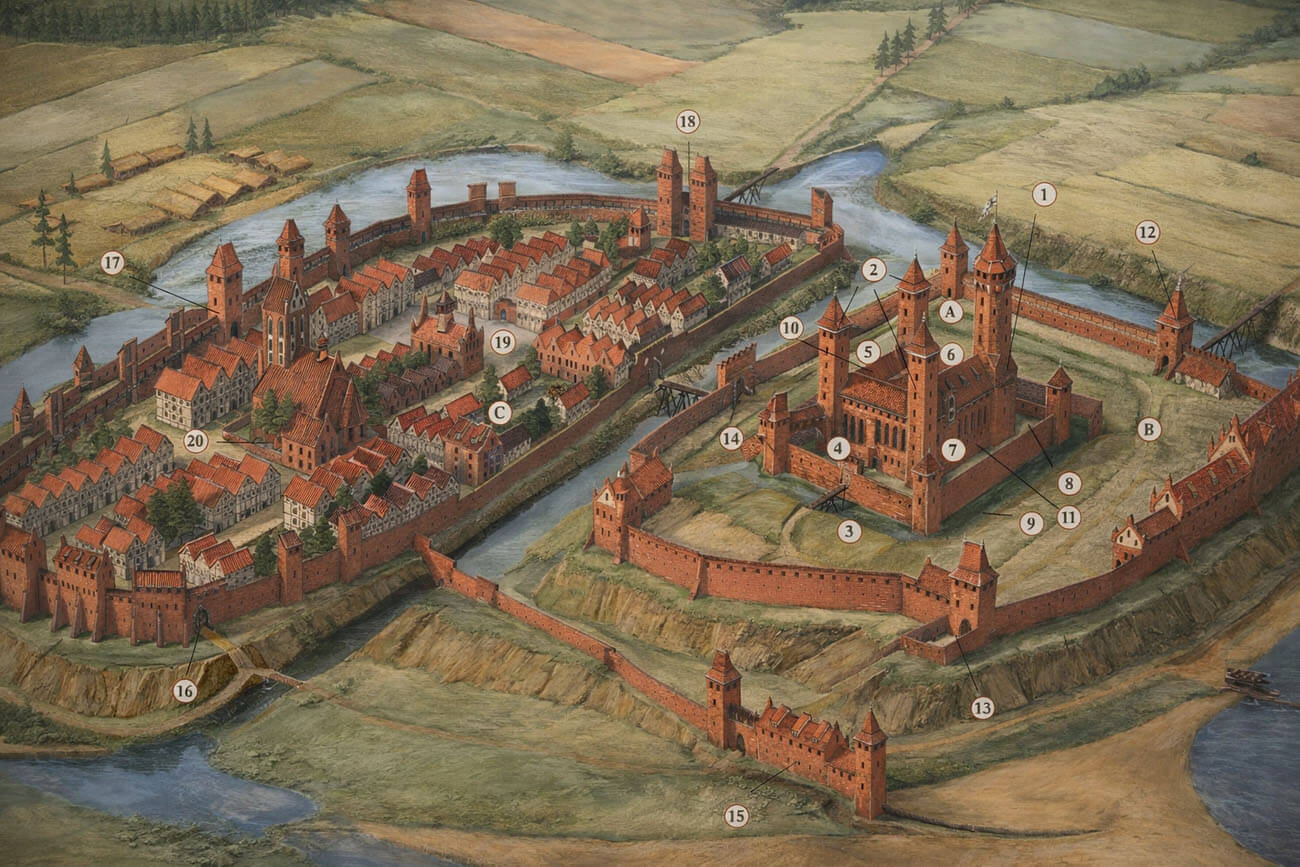
The construction of defensive walls in Gniew began after the foundation of the town in 1297. The construction was to be carried out by the Teutonic Order itself, which captured Gniew as a result of dynastic disputes of Pomeranian rulers. The new owners wanted to make the town and the castle a fortified starting point for the conquest of neighboring lands. Gniew also became an important link binding the defensive line on the Vistula and protected the river ferry. The exact start time of construction works is unknown. The foundation document only states that “we undertake to strengthen the town when the brothers consider this to be the most favorable for them and for this land.” This commitment was exceptional and testified to the importance of Gniew for the Teutonic Knights. For this reason, it is assumed that the construction of the town walls was not delayed for too long, and the above reservation was associated only with the priority of fortifying the castle.
Modernization works were carried out in the later years of the 14th century, when a second belt of fortifications was added to part of the circuit, and in the 15th century, probably after the experience of the defeat of the Teutonic Order in the Great War with Poland. It is also possible that modernizations were associated with the reconstruction of the castle from 1422, when, after resignation, the recent Grand Master Michael Küchmeister moved from Malbork to Gniew.
During the Thirteen Years’ War, the town walls and especially the gates suffered damages, although they were quite effective in resisting attacks. The town was captured only after prolonged sieges and the cut off of ammunition and food. After signing the Second Peace of Toruń in 1466 and Gniew returning with Pomerania to the borders of the Polish kingdom, the town lost its strategic importance, so it was not in a hurry to repair its fortifications.
In the 17th century, due to the growing threat from the Swedes, medieval fortifications were strengthened by building earthworks and bastions. Hetman Koniecpolski took care of the modernization of the fortifications, creating a defense of ferry at the Vistula in Gniew, but the early modern ramparts were quickly destroyed. In 1664 they were already described as dilapidated. Beginning in the 18th century, the medieval town fortifications began to fall into ruin, and in the 19th century, all town gates and parts of the Gothic defensive walls were demolished.
Architecture
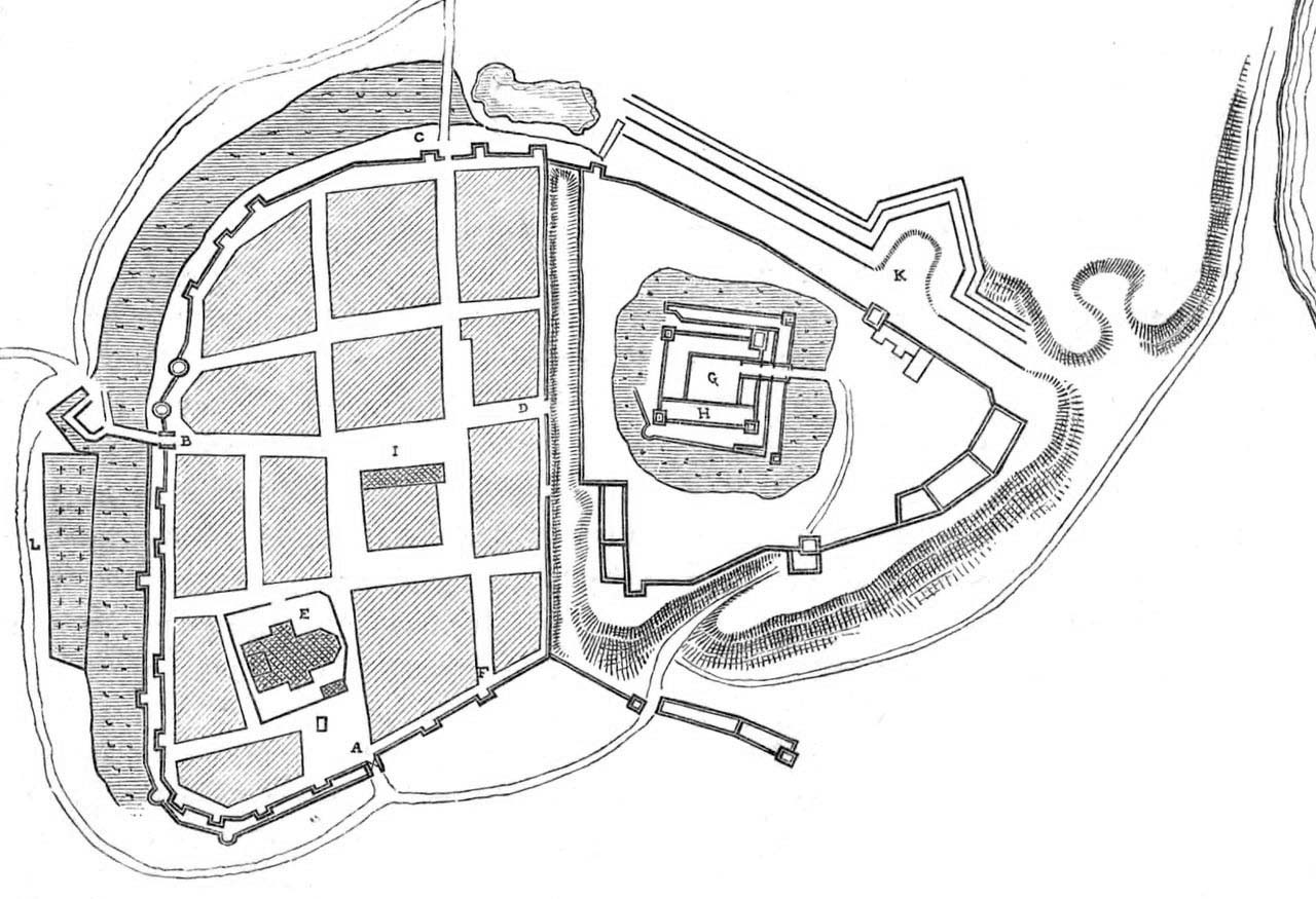
The medieval town was situated on the western bank of the Vistula River, in the immediate vicinity of the castle, on its western side. The layout of Gniew was related to the older settlement and old roads that led north along the Vistula River, north-west to Gdańsk, Pelpiln and Starogard, and to the road leading south to the haven and further towards Grudziądz. From the south, the town was limited by the Wierzyca river bed, flowing into the Vistula under Gniew and creating a swampy pool in the south-east. The town from the north was the least protected by the natural conditions of the area, as the range of hills on which the town and the castle were situated stretched there more or less at the same level.
The fortifications had an irregular shape similar to an oval with a more strongly outlined, though rounded corner on the south-west side and a straight eastern curtain, adjacent to the ditch separating the town from the castle. In addition, on the south-eastern side, a diagonally located wall line ran out of the fortifications ring, constituting the closure of the outer bailey foreground and acting as an additional protection of the riverside areas with the harbour and mills. On the south side, the foreground of the town fortifications was protected by the aforementioned Wierzyca, while the outer zone of fortifications from the north and west was the irrigated moat preceding the walls. In the south, the river escarpment provided sufficient protection.
The length of the fortifications was about 750 meters, while their construction proceeded in sections of about 15 meters (this is indicated by vertical joints visible until today). The walls were made of bricks, but they were placed on a special foundation about 1 meter high, in which irregular stone boulders, connected with mortar and brick debris, were included. The bricks were usually laid in a Flemish bond (stretcher and head alternately in each layer), but monk bonds were also used (alternately two stretcher and head). The wall thickness was about 1.2 meters. It was originally crowned with a battlement, along which a wooden porch for defenders ran from the town side. On the foreground of the town, an underwall street ran along the defensive walls. Its task was to facilitate the communication of defenders and faster movement during threat.
The town walls were reinforced with 14 towers, rectangular, two-storey, open from the town side and protruding in front of the line of walls. Two more towers on the west side were cylindrical, probably due to the proximity of the main gate to the town (Gdańsk Gate). They were created a little later, in the first half of the 15th century. At the level of the second floor, rectangular towers were equipped with loop holes, while at the top they were probably topped with battlements, later replaced with roofs. The towers were placed on each side except the eastern one, adjacent to the castle.
In the 14th century a second strip of the town wall was erected on the south-west side, providing additional protection on the section from the Gdańsk Gate to the Water Gate. It was probably slightly lower than the main perimeter, but reinforced with four half-towers: two semicircular and two quadrilateral.
Four gates led to the town: the Malbork Gate on the north side, the Gdańsk Gate from the west, the Water Gate facing south towards the Wierzyca River and the Castle Gate, as the name implies, being a connection with the Teutonic stronghold. In the vicinity of the Malbork Gate, the wall was connected with the fortifications of the castle, while the Mill Gate in the south-east and the Dybowska Gate in the north enabled communication between the town and the castle, access to the mills and fishing.
Current state
To this day, two fragments of the town walls have survived with small breaks and of an incomplete height. North-west route along Górny Podmur and Sobieskiego streets with three towers and a south-west fragment at Dolny Podmur street. Unfortunately, today the fortifications are largely obscured by garages and other modern buildings.

Bibliography:
Die Bau- und Kunstdenkmäler der Provinz Westpreußen, der Kreise Marienwerder (westlich der Weichsel), Schwetz, Konitz, Schlochau, Tuchel, Flatow und Dt. Krone, red. J.Heise, Danzig 1887.
Strzelecka I., Gniew, Warszawa 1982.
Sypek A., Sypek R., Zamki i obiekty warowne Pomorza Gdańskiego, Warszawa 2003.