

History
The first fortifications of Głubczyce, consisting of an arth rampart, a moat and a palisade, were probably built in the second quarter of the 13th century, in connection with the granting of charter to the settlement, which had to take place before 1253 (in this year, the Moravian Horni Benešov was founded under the Głubczyce law). In 1275, King Ottokar II of Bohemia confirmed the town privilege to the Głubczyce councils. The granted legal status accelerated the construction of stone fortifications of the town, which started in the third quarter of the 13th century. Soon after, Głubczyce was fully surrounded by a defensive wall, which was recorded for the first time in 1282, in a document of a settlement between the townspeople of Głubczyce and the Knights Hospitaller of Grobniki (monks were then allowed to pierce two posterns in the walls). Then, in 1298, the King Wenceslaus II granted the townspeople a privilege which allocated the income from the cloth chambers to the maintenance of walls, moats and roads.
In the fourteenth century, town fortifications were recorded several times in documents. The town gates themselves appeared as reference points in the acts for the sale of properties in their vicinity. The Lower Gate (Opawska) was mentioned in a document from 1383, informing about the sale of land by Prince Nicholas, and from 1388, in an act about the sale of the town mill. The Grobnica Gate, probably built a little later than the other two gates, was recorded in 1416 and 1441. A much later reference from 1565 recorded the fact that the town acquired the castle located at the Upper Gate.
In 1428, Głubczyce was threatened by the Hussites during a campaign against Przemek from Opava and the Silesians, but the town was probably not captured. During the next Hussite invasion in 1431, the town defended itself. Only when in 1436, Nicholas, the Duke of Racibórz, attacked and plundered Głubczyce. This first conquest of the town could have been the reason for the townspeople to repair and modernize the fortifications, especially the main gates enlarged by the foregates. In 1476, a great fire destroyed the entire Głubczyce, including timber elements of fortifications: the roofs of gates and towers, and combat platforms, which again forced repairs taking place in the 80s of the 15th century.
With the development of firearms, the medieval walls gradually began to lose their importance, despite the fact that at the beginning of the 17th century they were modernized in the Renaissance style. During the Thirty Years’ War, the town was additionally secured with earth ramparts. Their construction caused a change of the area directly adjacent to the town walls and destroyed part of the of Upper and Lower suburbs. The demolition of the walls began in 1764 on the basis of a royal decree. At the beginning of the 19th century, the town gates were demolished to widen the entrance to the Głubczyce, and in the 20th century, parks were established in the river backwaters.
Architecture
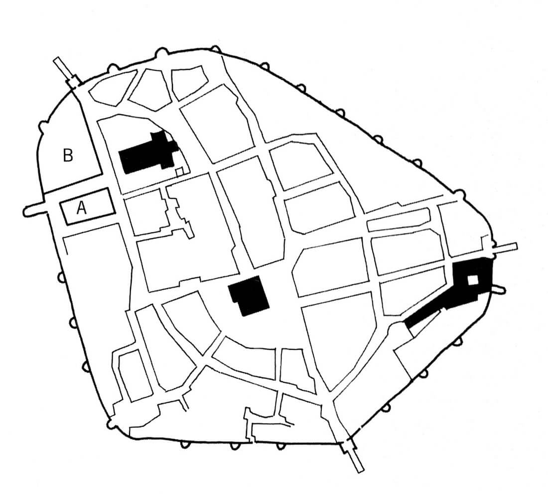
The Głubczyce fortifications surrounded a 16-hectare space with about 226 houses. The perimeter of the walls had the outline of an irregular oval resembling an equilateral triangle. From the south-east to the west, the fortifications were supported by the Psina pool and marshes. The defensive wall was made of clay slate. It was 5-6 meters high and about 1.5-2 meters wide. Adding a battlement to the height of 1.8 meters gave a total height of about 9 meters, which was the typical height of the walls of medieval towns.
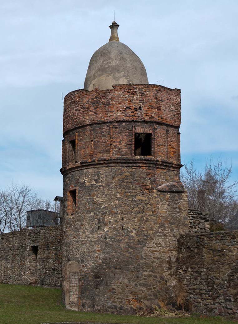
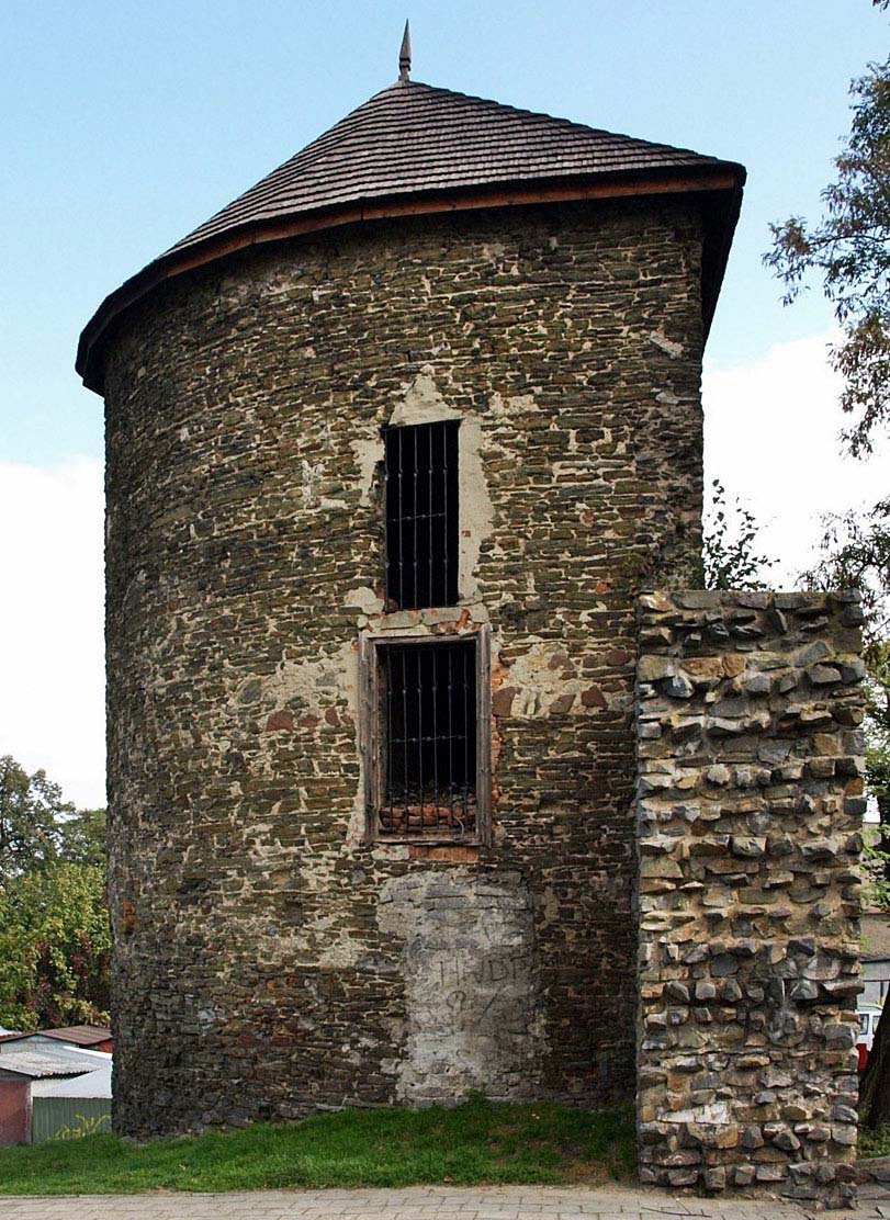
The Głubczyce walls were reinforced with 19 towers, three gatehouses and a moat. Seven towers were built on a semi-circular projection, and 12 on an unusual pointed projection. Originally they had a conical roofs covered with shingles, which was located above the guard porch. In the 15th century or at the turn of the 15th and the 16th centuries, some of them were rebuilt and raised, some topped with a dome at the top. The largest number of towers, as many as 9, had a section of walls between the Upper Gate and the Monastery Gate. Between the gates of Monastery and the Lower Gate there were 3 towers, while the longest of the sections of the wall, between the Lower Gate and the Upper, had only 7 towers. The distance between the towers on individual sections of the wall depended on natural factors. The southern part of the town was adjacent to the backwaters of the Psina river and the swamp area, whereas the vicinity of the Upper Gate up to the Grobnicka Gate was a clay land area that crossed a narrow strip of wetland near the town.
To the town led the Grobnicka Gate (or Monastery), standing near the Franciscan church in the eastern part of the circuit, the Upper Gate (Nysa Gate) from the north and the Lower Gate (Opava Gate) in the south. From the outer side of the town, all gates since the turn of the 14th and 15th centuries were additionally reinforced by foregates, consisting of a short neck and an additional building with a passage. The Upper Gate, compared to the towers of the other gates, was tall, impressive and its size could compete with the towers of the Gothic parish church. It also had wooden, metal-forged doors and a portcullis. In the room above the passage there was a powder magazine and a mechanism that activated the portcullis.
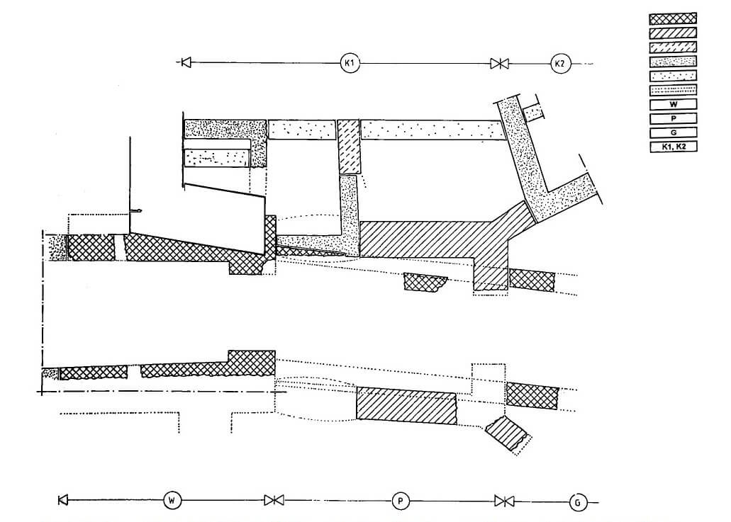
The tower of the Grobnicka Gate was erected on a quadrilateral plan with dimensions of 8.9 x 8.5 meters, with 2 meters thick walls in the ground floor. It had a gateway 3.2 meters wide, narrowed from the field side and probably closed with a semicircular arch. It was located in a large pointed-arched niche that acted as a guide for the lowered portcullis. At a height of about 10 meters, there was an offset on the wall, which could indicate the hoarding porch originally was located there. The oldest foregate of the Grobnica Gate had the form of a straight neck formed together with the gate tower. It was about 12 meters long, 5.7 meters wide, and was slightly shifted to the south in relation to the tower. At the turn of the 14th and 15th centuries, a four-sided foregate building with dimensions of 8×10 meters was erected in the place of the neck, reinforced at the outer corners with diagonal buttresses.
The outer zone of defense constituted swamps and backwaters of the Psina river from the south and southeast, which waters fed the town moat, protecting the town from the west and north. In the 14th century, two ponds were created, which further strengthened the outer zone of the town. Washerwoman Pond was located from the south-west and was divided by a dyke where the bridge was located. It used the natural course of the river, which influenced it and flowed south from the Grobnicka Gate. The second pond, known as Monastery, was located on the north-eastern side of the town and was also naturally powered with water from the stream.
Current state
At present, the best-preserved fragments of the defensive wall are in the north and north-west part of the former circuit, near the parish church and Koszarowa Street, on the west side at Wałowa Street (on the primary school square), in the southern part of Głubczyce, at the back of Nowy Świat Street, and in the south-eastern part of the town, near the Franciscan friary. Together with the wall curtains, nine towers have been preserved in different condition, some of them raised in the early modern period. None of the town gates has survived.
bibliography:
Legendziewicz A., Brama Grobnicka (zwana Klasztorną) w Głubczycach w świetle badań architektonicznych i ikonograficznych, „Opolski Informator Konserwatorski”, nr 12, Opole 2015.
Legendziewicz A., Selected City Gates in Silesia – research issues, “Czasopismo Techniczne”, vol. 3, Kraków 2019.
Stangret W., Badania archeologiczno-architektoniczne bramy Grobnickiej w Głubczycach, woj. opolskie, „Opolski Informator Konserwatorski”, nr 11, Opole 2013.