
History
The town of Głogówek, although founded around the mid-thirteenth century, entered the period of intensive development in the fourteenth century. In 1359, the townspeople received extensive economic privileges from prince Bolesław of Niemodlin, his successor, Henryk of Niemodlin, granted the town the Magdeburg charter in 1373, and soon afterwards, in 1379, he erected a collegiate church in Głogówek. It was probably during this period, which was favorable for the town, that work was also carried out on brick fortifications.
The oldest information about the existence of fortifications in Głogówek dates back to 1379. At that time, one of the town gates was mentioned, which was defined as a newly created. This indicates the probability of earlier existence of other gates and fortifications. The initiator of its construction was probably prince Bolesław of Niemodlin and the work was continued by his youngest son Henryk and perhaps also Władysław Opolczyk. The walls circumference was probably created over at least several generations. Probably the walls and gates were erected first and next towers were built.
In 1428, the Hussite army of Prokop the Great approached the town, but unlike many other Silesian cities, Głogówek did not have to defend itself and was not destroyed, despite the fact that the Hussites occupied the castle. Bolko V, the then prince of Głogówek and Prudnik, confirmed by oath that he is going over to their side. He remained the Hussite ally for the following years, actively taking part in armed invasions and greatly enriching himself. After the death of his uncle Bernard, Bolko V came into possession of the entire Duchy of Opole, which he ruled until 1465.
In the second half of the 15th century, Głogówek shared the fate of the Duchy of Opole. After the death of Bolko V it was ruled by his son Nicholas I, and from 1476 by his two sons, Nicholas II and John II the Good. The death of the latter meant that the duchy, together with Głogówek, passed to the Habsburgs, who pledged it to the Margrave of Brandenburg, George Hohenzollern. In 1562, Hans von Oppersdorff came into possession of Głogówek, and in 1595, George II von Oppersdorff acquired the Głogówek dominion. During the reign of his son George III, the town was besieged and captured by Swedish troops in 1643, during the Thirty Years’ War. The town walls were probably also damaged at that time. The fortifications were finally demolished around 1870, probably due to communication difficulties.
Architecture
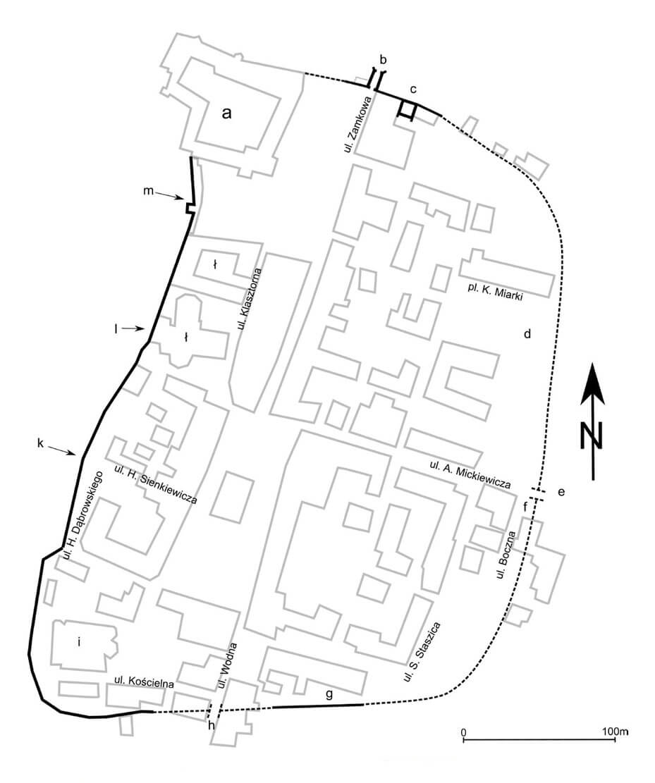
The defensive walls of Głogówek had approximately the shape of a rectangle, rounded in the corners and based on the north-east of the princely castle. From the west, however, the plateau on which the town was founded was surrounded by the Osobłoga River. The defensive walls closed the area of the medieval town of 11 ha.
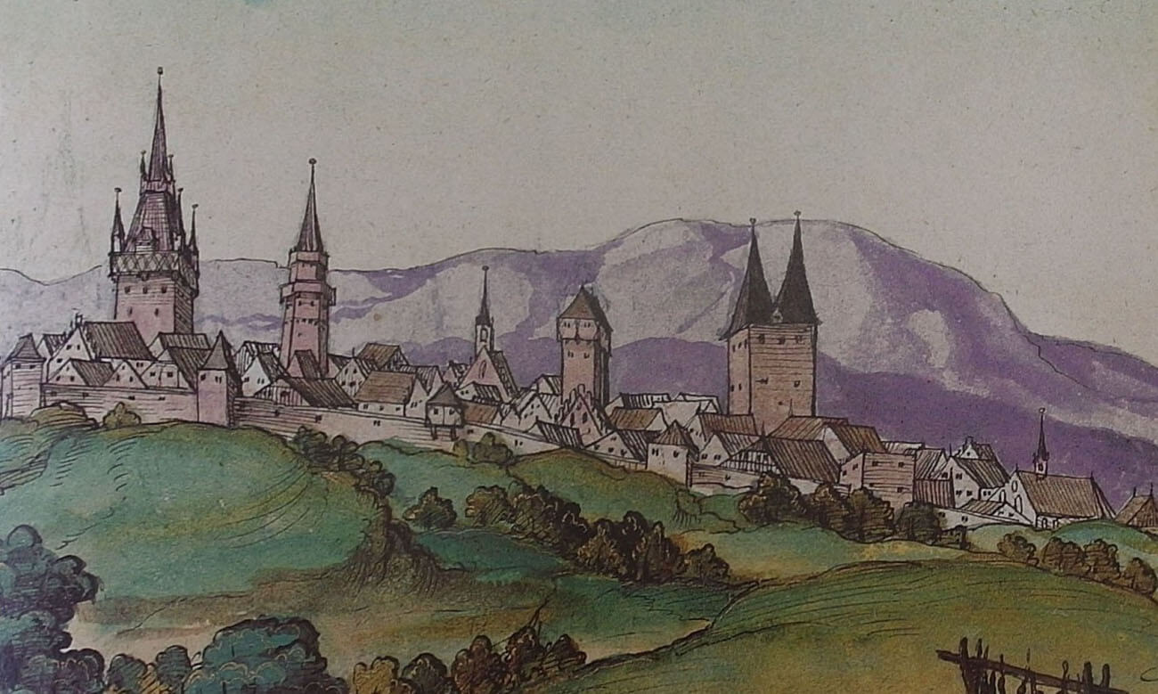
The thickness of the wall was about 1,6 meters, the height remains unknown, but it was certainly more than 6 meters. It was erected on a pillar-arch foundation. From at least the end of the Middle Ages, it was crowned with a covered wall-walk for defenders, in the breastwork of which arrowslits were pierced. The perimeter of the walls was probably reinforced with towers, and from the outside the foreground was secured by a ditch. On the veduta from the first half of the 16th century, four-sided towers of various sizes and finishes are visible, as well as bartizan hung on the wall.
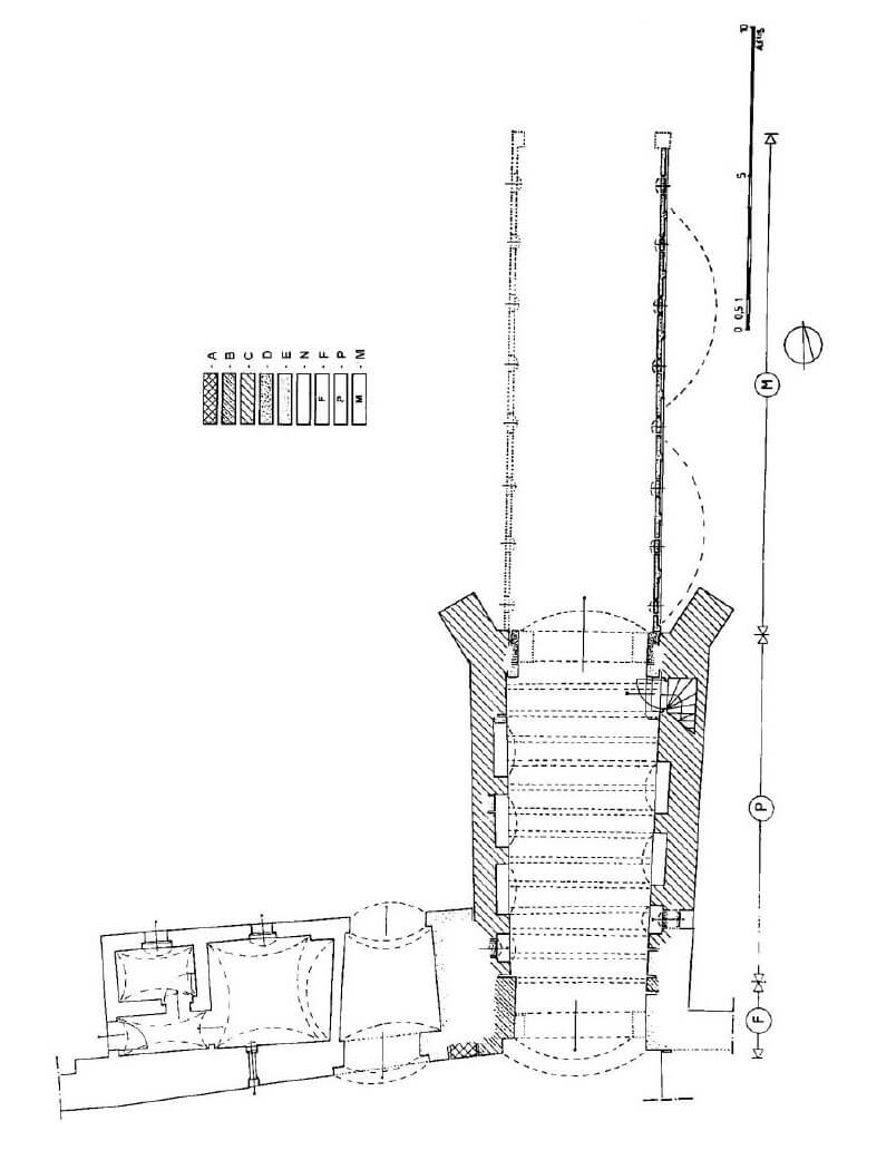
Three gates led to the town: Kozielska from the east, where it secured entry from Koźle and Kraków, the Castle Gate also called St. Mary’s Gate from the north, from the route from Krapkowice and Opole, and the Water Gate (Prudnicka) from the south, i.e. from Prudnik and Nysa. In the first half of the 14th century, Kozielska and Water gates were in the form of low, short four-sided gatehouses, closed by portcullises. The Castle Gate was probably initially a smaller wicket gate, rebuilt in the second half of the 14th century into a gatehouse measuring 6.5 x 2.5 meters in front of the face of the wall. A passage with a segmental crown was placed in it and probably closed with two-wing doors hung on hooks embedded in a recess from the town side. The gate width was about 3.5 meters. In addition, from the north the entrance was preceded by a bridge which last span was drawbridge. The gatehouse above the passage had a defensive floor probably with battlements and a porch for hoarding. During the extension of the second half of the 15th century, a two-storey foregate based on two arcades was added to the gate from the moat side. It was founded on a trapezoid-like plan, 6.9 x 8 meters wide and 14 meters long. Its side walls widened to the north, while the corners from the moat were reinforced by oblique buttresses. The entrance opening was probably covered with a segmental arch. It was probably closed by two-winged doors, and a bridge with a raised span at the foregate was probably placed through the moat. Foregate’s upper floor had probably a defensive function. The perimeter walls were topped with arrowslits, of which three were located in the west wall. The inner porch was based on brick walls, in the lower part with recesses (three from the east and four from the west), located at the level of the passage. In the ground floor, in both side walls, in a pair of recesses from the south from the south, semicircular holes were pierced to allow observation of the space under the curtain.
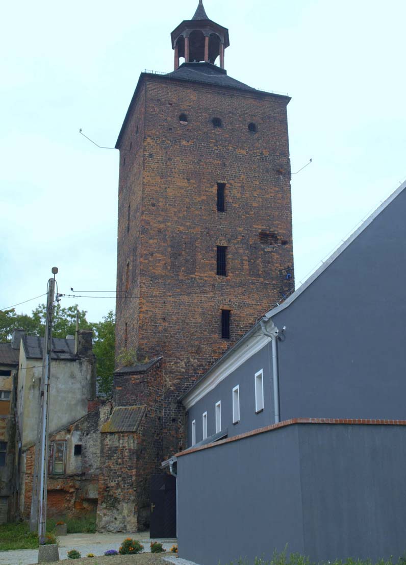
The Water Gate was flanked by a four-sided tower of an unknown name, and the Castle Gate a four-sided Prison Tower located about 15 meters to the east of the gate passage. Its name was derived from an unlit dungeon with a chain attached to the wall in its lower story. The higher five storeys, in addition to guarding and defensive functions, also served as warehouses, with the highest storey built in the second half of the 16th century. The tower was erected on a square plan with a side of about 8.3 meters. The thickness of its walls decreased with height, from about 2.5 meters in the ground floor, through 1.74– 1.9 meters in the third and fourth storeys to 1.4 – 1.45 meters at the top of the oryginal part. The height of the medieval part was about 20 meters. On the fourth and fifth floors there were four narrow windows, originally crowned with pointed arches, on the third floor three pointed windows and the entrance to the tower from the wall-walk. At the level of the fourth floor, there were originally blind windows (blendes), four on each of the walls. The corners on the north side (from the outside of the town) were supported by two diagonal buttresses, about 8.5 meters high. Between them, as well as on the eastern façade, there were relief brick arches.
Current state
To this day, a few, heavily reduced fragments of the town wall have been preserved. Among the town gates, the Castle Gate is the only one to survive, unfortunately in the form transformed in early modern times. Near the Castle Gate there is a guard and prison tower, raised by one floor in 1595. Currently, it is the seat of the Regional Museum. Its collections are ethnographic exhibits, illustrating the culture of life of the inhabitants of the former Głogówek and the surrounding area. Of particular interest are the former prison cells, one of which centuries ago served as a torture chamber.
bibliography:
Chrzanowski T., Głogówek, Warszawa 1977.
Legendziewicz A., Architektura bram miejskich Głogówka od XIV do XX wieku, „Kwartalnik Opolski”, 4/2018.
Przybyłok A., Mury miejskie na Górnym Śląsku w późnym średniowieczu, Łódź 2014.
Siemko P., Zamki na Górnym Śląsku od ich powstania do końca wojny trzydziestoletniej, Katowice 2023.