
History
The source information about the hillfort on the Tumska Island on the Odra River comes from 1010 and 1017. Timber – earth fortifications discouraged than from the attack the army of emperor Henry II. Again Głogów became famous in 1109, when the defenders heroically repulsed the army of emperor Henry V. During the period of fragmentation of Silesia, Głogów was the capital of a separate duchy, and then from 1241 belonged to Henry the Bearded and Henry II the Pious. In 1251, it became the capital of a separate duchy again, which meant that prince Conrad I, the youngest son of Henry the Pious, in 1253 established a town on the left bank of the river under the Magdeburg charter, which took over the role of a decline early medieval stronghold. The prince wanted to increase the economic potential of Głogów, but also to make it a more modern defensive center.
The brick town walls in Głogów were built in the last quarter of the 13th century, replacing the earlier wooden and earth walls destroyed after the town fire in 1291. The construction of the walls lasted for a long time, probably a dozen or even several dozen years. Throughout the 14th and 15th centuries, the walls were renovated and supplemented with new elements. In the first half of the fifteenth century, the town was surrounded by the second ring of walls. Zwinger was mentioned since 1439, while in the second half of the fifteenth century sources mention earth ramparts.
Under unknown circumstances, the defense system was taken over by the town council. Obtaining this privilege created the basis for the independence of the townspeople who, as in the years 1480 – 1488, could clearly oppose the will of the prince, ordering the town to be defended against the army of Matthias Corvinus. This privilege was also associated with the obligation to maintain the fortifications in good condition. Each social group had its own specific area to defend itself. Butchers defended the Hospital Gate, bakers of the Polish Gate, shoemakers and tanners of the Mill Gate, smiths defended the “vighaus” bastion, the tailors of the walls near the Corpus Christi church, the weavers that were the most of the north side of the fortifications, and the furriers of the fortifications near the bishop and the Franciscan monastery.
In the 15th century, the town suffered many defeats, especially during the reign of the prince of Żagań, Jan II, who in the years 1476-1482 led the war with Brandenburg for the principality of Głogów. Again fortifications did not protect the town in 1488 during the siege led by the Hungarian army of Matthias Corvinus. At the beginning of the 16th century, thanks to the development of crafts and trade, the town was rebuilt and enriched, which, with the development of firearms, led to the creation of the early modern bastion fortifications in the first half of the 17th century. The medieval archaic walls were neglected and, over time, were mostly dismantled.
Architecture
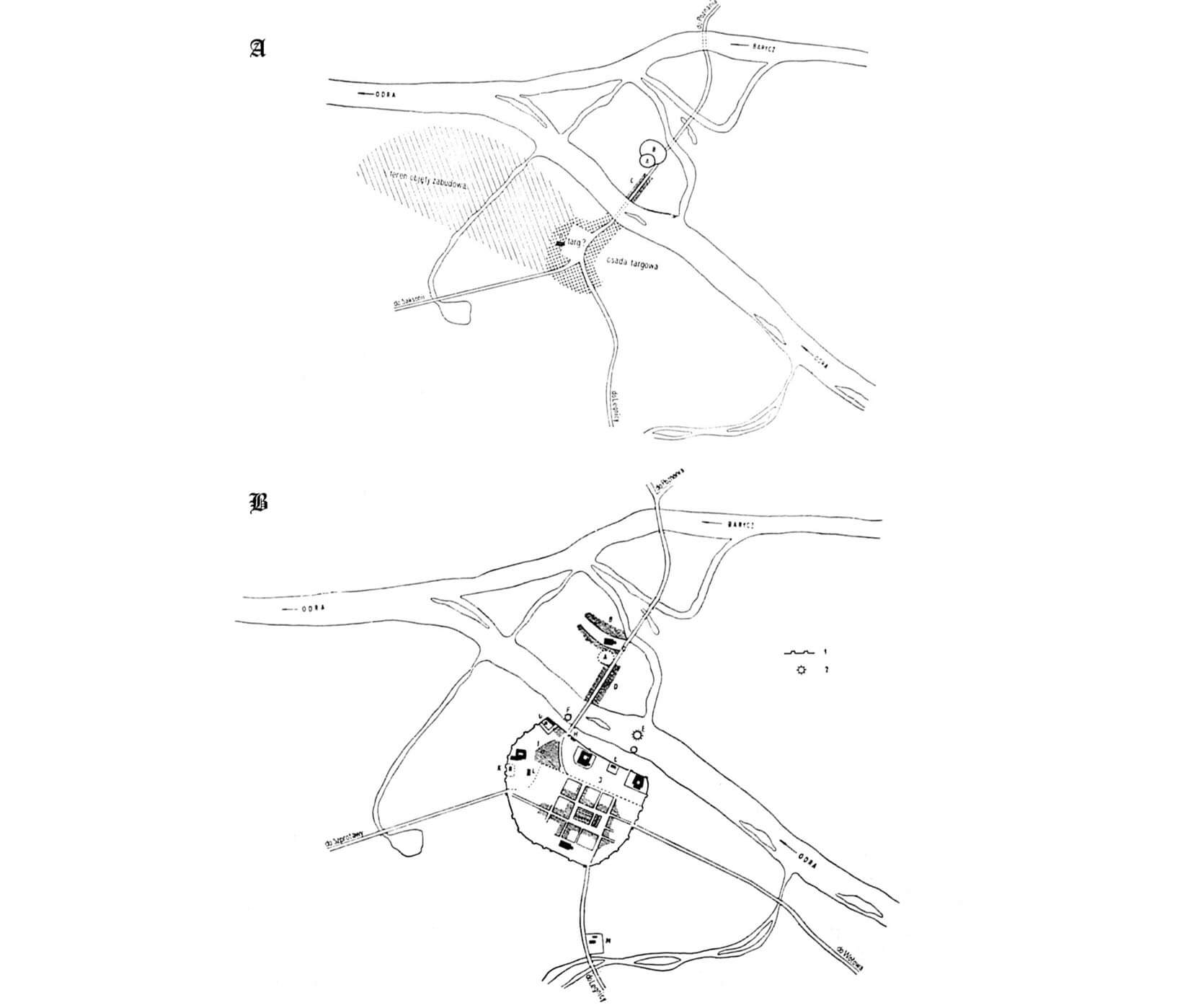
The town developed in the area of a market settlement, on the southern bank of the Oder river, near the crossing, in a place where a wide, meandering riverbed forming numerous sandbanks flowed in a wide glacial valley. The ford ran through a wide but not swampy pool, first through the main bed of the river and sandbanks, then through a branch called the Small Oder, and then through the Barycz River, which joined the Oder near Głogów. In the place of the ford passing through Ostrów Island, in the fork of both rivers, there was an early medieval stronghold, and from the second quarter of the 13th century a late Romanesque collegiate church, probably erected on the site of the stronghold’s borough.
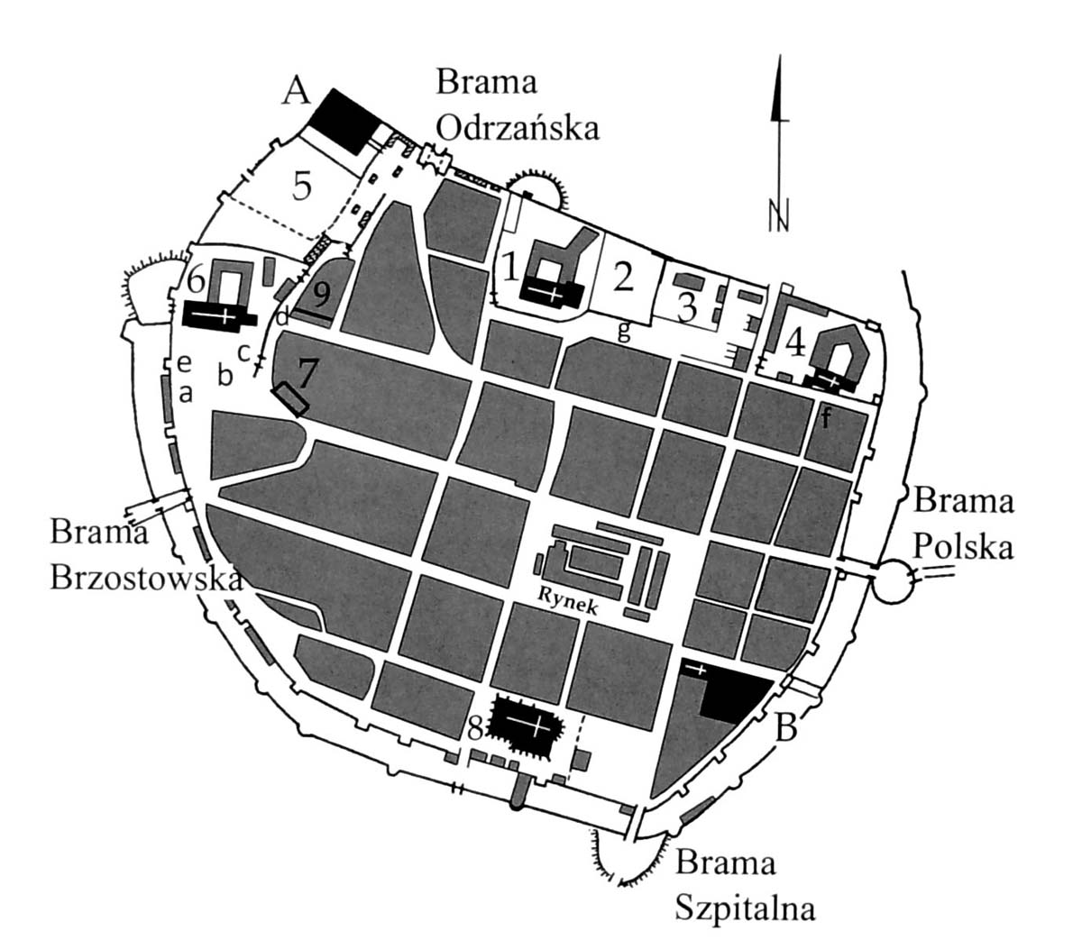
The brick fortifications of Głogów covered an area similar to an oval with a total area of about 20 hectares. The northern section, adjacent to the river, was relatively straight, while the southern corners were rounded. The north-western part of the town was the prince’s castle, connected to the town’s defensive walls. The fortifications were also adjacent to all the most important sacral buildings: a Dominican friary in the west, a Franciscan friary with a bishop’s court and a convent of Poor Clares in the north, and a parish church surrounded by a cemetery in the south. These buildings probably interrupted the underwall street running along the walls, surrounding the regular grid of the town’s buildings (yet in the 14th century, the outer parts of the town could have been empty, occupied by gardens by the walls). From the outside, in the north, the town had a narrow strip of land, about 50 meters wide, occupied by mills, warehouses, fulling mills, forges and warehouses (there were also mills floating on boats). On the other sides, in the late Middle Ages, on the outskirts of the town, by the roads leading to Głogów, the following suburbs developed: Brzostowskie, Szpitalne and Polskie. All of them were to be surrounded by fences, marking the area of municipal jurisdiction, but also treated as an auxiliary obstacle during sieges.
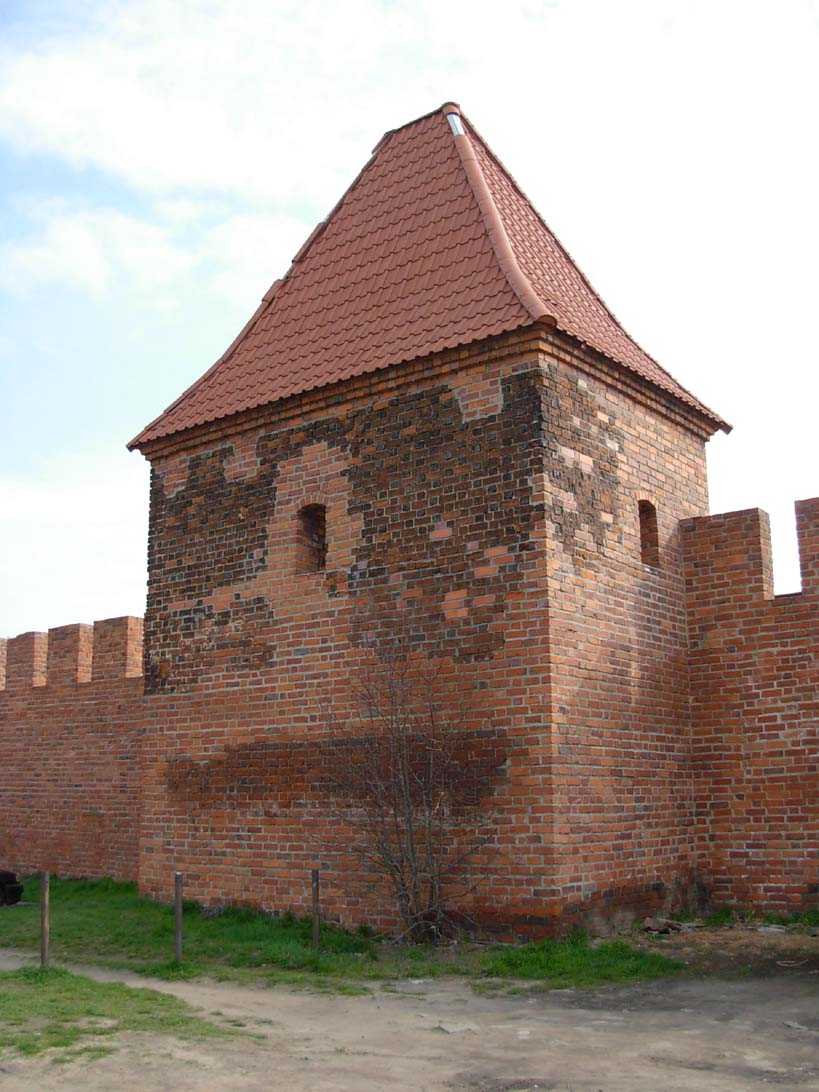
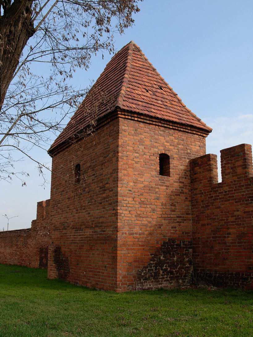
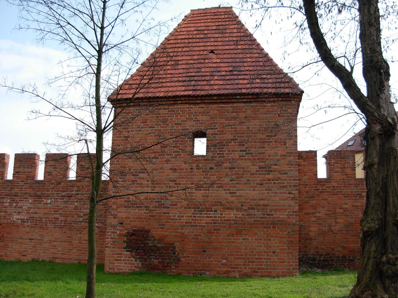
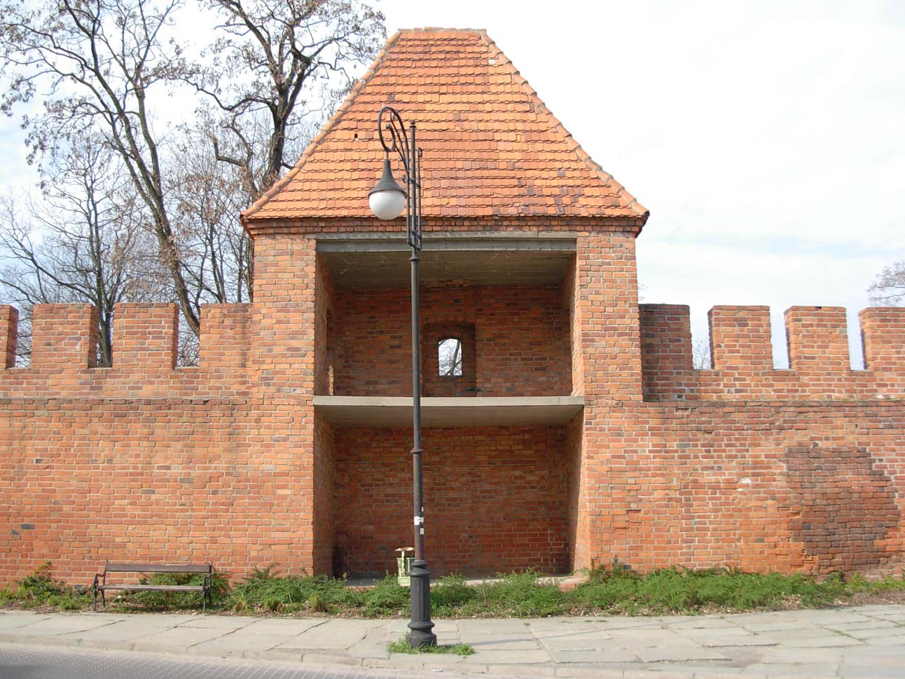
Wall was topped with battlements 1,2 meter high, and their thickness was about 1 meter. From the town side, it had a wall-walk on the offset, perhaps widened with a wooden porch. On the most endangered sections (except for the riverside side of the town) they were reinforced by half towers on a rectangular plan, divided into floors with wooden platforms. The towers were opened from the town side or sometimes, especially in a later period, closed with wooden or half-timbered walls. It reduced the construction costs and at the same time, in the case of conquering the town, it did not allow the enemy to use towers fully against defenders. The circuit of walls surrounding the town, had 17 half towers and 9 full towers. The outer defense zone was an irrigated moat.

A certain role in the defense of the town could also be played by monasteries and churches. Their advantage was that they were built quite quickly from durable materials, in contrast to timber residential buildings. Not without significance were also high church towers, which served as watchtowers and observation places. Defense assets could also be increased by the knight’s seats located in Głogów, built at strategically important points, sometimes as defensive homes. They were located mainly in the north-western part of the town, in the castle fief area. Other town structures, by contrast, weakened the defenses, for example a shoemaker’s house built on wall near Oder Gate. Non-permanent structures of this type were also found on the wall near the salt market and next to the Dominican friary. They were built quite early because in the fourteenth century, along with the increase in rent for the use of town plots. As such buildings significantly weakened the town’s defenses, they were certainly self destroyed during periods of danger.
In the first half of the fifteenth century Głogów was surrounded by the second ring of walls, with the exception of the northern section, adjacent to the high bank of the Oder River and the castle area, due to its powerful tower and an additional fortification system. The outer circumference was reinforced with 14 semicircular bastions, open from the town side and adapted to firearms. The largest of them, called Vighaus, was located in the vicinity of the parish church on the section between the Hospital Gate and the wicket gate of Saint John. It occupied the entire width of the zwinger, with the forehead protruding in front of the curtains to a similar extent as the other bastions.
To the town led from the south the Hospital Gate, from the east the Polish Gate and from the west the Brzostowska Gate. In front of it stood a hospital for lepers and a pit in the ground, where the condemned were cut and the carrion was thrown. The fourth of the main gates – The Oder Gate overlooked the river in the north-western part of the town, between the castle and the Franciscan friary. The four main gates were in the form of four-sided towers with passages (eg the Oder Gate) or gate passages were placed next to flanking towers (eg Brzostowska Gate). In the 15th and 16th centuries, gates were strengthened with foregates. The most fortified gate was Polish Gate, which in addition to the neck received a barbican, advanced far in the foreground.
The town was also communicated by several wickets or posterns. Hospital Gate led from a salt market to a leprosarium, at front of the postern gate of the Corpus Christi were town gardens, and the Mill Gate overlooked the north-east, next to the Poor Clares monastery. From the parish church to the cemetery a postern of St. John was opened. There was also a northern wicket gate in front of which the meadows and marshes spread out. In the second half of the fifteenth century, at the height of the Jewish quarter, the walls crossed the so-called Jewish wicket gate.
Current state
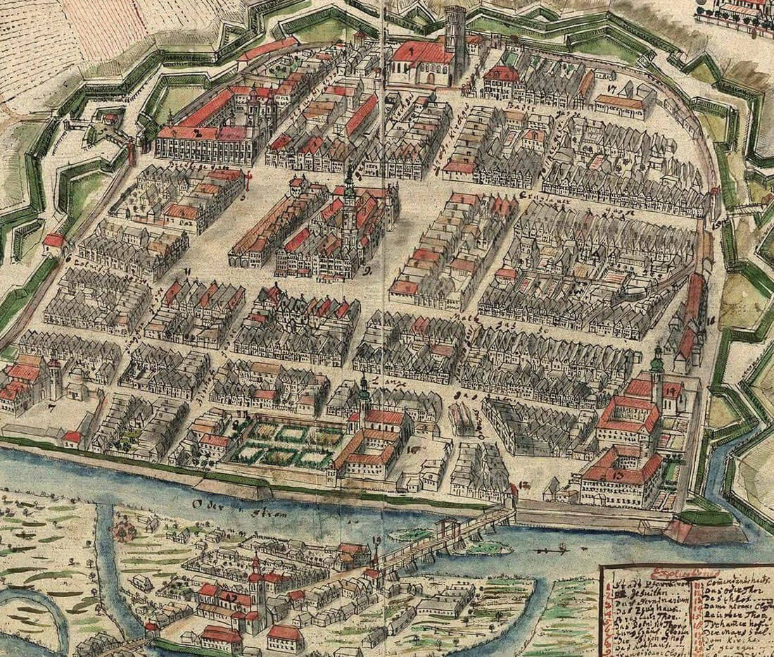
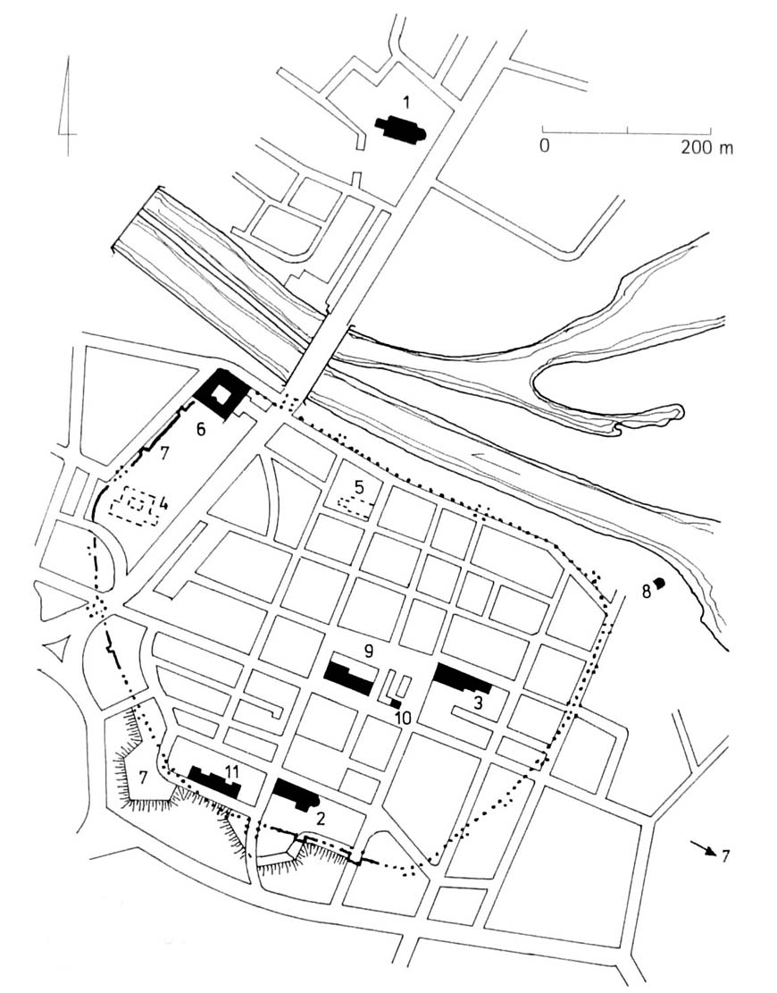
According to the descriptions of the town from the 16th century, Głogów was the second best fortified town in Silesia, right after Wrocław. To this day, only a few sections of the defensive walls with towers have survived from these strong fortifications, largely reconstructed in the post-war period. The best preserved fragments are located along Starowałowa Street (section of the wall with a single half-tower), on the western side of the former perimeter at Gołębia Street (reconstructed section of the wall with a single half-tower) and along the church of St. Nicholaus, between Rzeźnicza and Staromiejska streets (heavily rebuilt section of the wall without a finial, as well as one reconstructed half tower). Another section with relics of the wall reaching just above the ground level is located on the south-western side of the prince’s castle.
bibliography:
Adamska D., Rozwój przestrzenny lewobrzeżnego Głogowa od połowy XIII do początku XVI wieku w świetle źródeł pisanych [w:] Głogów, średniowieczne miasto nad Odrą, red. K.Czapla, Głogów 2018.
Nowakowski D., Elementy obronne średniowiecznego miasta i broń w mieście na przykładzie Głogowa w świetle źródeł pisanych i archeologicznych [w:] Głogów, średniowieczne miasto nad Odrą, red. K.Czapla, Głogów 2018.
Pilch J., Leksykon zabytków architektury Dolnego Śląska, Warszawa 2005.
Przyłęcki M., Budowle i zespoły obronne na Śląsku, Warszawa 1998.
Przyłęcki M., Miejskie fortyfikacje średniowieczne na Dolnym Śląsku. Ochrona, konserwacja i ekspozycja 1850 – 1980, Warszawa 1987.
Studia nad początkami i rozplanowaniem miast nad środkową Odrą i dolną Wartą (województwo zielonogórskie), red. Z.Kaczmarczyk, A.Wędzki, tom 2, Zielona Góra 1970.