
History
The first permanent settlements in the area of the later stronghold were established at the turn of the 8th and 9th centuries. In the 60s of the 9th century, they were replaced by a small stronghold situated in the headland, functioning together with the entire nearby complex of open settlements, placed at the intersection of trade routes connecting Wielkopolska with Silesia and Małopolska.
The original stronghold was replaced in the first half of the 10th century or in the middle of that century at the latest by a new, larger stronghold complex. The liquidation of the older, small hillfort took place not as a result of the armed conquest, but through social changes, probably supported by military pressure, which put Giecz in contrast to other important Wielkopolska settlements such as Poznań and Gniezno, which were burned down and built from scratch, not only significantly enlarged. This unusual fact was used to develop the theory that Giecz was the center from which the Piast dynasty took over the other strongholds of tribe of Polans. As if it wasn’t, the rebuilt stronghold created a strong center with a developed background, inscribed in the network of the main power centers of the emerging state.
During the first Piasts, Giecz secured important centers in Gniezno, Poznań and Ostrów Lednicki from the south, playing a role similar to that of the strongholds in Ląd and Łekno located in the north. For the first time in written sources it appeared in the chronicle of Anonymus called Gall from the beginning of the 12th century, who noted that Giecz was able to deploy 300 armored and 2,000 shield-bearers. The chronicler made a description of selected four strongholds, with Giecz ranked fourth after Poznań (1,300 armored and 4,000 shield-bearers) and Gniezno (1,500 armored and 5,000 shield-bearers), and on a par with Włocławek in terms of the number of shield-bearers. These numbers did not prove that hundreds of warriors were permanently in the stronghold, but that the stronghold district was able to mobilize a similar number of armed men. The Giecz stronghold was therefore perceived as an important military and administrative center.
In the 80s of the 10th century, a stone palace complex with a chapel-rotunda was built in the strongholds area. For unknown reasons, however, construction was stopped after the stone foundations had been laid. At the beginning of the 11th century, in the northern part of the hillfort, a stone church of St. John the Baptist, with architecture unprecedented in Poland, was built and expanded between the end of the 11th and 13th centuries. This expansion was probably carried out in connection with the reconstruction from the destruction caused by the invasion of prince Bretislav I of 1038. According to the Czech chronicler Kosmas, the stronghold’s garrison was to surrender without a fight, and the population was kidnapped and settled in Bohemia. When leaving Giecz, the Czechs burnt the remaining buildings.
In the second half of the 11th century, the stronghold was rebuilt and enlarged, which regained its place under the rule of Kazimierz the Restorer. Presumably, in the second half of the 11th century, it became the seat of a vast castellany. Unfortunately, in the first half of the 13th century, Giecz was damaged by the war between Władysław Odonic and Henryk the Bearded princes. Nevertheless, the stronghold still enjoyed great importance, as evidenced by the convention of the princes of Greater Poland, which took place here in 1253. It was not until the next century that the importance of the stronghold began to decline slowly. It was most likely related to the change in the course of trade routes and the emergence of new urban centers in the vicinity. Probably at the beginning of the fourteenth century, perhaps due to the Teutonic Knights invasion, the stronghold was abandoned.

Architecture
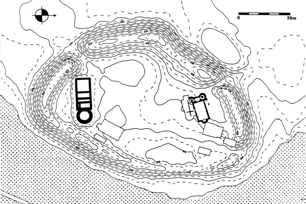
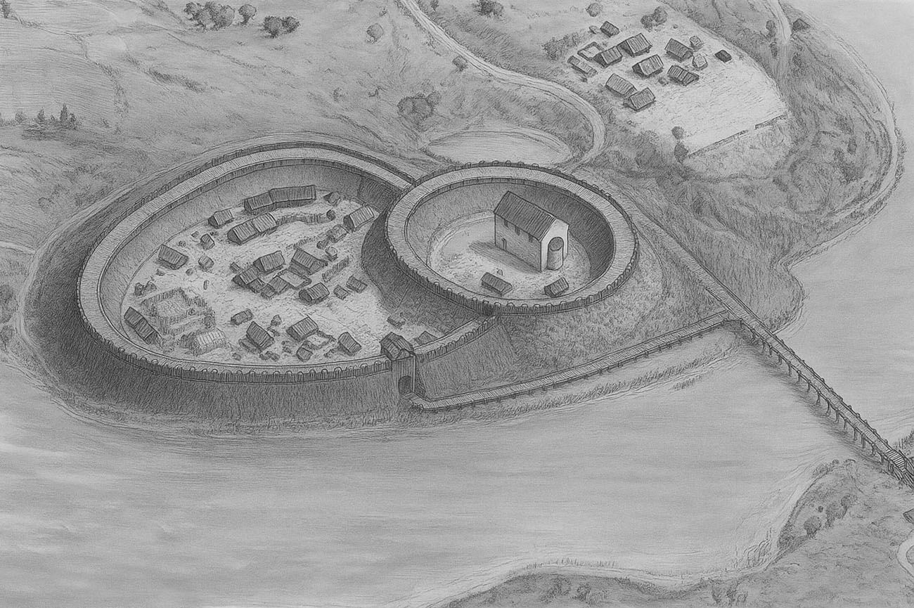
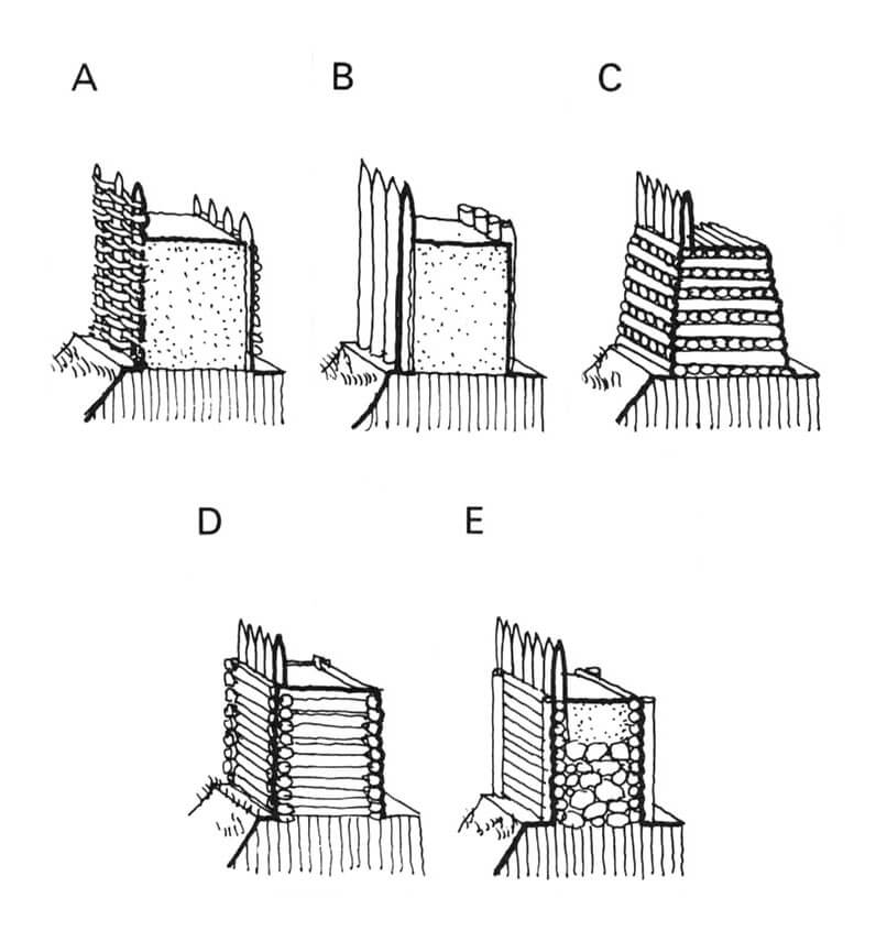
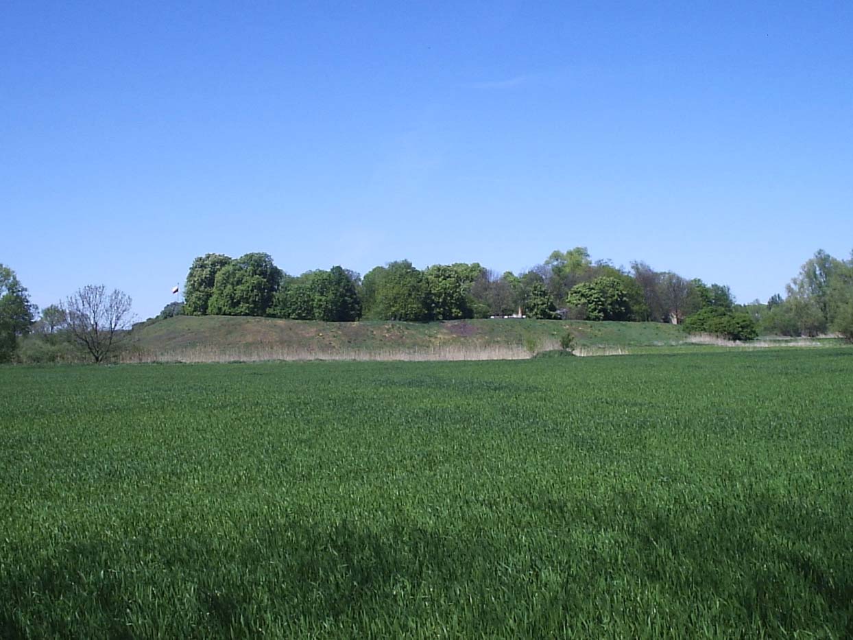
The stronghold was established on the western edge of the Moskawa valley, which once formed a pool in the form of a long and narrow lake. It was situated on on a peninsula surrounded on three sides by waters. It was probably separated from the south-west side, which was accessible by land, by a moat. In the 60s of the 9th century, stronghold occupied the northern part of the later foundation, occupying a circle or ellipse with an internal diameter of about 45 meters. Its ramparts were about 12 meters wide at the base and were filled with a wooden grate to strengthen the structure. Perhaps the stronghold was connected to the opposite shore of the lake by a wooden bridge. During this period, there was also an older market settlement on the eastern side of the lake and an open settlement to the south-west of the stronghold, located on the edge of the lake, right next to the Moskva river bed, identified with a river crossing. From the north, in the area adjacent to the stronghold, a sacral-cult building was probably erected, which continued to function in the 10th century, when a cemetery developed there.
In the second quarter of the 10th century, the Giecz stronghold was significantly enlarged, to the plan of an oval with dimensions of about 200 x 140 meters. As a result of the reconstruction, the ramparts of the oldest part of the stronghold were strengthened, widened and covered with stones, and from the south it were surrounded by a wooden and earth shaft, 16 meters thick at the base. It was erected from several piles of a grate structure, with the lowest parts being reinforced by a hooks. Moreover, the rampart of the southern part of the stronghold was stabilized by a 3-meter-wide wooden and earth offset adjacent to it from the outside. From the outside and inside, it was bordered by single rows of vertical piles deeply driven into the ground. In this way, a two-part stronghold was created with a clearly separated ducal part.
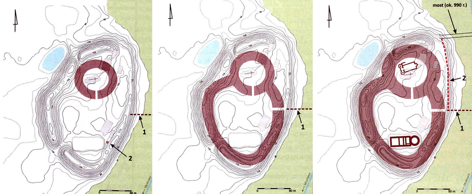
In the second half of the 10th century, the area of the hillfort was enlarged by moving the inner face by about 2 meters towards the core of the rampart, and the outer face by about 6 meters towards the lake, thus widening the base of the shaft to about 21 meters. The defensive zone of the ramparts of this phase was complemented by rows of piles diagonally driven into the coastal part of the lake. At that time, the castle gate was probably located in the eastern part of the southern fortifications. Placing the only entrance from the lake side, to which an exposed pier running several meters along the ramparts would lead, and then a bridge over the lake, would additionally strengthen the stronghold’s defense. The bridge itself, located then on the north-eastern side, was about 6 meters wide, so it allowed for two-way traffic.
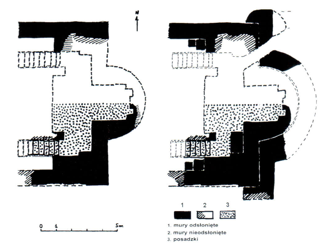
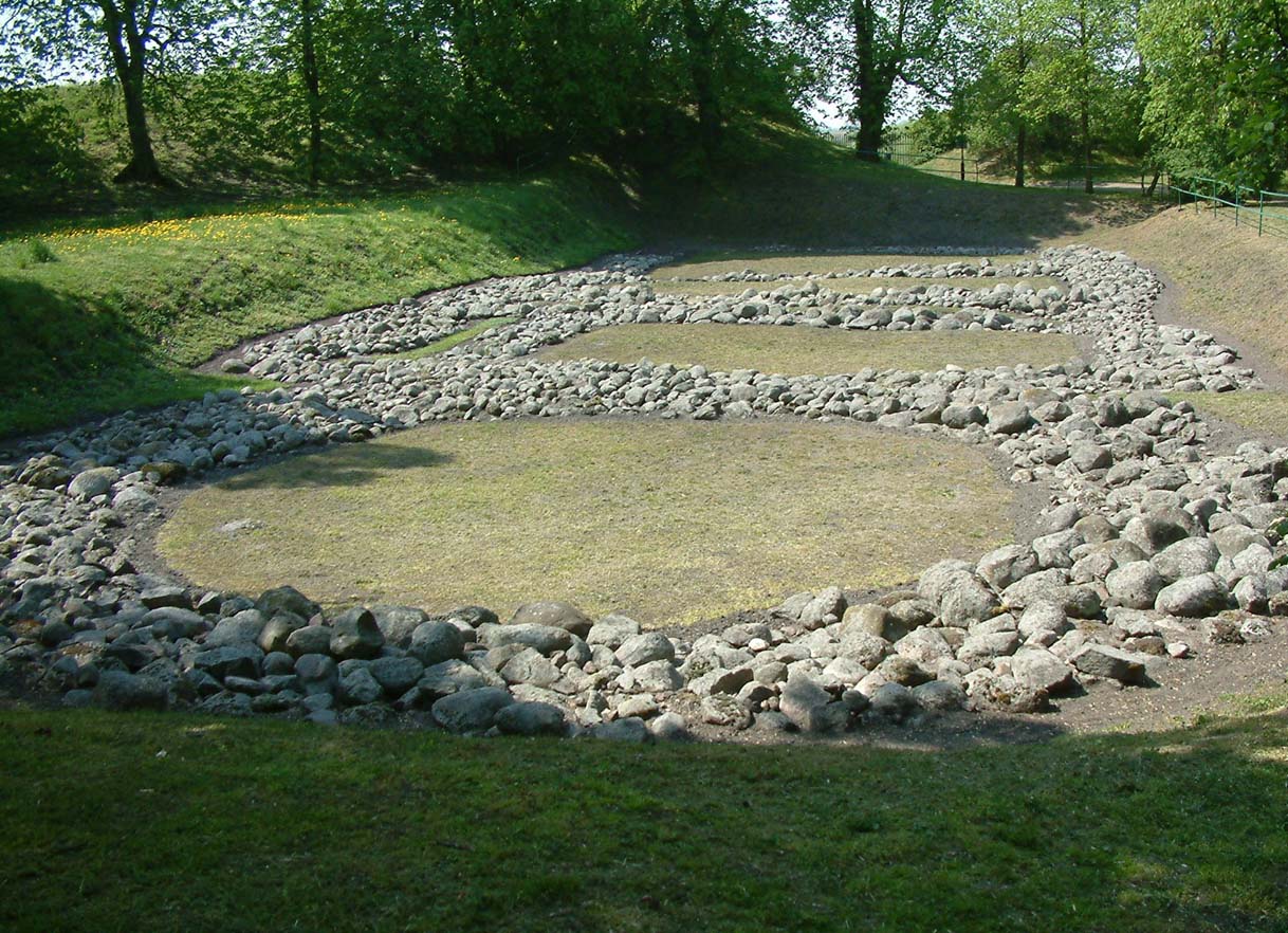
At the end of the 10th century, in the southern part of the stronghold, the construction of a stone palas began on the plan of an elongated rectangle divided internally into five rooms of different sizes. On the eastern side, this part bordered the chapel – a rotunda on a circular plan. The entire complex was to be 47 meters long, including the palace part – 35 meters. The width of the palas and the diameter of the rotunda was 16 meters. They were erected of large erratic stones, bonded with greasy clay mortar, but for unknown reasons, no stone walls were ever erected above the foundation part, although a wooden structure was probably erected on the site of the chapel in the first half of the 11th century. The remaining southern part of the stronghold, previously intended for palace buildings, was filled with residential buildings. The transverse rampart separating the northern and southern parts of the stronghold was most probably demolished at the end of the 13th century, making Giecz once again a single-section structure.
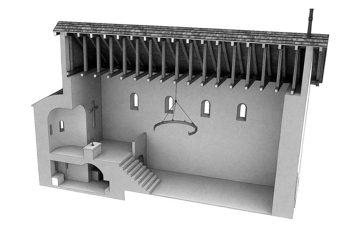
St. John’s Church was built in the early 11th century in the northern part of the stronghold, using large erratic stones bonded with greasy clay. The walls were constructed using the opus emplectum technique, with the outer wall constructed of irregularly shaped stones, carefully hewn from the face. In first phase, it was an aisleless structure, terminating on the eastern side with a semicircular apse, adjoining without a setback, and on the western side with a straight wall. The nave was approximately 21.5 meters long and 12 meters wide, while the apse was circular in plan with a diameter of 2.5 meters. The ground-floor walls, supported by a shallow plinth, were approximately 1 meter thick. The entrance was likely located in the western wall of the nave. The builders also intended to construct an elongated, rectangular annex against the northern wall of the nave, but this project was never completed.
An interesting and unique element of the building in Poland was the underground reliquary crypt of an unknown saint, located under the presbytery. It consisted of a rectangular, almost square chamber to which led two 7-step, narrow (about 1 meter wide) passages, symmetrically placed on both sides of the choir stairs. They turned at right angles towards the crypt interior, connecting with a wider chamber, measuring 5 x 2.5 meters, oriented perpendicular to the church axis. A rectangular recess, approximately 2.5 meters long, was located in its western wall at a height of 0.4 meters. On the eastern side, the chamber was adjoined by a nearly square room, 2.5 x 2.5 meters, fitted into the apse, with two or three shallow niches. The room’s wall springing seamlessly into a vault, reaching a height of approximately 3.3 meters. The crypt was lowered from the nave floor by about 1.2 meters, and its floor was made of a gray-yellow lime mortar. The walls were plastered, the passages with stairs were vaulted, and the two entrances containing the stairs were topped with arcades and closed by doors mounted on iron hinges. Thanks to the crypt, the level of the chancel was raised 2.5 meters above the nave.
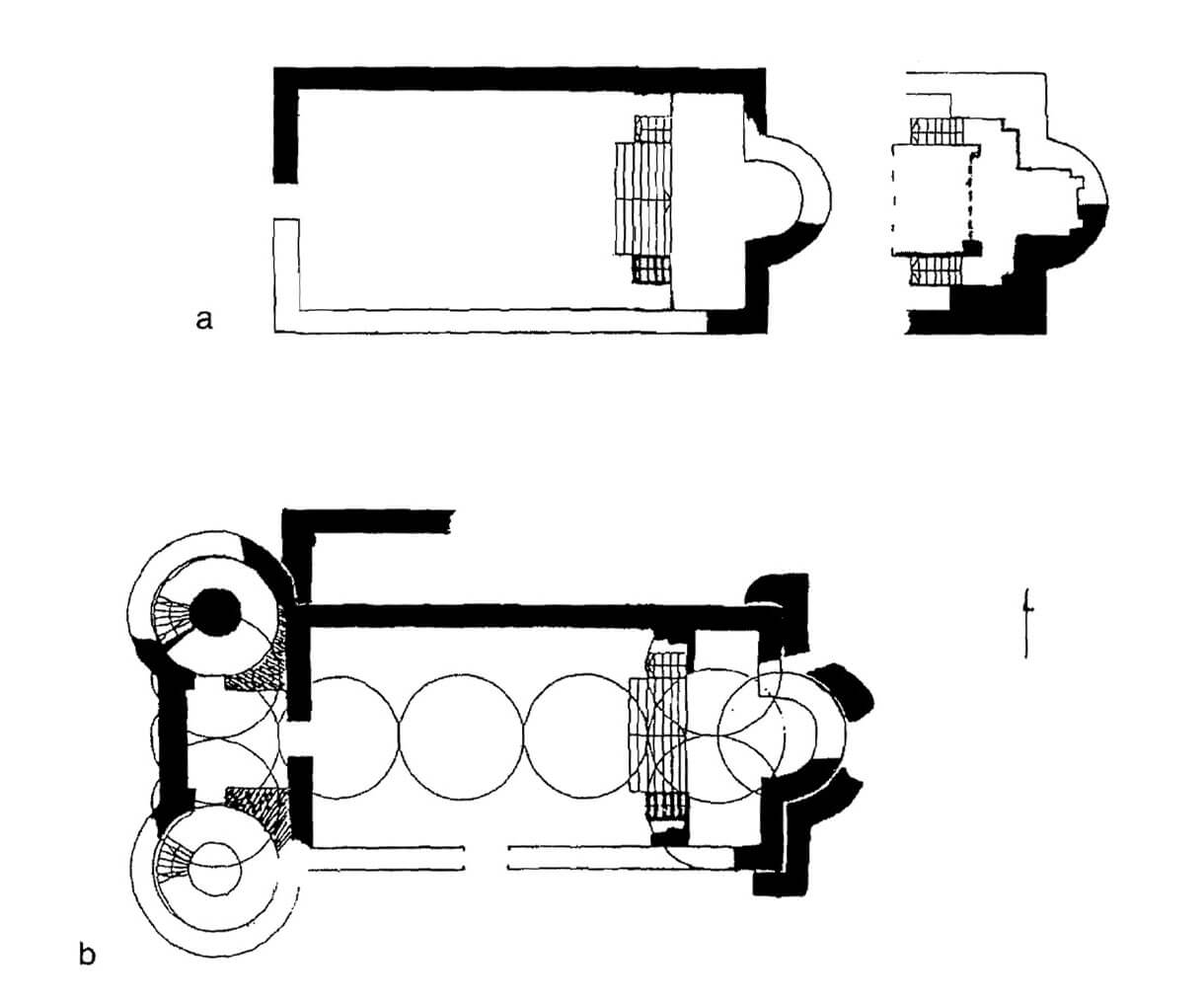
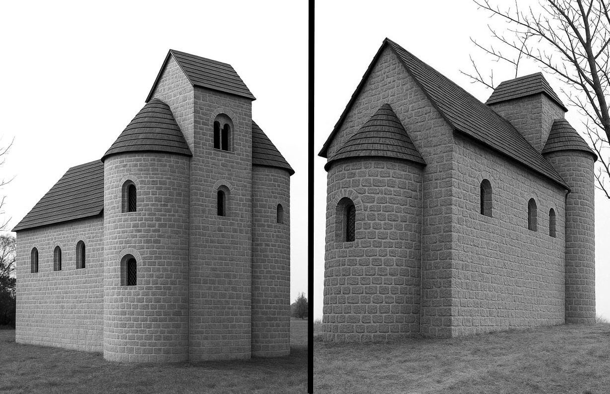
Later, between the end of the 12th and 13th centuries, a westwork inspired by Ottonian architecture was added to the church: two towers and a square inter-tower block measuring 4 x 3.7 meters. The towers had a diameter of 6.5 meters and housed spiral staircases 1.2 meters wide each. The whole structure was built in the opus incaertum technique of carefully selected flat stone slabs, bonded with gypsum mortar. The only entrance to the westwork led from the side of the nave through a doorway located on the axis of the church. During the reconstruction, a wall was also created at the north-west corner of the nave, probably being an element of an unfinished annex or an attempt to expand the church into a three-aisle basilica. The eastern part of the church was also expanded, surrounded from the outside, including the apse, with a closely adjacent wall, about 1.6 meters wide. At the same time, the entrance to the northern passage of the crypt was pierced from the outside, allowing entry to it bypassing the nave of the church. The entrance was 2 meters high, only 0.8 meters wide and topped with a semicircle. A very original solution for the underground part of this entrance was to limit the space not with stone walls, but with wooden formwork of the wall and ceiling.
Current state
Today in Giecz, one of the central hillforts of early medieval Poland, an archaeological reserve is established. Its most important elements are: fortified settlement with an area of approx. 3,6 ha with earth ramparts having a base of approx. 30 meters and reaching up to 9 meters in height and foundations of a palatium. In the former outer bailey, it is worth seeing the fully preserved Romanesque church of the Assumption of the Blessed Virgin Mary and St. Nicholas. In the museum you can visit an exhibition presenting the history of the city and castellany of Giecz, as well as the most important archaeological monuments excavated during archaeological research in the city and neighboring sites. In 2011, an educational settlement was also opened. Ticket prices and opening hours can be checked on the official website of the museum here.
bibliography:
Gród piastowski w Gieczu. Geneza, funkcja, kontekst, red. M.Kara, T.Krysztofiak, A.Wyrwa, Poznań 2016.
Krzysztofiak T., Wczesnopiastowski kościół pw. św. Jana Chrzciciela na grodzie w Gieczu w świetle najnowszych odkryć [in:] Początki architektury monumentalnej w Polsce, red. Janiak T., Stryniak D., Gniezno 2004.
Olejniczak K., Grody i zamki w Wielkopolsce, Poznań 1993.
Rodzińska-Chorąży T., Iuxta preceptum episcopi grandem fossam fecerunt – czyli o męczennikach, klasztorach, zakonnicach i Gieczu słów kilka [w:] Architektura średniowieczna i archeologia – konteksty, Wrocław 2024.
Rodzińska-Chorąży T., Krypta kościoła grodowego pod wezwaniem świętego Jana Chrzciciela w Gieczu – analiza formy i funkcji [in:] Magistro et Amico. Księga Pamiątkowa dedykowana prof. Lechowi Kalinowskiemu, Kraków 2000.
Świechowski Z., Architektura romańska w Polsce, Warszawa 2000.
Tomala J., Murowana architektura romańska i gotycka w Wielkopolsce, tom 1, architektura sakralna, Kalisz 2007.
Wyrwa A.M., Gdecz-Giecz. Scire est reminisci, Dziekanowice-Lednica 2014.