

History
The first wood and earth fortifications were built in Elbląg shortly after the town was founded in 1237. The construction of brick fortifications, intended to replace the fortifications on earlier, the same circuit, began in the eighties of the thirteenth century. After the break caused by the fire in 1288, the works resumed in the nineties. At that time, the construction of the town gates: Market, Blacksmith and Castle, as well as the north and east side of the walls, were started. In 1319 the construction of the Market Gate was completed, and in 1322 the Castle Gate was rebuilt. Reconstruction of the western part of the walls began at the latest, because only in the years 1336-1341. Until 1335, this side of the town was defended by a wooden palisade. As for the southern side, the Teutonic Knights forbade the construction of town fortifications in this section. The southern part, as was in the location privilege, was excluded from the fortification system and put under protection of the Teutonic castle.
At the beginning of the fifteenth century, the town walls were in a very bad condition. The moat between the Old Town and the New Town was completely covered with trash and muck, and the wall between the Market Gate and the river in 1409 collapsed. The defeat of the Order at Grunwald and the fear of invasion by Polish and Lithuanian armies caused that the Teutonic Knights were again interested in strengthening the Elbląg fortifications. In the years 1410-1437, a second circuit of walls was built from the east and north, 1000 meters long, with two gates: Blacksmith and Market, 9 cylindrical towers and an external moat powered by a stream which does not exist at present. Along with the expansion of the Elbląg fortifications in 1417, a new defense system was created. It consisted in dividing the town into four quarters with designated sections of walls for defense and conservation. At the head of each of them were two elders from the town council and four elders selected from townsmen living in a given quarter. Along with the inhabitants, Elbląg’s guilds were designated for defense activities.
From the second half of the fifteenth century until the sixteenth century there were no more visible changes in the town fortifications. Only at the turn of the fifteenth and sixteenth century before the Market Gate, over the first moat was built a fortified stone bridge. The repulsion of the Teutonic attack in 1521 and the fear of an attack on Prussia by Moscow and Sweden caused that in 1549 the Polish king Zygmunt August released the town from paying tax, and this money was allocated for fortification works. In 1553, the earth rampart was widened and once again from the outer Market Gate to the river, and the outer, northern moat was expanded. Probably in connection with these works in 1554 the ruins of the Teutonic castle were finally demolished. The end of the sixteenth and seventeenth centuries brought modernization of the fortifications of Elbląg through the construction of bastion fortifications. In the 18th and 19th centuries, the medieval town walls were pulled down and the moat was filled up.

Architecture
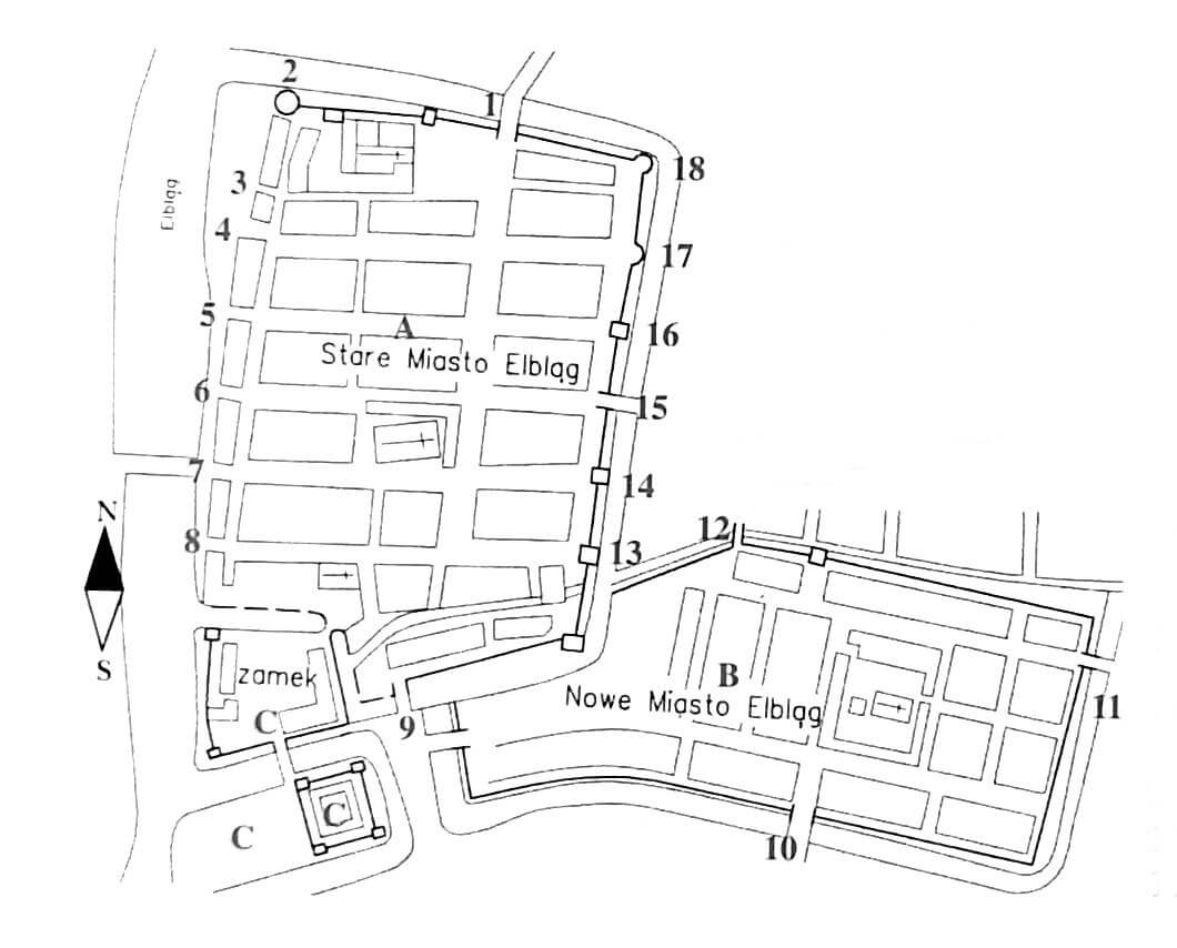
The town walls were built on the plan of an elongated quadrangle situated the longer side along the Elbląg River, which protected the town from the west. The Hundebeke stream flowed towards it from the north-east forests, and the small river Kumiela (Hommel) flowed south-west, where it ran into the Elbląg River behind the Teutonic castle. In the first half of the 13th century, from Kumiela a canal was dug, which, flowing parallel to the Mill’s Dike, supplied water to the town and castle moats, and then to flowed to the Elbląg River between the castle and the town fortifications.
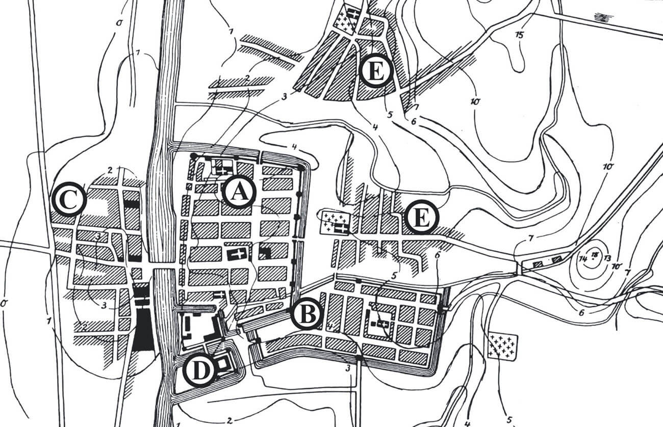
The south-west corner of the Elbląg was formed by the outer bailey of the Teutonic Knights castle, separated from the town, in front of which there was the hospital of Holy Ghost. The north-west corner was occupied by the Dominican friary complex, placed inside the fortifications. Since 1335-1341, the Old Town was adjacent to the New Town of Elbląg, located in the south-east. Moreover, in the Middle Ages, from the east and north-east, the foreground of the town was occupied by two unwalled suburbs. The role of the suburbs had also the Granary Island, where buildings related to sea trade were located (storage yards, gardens, granaries, shipyard and port facilities as well as various warehouses and workshops). Inside the fortifications, the town was made up of regular blocks of buildings and a network of streets, without a separate market square, the function of which was served by the main street running along the north-south axis, crossing the roads leading to the gates on the river. Except for the more developed west side, Elbląg had an underwall street.

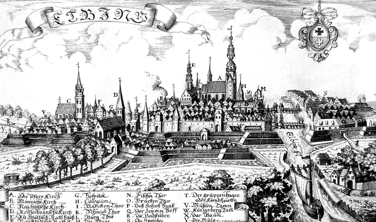
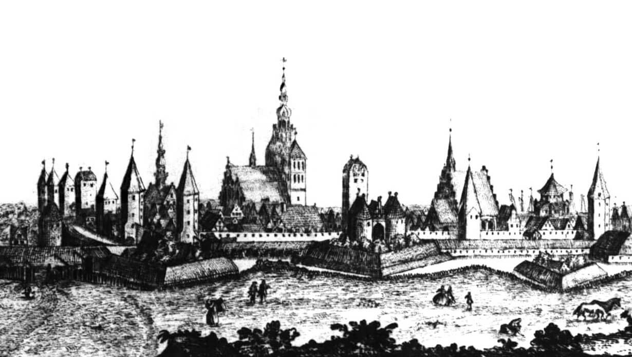
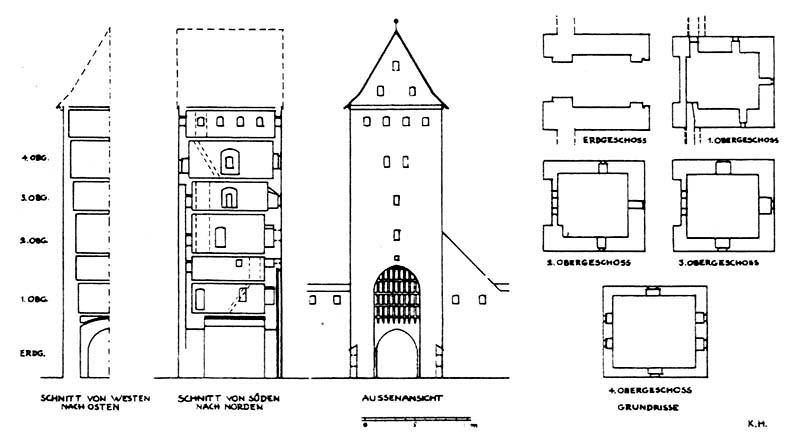
The town walls in their final form had a length of 1700 meters and a height of about 8 meters, and were surrounded by an irrigated moat. They closed the area of 15 ha, and 22 ha after moving the town border to the west in 1326 (until this period, only timber and earth fortifications operated at the riverfront). This system also included 10 towers and 9 gates. The Elbląg towers were built mainly on the street extension, they were 10 to 12 meters wide and 22 to 28 meters high. Most of them had the shape of a quadrangle, only the Monk Tower was built on a cylindrical plan. Initially they did not have a roofs and were usually opened from the town side. After raising, the upper parts of the towers were often made on an octagonal plan. The towers were placed relatively regular around the perimeter, with the exception of the safe western section of the riverside and the southern side protected by the castle. Their partial projection in the foreground, in front of the face of the walls, provided the possibility of side firing. The curtains in the late Middle Ages were topped with a covered wall-walk, with a full parapet in which a row of arrowslits was pierced.
The southern side of the town was defended by the weakest fortified Castle Gate. In the south-east corner of the walls, the Groman’s Tower was built, another was New Tower, also called Bow Tower. Behind it, towards the north, there was a small half tower, and then the Detention Tower, also known as Dungeon or Thieves Tower. Behind Detention Tower, another small half tower was built. Next was the Blacksmith’s Gate, erected in the center of the eastern wall. Further north of the Blacksmith’s Gate there was the Burghers Tower, Tanners Tower and in the north-eastern corner Heretics Tower. From the north side the Market Gate was located. There were two towers between it and the Elbląg river: Shooting Tower (also called the Little Monk) and the Monk Tower (also known as the Great Monk). The latter was the only one in the plan to have a cylindrical form, while the name was due to the nearby Dominican friary.
From the side of the river, five gates were built for the sake of the big traffic between the town and the waterfront. Counting from the south, these were the gates: Holy Ghost Gate (later known as Barley), Bridge Gate (leading to High Bridge, also known as Koga Bridge), Fish Gate, Cooper Gate (also called Crane), Tobias (or the Scale Gate) and further on the Dominican monastery, the smallest wicket Monk Gate.
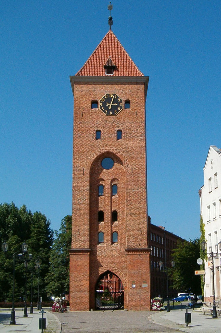
The Blacksmith’s Gate and the Market Gate were the most important elements in the entire defense system of medieval Elbląg, thanks to which in the 15th century they were already about 26 meters high. The Market Gate finally gained as many as seven floors, with a gate passage in the ground floor, closed by a portcullis lowered in a high, pointed recess. The individual storeys were separated by timber ceilings, and illuminated by small, semi-circular and segmental crowned windows and slit loop holes. Between the gates on the outer side of the walls on the north and east sides, there was a strip of free space (berm) reaching the irrigated moat. In front of the Market Gate, in the late Middle Ages, there was probably also a foregate with two cylindrical towers, facing the suburb with a fulling mill, a tannery and a brickyard.
The outer defensive wall formed in the years 1410-1437, built on the most endangered north and east sides, had nine cylindrical towers and two gates: Smiths and Market, situated on the extension of the gates of the main circuit with the same names. From among the towers the northern corner one was called On an Acute Corner. The outer gatehouse was also built in front of the southern Castle Gate at that time. The second defensive circuit was preceded by another moat, in the north-west connected with the Elbląg River, and in the south-east, reaching the fortifications of the New Town.
On the southern side, the town and the Teutonic castle were separated by the Kumiela stream canal, supplying the town and castle moats with water, and then flowing into the Elbląg River. In the south-east, canal played the same role in relation to the New Town of Elbląg. Its fortifications were established on a plan similar to a rectangle measuring 215 x 430 meters. They were not equipped with towers, it probably didn’t even had brick curtains, but only four gatehouses, one on each side of the world: Castle Gate from the west, Malbork Gate from the south, overlooking the fishing village of Osiek, Pasłęk Gate on the east and James’s Gate in the north curtain. The latter was directed to the suburb centered around the church of St. James, the hospital and the chapel of St. Elisabeth and mills on the river Kumiela, squeezed between both cities of Elbląg.
Current state
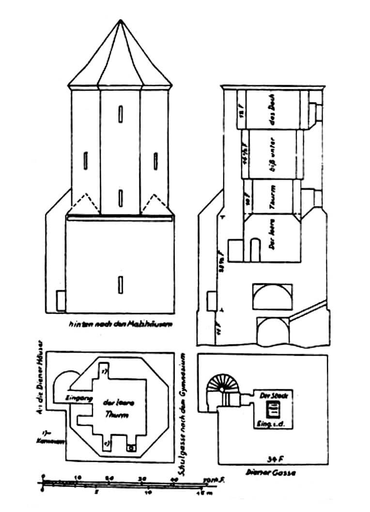
To date, only the Market Gate survived from the medieval fortifications of Elbląg. It is one of the most characteristic and recognizable monuments of the town. After renovation carried out in 2006, an observation deck from which you can admire the panorama of the Elbląg Old Town, was created. The gate is open to visitors from May to September, then the Tourist Information Center operates in gate.

bibliography:
Atlas historyczny miast polskich. Tom 1 Prusy Królewskie i Warmia, red. A.Czacharowski, zeszyt 1 Elbląg, Toruń 1993.
Nawrolska G., Rozwój przestrzenny Elbląga w średniowieczu i okresie wczesnonowożytnym, “Archaeologia Historica Polona”, tom 23, 2015.
Sypek A., Sypek.R., Zamki i obiekty warowne Warmii i Mazur, Warszawa 2008.