
History
In 1250, Dobiegniew was given to the Cistercian nunnery in Owińska by the Prince of Wielkopolska, Przemysł I, which was confirmed by Przemysł II in 1280. Although in 1296 the settlement passed into the possession of the Brandenburg margraves, the Cistercian nuns had an influence on local affairs for a long time and it was their efforts that the market settlement could be transformed into a regularly planned town in the second half of the 13th century. A document from 1250 was the first written record of Dobiegniew, then called Dobegneve (the German name Waldinborg, then Woldenberg, began to appear only in the 14th century).
The town walls in Dobiegniew were built in the first half of the 14th century, on the site of earlier wood and earth fortifications. In 1313, fortifications were first recorded in documents, although this record probably did not apply to brick walls. In 1336, the parish church was already recorded as being located “intra muros”, but construction work had to be continued, because in 1340 the townspeople obtained a two-year tax exemption from the margrave in order to enable the town to be closed with a wall and surrounded by a ditch. The ruler of the New March was vitally interested in securing the town, which was threatened by revindication action of Poland.
In 1326 the town, not yet fully surrounded by walls, suffered during the raid of Polish army. In 1417 Dobiegniew, since the beginning of the 15th century under the rule of the Teutonic Knights, was ravaged by fire, which made the town weak at the beginning of the Polish-Teutonic wars. In 1433, the town walls of Dobiegniew had to repel the invasion of the Hussite army, supporting the Poles in the war with the Teutonic Knights. It failed the invaders, which led to further destructions. In 1454, the New March was sold by the Teutonic Knights to the Margrave of Brandenburg, during which in 1467 the rebellious mercenary army attempted to capture the town. In 1486 it was again on fire, although probably with less devastating effects.
In the early modern period, Dobiegniew’s defensive walls were damaged during the Thirty Years’ War, during which began to become obsolete. The fire of 1641 was especially devastating for the town. In later early modern times, starting from the 18th and 19th centuries, the fortifications, due to their uselessness due to the development of artillery, began to be gradually dismantled. Even at the beginning of the 18th century, the defensive perimeter was practically full, but by the end of the 19th century it had almost completely vanish.
Architecture
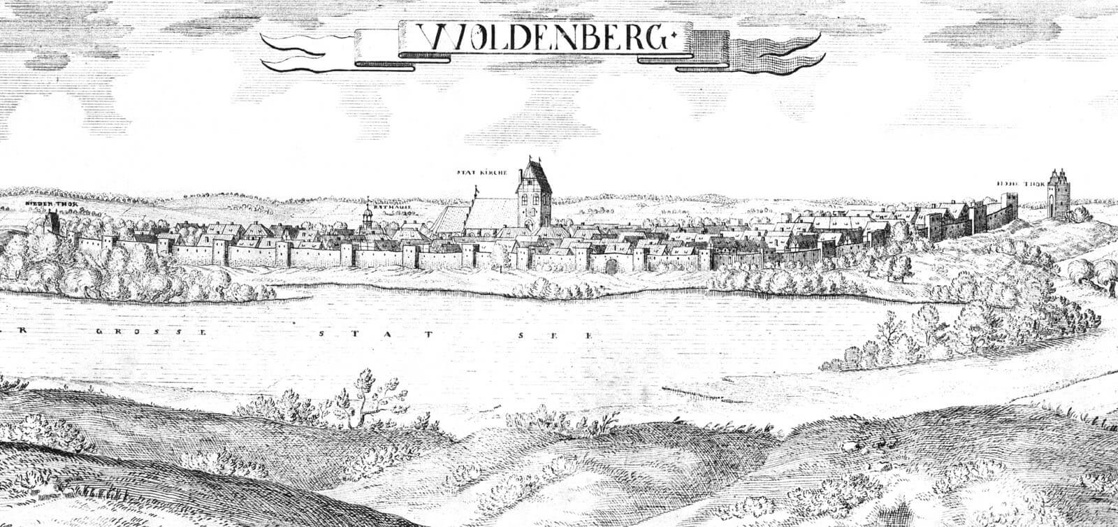
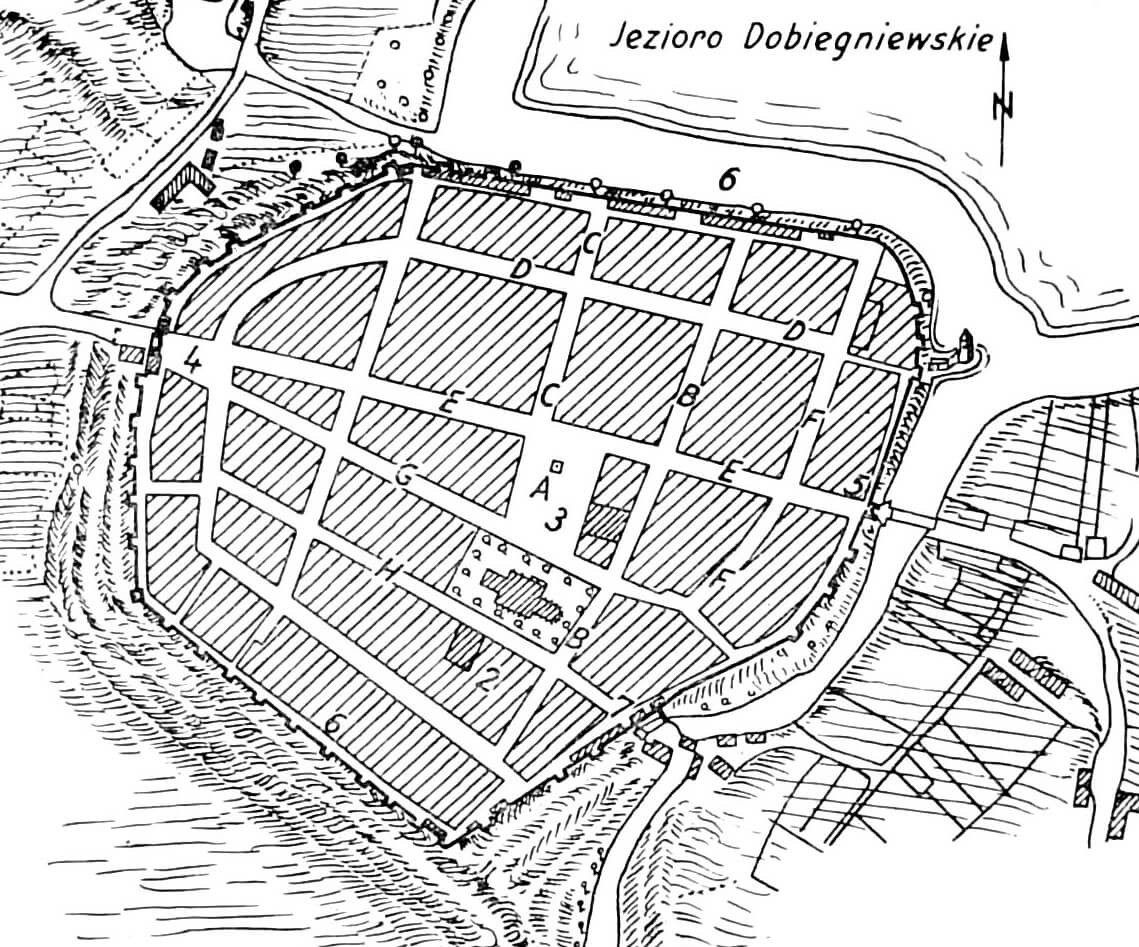
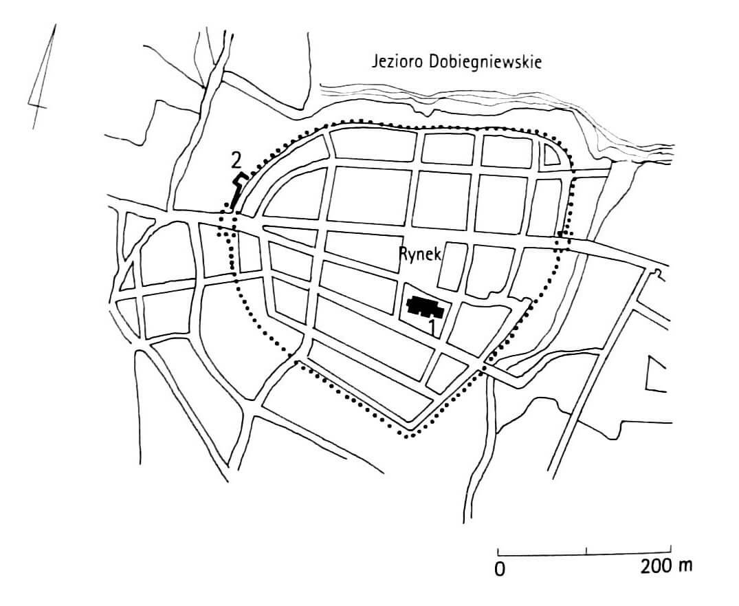
The town developed on the southern side of Lake Wielgie, on a terrace overlooking it, and at the same time on the western side of the Mierzęcka Struga flowing into it. On the west side there were other smaller and larger water reservoirs, which left a passage about two kilometers wide in front of Lake Wielgi on the north-western side of the town. The surrounding areas were also characterized by heavy forestation, especially in the south and north along the Drawa River. The area of the city rose gently but significantly to the west.
The perimeter of the fortifications had the shape of an irregular hexagon, defined by a ring of a single line of the defensive wall and a ditch. It was built of Gothic bricka in the monk bond, connected with lime mortar, on a stone foundation and a plinth. Probably at the end of the Middle Ages, the curtains were protected with a straight parapet with a pierced row of arrowslits.
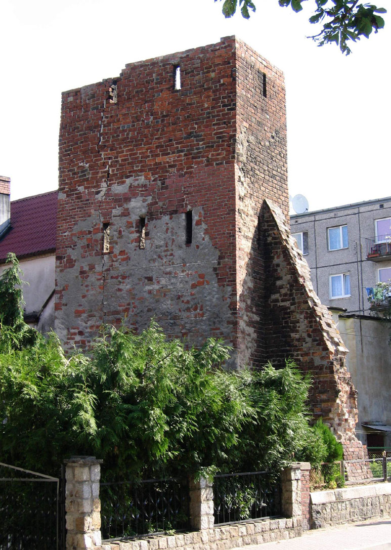
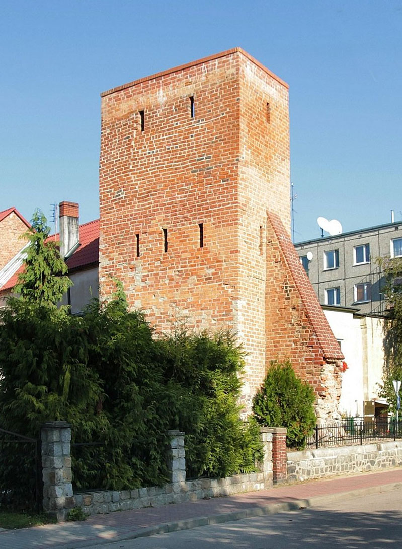
The walls were reinforced with about 37 half towers located on each side, with the exception of the safest northern part. In addition, in the south-west corner there was a tower erected on a quadrilateral plan, changing into a cylindrical superstructure. The half towers were erected on a rectangular plan, without brick internal (rear) walls. It were divided into floors, connected by brick staircases. In addition to the warehouse high ground floor, there were two more combat floors: one at the level of the adjacent wall-walks in the curtains, the other one storey higher. Loop holes were placed in them, embedded in recesses with stepped and segmental heads. The height of the half towers was about 8 meters.
In the length of the defensive circuit there were two gates: Upper (High) from the west, facing the road to Strzelce Krajeńskie and Barlinek, and Lower (Short) from the east, facing the road to Wałcz and then Bydgoszcz or Koszalin, as well as two posterns: Water Gate, facilitating access to the lake, and Mill Gate located on the river. Both main gates probably had the form of a four-sided buildings with passages in the ground floor, covered with roofs based on Gothic gables.
Current state
The best element of fortifications preserved to this day is the half tower at the junction of Zabytkowa and Wyszyński streets. Recently it has been renovated, the façades have been cleaned and cavities have been supplemented.
bibliography:
Jarzewicz J., Gotycka architektura Nowej Marchii, Poznań 2000.
Kowalski S., Zabytki architektury województwa lubuskiego, Zielona Góra 2010.
Pilch J., Kowalski S., Leksykon zabytków Pomorza Zachodniego i ziemi lubuskiej, Warszawa 2012.
Studia nad początkami i rozplanowaniem miast nad środkową Odrą i dolną Wartą (województwo zielonogórskie), red. Z.Kaczmarczyk, A.Wędzki, tom 1, Zielona Góra 1967.