
History
The construction of the town walls in Debrzno (Preußisch Friedland, Frydląd), one of the southernmost centers of the Teutonic Knights state, was carried out in the second half of the 14th century. Works certainly started after 1354, when the order granted the town a foundation privilege. The walls were probably erected in one stage and were not later subjected to significant modifications (e.g. raising, changing the course of the curtains).
In 1433, Dębrzno, probably not defended, was ravaged by the combined Polish-Hussite army heading for Gdańsk. At the outbreak of the Thirteen Years’ War, upon hearing of the fall of the Teutonic castle in Człuchów, the townspeople of Dębrzno joined the rebels, but soon after they surrendered to the commander of Człuchów, who returned with reinforcements from New March. The Teutonic Knights did not place a garrison in Debrzno, which made the townspeople change sides of the conflict after hearing about the successful defense of the Człuchów castle against the Teutonic counteroffensive. This time, Włodko from Donabórz, the starost of Nakło, was supposed to garrison Debrzno. On the side of Poland and the Union, the townspeople persevered until 1455, when the Teutonic Knights mercenaries stood near Debrzno. The faith of the defenders in the town fortifications was not too great, because they capitulated without a fight. The assault on Debrzno took place only in 1461, during the expedition of starost Piotr from Szamotuły to the garrison of Teutonic mercenaries led by Kaspar von Nostitz. The mercenaries surrendered and withdrew, but at the beginning of the following year they recapture Debrzno. Eventually, the Teutonic garrison capitulated without a fight at the end of the war.
In 1466, after the II Peace of Toruń, Debrzno was incorporated by king Kazimierz Jagiellończyk into the Poland, which resulted in the loss of its military significance. As a consequence, from the end of the Middle Ages, information in documents about the town fortifications was rarely provided. Already in the mid-sixteenth century, the town gates were said to be left open at night, which would mean that either the townspeople felt extremely safe, or the gates were in such a bad condition that had no doors. It is known that during wars and other natural disasters the town suffered numerous losses in buildings, and the walls also had to be destroyed. Medieval fortifications probably completely lost their importance with the development of firearms and siege art in the 17th/18th centuries. Walls took part in military operations for the last time in 1627, when Swedish mercenaries attacked a town defended by Polish reiters. The last major repairs of the fortifications were to be carried out at the beginning of the 18th century.
In the mid-nineteenth century, there were no walls on the eastern and southern sides, and only a fragment of fortifications was located on the northern side. In the second half of the 19th century, subsequent parts of the walls were demolished along with all the gates. In 1899, the town council applied for the demolition of the last preserved elements of the fortifications, but the application was rejected by government institutions. Thanks to this, at the beginning of the 20th century, the historic remains of the walls were renovated.
Architecture
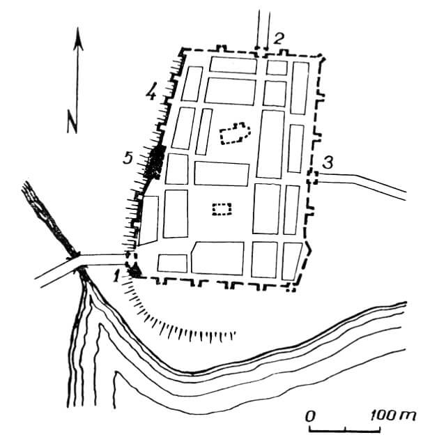
The town was founded on a knoll in a range of hills stretching along the east-west line. From the south, it was protected by the waters of Lake Debrzno and the Debrzynka River connecting with it, flowing in a narrow valley with steep banks. Fortifications were established on a plan similar to a rectangle with a longer axis on the north-south line. The area inside the perimeter was 7 ha, and the length of the wall line was about 1140 meters. Presumably, there was a street under the wall from the inside.
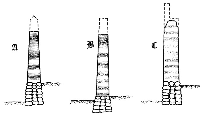
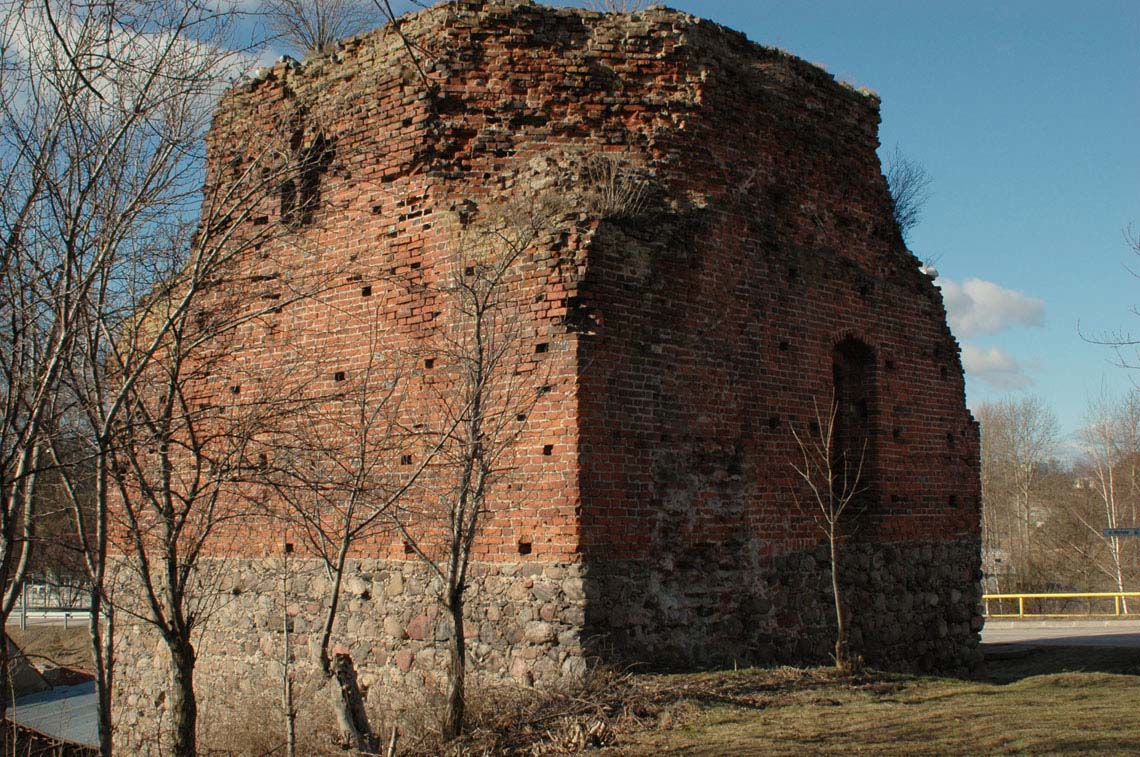
The defensive wall was built of brick in the Flemish bond, on a high plinth of granite stones, reaching from the outside to a height of 5 meters. The thickness of the walls, depending on the section, oscillated between 1.6 – 1.7 meters to 2 meters and reached up to 8 meters in height. It is possible that it was topped with battlements and a wall walk. The ring of walls included several four-sided (rectangular and on a plan similar to a square) half towers, spaced about every 20-25 meters. They were protruded in front of the neighboring curtains, probably one storey higher or equal to them and opened from the town side. Inside, the division into floors was provided by wooden ceilings. The lowest floors devoid of arrowslits had to act as warehouses, as long as they were closed with wooden or half-timbered walls. In critical points for the defense of the town, such as the corners of fortifications, there were full, closed towers. For example, in the south-west corner there was a tower called the Mill Tower, built on a square plan, turning into an octagon above.
Entry to the town was posible from three sides: by the main gate called High on the north side, the Mill Gate, also called Złotowska, which was located near the south-west corner, and the Fisherman’s Gate located near the south-eastern corner, the latter being a rather small wicket mainly used by fishermen. Perhaps there was also a postern located in the middle of the eastern part of the perimeter, leading to the suburban fields. The High Gate was located at the end of a long street with a north-south axis, connecting with the market located in the southern part of the town. The Mill and Fisherman’s gates were located at the end of shorter streets, also connected to the corners of the market square.
Current statey
To this day, four fragments of defensive walls have survived along with three half towers, scattered in the western part of the former perimeter (Barlickiego Street), and in the south-western corner of the town there is the lower part of the Mill Tower, also known as the Witches’ Tower. According to an urban legend, it was here that the trials and executions of women accused of witchcraft took place. Recently, it has been superstructured with an ugly, modern finial that collides with the medieval monument.
bibliography:
Biała karta ewidencyjna zabytków architektury i budownictwa, obwarowania miejskie, G.Uniejewski, nr 508, Debrzno 2000.
Dzieje miasta i gminy Debrzno, red. M.Fryda, Pruszcz Gdański 2014.
Lukas E., Średniowieczne mury miejskie na Pomorzu Zachodnim, Poznań 1975.
Ptaszyńska D., Miejskie mury obronne w województwie koszalińskim, Koszalin 1974.