

History
The castle was built under the Masovian Prince Janusz I the Elder, in the period from around 1388 to the beginning of the 15th century. It was built on the site of an early medieval hillfort, which had been the seat of castellans since the 12th century, and the main seat of the Masovian princes since the 13th century. Czersk appeared in records in 1330, around 1350 the market settlement near the castle obtained town charter and in 1386 the town was transferred to Chełmno law. In the above-mentioned 1388, the prince exempted the village inhabitants from construction work on the Czersk timber hillfort, which would indicate that in this favorable period for Czersk, plans were already made to transform it into a brick castle. As the creation of a more ambitious defensive structure required qualified labor and funds, renovation and construction duties at the hillfort were changed in a privilege to a monetary equivalent.
At the turn of the 14th and 15th centuries, the Vistula riverbed moved away from the town and the castle. Moreover, Masovian princes began to spend more time at the castle in Warsaw, which caused the importance of Czersk to decline. Already in 1398, the prince ordered the chapter at the collegiate church of St. Peter to move to the church of St. John in Warsaw, which was finally carried out in 1406. Although the castle was not abandoned, no major investments were carried out there more than a hundred years after its completion. The change was brought only in 1525 by the incorporation of Masovia into the Polish Crown. Czersk then became one of the centers of Queen Bona’s estate, which contributed to a short-lived period of prosperity. The castle was expanded, on the queen’s initiative the slopes of the castle hill were planted with vineyards, gardens were established, and more livestock was brought.
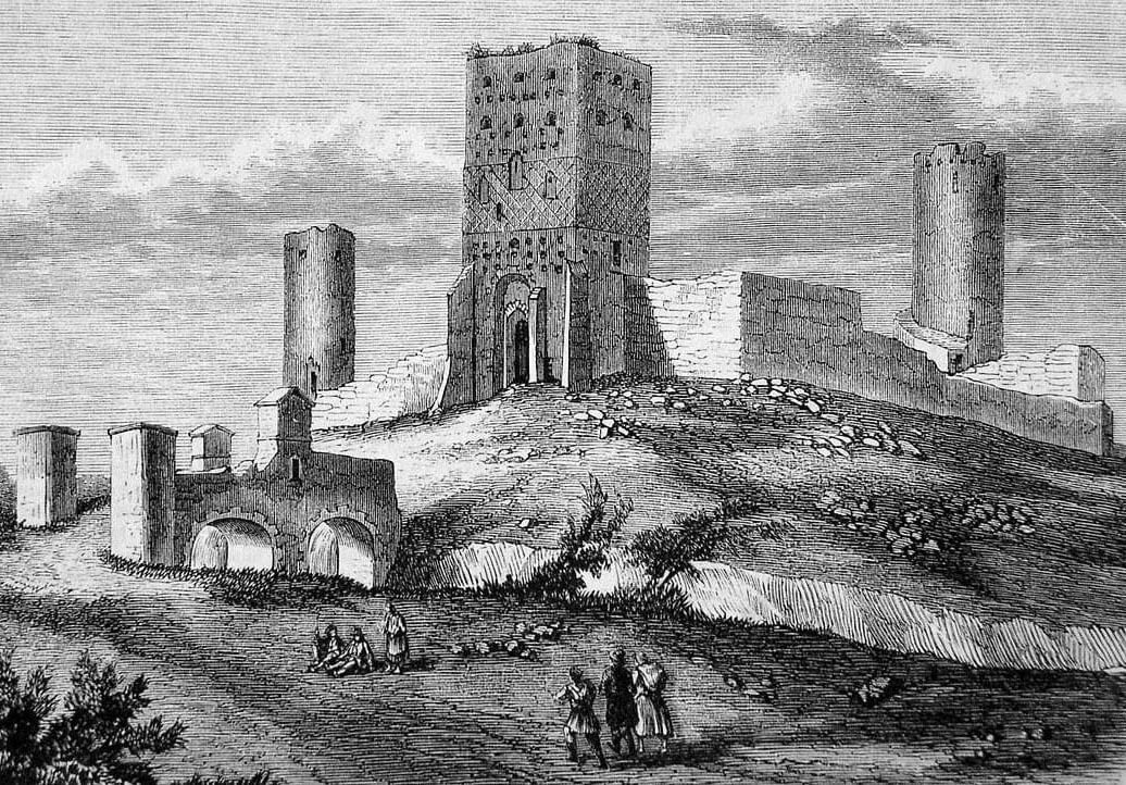
At the end of the 16th century and at the beginning of the 17th century, the castle was used by starosts. During the Deluge, it was occupied by Swedish troops, who blew up the walls and buildings, when they were forced to withdraw in 1656, and also burned the town hall, hospital, churches and houses in nerby town. Despite the renewal of privileges by King Jan Sobieski, Czersk did not return to its former glory. The last renovations were carried out in the castle in 1762 by the staroste of Czersk, Franciszek Bieliński, in connection with the location of the town and land courts with archives in castle rooms. However, after the fall of the Kingdom of Poland, the castle was finally abandoned, and serious damages were caused by using it walls as a source of free building material.
Architecture
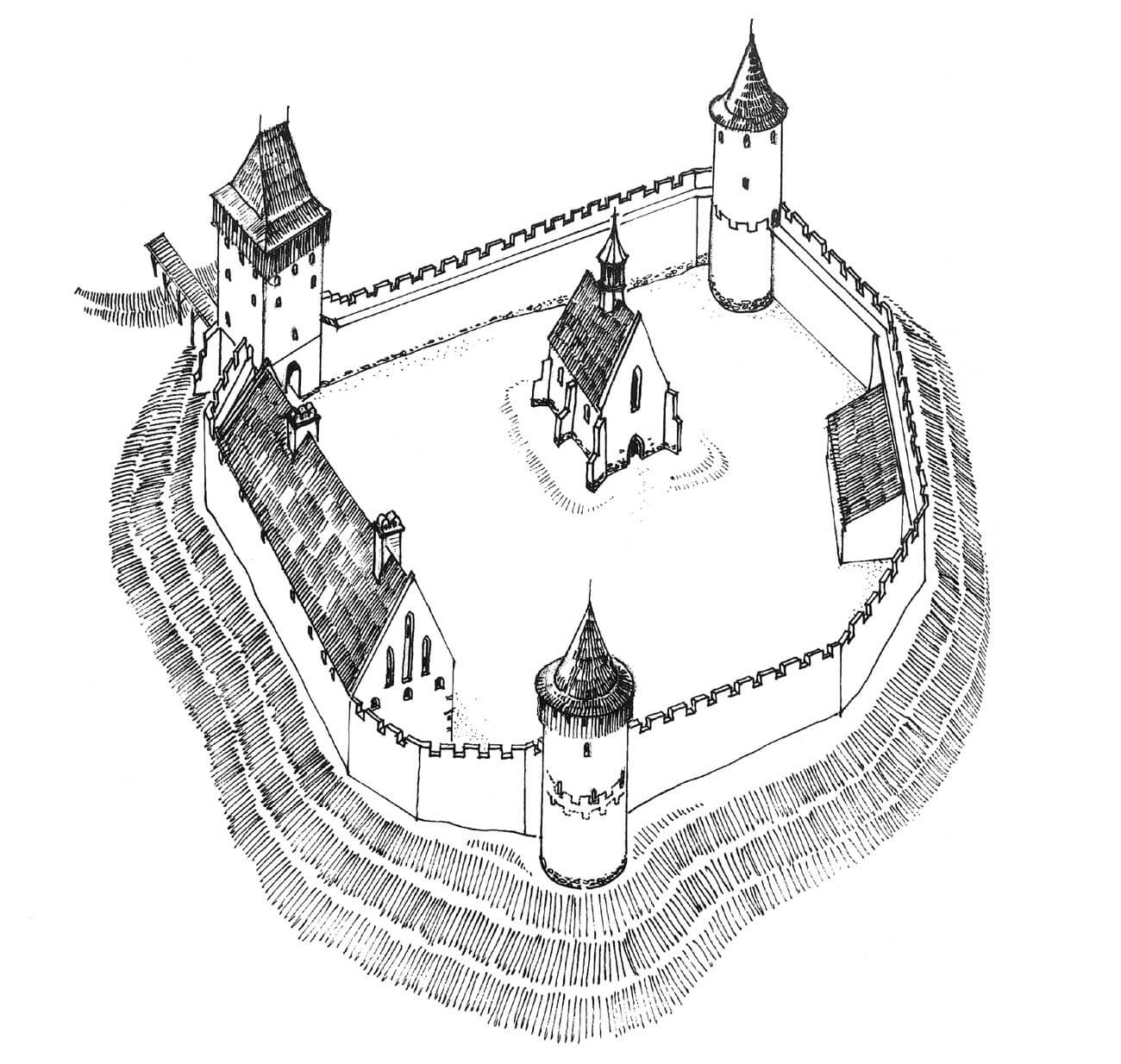
The castle was situated on the escarpment, in the bend of the Vistula River and its numerous branches and tributaries. Steep slopes protected the castle especially from the east, where the Vistula first flowed at the foot, and since the late Middle Ages there was a narrow lake formed from the flowing streams, after Vistula course was changed and the bed moved away. There were also high slopes on the southern and southwestern sides, where the small Czarna River flowed towards the Vistula, creating a marshy valley. From the north, the immediate foreground of the castle was occupied by two hills on the promontory, separated by a ravine, behind which the slopes descended into the valley of the Cedron stream. This ravine led to a path to the crossing over the Vistula. The gentlest approach was from the north-west, from where there was an access road from the town, passing the castle and reaching the gate from the north-east. The castle was expanded in four main stages, but its basic layout remained unchanged throughout the Middle Ages, located on a riverside promontory.
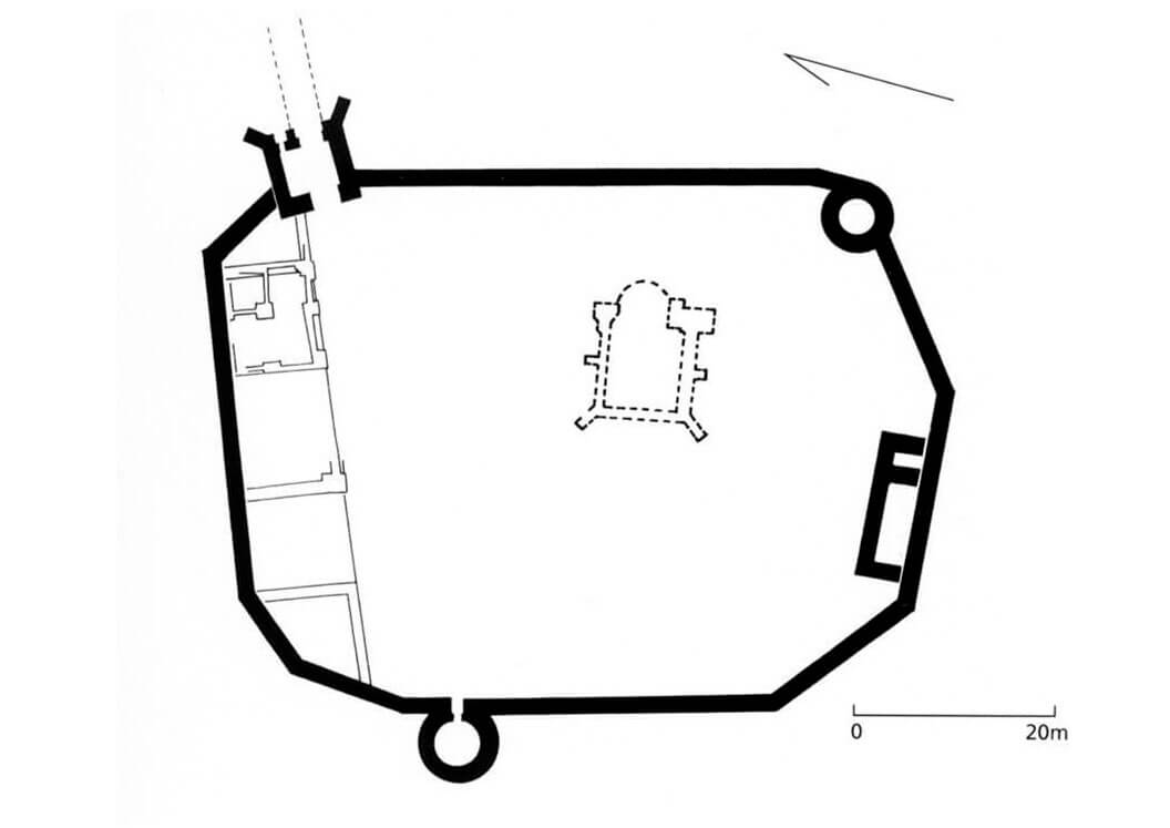
At the end of the 14th and the beginning of the 15th century, a perimeter of the defensive wall was created, encompassing an irregular, slightly oval-like courtyard. The wall consisted of straight sections, the two longest of which: eastern and western ones were 50 and 40 meters long respectively, and ran almost parallel to each other. The northern fragment, 38 meters long, was almost perpendicular to them, while in the south the perimeter was bent twice, creating three sections of similar lengths. The walls were on average 1.8 meters thick and about 8-9 meters high. It were built of bricks on a foundation and a plinth of erratic stones. It were probably topped with a wall-walk and a battlemented parapet.
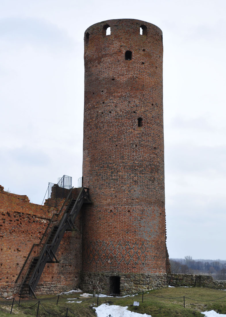
The perimeter of the defensive wall was reinforced with three towers, located from the west, south-east and north-east. The latter served as a gate and was the only one to have a four-sided form, while the others were built on a circular plan. Initially, the cylindrical towers had a height equal to the curtains of the defensive wall, only the most important gate tower was higher. All towers were raised in the years 1526-1547, thanks to which the castle gained three height dominants.
The residential and utility buildings of the castle were attached to the defensive wall and were probably originally mostly made of wood or half-timbered. The main brick building was located in the northern part, on the western side of the gate tower. It had an elongated shape with a facade length of about 17 meters and a width of 10 meters. The two-story interior was planned. In the 16th century, the building was enlarged and an additional house was built on the southern side of the courtyard.
In the central part of the spacious courtyard there was the collegiate church of St. Peter, relatively small but exquisitely decorated. It was an aisleless building with dimensions of 17.1 x 7.4 meters, buttressed, with a narrower, single-bay chancel with a three-sided closure. The interior was topped with a ribbed vault and covered with polychromes. Its floor consisted of square ceramic tiles, 4 cm thick, yellow-brown and green in color, and thinner tiles of various shapes that could be used to create circle patterns with inscribed stars. Some of the wall decorations could have been made of glass mosaic cubes.
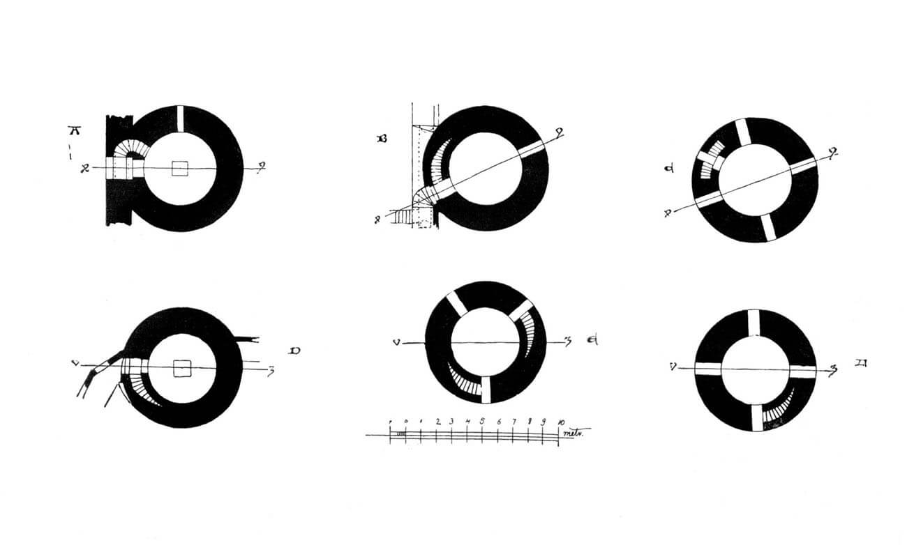
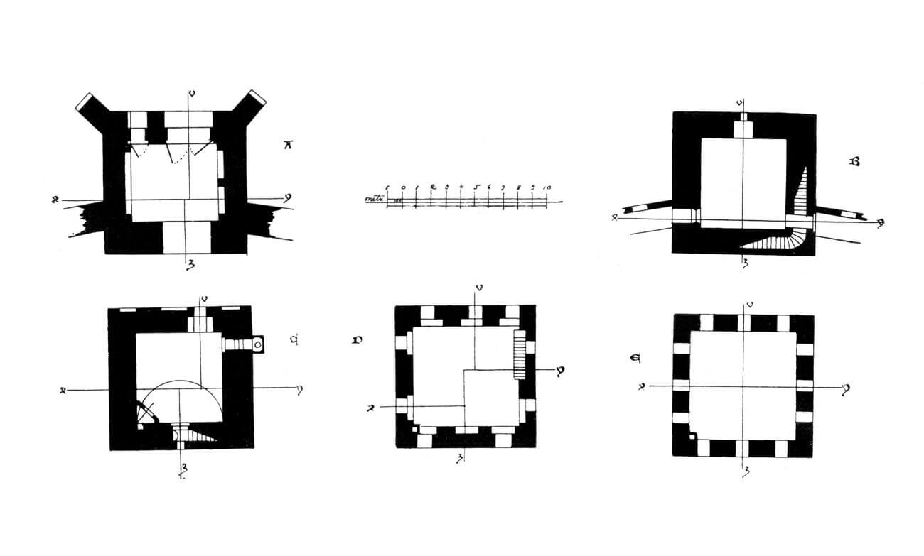
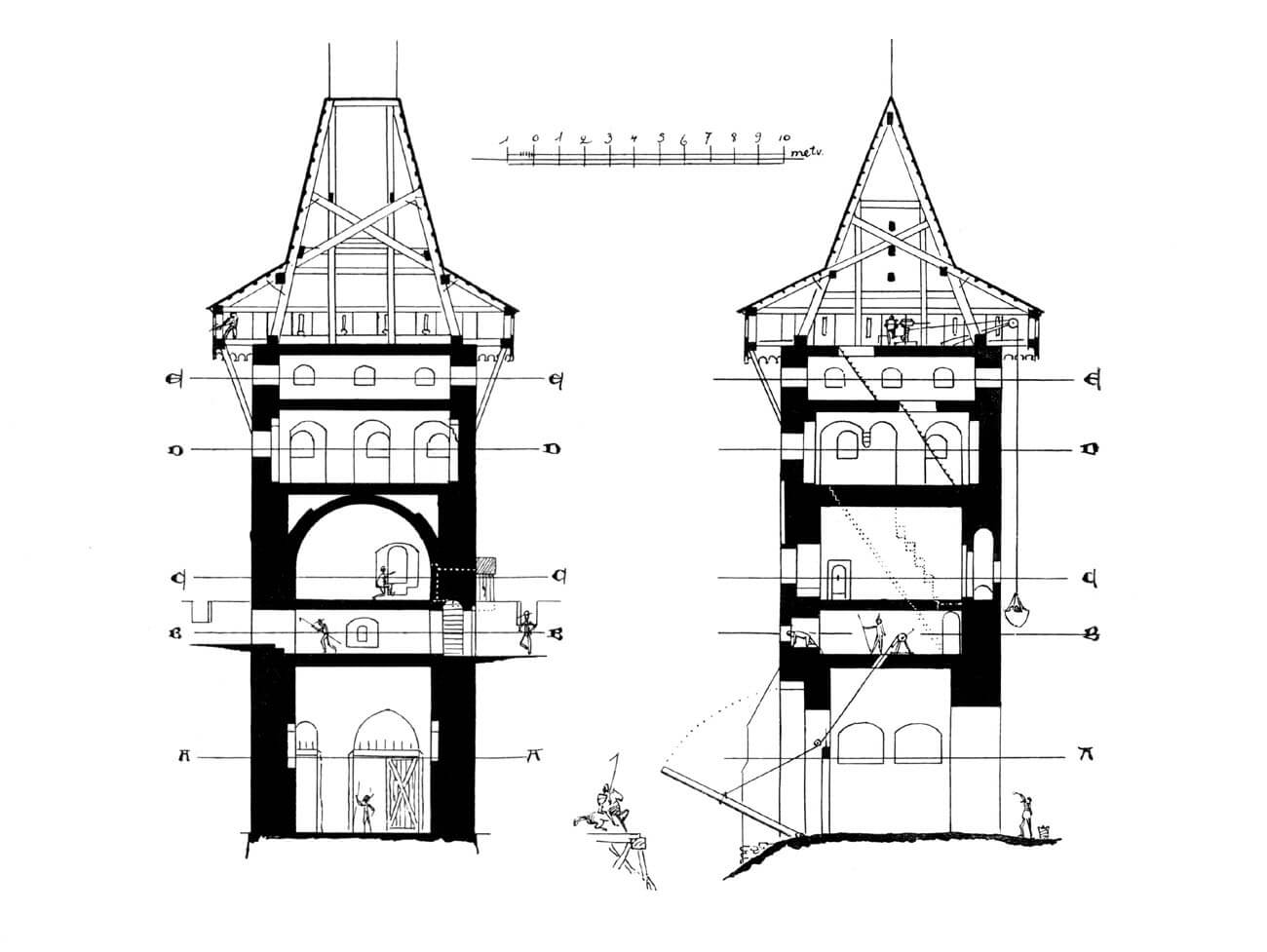
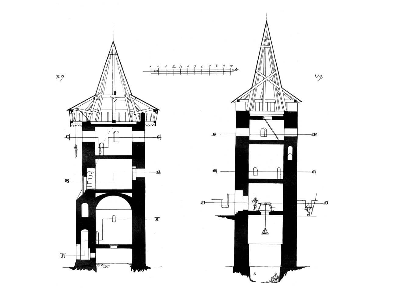
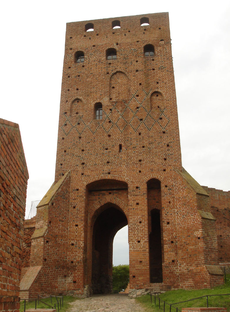
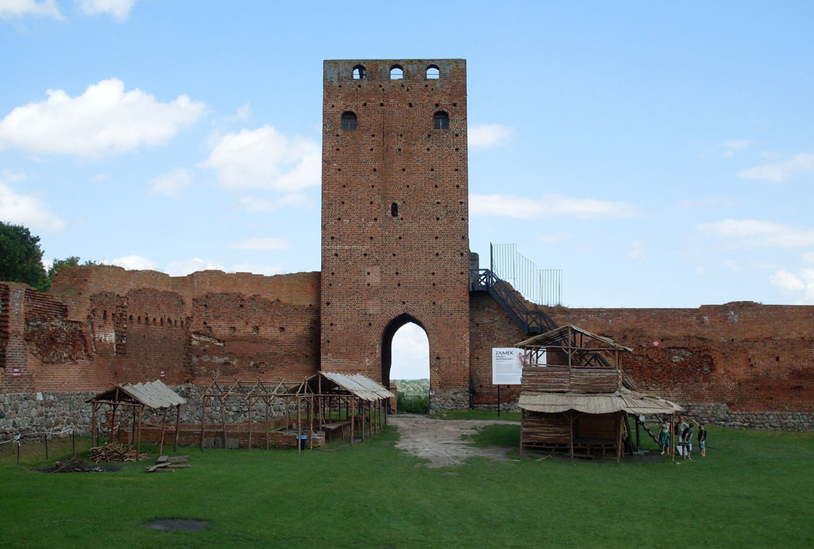
The gate tower eventually became 22 meters high and was strongly protruded outside the perimeter of the defensive wall. It was founded on a rectangular plan similar to a square with external dimensions of 8.8 x 8.6 and internal dimensions of 5.3 x 4.9 meters. On its ground floor there was a pointed gate opening and a smaller pedestrian gate, both placed in recesses intended for raised drawbridges. These bridges made possible to cross the artificially made moat. The gate passage did not have a portcullis. The external façades of the tower were decorated with rhombus patterns made of zendrówka bricks, and were regularly separated with masonry putlog holes, left by the scaffolding used during construction. The two corners of the tower facing the moat were supported by buttresses.
At the end of the Middle Ages, the gate tower had four floors above the ground floor, the first of which was accessible via wooden stairs located along the eastern defensive wall. This storey had a typically defensive function and was also the gatekeeper’s room. There were probably turnstiles for operating drawbridges there. The man using it could watch those approaching the castle through a narrow window above the gate. The room was low, about 2.7 meters high, covered with a wooden ceiling. In the southern wall there was a vestibule with two flights of stairs, both leading upwards. The vestibule also had an exit from the wall-walk.
The third floor of the gate tower was a high, barrel-vaulted room, which probably served as the apartment of the burgrave of the castle. This room was heated by a fireplace located in the north-west corner, it had a window in a recess with two benches in the eastern wall, from which it was possible to observe the entrance to the castle on the north-east side, as well as a small door to the wooden latrine in the southern wall, suspended over the moat in front of the defensive wall. On the outside, at the height of the burgrave’s chamber, there were three shallow, once plastered, ogival recesses, probably originally housing painted emblems of Masovian rulers.
The second flight of stairs from the first floor (from the vestibule in the thickness of the wall) led straight to the fourth floor, bypassing the burgrave’s chamber. These stairs, unlike the previous ones, had high steps, intended to speed up getting to the top or rather to facilitate defense, giving the defenders an advantage in height. The fourth floor of the tower was defensive in nature, as it had loopholes in all the walls. It was also accessible by a separate staircase from the burgrave’s chamber.
The fifth floor ended the tower brick wall. It was low and accessible only by a ladder. There were three loopholes in each of the walls, and above them there were hoardings, i.e. a wooden porch running around the attic of the tower, hung on the outer face of the walls. It allowed attackers to be hit through holes in the floor, straight from above. For its construction, the perimeter wall of the tower on the top floor was unusually thicker than on the lower floor, where it had to be reinforced with wall pillars. This would also indicate that at the time of the construction of the penultimate floor, the top floor with a hoarding room had not yet been planned.
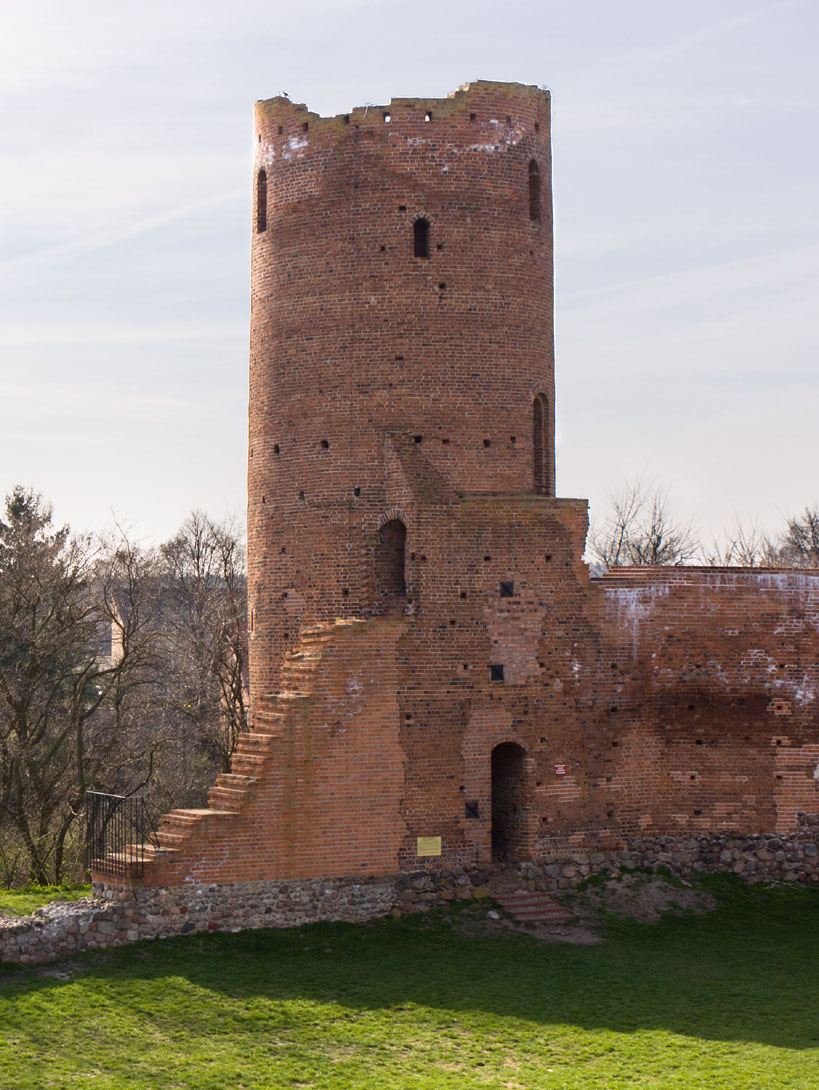
The south-eastern tower was located in the bend of the defensive wall and almost entirely inside the ward, which may have resulted from fear of slopes sliding. Its walls were 2 meters thick in the lower part, and 1.7 meters thick on the upper levels, but originally the height did not exceed the level of the wall-walk in the neighboring curtains, so it was about 8 meters high, and only after increasing in the 16th century it finally reached over 24 meters height. Before the that, the tower ended with a battlement, after the raise it ended with a conical roof. Its interior was accessible only from the defensive wall. The lowest floor was occupied by a prison dungeon, located about 10 meters below a trapdoor in the first floor. Food and prisoners were probably lowered using ropes. Communication with the upper floors was provided by stairs placed in the thickness of the wall. The lack of heating devices would indicate that they were not used for living. Given its poor defensive properties, the main purpose of the tower could have been to provide a wide view of the Vistula valley.
The north-west tower, 9 meters in diameter, was almost entirely located outside the perimeter. Originally, it was low, about 9 meters high, it had the highest floor at the level of the wall-walk and it was topped with battlement. In the 14th or 15th century, it was raised by a few meters and again topped with a battlement, probably to level the defensive wall of the northern section, which was built in the last stage of construction process. In the 16th century, the north-west tower became equal in height to the other towers. Its role was to flank the adjacent parts of the wall from the town side. Stairs from the courtyard level led to the interior. Below this main floor, lit by one narrow window and covered with a vault, there was a small cell, accessible through a trapdoor in the floor. Above there were two more floors and a hoarding porch. The second floor was probably connected to a nearby residential building through a portal and a wooden bridge.
Current state
The castle has survived to this day in a state of ruin. The best preserved elements are: a four-sided gate tower, two cylindrical towers and a large part of the perimeter walls. The highest height of the latter (with a partially reconstructed crown) is visible on the eastern and northern sections, while the long fragment between the cylindrical towers is preserved only at the level of the stone plinth. The remains of the courtyard buildings are even less visible. The monument is open to visitors during the hours described on the official website of the castle here.


bibliography:
Kunkel R.M., Architektura gotycka na Mazowszu, Warszawa 2005.
Leksykon zamków w Polsce, red. L.Kajzer, Warszawa 2003.
Szyszko-Bohusz A., Trzy nasze zamki – Czersk, Checiny, Ogrodzieniec, Kraków 1909.
Zagrodzki T., Czersk, zamek i miasto historyczne, Warszawa 1996.