
History
Braniewo (Braunsberg) was founded in 1254 on the relics of the destroyed Prussian stronghold Brusebergue, but after the destructions made by the Prussians in 1242, 1261 and 1277, the location had to be repeated in a new, more defensive place. In the 80s of the 13th century, the natural bend of Pasłęka river was chosen for this purpose, which protected the settlement. The construction of the earth ramparts was initiated in the years 1279-1284, and the earliest mention of the timber palisades surrounding the town comes from 1300. The first timber and earth fortifications were then gradually replaced by brick walls. These works lasted until around mid-fourteenth century, however, at the beginning of the fifteenth century, walls were considered insufficient and by 1434 the second, outer belt of fortifications was erected. Thanks to the contracts concluded by the Old Town Council, wall builders from the 15th century are known. In 1434, the contract was signed with masters Michael and Henry, in 1444 with master Henry and his associate Kirst, and in 1505 with master Hans. Further contracts regarding the most likely repair of the walls in connection with the last Polish-Teutonic war, were concluded with master Hans in 1520 and 1522, and in 1562 with the master Albrecht Kobijewski from Pasłęk.
During the Middle Ages, the Braniewo fortifications performed their role well, most often discouraging and deterring invaders from assault. In 1311, Lithuanian leader Witenes plundered Warmia, but did not dare to attack Braniewo. He reached the town, but only called insults to the Warmian bishop Eberhard of Nysa standing on the wall and burned down the suburbs. Also in 1414 during the Polish-Teutonic Hunger War, the Polish army under the command of Władysław II Jagiełło, avoided the town without taking an attack. In 1455, the unsuccessful siege of the old town was carried out by the Teutonic Knights, and in 1461, the burghers defended themselves against the night attack of Polish mercenary forces led by Jan Skalski, who was then wounded. Another siege took place a year later, but Polish troops led by Piotr Dunin departed after a few days. An ineffective siege was also carried out during the Pope’s War in 1478. Due to the lack of hope of capturing the town and the prevailing hunger, the Polish army withdrew. The longest siege Braniewo survived in 1520, during the last Polish-Teutonic war. It was then besieged for three months by Polish troops. In this case, the town avoided assault and large losses due to lack of artillery among the besiegers. The surprise attack, which took place in the New Year of 1520, when the town was taken by the Teutonic Knights, led by the Grand Master Albrecht Hohenzollern, turned out to be effective. The townspeople were then in the church of Saint Catherine, and the only defender who saw the danger and tried to lift the drawbridge at the Mill Gate, was killed. Decades later, when the artillery had already been improved and popularized, the townspeople preferred to surrender Braniewo and pay contributions, rather than risking plundering and destruction. This was done in 1577 during the attack of the Danish-Gdańsk forces and in 1626, when after a short resistance and skirmishes in the suburbs, Braniewo capitulated to the Swedish king Gustav Adolf.
During the Swedish occupation of 1626-1635, the conquerors in the foregrounds of the town, under the supervision of Marshal Wrangel, built early modern bastion fortifications. These fortifications were rebuilt in 1655-1663, during the next occupation of Braniewo, this time by the Brandenburgians. It was connected with the decrease of the importance of the original fortifications. From the 17th century, the medieval town walls ceased to serve a defensive function and began to be enclosed with huts and stalls. At the beginning of the 19th century, all gates and their additional fortifications were removed, and until 1843, individual sections of the walls and some towers were demolished.

Architecture
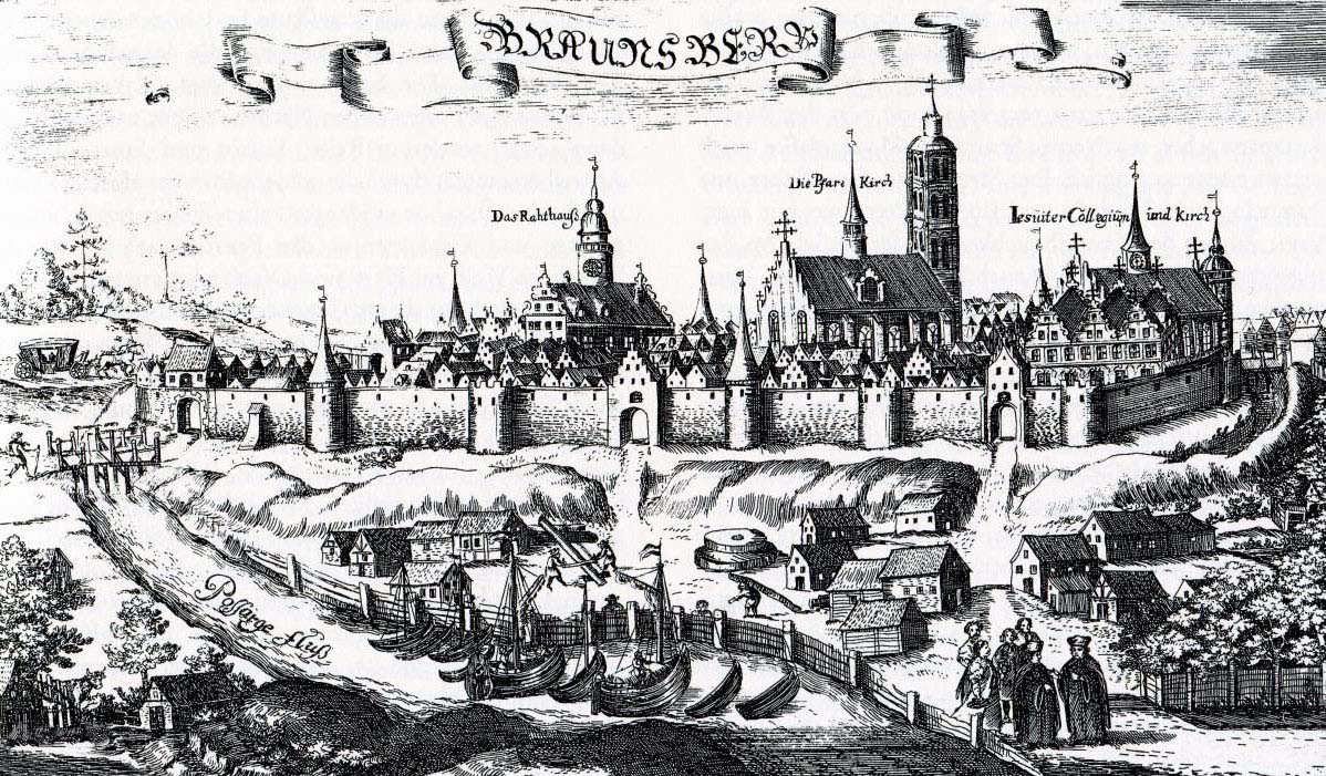
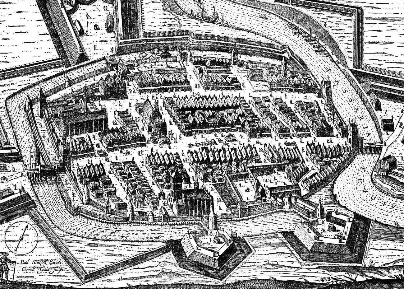
The fortifications of Braniewo were on a plan similar to an elongated oval with dimensions of about 400 x 250 meters and were placed in the bend of the Pasłęka river, protecting the town from three sides. In order to increase the defense, in the 13th century a canal was drained from the Pasłęka river, which became the moat. At that time, the river itself changed its natural course, which made the old bend a moat, and the ditch in the east – a new river bed. The water level in the moat was regulated by damming devices, placed, among others, at the Blue Tower.
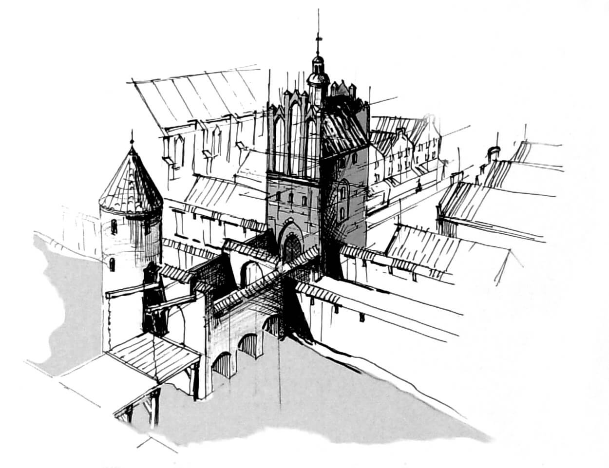
In the south-eastern part of Braniewo there was a rectangular Teutonic Knights castle (later bishop’s castle) with dimensions of about 55 x 80 meters, located mostly inside the town, in the ring of the main perimeter of the fortifications only on the line of the southern foregate of the main castle house. Thanks to this gate, castle kept its autonomy, allowing residents to freely enter and leave the castle without the need to use the town gates. The north-west corner of the Braniewo was occupied by a Franciscan friary from around 1330, and in the southern part of the town there was also a magnificent parish church of St. Catherine. Most likely, Braniewo did not have an underwall street around its perimeter, it functioned only in the southern and south-western parts.
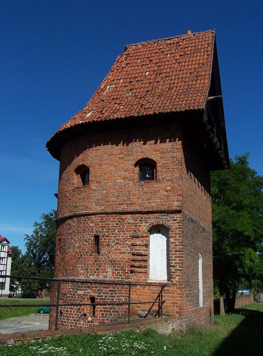
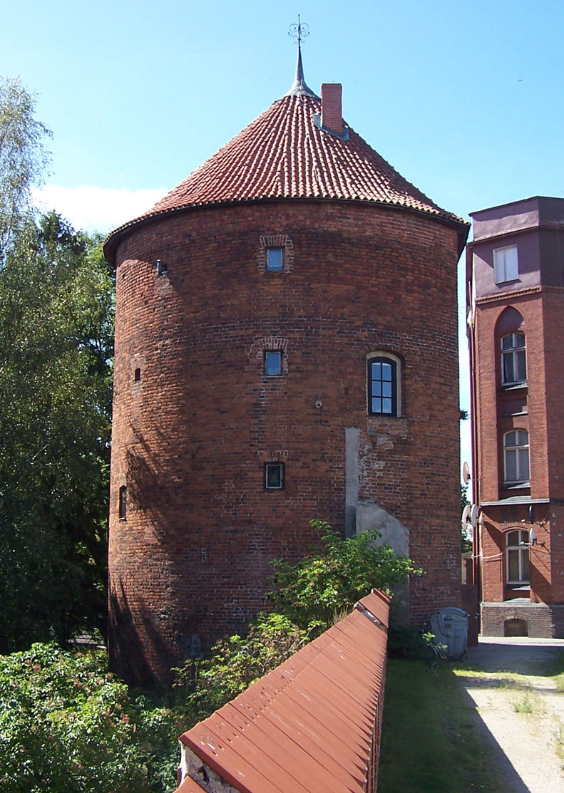
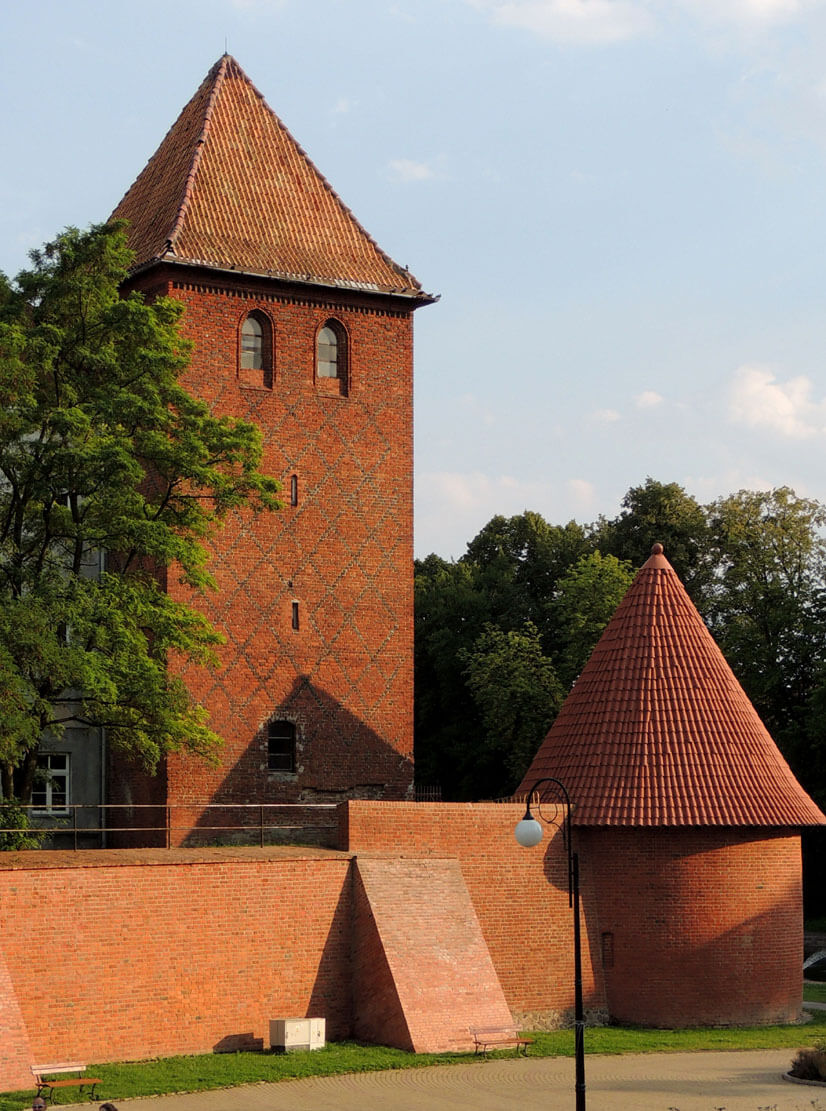
The town defensive wall was 1.5 meters thick in the ground floor, but it narrowed upwards. Presumably, it was crowned with a covered porch with arrowslits pierced in a simple breastwork, it is not known, however, whether it was the original crowning of the wall or the effect of late medieval transformations in order to adapt the fortifications to the use of firearms. The wall was reinforced with at least six towers: the four-sided Klesza in the north-west corner (raised around 1500), the four-sided Taurus Tower near the north-east corner, or the cylindrical Executioner’s Tower in the south-west corner. On the south side, at the turn of the 14th and 15th centuries, a horseshoe-shaped, four-storey Treadmill Tower (also known as the Monastery or Nuns’ Tower) and the Blue Tower was placed, protruding significantly in front of the perimeter with which was connected by a single curtain. It stood in the moat in front of the Church Postern which it flanked, and at the same time protected the damming devices regulating the water level. The Taurus Tower was erected on a square plan with sides of 6.7 meters, a wall thickness of 1.1 meters and a height of 14 meters. Its interior was to house a vaulted prison cell for the lower social classes. For a change, the higher-born were kept in a cell located in the north-eastern Burgher’s Tower. In addition, between the Executioner’s Tower and the Treadmill Tower, there was a small, nameless tower on a quadrilateral plan with dimensions of 7.3 x 4.6 meters and walls 1.2 meters thick. Originally, it was open from the town side, later closed with a half-timbered wall. The Thieves’ Tower, appearing in written sources, has not yet been identified.
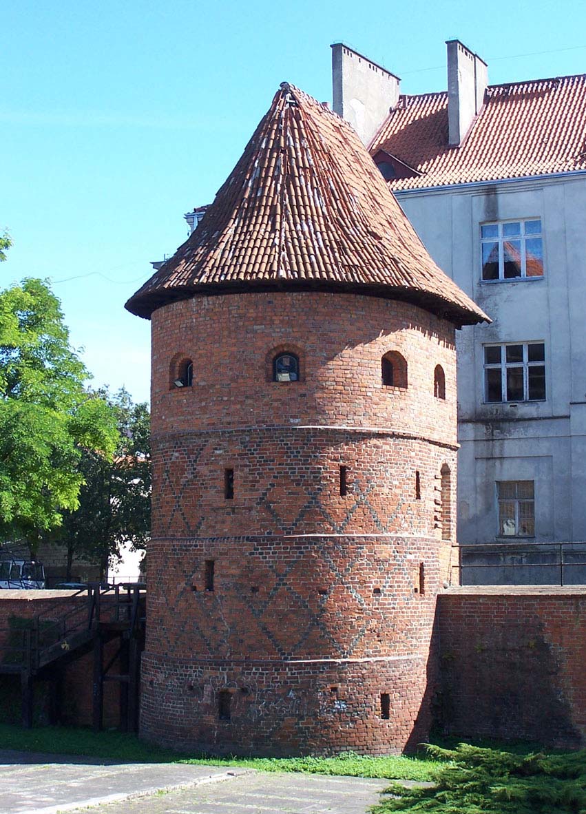
In the first half of the fifteenth century, the fortifications were supplemented with a second, lower line of the defensive wall, led about 15 meters from the main wall, but only from the north, west and partly south sides. In the south, the outer wall of the zwinger was connected with the Treadmill Tower from where it ran towards the south-west corner, and in the north it was connected again with the curtain of the main wall in the corner of the town. The outer ring was reinforced with about six towers, most of which were nameless. The cylindrical tower was erected in the north-west corner, right in front of the Klesza Tower, next to it, on the northern side of the perimeter, a horseshoe-shaped Powder Tower was built, three more on the north side were rounded, and one on the south-west was quadrilateral. The outer wall was reinforced with foregates at the gates located from the west, north and east.
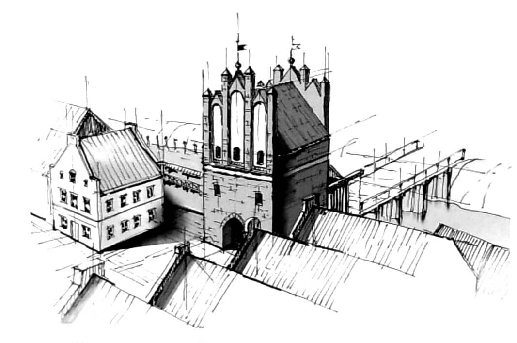
There were five gates and two posterns leading to the town, three of which were the main ones on the extension of the most important streets leading from the corners of the centrally located market square. You entered the High (Upper) Gate from the west, the Monk Gate and the Fisherman Gate (later called the Nail’s Gate or the Water Gate) from the north, and the Butcher’s Gate (also known as the Brazier’s Gate) and the Mill Gate from the east. Apart from them, there were two more wicket gates on the southern side: Castle and Church gates. The main gates were located in four-sided towers with passages in the ground floor. The exception was the Fisherman’s Gate, which probably consisted of an oblong gatehouse flanked by two oval towers.
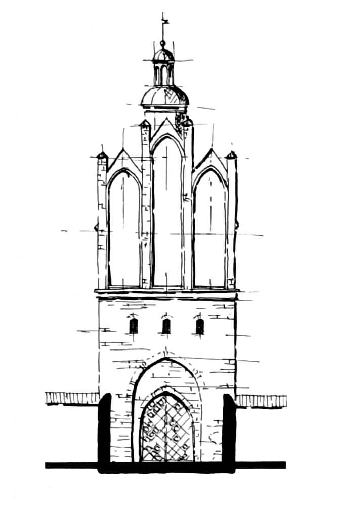
The most representative was the High Gate, situated in the highest point of the town. It was erected on a quadrilateral plan with dimensions of 9.3 x 9.6 meters with a maximum wall thickness of 1.9 meters. It was about 18 meters high and only a small part of it protruded in front of the adjacent wall curtains. The gateway located in the ground floor was 3.9 meters wide and 5.1 meters high. Above the pointed portal and three small windows, its front façade was decorated with high blendes ended with three small gables and pinnacles. At the time of the construction of the zwinger wall, the foregate’s neck was extended, and at the end of the Middle Ages it was preceded by another fragment of the foregate built on the moat. It was equipped with a drawbridge and flanked from the north by a cylindrical Charcoal Tower.
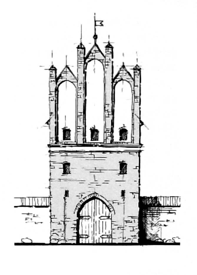
The eastern Mill Gate was located at the end of Długa Street, near the town mill, opposite the bridge leading to the New Town of Braniewo. It was erected on a square plan with sides 9 meters long, walls 1.4 to 1.9 meters thick and 18.3 meters high. In the ground floor there was a gateway 3.4 meters wide, and above two floors covered with a gable roof and equipped from the east and west with high Gothic gables, which had a form similar to that used in the High Gate.
Current state
The turbulent history of Braniewo, and especially the demolition works from the 19th century, have survived to this day the Treadmill Tower from the main line of fortifications, located near the basilica of St. Catherine, and the Klesza Tower with a partially preserved outer corner tower in the north-west corner of the town. You can also see the preserved semi-cylindrical Powder Tower from the outer belt of the town walls on the northern side of the former perimeter. The surviving fragments of the defensive wall, although relatively numerous, are today significantly reduced compared to the original state and significantly rebuilt.
bibliography:
Czubiel L., Domagała T., Zabytkowe ośrodki miejskie Warmii i Mazur, Olsztyn 1969.
Jaroszek W., Dawne braniewskie obwarowania miejskie, Braniewo 2019.
Rzempołuch A., Przewodnik po zabytkach sztuki dawnych Prus Wschodnich, Olsztyn 1992.
Sypek A., Sypek.R., Zamki i obiekty warowne Warmii i Mazur, Warszawa 2008.
Webpage historiabraniewa.hekko.pl, Dawne braniewskie fortyfikacje miejskie.