

History
The residence of the bishops above the shore of the old Pasłęka riverbed was not the first castle in Braniewo. The former castle or watchtower, founded The Teutonic Knights in the place of the settlement of the Warms tribe around 1240 years. It was to be the basis for further expansion, stopped as a result of the first Prussian uprising in 1242. After peace in 1249, the locals pledged to build a church in the settlement of Brusebergue, and colonization could continue. In 1250, colonists from Lübeck established Braniewo on the river island, which the first bishop of Warmia, Anselm, chose as his seat. This settlement received town privilege in 1254, but was completely destroyed along with the Teutonic castle during the second Prussian uprising. In 1261, the leader of the Warms tribe named Glappo attacked it, and the defenders left Braniewo and went to Elbląg after a short fight. When the uprising was suppressed, the colonists returned trying to rebuild the settlement, but the Old Prussians destroyed it again in 1277. This event influenced the decision to move the castle and the settlement to a new, more defensive place in the upper part of Pasłęka in 1279.
The brick castle was started to be built in the second half of the 13th century during the reign of Bishop Henry Fleming, most likely after 1280, when the the privilege was granted to the settlement. The first reference to construction works was recorded in 1282 (Castro Brunsberg), and the end of the first stage was probably completed at the end of the 13th century. After the creation of the Warmia diocese in 1243, Braniewo was handed over to the bishops and chapter, and the first bishop, Anselm, chose it as his seat and established a cathedral there. The most important secular function in the castle was performed by the bishop’s vogt (burgvogt), also known as the land vagt, who was the supreme judge of criminal cases and military commander. He also took care of public order and safety and led the settlement action. After the destruction during the second Prussian uprising, the chapter moved to Frombork, where the capital of the diocese was transferred, and from 1340 Braniewo remained only the seat of a burgrave, responsible for the castle and crew and having certain judicial privileges and with the election of the town council. The land in its immediate vicinity belonged to the castle, income was also provided by the mill in Pasłęka, the town bath, taverns and tributes from townspeople and dependent villages.
At the end of the 14th and 15th centuries, the castle was attacked many times by the townspeople against the episcopal authority. In 1394, the conflict was caused by the merger of the New and Old Town in Braniewo, which was unfavorable to the latter. When bishop Henry Sorbom came to Braniewo in 1396 to hold talks with the town council, the townspeople attacked and captured the castle, although the bishop managed to escape through a side gate. The townspeople had to leave the damaged castle after the relief of the Teutonic Knights, and then, on the order of the Grand Master Konrad von Jungingen, had to renovated it at their own expense within five years. Ultimately, however, they succeeded, as the towns of Braniewo were separated again in 1398.
The wall and towers of the castle from the town side were also damaged in 1454, during the storming of the townspeople and the troops of the Prussian Union, but the remaining part of the castle was only plundered, and it was decided to use it for further military operations of the Polish-Teutonic war. As early as 1455, Teutonic troops under the command of Henry Plauen made an unsuccessful attempt to recapture Braniewo. The town council then rejected the negotiations, and the Teutonic Knights only managed to burn the New Town. In the same year, it was decided to hand over the defense of the castle to the mercenary knights of the Polish king under the leadership of Jan Skalski. Soon, however, they turned out to be so troublesome that in 1461, in the absence of Skalski, the townspeople attacked the Czech garrison, captured the castle and captured about 100 mercenaries. Then they handed over the castle and the town to Bishop Paweł Legendorf. Unable to accept the loss of the town, Jan Skalski tried to recapture Braniewo at the end of 1461, and in 1462 the town was besieged by Polish troops. Ultimately, it was only the Second Peace of Toruń of 1466 that granted Braniewo and Warmia to Poland.
Once again, the castle was conquered in 1478 by the troops of the Warmian bishop, Nocholas Tungen, not accepted by King Kazimierz Jagiellończyk. It started a two-year war devastating the surrounding areas. The castle and the town were besieged by the Polish army for a month, but to no avail. Warfare also affected the castle in the first half of the 16th century, during the last Polish-Teutonic war. The castle and the town were seized in 1520 by the army of Albrecht Hohenzollern and returned only after five years as a result of the Prussian tribute. During the occupation, artillery was to be strengthened in the castle, which, directed towards the town, kept it in obedience.
In the 14th and 15th centuries, the castle underwent a medieval expansion. The first known early modern renovation works were carried out on a larger scale only in 1602. At that time, the towers from the town side did not exist anymore, so the castle was not an independent defensive structure, and the medieval fortifications were obsolete. That is why the Swedes, who occupied Braniewo from 1626, built ramparts and bastions in the foreground of the town. The castle survived in this form until the mid-nineteenth century, when it was transformed into a school, and then in the years 1873-1874 most of the buildings were demolished. Subsequent demolitions were undertaken between 1928-1930, and the final destruction of the remains of the castle and the town was brought about by World War II.
Architecture
The castle was erected in the south-eastern corner of the Braniewo Old Town, on the highest place of the left bank of the river, and at the same time in the Pasłęka bend. So it was surrounded on three sides by the town’s lands, and on the south it adjoined the town walls and the moat. From the west side, the castle was adjacent to the basilica of St. Catherine, and on the eastern side, near the castle and the town, the Pasłęka River flowed further into the Vistula Lagoon.
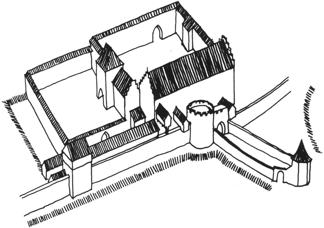
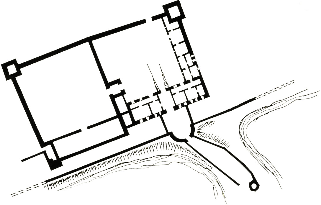
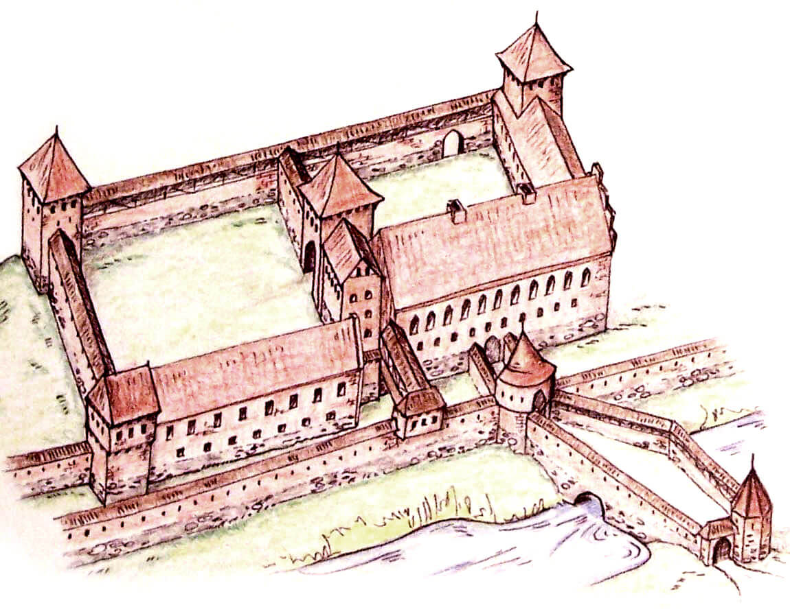
The castle was planned as a two-part complex, consisting of the main courtyard measuring 41 x 42 meters and the outer ward next to it. Both of these parts were quadrilateral in plan, with the southern side facing the river bank and the northern curtains facing the town center. The oldest buildings were built in the southern part, where the building of the outer ward and the upper ward were also the curtains of the castle’s defensive circuit. On the other sides, the courtyards were closed with simple curtains 2.1 to 2.5 meters thick. Presumably they were topped with a covered wall-walk. Another two curtains with a gatehouse in the center separated the courtyard of the outer bailey from the courtyard of the upper ward. Only after the construction of the town defensive wall, the southern buildings received additional protection from the river.
Initially, it was believed that in the second half of the 13th century, the main residential building with an axially placed gate passage was built, leading to a rectangular courtyard, while the second gate from the south-west led to the outer bailey. However, there is a possibility that the main residential house was originally located in the western part of the castle, turned out to be too small after some time and it was decided to build a new one, located more to the east. The originally planned outer ward on the eastern side would then become the main ward. This could explain the unique layout of the castle, in which the entrance led directly through the main house and the courtyard of the upper ward, then only to the outer bailey, and not the other way around. Changes in the castle layout could have taken place as a result of the destruction caused by the townspeople and the reconstruction carried out around 1396. On this occasion, the greatest disadvantage of the castle was also corrected, i.e. the lack of an access independent of the town, which could be dangerous in the period of a worsening of relations between the bishop and his subjects.
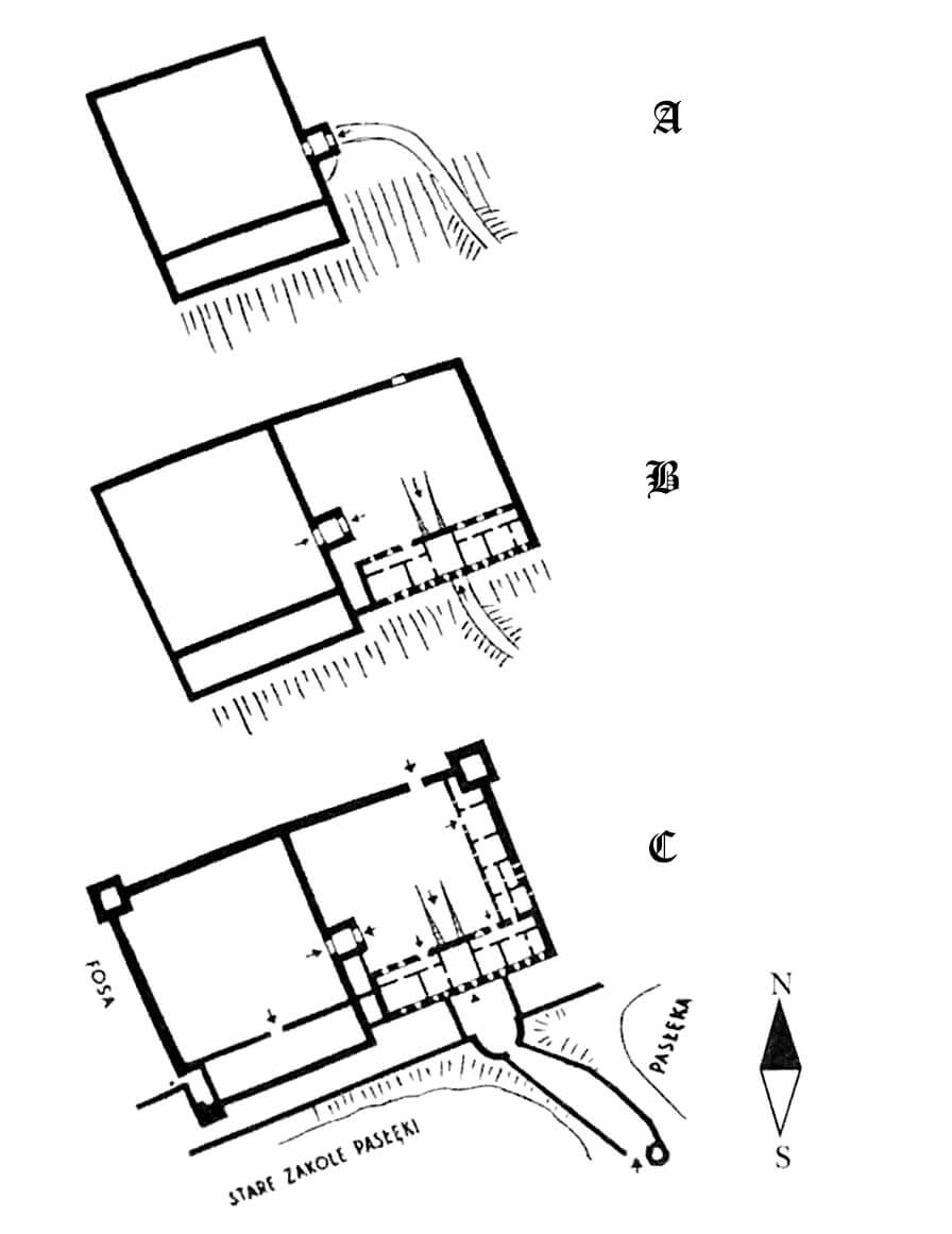
Finally, at the end of the fourteenth century, a rectangular castle with dimensions of 55 x 80 meters was developed with two courtyards connected by a four-sided gate tower with dimensions of 7 x 7.4 meters, located entirely in the eastern part of the castle. The entire complex was surrounded by a wall with two four-sided towers from the north-west and north-east, guarding the castle from the town side, and a third tower in the south-west corner. A gate was placed in the north-east curtain, and the second passage was in the south-west wall. The castle was connected with the town walls, maintaining its autonomy, however, thanks to its own fortified circuit and the gate from the river side. The north-east tower had dimensions of 8.2 x 8 meters, and the thickness of the massive walls varied from 2.2 to 3 meters (the north and west walls were the thickest). The inside of the tower was probably vaulted and perhaps had residential functions. The main building, measuring 10 x 36.3 meters, housed the most important bishop’s rooms. It had a basement with two overground storeys reaching a height of about 17.1 meters to the ridge level of the gable roof. In the western corner, it was connected by a overhanged porch with a dansker turret (latrine), suspended on the town defensive wall on the river bank. From the side of the courtyard, next to the building there was an avant-corps (7×6 meters) with a gate passage decorated with blendes. The entrance to it was like a ramp leading through the basement of the main house, on the other side it opened with a pointed portal around the gate’s neck, led through the width of the zwinger. In the fifteenth century, the southern gate was additionally expanded from the field side to the form of a barbican or an elongated foregate with a polygonal tower flanking the entrance. The foregate was placed on an earthen dike across the moat. The utility rooms of the castle were located in the eastern wing of the upper ward and in the southern wing of the outer bailey. The eastern range was 32 x 8 meters, it was two-story, partially with a basement (its basement was accessible only from the basement of the main house). It was lower than the main building of the castle, reaching about 11.5 meters at the ridge level.
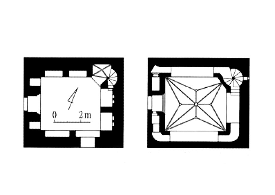
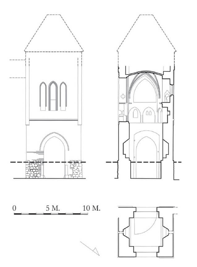
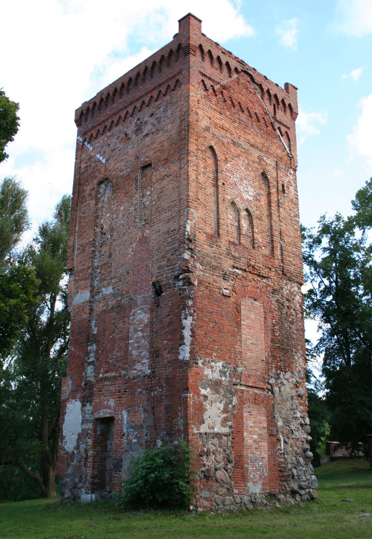
During the fourteenth-century expansion, the gate tower between the courtyards was raised from 8 to about 15 meters high, placing a chapel in its upper part and adding an annex from the south, serving as a link with the mian castle house. In the northern and southern walls there were arrowslits enabling firing at the space on the eastern side of the curtain wall. The passage, accessible through pointed portals, was 2.9 meters wide. The decorative tooth frieze placed above it was made in the eastern facade of the building. Also the newer one, the upper part of the tower had more decorative facades from the east, and the entrance from the external wooden porch to the spiral staircase connecting its upper floors was placed in the originally safer western facade. These features also suggest that the main part of the castle mentioned above could initially be located on the west side, and the outer bailey to the east. Originally, the tower was covered with a hip roof over a battlement. Inside, the chapel occupying the first floor of the tower was covered at a height of 7.5 meters with a stellar vault supported by artificial stone consoles. In the western corner there were brick, spiral stairs that led to the gallery running around the interior, formed in the thickness of the tower walls and open to the center of the tower with wide, pointedly closed arcades. The gallery was located 2.7 meters above the floor and was only 0.8 meters wide. It rested on pointed arches, narrower than at the top, on the corner parts of the room and on pillars in the middle of each of the three sides. In the west wall there was a high niche, while in the south there as a passage to the aforementioned small wing connected with the main castle house. It was originally the only entrance to the chapel.
Current state
Today, the only preserved elements of the castle are: the gatehouse, which stood between the main castle and the outer bailey, and fragments of the zwinger walls and the southern foregate. On the tower you can still see the remains of window openings and the old gate passage, all walled up until recently. In the years 2018-2020, a thorough renovation of the tower was carried out, during which, among other things, the windows and entrance opening were restored, the neo-Gothic top has been preserved, and the facades and interior were renovated. After the works were completed, the tower was made available to tourists, thanks to which you can see the magnificent Gothic chapel of St. Andrew. Unfortunately, it was decided to combine metal stairs and glass or plastic screens with the historic brick interior.
bibliography:
Garniec M., Garniec-Jackiewicz M., Zamki państwa krzyżackiego w dawnych Prusach, Olsztyn 2006.
Jaroszek W., Historia zamku biskupiego w Braniewie, Braniewo 2020.
Leksykon zamków w Polsce, red. L.Kajzer, Warszawa 2003.
Sypek A., Sypek R., Zamki i obiekty warowne Warmii i Mazur, Warszawa 2008.
Wółkowski W., Początki zamków warmińskich – problem pierwotnych układów funkcjonalno-przestrzennych zamków dominium warmińskiego do połowy XIV wieku [w:] Początki murowanych zamków w Polsce do połowy XIV wieku, red. A. Bocheńska, P. Mrozowski, Warszawa 2017.