

History
Ronneburg Castle was one of the most impressive residential and defensive seats of the Archbishopric of Riga. The first mention of it was recorded in 1381, in a document of Archbishop John IV of Synten (“in castro nostro Rowenborgh”). The construction of the castle must have started earlier, at the end of the 13th century or at the latest in the mid-14th century. According to early modern tradition, the construction of the castle began in 1262.
Like other episcopal castles, Ronneburg was occupied several times over the centuries by the troops of the Teutonic Order, but this did not lead to any major damages to the building. In the 15th century and at the beginning of the 16th century, the castle fortifications were expanded and adapted to the use of firearms. The most serious construction works were carried out during the rule of Archbishop Jasper Linde in the years 1509-1524, from whose foundation the late Gothic vaults in some rooms were built, the brick vaults of the cloister in the courtyard and the tower in the outer bailey (“Turm zu Ronneburgk”), called Langen Kasper. In addition, the windows of the upper ward were enlarged and equipped with brick lintels.
In 1556, Ronneburg was captured by the Teutonic Knights. In 1562, Archbishop of Riga Wilhelm von Brandenburg complained that the castle, like the entire archdiocese, had been devastated (“arces Kokenhausen et Ronnenburgk nec non tota fere archidiocesis (…) turbatas atque vastatae”). In 1577, the weakened fortifications of the castle were captured by Moscow troops without a fight. Interestingly, after they were driven out, the survey from 1583 records that the castle was not destroyed by them. Then it became part of the Polish-Lithuanian Commonwealth and in the 17th century the subject of fighting between Poland, Sweden and Russia, which led to the heaviest devastation in 1657-1658. In 1683, the Swedish authorities removed Ronneburg from the list of fortifications and ordered most of its walls to be slighted. Ultimately, the castle was abandoned at the beginning of the 18th century, during the Great Northern War.
Architecture
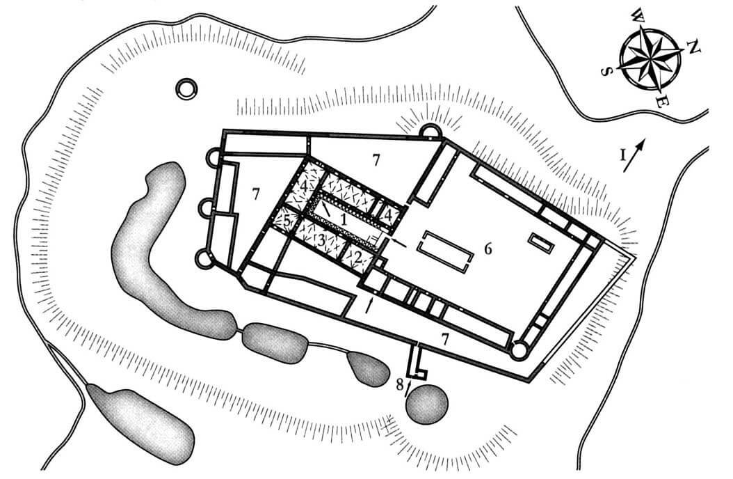
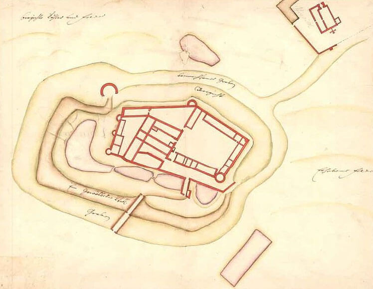
The castle was built on a hill above the Rauna river valley, on the eastern side of its bed. In the 14th century it consisted of a single rectangular courtyard, with three wings located along the internal facades of the walls. The eastern and southern wings had an internal width of about 9 meters, the western one was slightly narrower, 8.2 meters wide. The outer wall had a similar thickness in all parts, around 1.8 meters. The wall on the courtyard side was slightly thinner, 1.74 meters thick. The whole was about 47.4 meters long and 35.5 meters wide. The northern side, devoid of building, had only a single curtain, in the western part of which there was a gate. Next to it, in the north-west corner of the castle, at the end of the west wing, a four-sided tower was built, which was the most important element of the defense system.
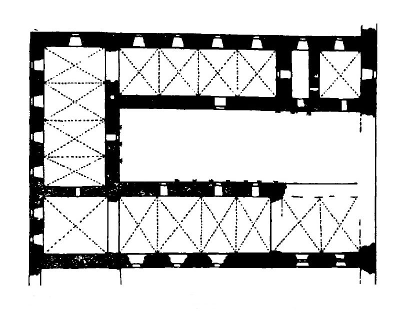
The ground floor of the upper ward buildings was traditionally occupied by utility and auxiliary rooms, the basements by pantries and stores, while the representative and residential chambers were located on the first floor. In the southern wing it was probably a four-bay refectory, in the western wing there were rooms for guests or the bishop’s private chambers, while the eastern wing housed a large hall and a two-bay chapel in the northern part. Communication was provided by an external cloister in the courtyard, originally wooden, then brick one, two-story. The element that distinguished the upper ward from other episcopal and Teutonic buildings was the partial use of wood in the upper storeys of the castle and a mono-pitch roof going inwards, instead of the traditional gable form.
On the north-eastern side of the upper ward there was a bailey, initially unfortified, then surrounded by a wall, to the inner walls of which longitudinal economic buildings were added. In the 15th and 16th centuries, together with the entire upper ward, it was strengthened with a second ring of external walls, which enlarged the entire complex to approximately 180 meters in length and 90 meters in width. The outer wall was equipped with at least five semi-circular towers, three of which were located from the south, and one from the west and north-east. The new fortifications separated the area of the zwinger, apart from the north-western part of the castle, where there was no enough space due to the slopes of the hill. Over time, economic rooms were built in the zwinger area. An additional element of defense was a free-standing cylindrical tower located from the south-west and fish ponds acting as a moat, protecting the castle from the east. An unconventional solution was the main entrance to the castle, partially underground, in front of the line of the outer eastern wall.
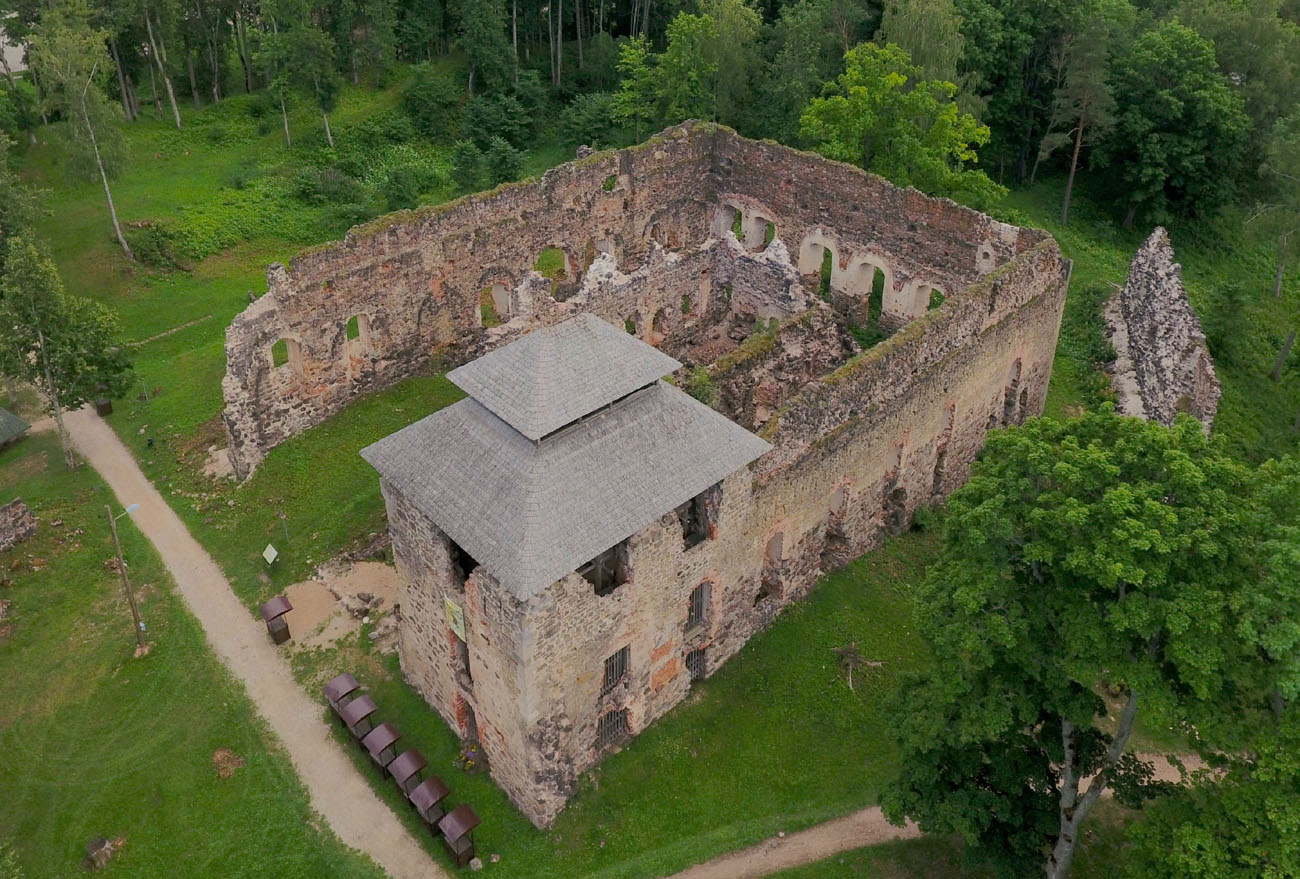
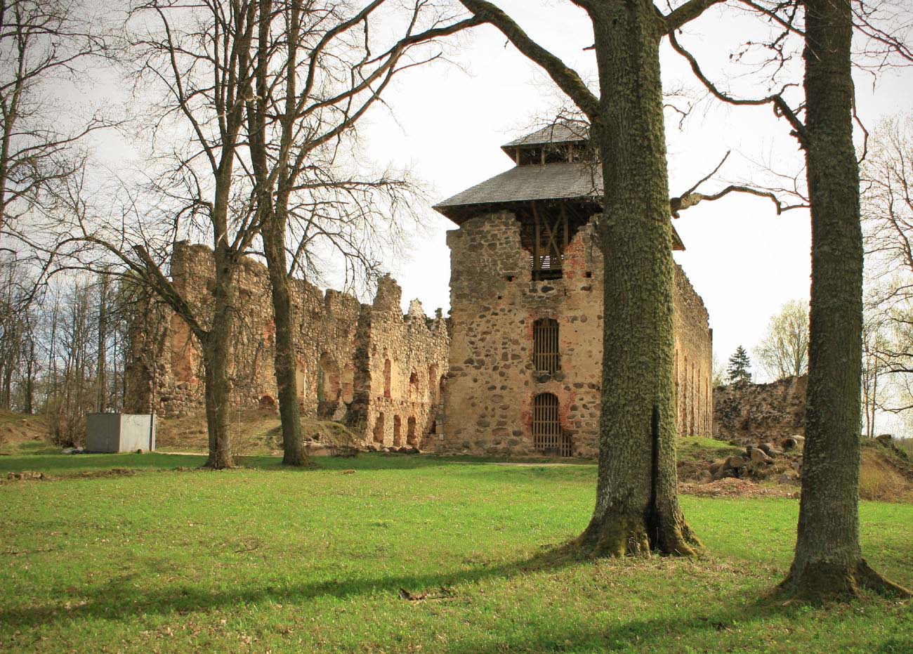
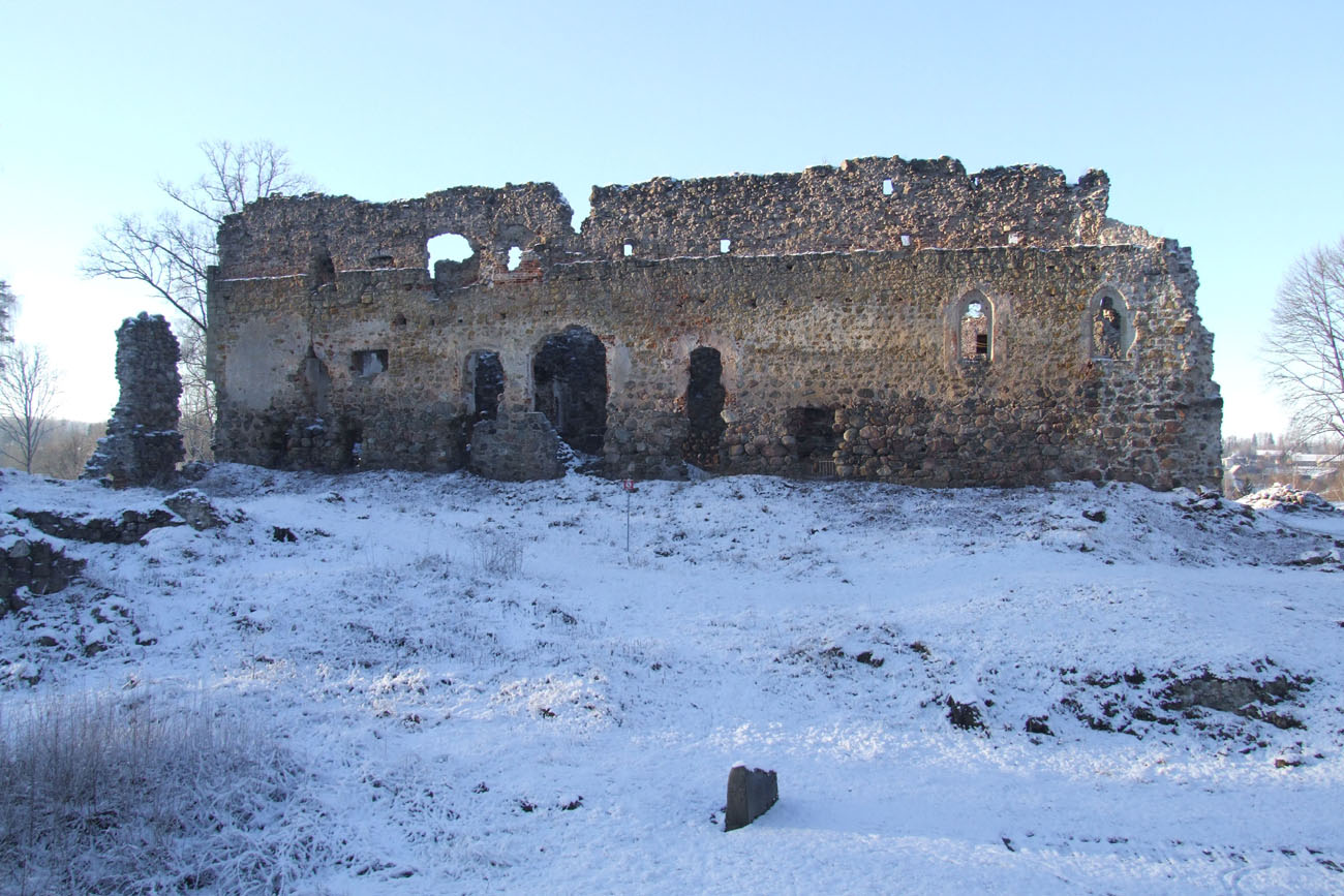
Current state
Since the destruction and demolition works from the 17th and 18th century mainly covered defensive elements, large fragments of the representative and residential part of the upper ward have survived today, in the form of the perimeter walls of three wings. The lower part of the main, four-sided tower is also distinguished, preserved approximately to the level of the third floor. Only modest stone relics remain of the former bailey and external fortifications. After limited archaeological and conservation works were carried out in the upper ward, including the north tower, in the years 2005-2012, a wooden staircase and a viewing platform were built.

bibliography:
Alttoa K., Bergholde-Wolf A., Dirveiks I., Grosmane E., Herrmann C., Kadakas V., Ose I., Randla A., Mittelalterlichen Baukunst in Livland (Estland und Lettland). Die Architektur einer historischen Grenzregion im Nordosten Europas, Berlin 2017.
Borowski T., Miasta, zamki i klasztory. Inflanty, Warszawa 2010.
Herrmann C., Burgen in Livland, Petersberg 2023.
Turnbull S., Crusader Castles Of The Teutonic Knights. The Stone Castles Of Latvia And Estonia 1185-1560, Oxford 2004.
Tuulse A., Die Burgen in Estland und Lettland, Dorpat 1942.